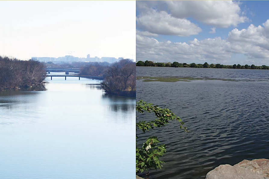
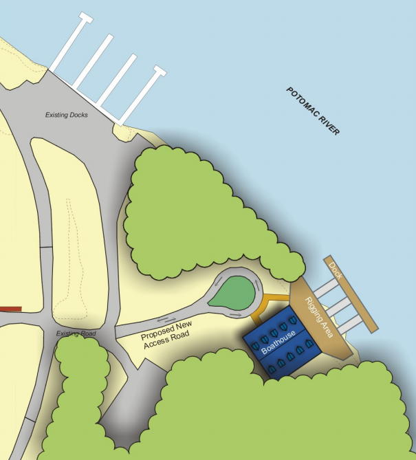
Arlington County negotiated for three decades with the National Park Service to locate a boathouse opposite Teddy Roosevelt Island
Source: National Park Service, Arlington County and Vicinity Boathouse Environmental Assessment (June 2018)
Arlington County negotiated for three decades with the National Park Service to locate a boathouse opposite Teddy Roosevelt Island
Source: National Park Service, Arlington County and Vicinity Boathouse Environmental Assessment (June 2018)
The difficulty of locating a boathouse on the shoreline at Rosslyn demonstrated the current complexities of the border. Defining an acceptable location for a public rowing and paddling facility started in the 1970's. At the time, rowing clubs from Washington-Lee, Yorktown, and Wakefield high schools had to travel to Alexandria or Georgetown to get river access.
Demand for storing and launching boats exceeded the space available on the riverfront. There were 11 high schools and 5 college rowing teams using the Thompson Boathouse in Georgetown. Individuals seeking to rent rack space to store a "shell" had to wait 5-7 years. The Potomac Boat Club (PBC), the oldest in the area with a founding date in 1859, was so crowded that one observer commented:1
Rowing coach Charlie Butt was the prime advocate for building a new facility on the Little River Channel, which ran between the Virginia shoreline and Theodore Roosevelt Island downstream of the Key Bridge. He was the crew team coach at Washington-Lee High School for 42 years. Today, he is commemorated annually in the Charlie Butt regatta, sponsored by the Virginia Scholastic Rowing Association on the Potomac River.
The National Park Service did not support construction of a new building on the George Washington Memorial Parkway land along the waterfront. Charlie Butt focused on creating rowing facilities instead on the Occoquan Reservoir. What is now NOVA Parks established the Sandy Run Regional Park, and dedicated its waterfront to a scholastic rowing facility and racecourse used exclusively by Virginia high school and George Mason University rowing teams.
After the National Park Service constructed a 100-space parking lot and a pedestrian bridge to Teddy Roosevelt Island in 1990, Butt restarted campaigning for a boathouse. The Arlington Boathouse Coalition, then the Arlington Boathouse Foundation continued the effort after he died in 1991.
The National Park Service opposed construction of a boathouse on near Teddy Roosevelt Island for more than three decades. The superintendent of the George Washington Memorial Parkway made the agency's position clear in 1996:2
The Federal agency's concerns were shared by others who wanted to retain the riverfront as undeveloped land. A 2002 article in the Washington Post reported:3
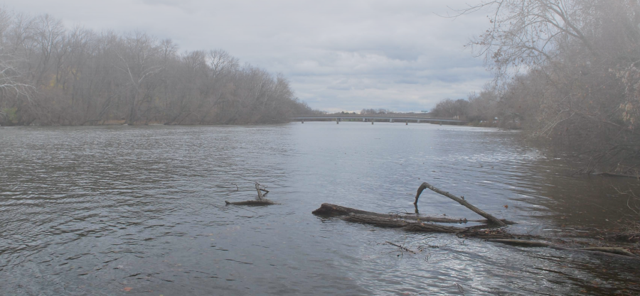
the National Park Service opposed constructing a boathouse that would disrupt Arlington's natural riverfront opposite Teddy Roosevelt Island
Source: National Park Service Public Scoping Meeting for Arlington County and Vicinity Non-Motorized Boathouse Facility
Arlington County had a legal argument that the National Park Service was obliged to provide access to the river. When the Federal government acquired land for the George Washington Memorial Parkway in 1934, it eliminated the existing commercial waterfront and boathouses at Rosslyn. Arlington claimed that an agreement with the Federal government at the time guaranteed the county would still have access to the river.
The National Park Service concurred that more public access was needed to the Potomac River in the Washington, DC area, but in a 1989 study it recommended adding four new boathouses in Georgetown on the opposite side of the river. Creating a row of multiple boathouses at just one location would leave the Virginia shoreline undisturbed and simplify management for the Federal agency. However, forcing high school team members to cross Key Bridge and go through crowded traffic in Georgetown to get to their boats was not satisfactory to the Virginia advocates.
Within Arlington County, the boathouse project was popular. Even though the county had no access point for it on the river, in 1992 voters approved $1 million in a 1992 bond referendum for construction of the facility.4
In 1996, the Water-Based Recreational Facility Task Force concluded that Arlington County should build a boathouse. Virginia legislators got the US Congress to direct the National Park Service to study potential sites on the Virginia side of the river. The feasibility study was completed in 2002.
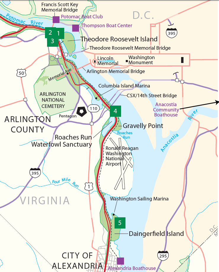
It considered four possible options, two on the Rosslyn waterfront downstream from Key Bridge, one upstream of Reagan National Airport next to the 14th Street Bridge, and one downstream of the airport at the Daingerfield Island marina. In addition, commenters suggested Potomac Yard, the existing Columbia Island Marina, and a location far upstream between Spout Run and Windy Run.
The two Rosslyn sites near Key Bridge would disrupt natural open space, but offered the safest water for rowing. They were the only ones with an established �no-wake� zone that reduced potential for conflicts with other boaters, and were closest to the Georgetown facilities with their safety support launches. At the 14th Street bridge site, the wide river there was popular with water-skiers whose boats produced wakes that might swamp a shell.
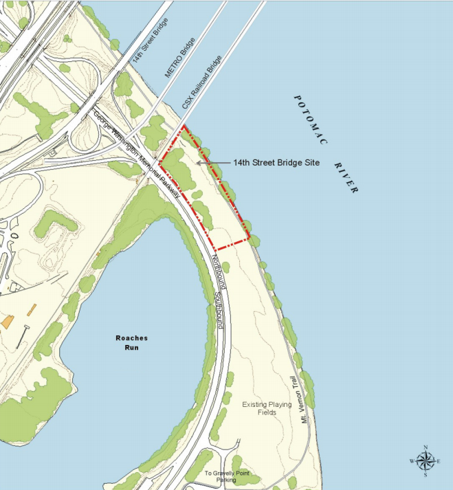
the 14th Street Bridge alternative would put rowing shells close to powerboats using the Columbia Marina and the boat-ramp at Gravelly Point
Source: National Park Service, 2002 Arlington Boathouse Feasibility Study (Chapter 3, Figure 3.32)
The 14th Street Bridge and Daingerfield Island sites offered little protection from winds. The team from T. C. Williams High School in Alexandria which used the Alexandria Community Boathouse further downstream, was often unable to practice before the Summer regatta season because of adverse weather conditions when teams had time to be on the water, typically between 2:45-5:30pm. A political complication was that the Daingerfield Island site would establish a boathouse for Arlington County schools outside the county, within the boundaries of the City of Alexandria.
The 2002 study included:5
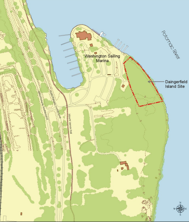
one alternative was the eastern end of Daingerfield Island, to the south of the existing Washington Sailing Marina
Source: National Park Service, 2002 Arlington Boathouse Feasibility Study (Chapter 3, Figure 3.53 and Figure 3.59)
The National Park Service proposed to complete a full Environmental Impact Statement, then scaled it down to an Environmental Assessment in 2004. Work stopped between 2006-2012.
Arlington County moved forward in 2005, completing a study that proposed a combination of elements associated with the two Rosslyn sites near Key Bridge. The National Park Service restarted preparation of an Environmental Impact Statement in 2012, with an anticipated completion date in 2013. A Final Public Scoping Analysis Report was published in August 2016.
In the end, the National Park Service completed an Environmental Assessment in 2018. The original 14th Street/CSX Bridge and Dangerfield Island site were dropped from consideration in that study. It chose as the preferred option the combination of upper and lower Rosslyn sites proposed by the county in 2005.6
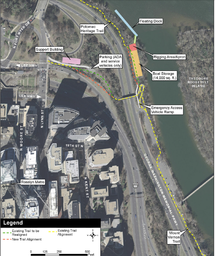
2018 alternative locations for a boathouse stretched from Key Bridge to downstream of Reagan National Airport
Source: National Park Service, Arlington County and Vicinity Non-Motorized Boathouse Facility - You're Invited
In 2014, Arlington County had paid $2.4 million to purchase a key parcel near the Key Bridge that was surrounded by National Park Service land. The developer had proposed a decade earlier to build a nine-story building with 70 residential units. The county was planning ahead, even though it had no money identified in its 10-Year Capital Improvement Program (CIP) for a boathouse.
Arlington also arranged for the Virginia Department of Transportation to vacate a planned road to the acquired parcel.7
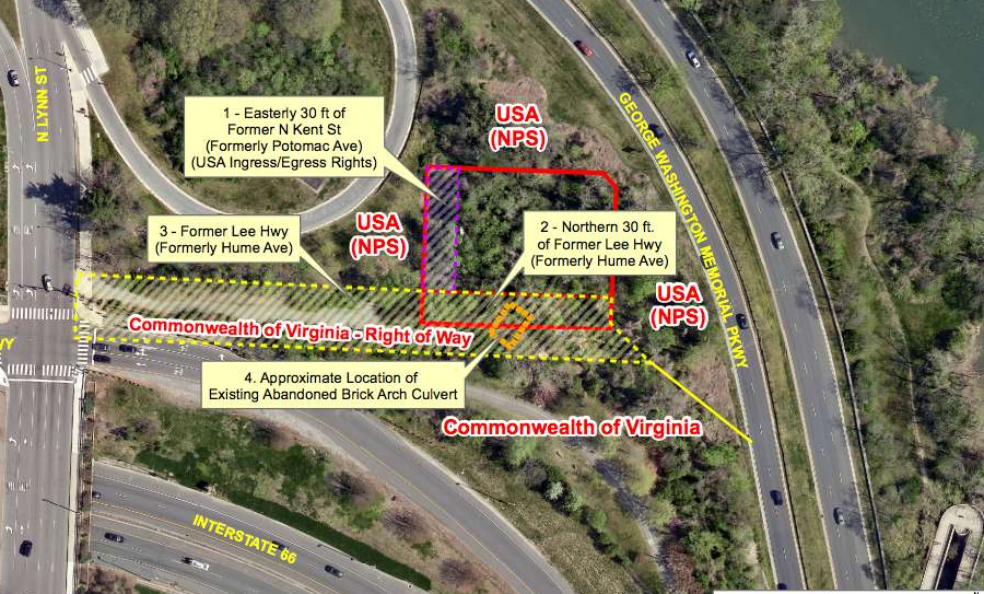
Arlington County purchased land for a boathouse project before funding the boathouse itself
Source: ARLnow, Arlington Boathouse Plan Slowly Moves Forward (December 13, 2016)
That parcel proved to be the key in overcoming National Park Service opposition. By building a support facility with offices, locker rooms and handicapped parking on it, above the flood plain, a smaller boat storage structure could be constructed on the edge of the river.
The preferred option proposed that vehicle access to the 14,000 square foot boathouse would be limited, making it accessible to the disabled but requiring boats to be brough in via the water from a separate lauunch site. A 300-foot long dock floating on the river would provide space for launching boats.
Environmental impacts included clearing over an acre and rerouting the Potomac Heritage Trail around the boathouse, plus dredging the river to provide a channel at least 3.3 feet deep.8
Getting agreement on where to locate the boathouse for Arlington school crew teams took over 30 years. Building the facilities was expected to require another decade. Design costs were expected to cost over $2 million. The additional funding for construction of the support facilities and boathouse was not anticipated to be included in the Arlington County budget until 2028. When completed, the three high school rowing programs, each with 100 participants, will finally have a home base within Arlington County.9
">
the preferred alternative for a boathouse project was chosen in 2018
Source: National Park Service, Arlington County and Vicinity Boathouse Environmental Assessment (June 2018, Figure 9)
1. "Public Spaces Master Plan," Arlington County, December 10, 2005, p.56, https://projects.arlingtonva.us/wp-content/uploads/sites/31/2016/01/2005-Public-Space-Master-Plan.pdf; �Potomac Boat Club,� DC Historic Sites, https://historicsites.dcpreservation.org/items/show/482; "New Boathouse Planned for Potomac," Rowing News, Volume 3, Number 8 (June 2-15, 1996), pp.14-15, https://books.google.com/books?id=FUcEAAAAMBAJ (last checked May 14, 2019)
2. "New Boathouse Planned for Potomac," Rowing News, Volume 3, Number 8 (June 2-15, 1996), pp.14-15, https://books.google.com/books?id=FUcEAAAAMBAJ; "Sandy Run Regional Park", NOVA Parks, https://www.novaparks.com/parks/sandy-run-regional-park; "Scholastic Rowing In The Northern Virginia Area," Virginia Scholastic Rowing Association Handbook, Tab 17A, 2019, http://www.vasra.org/2019_Handbook.html (last checked May 14, 2019)
3. "For Crew Teams, A Quest to Dock Closer to Home," Washington Post, August 15, 2002, https://www.washingtonpost.com/archive/local/2002/08/15/for-crew-teams-a-quest-to-dock-closer-to-home/31652751-3864-430b-aedb-9e69dea13bae/ (last checked May 14, 2019)
4. "New Boathouse Planned for Potomac," Rowing News, Volume 3, Number 8 (June 2-15, 1996), pp.14-15, https://books.google.com/books?id=FUcEAAAAMBAJ (last checked May 14, 2019)
5. "2002 Arlington Boathouse Feasibility Study Executive Summary," National Park Service, 2002, p.ES-5, p.IV-1, p.IV-4, p.IV-6, p.IV-8, https://parkplanning.nps.gov/showFile.cfm?projectID=13418&MIMEType=application%2Fpdf&filename=Cover%201%2Epdf&sfid=19429; "Arlington Boathouse Closer to Becoming Reality," ARLnow, February 9, 2012, https://www.arlnow.com/2012/02/09/arlington-boathouse-closer-to-becoming-reality/ (last checked May 14, 2019)
6. "Arlington County and Vicinity Non-Motorized Boathouse Facility - You're Invited," National Park Service, Summer 2012, https://parkplanning.nps.gov/showFile.cfm?projectID=13418&MIMEType=application%2Fpdf&filename=Newsletter%5Ffor%5FPEPC%5Frev%2Epdf&sfid=138683; "Document List - Arlington County and Vicinity Non-Motorized Boathouse Facility EA," National Park Service, https://parkplanning.nps.gov/projectHome.cfm?projectID=13418; "Arlington County and Vicinity Boathouse Environmental Assessment," National Park Service, June 2018, p.2, p.29, p.32, https://parkplanning.nps.gov/document.cfm?parkID=186&projectID=13418&documentID=89109 (last checked May 14, 2019)
7. "County Board Approves Acquisition of Lee Highway Property along Potomac River," Arlington County, May 13, 2014, https://newsroom.arlingtonva.us/release/county-board-approves-acquisition-of-lee-highway-property-along-potomac-river/; "What Arlington will pay to avert development on one small Rosslyn lot," Washington Business Journal, May 14, 2014, https://www.bizjournals.com/washington/breaking_ground/2014/05/what-arlington-will-pay-to-avert-development-on.html (last checked May 14, 2019)
8. "Just In: Park Service Selects Location Near Rosslyn as Preferred Site for Boathouse," ARLnow, June 29, 2018, https://www.arlnow.com/2018/06/29/just-in-park-service-selects-location-near-rosslyn-as-preferred-site-for-boathouse/; Arlington County and Vicinity Boathouse Environmental Assessment," National Park Service, June 2018, p.28, https://parkplanning.nps.gov/document.cfm?parkID=186&projectID=13418&documentID=89109 (last checked May 14, 2019)
9. "Arlington readies deal for new Potomac River boathouse near Rosslyn," Washington Business Journal, May 13, 2019, https://www.bizjournals.com/washington/news/2019/05/13/arlington-readies-deal-for-new-potomac-river.html; "Frequently Asked Questions," Arlington Boathouse Foundation, http://arlingtonboathouse.org/faq/ (last checked May 14, 2019)