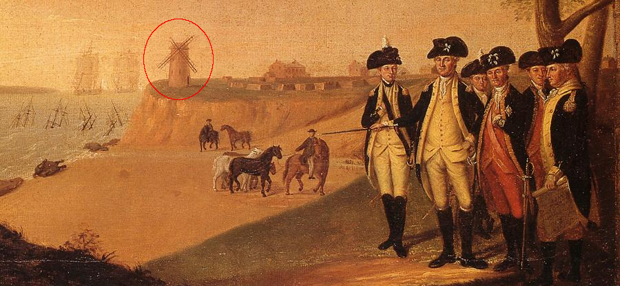
windmill at Yorktown during British surrender, 1781
Source: James Peale, Washington at Yorktown After Surrender, 1781
windmill at Yorktown during British surrender, 1781
Source: James Peale, Washington at Yorktown After Surrender, 1781
Since colonial times, wind has been utilized in Virginia for transportation, pumping water, and powering equipment. Gov. George Yeardley ordered construction of the first windmill in Virginia at Flowerdew Plantation in 1621. A traveler in 1647 noted that in the colony there were four windmills and five watermills used to grind grain, and a "Sawing mill for Boards" was needed.
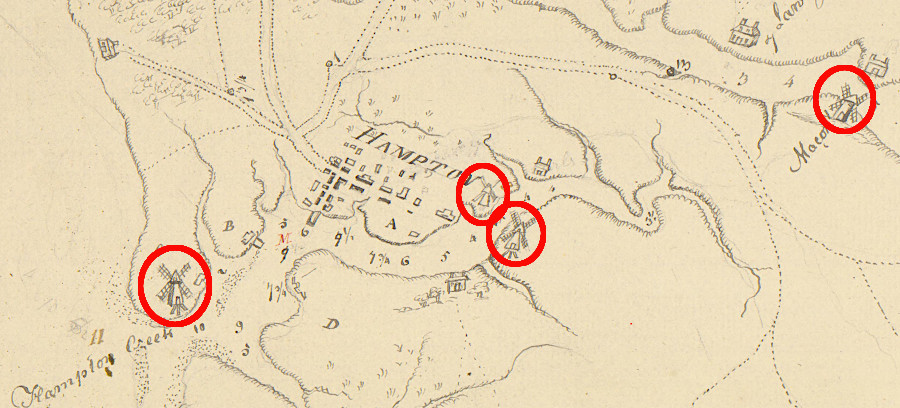
in 1781, there were four windmills in Hampton
Source: University of Michigan, William L. Clements Library, A sketch of the east end of the peninsula where on is Hampton (1781)
Though often considered to be a separate source of renewable energy from photovoltaic solar panels:1
High-tech windmills are now being assembled in wind farms on Virginia's mountains and offshore to generate electricity, helping utilities meet Renewable Portfolio Standards (RPS). The capacity of wind to generate electricity is now forcing local, state, and Federal officials to define what places are appropriate vs. "off-limits" for modern wind turbines.
For 400 years, from the 1500's into the 1900's, the Spanish, French, English, and other Europeans used the kinetic energy in wind to sail from Virginia back and forth to the Caribbean, Africa, or Europe.
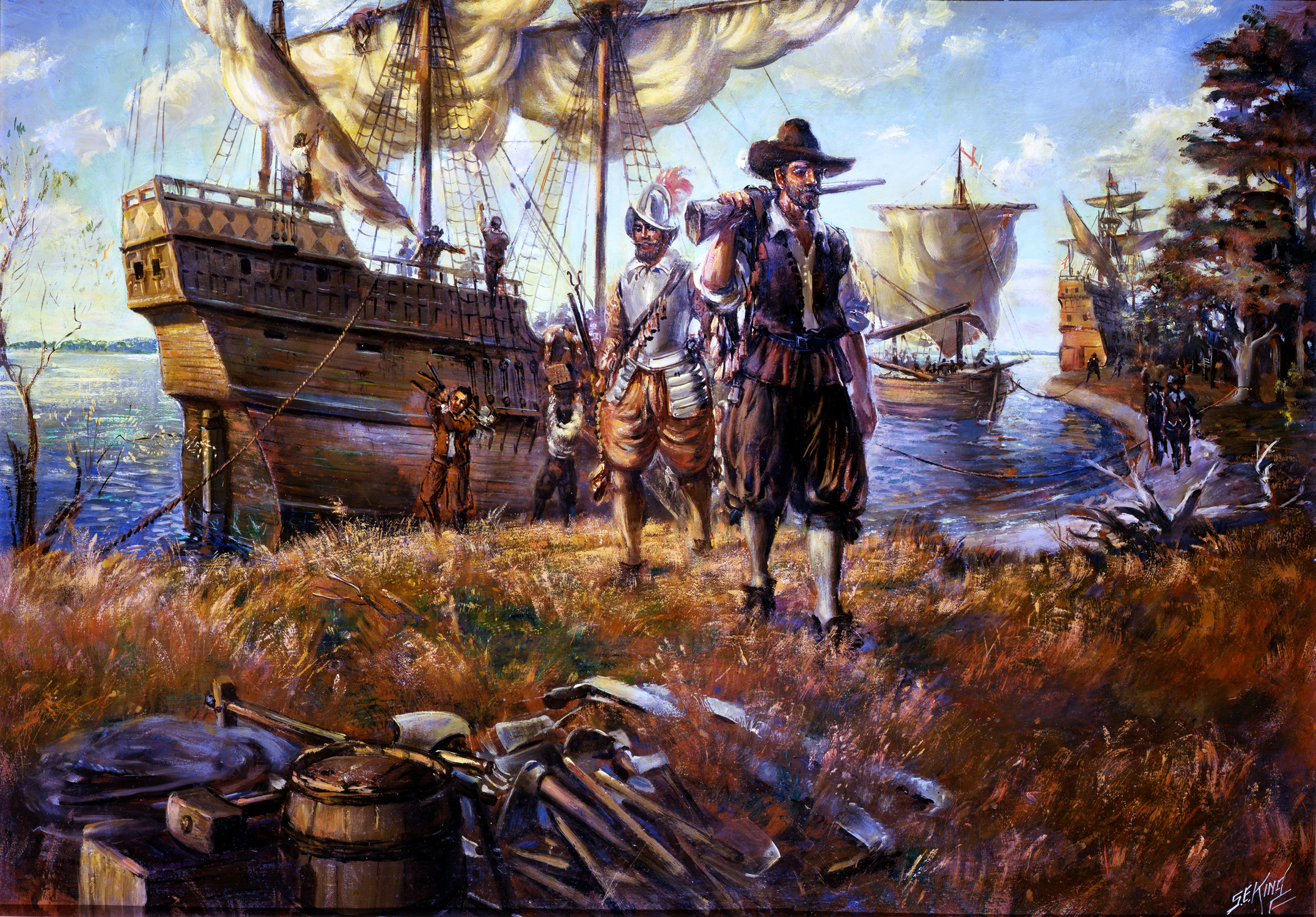
Susan Constant, Discovery, and Godspeed were wind-powered ships that brought English colonists to Jamestown in 1607
Source: National Park Service, Sidney King Paintings
Since the English settled Virginia successfully in 1607, rural Virginians also have used wind to draw water up from wells and to power manufacturing facilities, such as mills that ground wheat into flour.
Pumping and powering grist mills required that the windmill be located directly next to the facility - gears and belts could not transmit the mechanical energy more than about 100 feet. In Tidewater, windmills located on bluffs next to the river, as in Yorktown, could maximize the opportunity to catch a steady breeze.
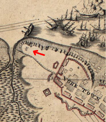
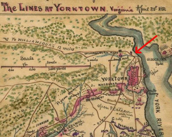
the windmill tower at Yorktown, shown on a French map in 1781, was "much in disrepair" prior to 1840
Source: Library of Congress, map by Sebastian Bauman, 1781 and
National Park Service, Yorktown's Main Street - Illustrations
Windmill Creek at Yorktown, in 1862
Source: Library of Congress, map by Robert Knox Sneden, 1862

the windmill at Yorktown, as seen from looking west on Main Street
Source: National Park Service, West View of Main Street (painting by Sidney E. King)
Today, almost all labor-saving devices in the home, office, or manufacturing plants use electricity that is generated far away from the site where the power is used. A handful of existing wind turbines convert wind energy to electrical energy. One of the first was a demonstration 10kW turbine at the Smith Mountain Lake Visitor Center.
More wind-powered turbines are planned in the mountainous regions of Virginia, and in the Atlantic Ocean east of the shoreline. Demand for more electricity is expected to increase along with the state's population. As more people are born in or move to Virginia, total demand for electricity in Virginia will climb - even if conservation efforts ultimately reduce demand/person.
The one-time infrastructure costs of building turbines and electrical transmission lines in remote areas is high, but the annual cost for fuel (wind...) is free. Even though electricity generated by wind costs more than electricity generated from coal, hydropower, or nuclear facilities, there are still customers for wind-generated electricity.
In addition to Federal tax advantages, some states are adopting Renewable Portfolio Standards that mandate a certain percentage of electricity generated or purchased within the state come from renewable sources. Urban regions not in "attainment" with Clean Air Act standards (such as Metropolitan Washington) seek credit for purchasing "green power" to meet pollution standards.
Virginia has defined voluntary (but not mandatory) Renewable Portfolio Standards in the 2010 Virginia Energy Plan. The state's Renewable Portfolio Standard is limited to investor-owned utilities, so it excludes electric cooperatives, municipal utilities, and industrial co-generation plants. The standard also excludes nuclear energy from the baseline. The optional target is to obtain 15% of the remaining sources of electricity from renewable sources by the year 2025.2
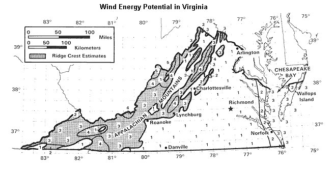
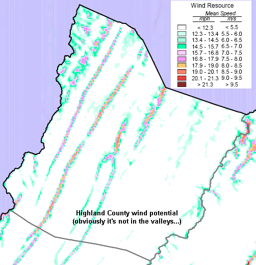
Virginia annual average wind power (note the Class 5 potential in Highland County)
Source: Wind Energy Resource Atlas of the United States
Classification schemes to evaluate potential wind energy vary. A "Class 3" location by one organization might be categorized as "Class 6" by another scheme. The Virginia Wind Resource Map summarizes the wind potential of the state at 50 meters above the ground, in simple language:3
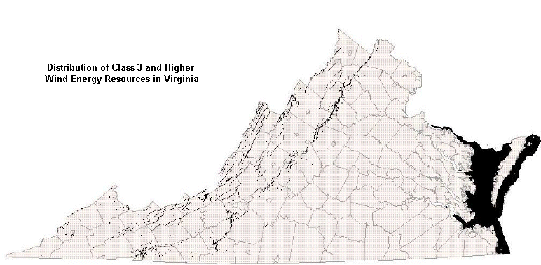
Ridges in the Blue Ridge, Ridge and Valley, and Appalachian Plateau physiographic provinces - and the open water region off the Outer Continental Shelf - are clearly the areas with Class 3 and higher winds that could power a modern turbine. The Piedmont and the Coastal Plain have fewer locations with high wind potential.
The greatest potential for generating electricity from wind energy in Virginia is to locate turbines in the mountains (a proposed wind farm in Highland County received the first zoning approval in Virginia). The potential for wind turbines to be located offshore (east of the Eastern Shore/Virginia Beach), producing electricity at anything but research scale, is lower.
Utilities seeking to generate electricity for sale look for at least Class 3 or higher zones, where wind speeds exceed 12.5 mph. Wind power maps often show speeds measuring "wind density," where Class 3 speeds are about 15 mph. Wind density accounts for the decline in atmospheric density at higher elevation; thinner air generates less power when pushing against a turbine blade.
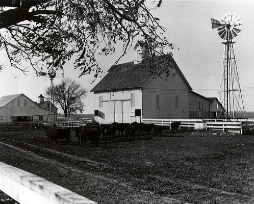
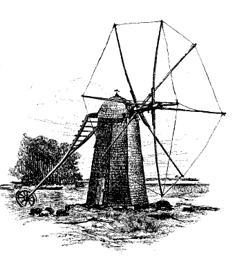
traditional farm windmill, good for pumping water up from a well
Source: National Renewable Energy Laboratory Photographic Information eXchange
The energy potential of a wind turbine increases dramatically as wind speed increases. The maximum energy output of a turbine at full speed is far greater than the likely production at average speeds... and the wind does not blow 24 hours/day, either.
Wind energy is often measured at 50 meters (164 feet) above the ground, but turbines on towers may be placed higher. Wind speed next to the ground is reduced by friction with vegetation and the surface of the ground. In engineering terms:4
To maximize wind speed that turns blades, windmills involve tall towers. If a turbine blade can be extended on a tower as much as 400 feet above the ground, the wind currents will be faster and steadier. The vertical distribution of wind speeds is not a simple "higher is always better" equation, but typically a tall windmill has greater potential to convert more wind energy into electrical energy, and produce more electricity at a lower cost.
However, a tall windmill will also be more visible from a distance; wind energy projects create scenic impacts. A turbine placed on a rooftop will not generate the same energy as a turbine on a 30-meter (100 feet) tower, but zoning in most residential areas blocks homeowners from building tall towers (and often blocks ham radio enthusiasts from building a tall antenna).
Areas zoned for commercial or industrial use may permit tall structures, however. Raising turbine blades far above trees on towers 150-400 feet tall increases the potential windpower that could be captured, but makes the turbines very obvious intrusions on top of forested mountain ridges. In addition, new transmission lines will require cutting new swaths through the forests, creating visual scars.
Source: Virginia Wind Energy Collaborative: Virginia Wind Resource Map with VWEC Activities, Wind power density at 50 meters
there are no major transmission lines in Highland County, so distribution costs are a deterrent to locating any generating facility (including wind turbines) there
Source: National Renewable Energy Laboratory -
United States Annual Wind Resource Potential
Geographic Information System (GIS) technology can be used to identify environmentally-sensitive locations that would stimulate objections to a proposed wind energy "farm" of multiple turbines:
On land, the taller mountain ridges in Virginia are the most attractive locations for electricity-producing wind turbines. Wind speed on the ridges is usually higher than in the valleys. Because the jet stream typically flows north of Virginia, windmills are feasible on low ridges in the northern part of the state. The closer to the North Carolina border, the higher the Virginia ridge must be to intercept strong and steady winds in all four seasons of the year:5

buffer zones drawn around sensitive environmental areas to identify Class 3 wind areas that may be more/less suitable for turbine locations
Source: Virginia Wind Energy
Collaborative, A Landscape Classification System: Addressing Environmental Issues
Associated with Utility-Scale Wind Energy Development In Virginia
Most wind energy projects in the mountains are located on private lands. Energy companies would rather pay a private landowner and go through a county planning process than request a permit from the USDA-Forest Service to place turbines on National Forest lands. Wind energy projects intended to generate power for sale must also get a certificate from the State Corporation Commission. Federal forests have existing stakeholders and land use plans that define primary uses for specific areas, and changing the designated uses to include wind turbines has been a difficult process.
would you buy stock in an energy company (or support an environmental organization) that planned to generate wind power along the Fall Line?
Source: Virginia Wind Energy Collaborative, Landscape Classification System For Virginia
Birds and bats are threatened by onshore and offshore wind farms. Towers and blades for wind farms installed in the United States by 2020, before a major expansion of wind energy facilities, were estimated to kill 140,000 and 679,000 birds annually. The average number of deaths per turbine is unclear, but may be 333-1,000 deaths annually.
However, the relative risk of wind farms was lower that the risks of conventional power plants. A 2009 study estimated that nuclear and fossil-fueled power plants resulted in over 2,000 dead birds for every one killed by wind turbines. Of an estimated 189 million birds killed annually by human activity in Canada, 135 million were killed by cats and less than 0.01% were killed by wind turbines.
One technique to reduce bat mortality is to start the movement of turbine blades only when wind speeds reach 4.5 meters per second, and not allowing them to freewheel without generating electricity. Bats are more active at times of low wind speeds, so bat deaths can be reduced by up to 40% by engaging blades only at higher speeds.
A 2020 study concluded that the impact of wind turbines on bat populations could be greater than the impact on bird populations:6
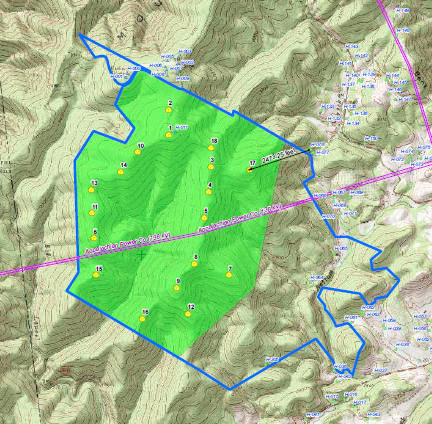
A proposal in 2005 to build turbines on a ridge in Highland County exposed the conflicts between tourism-based businesses and those who support wind farms. Multiple lawsuits were finally resolved in 2007 in favor of Highland County's rezoning. The wind farm, which would be the highest in the United States at over 4,200 feet, could have included 20 towers as much as 400 feet tall. However, after the approvals were finalized no towers were built.
Even within states with the climate and topography to generate a lot of wind energy, the locations for windmills are often in rural areas - requiring unsightly power lines to the urban areas creating the demand for power. As discussed in the Congressional debate:7
In early 2006, Community Energy, Inc. revealed its interest in building a wind farm in Patrick County. The immediate result was a decision by the local officials to tighten zoning restrictions. The new rules ensured that a special review process would be required, and a wind farm could not be constructed without clear approval from the county:8
A 2010 proposal by Invenergy Wind Development to build 135-meter high towers (443 feet) on Poor Mountain in Roanoke County generated conflict regarding the noise/visual impacts vs. economic/environmental benefits of wind-generated electricity. The Roanoke Group of the Sierra Club conditionally endorsed the project, acknowledging that the benefits of generating renewable energy at the site outweighed the predicted environmental impacts. Landowners objected to the towers, and Invenergy chose to delay rather than construct the project.9
Poor Mountain southwest of Roanoke
showing planned locations of up to 18 turbines on ridgetops
Source: Invenergy Wind Development, Poor Mountain Site Map
After Dominion acquired 2,600 acres on East River Mountain in Tazewell County near Bluefield and leased additional land, it proposed building towers up to 400 feet high to create the Bluestone River Wind Farm. The utility company initially partnered with BP Wind Energy on a joint effort to construct the 80-megawatt commercial wind farm on East River Mountain, and to build a similar Mill Creek Wind Farm at Black Mountain in Wise County on the Virginia-Kentucky border.
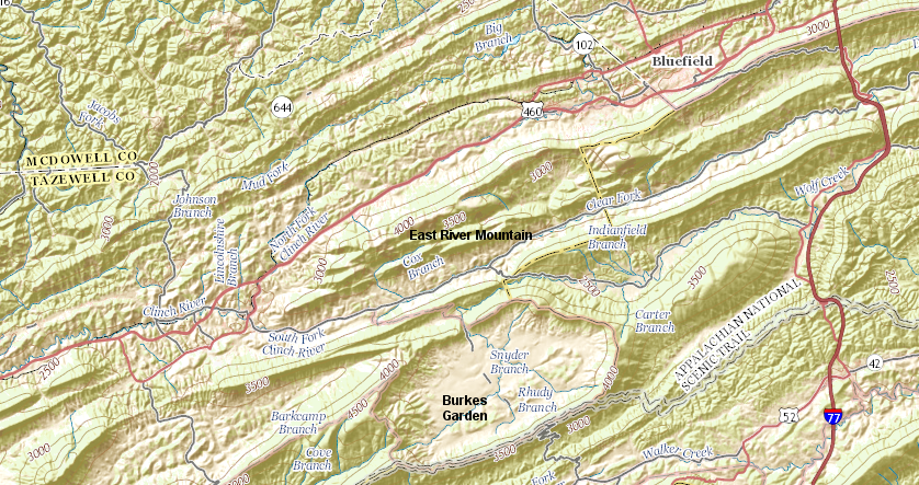
Dominion's plans to build the Bluestone River Wind Farm on East River Mountain were blocked by a ridgeline protection ordinance adopted in 2010 by the Board of County Supervisors in Tazewell County
Source: ESRI, ArcGIS Online
The Mill Creek Wind Farm project was projected to generate up to 150 megawatts of electricity, depending upon final design. Wise County officials easily endorsed the proposed Mill Creek Wind Farm in 2009. Local environmental groups, including the Clinch Coalition and the Wise Energy for Virginia Coalition, also endorsed the renewable energy project. Those groups opposed mountaintop mining of coal in southwestern Virginia and West Virginia. In 2009 they saw wind-generated electricity as an alternative to completing the Virginia City Hybrid Energy Center in Wise County, which was fueled predominantly by coal.
Public support was less supportive of the Bluestone River Wind Farm in Tazewell County. The towers would affect scenic vistas, and the county was seeking to expand tourism as employment dropped in the coal mines. Tazewell County had no zoning ordinance in 2009, but county supervisors adopted a tall structure ordinance in 2010 to limit structures taller than 40 feet of certain ridges.
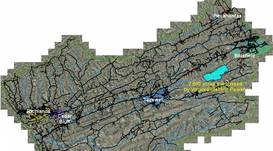
Virginia Electric Power (a subsidiary of Dominion) purchased 2,600 acres in Tazewell County and leased other lands for a commercial wind farm
Source: Tazewell County,
Tazewell GIS Mapping Website
In 2011, local delegates serving in the General Assembly blocked an effort to revise state law to override the county ordinance and allow the utility company to build the wind farm despite local opposition. State legislators did pass a law that limited the effect of future local ordinances to protect ridgelines, but declined to retroactively repeal Tazewell County's use of its land use authority.
In 2011, BP Wind Energy took full control over the proposed wind farm project in Wise County. Dominion took over responsibility for the proposed Bluestone River Wind Farm in Tazewell County.
The 2008-13 economic recession delayed action on both projects, but in 2015 Dominion made clear that it wanted to build the Bluestone River Wind Farm at East River Mountain in Tazewell County. That triggered new local efforts to establish an ordinance for just the Eastern District of the county, where the commercial wind farm would be located. The ordinance limiting structure heights on ridge lines established a mechanism for the county to block the wind turbine proposal.10

the proposed Bluestone River Wind Farm spurred efforts in 2015 to adopt a zoning ordinance limiting structure heights on ridge lines in the Eastern District of Tazewell County
Source: Tazewell County, Draft Eastern District Zoning Ordinance (February 12, 2015)
In 2012, EDP Renewables North America proposed to construct 20-24 wind turbines on 3,000-foot high Stoots Mountain in Carroll County, near the Wythe County border. Electricity generated at the 72 MW Poplar Camp Project would connect to the grid via American Electric Power's Jubal Early–Austinville 138 kV transmission line.
The Federal Aviation Administration (FAA) determined that the 591-foot tall towers could create a hazard for airplane traffic, including a path used for military training. After consultation with the Defense Department, EDP Renewables agreed to install lights on the towers that would not impact the night vision goggles used by military pilots. The Federal Aviation Administration issued a Determinations of No Hazard for the Poplar Camp project in 2020.11
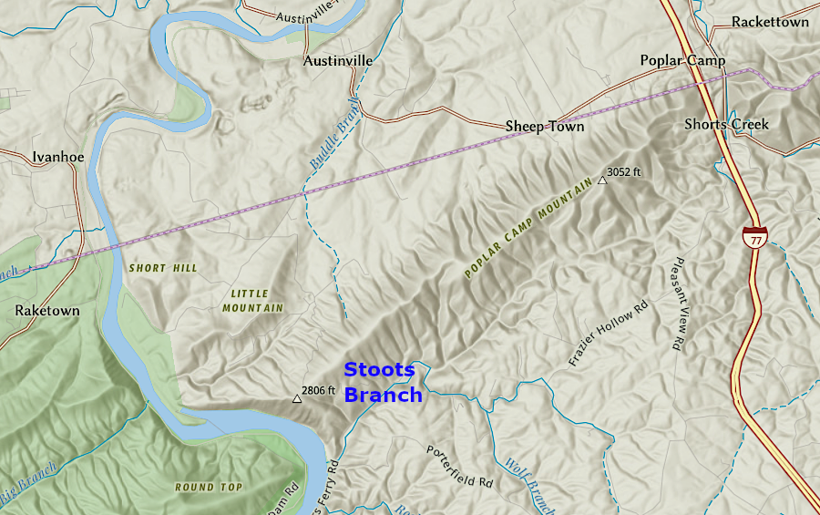
the proposed Poplar Camp Project in Carroll County is next to a transmission line (purple line)
Source: ESRI, ArcGIS Online
In 2010, Governor Bob McDonnell articulated a goal of making Virginia the "energy capital of the East Coast" and included windpower in his plans. Research and planning for offshore wind projects were starting to be followed by investment, with the expectation that wind-generated electricity can compete with traditional sources - especially if coal prices climbed, as international customers such as China increased demand for coal faster than mines could increase supply.
Then the fracking boom increased supplies of natural gas and energy prices dropped. By 2015, there were still no commercial wind farms in Virginia, but at that time onshore project proposals were advancing faster than any proposed offshore wind projects.
Despite the lowered cost of fossil fuels, Apex Clean Energy leased 7,000 acres on North Mountain near Eagle Rock and proposed the $150 million Rocky Forge Wind Project. The 25 turbines, placed in a Y-pattern following the ridgelines, could generate 80MW of electricity. The location was attractive because of the 15-20mph winds and the remoteness from neighbors.
The 200 acres with turbines would be a mile away from the closest home. Nonetheless, some county residents filed suit to block the project and prevent low-frequency noise from affecting their quality of life.
simulation of Rocky Forge Wind from its closest neighbor
Source: APEX Energy, Bringing Clean Energy Home To Virginia
The Federal Aviation Administration initially ruled that the towers would be a hazard to aircraft, since they would be taller than 499 feet. The Federal agency reversed the decision after concluding there were no airports nearby that would cause aircraft to fly low, using visual flight rules. It did end up requiring the towers include white paint and red lights, making them more visible to pilots but also to people living in the area.12
One major advantage to the North Mountain location was the ability to use existing transmission lines on North Mountain. The Rocky Forge site did not require cutting new paths through the woods for distribution lines, which would have generated greater opposition from environmental groups concerned about the impacts of forest fragmentation.

the proposed Rocky Forge Wind project could link to the grid through existing electrical transmission lines (red line) at the southern end of North Mountain
Source: ESRI, ArcGIS Online
Botetourt officials responded by adopting a local ordinance for locating wind towers, allowing commercial wind farms with a Special Use Permit. In 2015 Apex Clean Energy built two test towers almost 200' high to assess the potential on North Mountain in more detail.
The revised county zoning ordinance authorized approval in areas zoned for agricultural or forest use of towers up to 550 feet tall (which would exceed the height of the tallest building in downtown Roanoke). The ordinance defined how close tall towers could be located near houses, and required that the noise of spinning blades not exceed 60 decibels beyond the property line. Local county supervisors received strong public comments, including the following:13
Source: Apex Clean Energy, Capitalizing on Complementary Resources
When Botetourt County was poised to approve the Special Use Permit authorizing final construction of the Rocky Forge wind turbines, the supervisors in neighboring Rockbridge County asked for a delay. The opponents of the windfarm had failed to convince the officials in Botetourt County that the proposal should be blocked, in part because most residents in that county lived to the south and would not see the towers.
Residents in Rockbridge County would have their vista affected. The Rockbridge Area Conservation Council helped generate opposition to the Special Use Permit, but local government has authority over local zoning. The Rocky Forge site was not located in Rockbridge County, so the authority of supervisors in that county were limited. They could ask for special consideration of their concerns by Botetourt County officials because the counties were neighbors, but Rockbridge County officials had no power to stop the project.14
The Virginia Department of Environmental Quality resolved concerns regarding environmental impacts in 2017. It concluded that there was just one significant concern. Bats could be killed by the turbines, so Apex Clean Energy agreed to stop spinning the blades on warm nights when bats emerge from their hibernation caves and the threat was highest.
Economics delayed development of the Rocky Forge project. In 2019 Gov. Ralph Northam committed the state to purchase at least 30% of its electricity from renewable sources by 2022, and Dominion Energy contracted with Apex to purchase the 75 megawatts of electricity from the wind farm to assemble a "green package" for the state. Local supervisors in Botetourt County remained supportive, anticipating substantial tax revenues once Apex completed construction of the first commercial wind farm in Virginia in 2021.
The company needed their support because it wanted to change the original proposal. It planned on using new technology to build 13-22 towers up to 680 feet tall, rather than the 25 towers approved with a maximum turbine height of only 550 feet.15
The Roanoke Times commented that the site for Virginia's first onshore wind-fired power plant was uniquely suitable:16
One local resident said at a public hearing, where the county supervisors initiated the planning review process for the taller towers:17
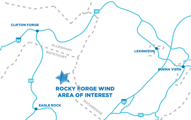
the Rocky Forge Wind Project was near Rockbridge County, but Apex Clean Energy needed zoning approval from officials only in Botetourt County
Source: Apex Clean Energy, Rocky Forge Wind Project Profile
Opposition to the taller towers almost succeeded in blocking Botetourt County approval. Elected officials were sensitive to the concerns about ridgeline development that scarred scenic vistas and limited tourism potential. The May, 2020 vote by the Board of Supervisors to authorize wind turbine towers as high as 680 feet was only 3-2 in favor of the project.
The subsequent site plan filed by Apex requested approval of 15 turbines reaching 624 feet in height. Advances in turbine technology allowed the company to plan to generate 75MW (megawatts) at maximum production with just 15 turbines. It later modified plans and proposed building 14 turbines on towers 612 feet tall.
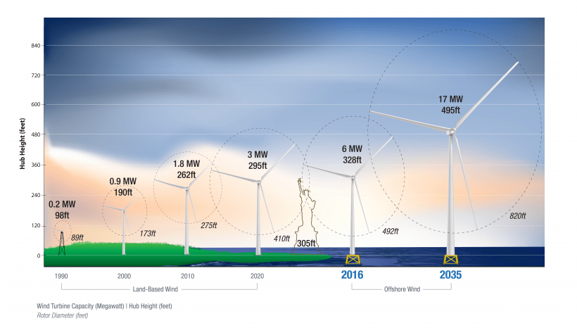
wind energy technology has led to higher towers and more powerful turbines
Source: US Department of Energy, Top 10 Things You Didn’t Know About Offshore Wind Energy (August 30, 2021)
Local residents organized as "Virginians for Responsible Energy" continued to fight the project. The group filed a lawsuit when the Virginia Department of Environmental Quality issued an approval.
In 2021, the Botetourt County zoning administrator determined that Apex Energy had failed to meet a deadline for county approval of its site plan. The county official declared that the special use permit for the Rocky Forge Wind project had expired, and therefore no building permit could be issued. He determined that the preliminary proposals submitted by the company did not qualify as an adequate site plan. In addition, the company had not commenced the project or incurred significant expenses that would qualify the project for a delay authorized by state law due to the COVID-19 pandemic.
Apex Energy sought to overturn the zoning administrator's decision, following standard administrative processes by going first to the county's Board of Zoning Appeals. Other options included filing a lawsuit and seeking special legislation at the General Assembly.18
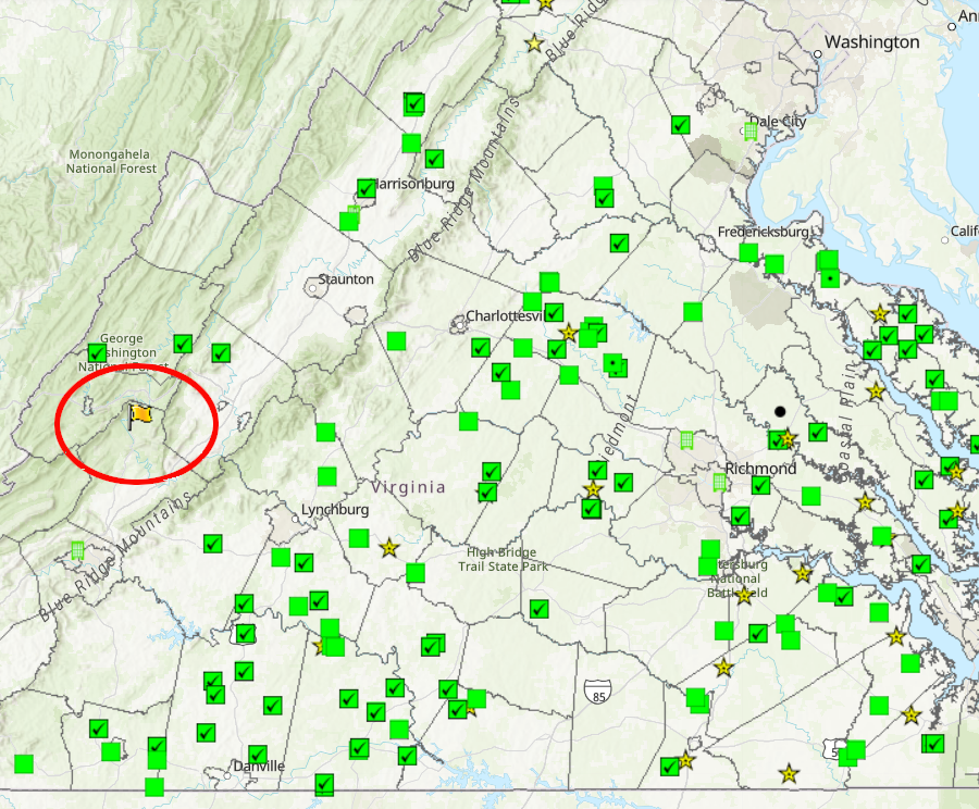
Rocky Forge Wind was the one onshore wind project in Virginia in 2022, surrounded by multiple solar projects in different stages of development
Source: Department of Environmental Quality (DEQ), Environmental Data Mapper
The opponents also had legal options. They filed suit to block the Permit by Rule modification made by the Virginia Department of Environmental Quality. The state agency had authorized fewer, taller turbines. The Virginians for Responsible Energy and neighbors asked a state court to intervene.
To gain "standing" in a lawsuit, the plaintiffs had to show harm or impact from the proposed action. In 2021 a Botetourt County Circuit Court judge allowed the suit to proceed, despite objections from Apex Energy that the neighbors lived too far away. None lived within a mile of the project on North Mountain, and no previous Virginia Supreme Court decision had granted standing to a plaintiff living more than 2,000 feet away. One of the plaintiffs lived 23 miles away, and claimed potential impacts from low-frequency "infrasound" noise.
A judge in Botetourt Circuit Court ruled that the plaintiffs had standing. The previous court rulings had involved ground-level projects, not towers nearly 700 feet high.
The judge ruled that procedural errors by the Virginia Department of Environmental Quality (DEQ) required reopening the public comment period, but did not invalidate the permit. The delay gave opponents the opportunity to argue that the studies of the threat to golden and bald eagles were inadequate, and an additional delay of two years for assessing the risks was needed.
In 2022, the Department of Environmental Quality again approved the Rocky Forge Wind project. Apex Energy announced it would proceed with construction of 13 turbines on towers 634 feet tall once all local permits had been obtained, rather than wait to get a signed contract with a purchaser committing to buy the 75MW of electricity.
One possibility was for Dominion to renew its power purchase agreement with Apex, which had expired at the end of 2021. By the end of 2023, Apex was able to cut trees at the site but had no other final authorizations. It also lacked a contract with any customer willing to purchase the renewable energy.
The company won two lawsuits in 2024 that enable it to proceed with plans to start building towers in 2024 and be operational by the end of 2025. In December 2024, Apex announced it had signed a power purchase agreement with Google for purchase of the 80MW of electricity to be generated by the 13 wind turbines.
By the start of February, 2025, construction had finally started on Virginia's first onshore wind farm. To get final state approval, Apex had agreed to stop spinning the turbine blades at night during warm months when bats are active.
In 2025, Google purchased 300 acres at the 750-acre Botetourt Center at Greenfield industrial park in Botetourt County to build three data centers. That completed sales of land in the industrial park. Data centers, like wind farms, were controversial developments. A Botetourt County supervisor commented:19
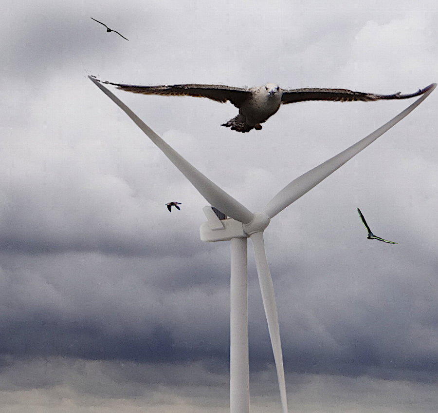
the taller wind towers could affect the risk of bird strikes, including golden and bald eagles
Source: Public Domain Pictures, Triangle of the Wind (by Axel Kuhlmann)
The willingness of the state government to purchase the wind-generated energy, technological changes reducing the cost of turbines, the desire of large corporations to buy renewable energy, and passage of the Virginia Clean Economy Act in 2020 were expected to be key factors in stimulating other onshore wind projects.
In 2015, Apex Clean Energy had proposed the Pinewood Wind project in Pulaski County. The company proposed to build a 180MW commercial wind farm on 17,000 acres of property owned by the Boys Scouts of America, used for summer camps and organized retreats. Pulaski County had amended its zoning ordinance in 2010 to control the location of commercial wind farms. The county limited noise levels to 55 decibels but had imposed no pre-set limit on the height of towers.
Apex indicated it was willing to proceed with the Pulaski County project as well as Rocky Forge. In 2022, the company had to find a buyer for the renewable energy that would be generated from both projects. Apex appeared to prioritize completing the Rocky Forge Wind project first, after getting state approval for that proposal renewed.
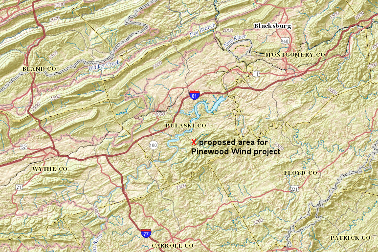
the Pinewood Wind project in Pulaski County, proposed by Apex Clean Energy in 2015, would be located on property owned by the Boy Scouts east of Claytor Lake
Source: ESRI, ArcGIS Online
Dominion still owned 2,600 acres on East River Mountain, acquired in 2009 with plans to build the Bluestone River Wind Farm. The utility had considered building the $2 billion Tazewell Hybrid Center project there. It would be a pumped storage facility using two lakes separated by 1,000 feet in elevation to store energy like a battery, comparable to the Bath County Pumped Storage Station.
The 2022 Virginia Energy Plan claimed to support an "all of the above" approach to generating electricity, and even recommended a nuclear reactor be constructed within 10 years in Southwest Virginia. However, the plan did not mention the Tazewell Hybrid Center or the Bluestone River Wind Farm.20
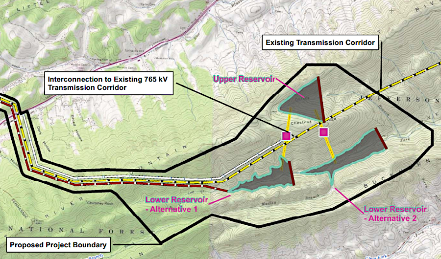
East River Mountain was considered for the Tazewell Hybrid Center pumped storage project with an upper and lower lake, as an alternative to the Bluestone River Wind Farm
Source: Dominion Energy, Tazewell Hybrid Energy Center
By 2021, West Virginia had an installed onshore wind turbine capacity to generate 742 megawatts. Maryland had around 200 megawatts, as did North Carolina. Virginia had two offshore turbines, but no commercial onshore facilities.
In 2022 Altria, the parent company of tobacco manufacturer Philip Morris USA, signed a contract to purchase 400,000 megawatt hours annually of wind-generated electricity. That helped meet a commitment to offset the company's greenhouse gas emissions. The company had to go to Texas to find a 300MW wind farm capable of generating that amount of renewable electricity. Purchasing wind energy in Texas had the same impact on the world's climate as purchasing wind energy in Virginia, though none of the electricity generated at that Texas wind farm would ever reach an Altria facility in Virginia, Kentucky, or Tennessee.21
REV Renewables, an affiliate of LS Power, proposed in 2021 placing seven wind turbines on Buck Mountain and Whitetop Mountain in Grayson County. Local residents expressed both concerns and support. Concerns included impacts on bird migration, scenic vistas of the ridgetops, and tourism. Supporters noted the need for renewable energy, and suggested that the Christmas tree industry had already damaged the landscape. One resident said the Christmas tree farms made the top of Buck Mountain appear to have been strip-mined, so towers with turbines would not be a detriment to the vista.22
The State Corporation Commission regulates the rates charged by investor-owned utilities in Virginia. The state has granted those utilities a monopoly on providing electricity within their service areas. There is no price competition for buying electricity for residential use; homeowners can not switch to another utility in the same way they can chose to buy food from a competing supermarket.
Wind-generated electricity may be renewable with free fuel, but the initial costs to create a wind "farm" are high. To ensure reasonable rates, the State Corporation Commission must approve new generating plants that will be included in the "rate base" of Dominion Power or Appalachian Power.
If the costs of electricity from wind turbines would end up higher than the cost of electricity generated from other sources, the State Corporation Commission normally would not authorize the project. However, the General Assembly has declared that using renewable energy from wind and solar (as well as the coal-fired Virginia City Hybrid Energy Center) is "in the public interest."
In the best case scenario for sustainable energy advocates, research would demonstrate electricity from wind will drop below the costs to generate electricity from fossil fuels. The construction costs for wind turbines that generate electricity only intermittently may be relatively high, compared to the cost-per-megawatt for baseload plants running on fossil fuels. That high, one-time cost may be offset by the low costs to operate wind turbines over the life of a wind farm since the fuel is free.
If those economics become clear, then the State Corporation Commission would authorize Dominion Power to build wind farms. Virginia would transition to renewable energy sources, and existing power plants that create carbon dioxide and other pollutants would be closed over time.
The changing economics of renewable energy sources create a financial risk for investors in utilities. If wind, solar, or other new alternative fuel technologies could out-compete fossil fuels and nuclear power quickly, then Dominion Power might have to close existing power plants even before the end of their useful life.
In the worst case scenario for the utility shareholders, the State Corporation Commission would not approve rate increases to offset the "stranded costs" of prematurely-closed facilities, reducing the value of Dominion Power's stock.
Such a scenario would require rapid development and implementation of wind, solar, and other technologies and/or substantial reduction in the demand for electricity through conservation, with a transformation of the electrical generation system in 10-30 years. If widespread adoption of alternative fuels could be delayed for several decades, then Dominion Power could amortize its investment in existing power plants by the year 2050 at the latest.

the higher the elevation, the greater the onshore wind power potential
Source: Virginia Department of Energy, Energy Resources
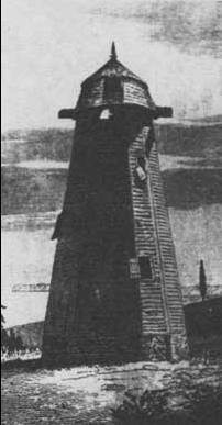
after the Civil War, windmills in Northampton County were abandoned and the sails rotted away
Source: Library of Congress, A Peninsular Canaan in Harper's New Monthly Magazine (May 1879)

in 2022, Virginia had no wind turbines generating electricity in the mountains
Source: Energy Information Administration, U.S. Energy Mapping System
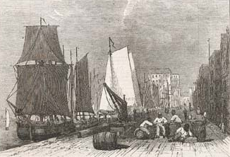
until the Civil War, international transportation was based on wind energy
Source: Illustrated London News, The City Quay, Richmond (May 31, 1862)

railroads used windmills to pump water into tanks for refilling steam-powered locomotives
Source: Alfred R. Wolff, The Windmill as a Prime Mover (Figure 20)