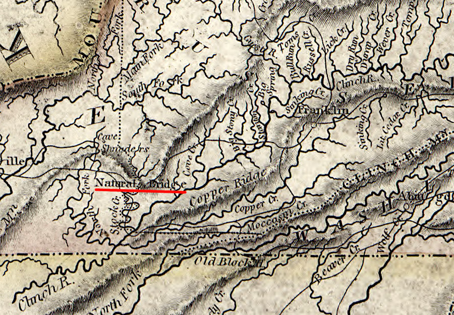
Natural Tunnel was labelled "Natural Bridge" on an 1814 map
Source: Library of Congress, A new map of Virginia with Maryland, Delaware & v. (by Samuel Lewis, 1814)
Natural Tunnel was labelled "Natural Bridge" on an 1814 map
Source: Library of Congress, A new map of Virginia with Maryland, Delaware & v. (by Samuel Lewis, 1814)
Natural Tunnel was discovered by Paleo-Indians perhaps 20,000 years ago. It was given its name by Lt. Col. Stephen H. Long in 1831.
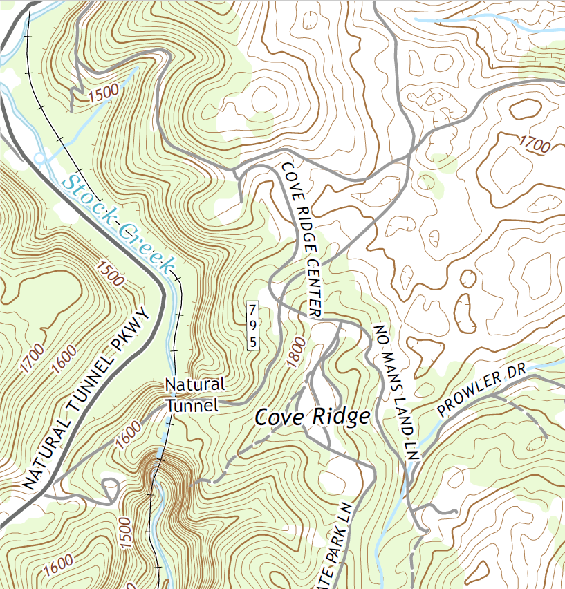
Stock Creek, a tributary of the Clinch River, flows through Natural Tunnel. Modern Bishoptown Road (Route 646) crosses over the tunnel, comparable to how US 11 crosses Natural Bridge in Rockbridge County. The Norfolk Southern railroad runs through the tunnel, still hauling coal on a route first built in 1890.

Bishoptown Road crosses over Natural Tunnel, while a railroad runs through it
Source: ESRI, ArcGIS Online
Unlike Natural Bridge, Natural Tunnel is not a collapsed cave. Instead:1
The geologic feature lies within the Valley and Ridge physiographic province. Differential erosion created the topography. Bedrock in the valleys is relatively easy-to-erode limestone and dolomite. The ridges are formed from slower-to-erode sandstones. Natural Tunnel is within the Chepultepec and Copper Ridge Formations of the Knox Group.2
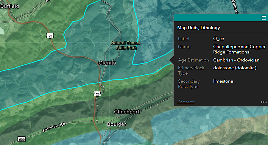
Natural Tunnel is within the Knox Group of sedimentary formations deposited about 450 million years ago
Source: Virginia Department of Energy, Geologic Map of Virginia (1993)
The layers of the Knox Group were deposited in the Paleozoic Era during the Cambrian to the Ordovician periods. The sediments accumulated in shallow marine waters. What is now Scott County was on the passive margin of the edge of Laurentia until the start of the Taconic orogeny.
The diagenesis of the sediments, the physical and chemical changes to create the bedrock formations, resulted in magnesium replacing some calcium. Dolomitization involved recrystallization of the calcite - Ca(C03). The resulting dolomite had both calcium and magnesium bonded with carbonate ions - CaMg(C03). The sediments also experienced silicification to create chert nodules:3
The sedimentary layers were thrust westward during the Alleghenian Orogeny, creating fractures in the bedrock and faults where different chunks of rock slid past each other. Thousands of feet of sediments once covered Scott County after the Alleghenian Orogeny, but over the last 250 million years they have eroded away to create today's topography.
Perhaps several million years ago, Stock Creek was the headwaters of the North Fork of the Clinch River. The formation of Natural Tunnel may have occurred within the last 1,000,000 to 100,000 years through two stages of stream piracy.
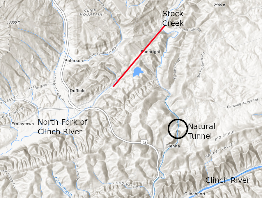
Stock Creek may have been the headwaters of the North Fork of the Clinch River flowing towards modern Duffield (red line), before stream piracy diverted it and led to formation of Natural Tunnel (black circle)
Source: ESRI, ArcGIS Online
According to current geological interpretation, the Glenita Fault had created zones of weaker rock crushed during the Alleghenian Orogeny. Carbon dioxide dissolved in the rainwater made it slightly acidic, and carbonic acid etched away at the limestone and dolomite along the fault. The collapse of underground cavities led to sinkholes on the surface.
One sinkhole may have diverted Stock Creek to the south, leaving Tunnel Gap as a dry "wind gap." After the initial stream piracy, Stock Creek then may have carved the gap through Purchase Ridge now used by Route 871.
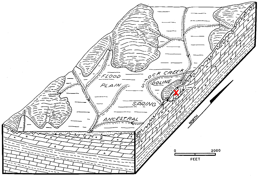
Stock Creek flowed across the surface long enough to carve a gap through Purchase Ridge, before creating Natural Tunnel (red X)
Source: Virginia Department of Energy, Geology of Natural Tunnel State Park
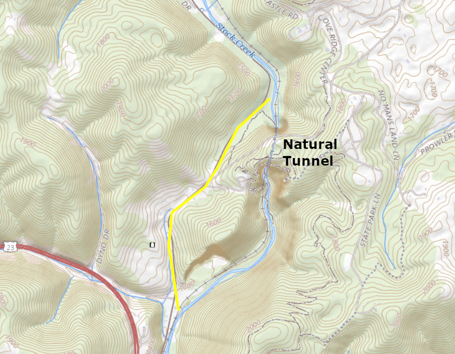
Stock Creek carved a gap now used by Route 871 through Purchase Ridge (yellow line) before creating Natural Tunnel
Source: ESRI, ArcGIS Online
At some point, Stock Creek quit flowing on the surface and all the water traveled underground. What had once flowed through the valley now used by Route 871 was pirated again. It began to take a more-direct route to the Clinch River, sinking underground at what is now the North Portal and emerging as a large spring at what is now the South Portal. The water flowed from the southern sinkhole to the Clinch River via a tributary that is now the lower end of Stock Creek.
According to this interpretation, the two sinkholes along the pirated route of Stock Creek expanded and then collapsed. The collapse exposed the North Portal and South Portal, and showed how they are connected by the underground channel now known as Natural Tunnel.4
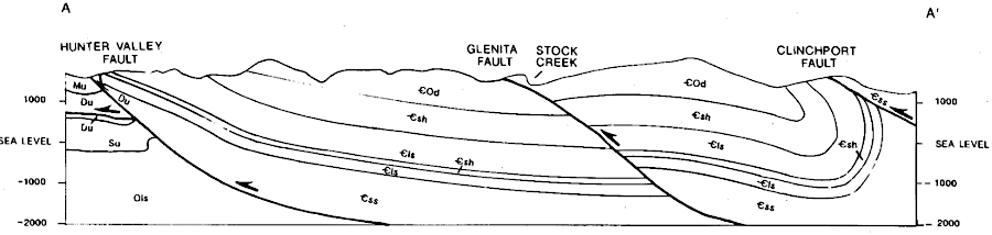
the weak zone of bedrock created by the Glenita Fault led to the creation of Natural Tunnel in Scott County
Source: Virginia Department of Energy, Geology of Natural Tunnel State Park (Figure 5b)
Between Ice Age intervals, when drainage through the underground channel was slower than the runoff into Stock Creek, the upstream valley would have become a lake. Remnants of the sediments that accumulated still remain in the valley of Stock Creek.
As described by the Virginia Department of Energy:5
The tunnel is 763 feet long if measured in a straight line from portal to portal. The curved railroad tracks through the tunnel are 838 feet in length, and Stock Creek travels over 900 feet underground. The tunnel is, on average, 100 feet wide and 50 feet high.
Continued erosion will eventually destroy Natural Tunnel, but that process will occur over geologic time measured in thousands of years.6
In 1852, the proposed Virginia & Kentucky Railroad identified a route from Bristol to Cumberland Gap that would pass through Natural Tunnel. In 1890, the South Atlantic & Ohio Railroad actually built track from Bristol to Bristol to Big Stone Gap, to access the coal deposits in Wise County. The railroad crossed underneath Purchase Ridge by using the natural tunnel.
After 1899 the Virginia & Southwestern Railroad was in control, and it advertised the "Natural Tunnel Route" for passengers Between 1906-1982 the track was owned by the Southern Railway, which ended passenger service along the route in 1939. The Norfolk Southern assumed responsibility in 1982. The CSX Railroad has trackage rights, and CSX coal trains also pass through Natural Tunnel.7
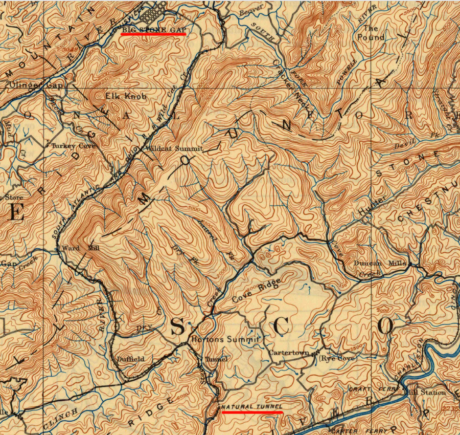
Natural Tunnel provided the railroad an easier connection between Bristol and the Wise County coal fields near Big Stone Gap
Source: US Geological Survey (USGS), Estillville KY 1:25,000 topographic quadrangle (1894)
The Natural Tunnel Chasm and Caverns Corporation made the site a tourist attraction in 1928. The Commonwealth of Virginia acquired the tunnel and 100 acres of land from that corporation in 1967, and then purchased an additional 850 acres. The railroad retained the right to use the tunnel for trail traffic.
Natural Tunnel State Park opened in 1971. A chairlift connecting the visitor center to the South Portal was constructed in 1989, to provide easier access than the hiking trail down to Stock Creek. An overlook at he South Portal provides a view of one end of the tunnel. On occasional "Railroad Days," the state park will make arrangements so no trains will go through the tunnel and visitors can walk safely along the underground tracks.8
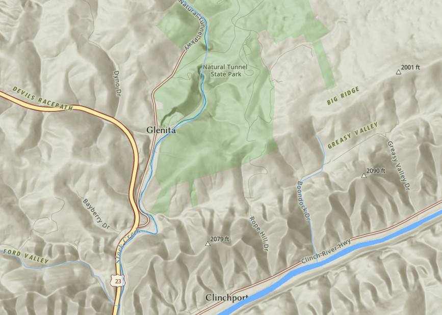
Stock Creek, a tributary of the Clinch River, flows through Natural Tunnel
Source: ESRI, ArcGIS Online
tracks of the Norfolk Southern Railroad also pass through Natural Tunnel
Source: US Geological Survey (USGS), Clinchport VA 1:24,000 scale topographic quadrangle (2019)
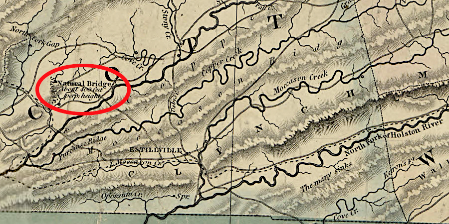
the tunnel was still called "Natural Bridge" just before the Civil War
Source: Library of Congress, A map of the state of Virginia, constructed in conformity to law from the late surveys (Ludwig von Buchholtz, 1859)