
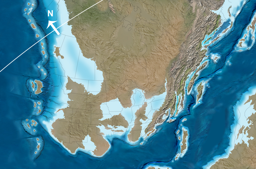
the Iapetus Ocean formed when the supercontinent of Rodinia rifted apart
Source: Dr. Ron Blakey, Paleogeography and Geologic History of North America
the Iapetus Ocean formed when the supercontinent of Rodinia rifted apart
Source: Dr. Ron Blakey, Paleogeography and Geologic History of North America
During the Cambrian period, parts of Rodinia continued to separate. The Iapetus Ocean started to form 570 million years ago, as the continental plates drifted apart.
Along the shoreline of Virginia, the sea level was higher or the land dropped, and the Catoctin lava flows ended up underneath the water of the Iapetus Ocean. Sediments washed off the continent to the ocean, forming beaches on the shoreline. Offshore, layer after layer of sediments settled out from whatever rivers were eroding the North American tectonic plate. Those sediments settling underwater created a continental shelf of mud and quartz (silica) sand, also burying the Catoctin lava flows.
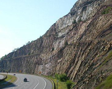
The Catoctin basalts were buried by those sediments, in layers now known as the Chilhowee Group. Those sediments (now metamorphosed) are exposed along I-66 at Thoroughfare Gap, and near Front Royal at Manassas Gap. The different sizes of sand particles in the sediments document the changing elevation of the mountains that contributed the sediments.
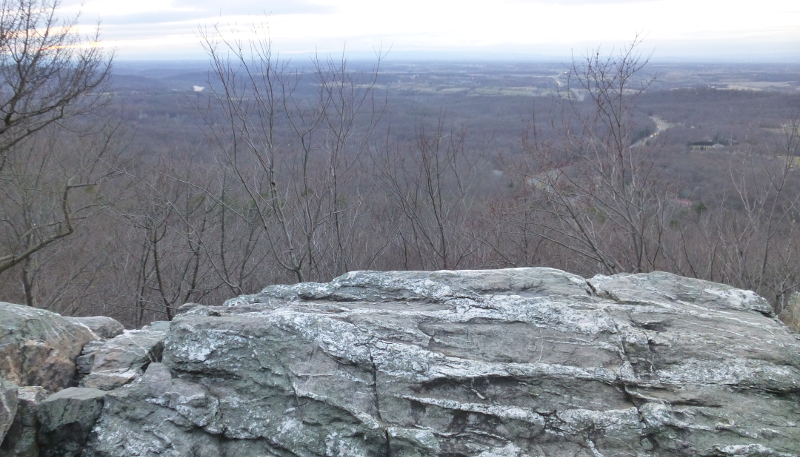
sediments in the Chilhowee Group buried the Catoctin lava flows roughly 500 million years ago, but those sediments are now exposed and offer vistas of Fauquier County from the top of the Bull Run Mountains at Thoroughfare Gap
The Weverton Formation, the first layer within the Chilhowee Group lying on top of the Catoctin lava flows, is composed of relatively large sand particles. As the mountains eroded to a lower level - or sea level rose to create a deeper water body - rivers eroding the land had less energy, and sand particles were deposited closer to the edge of the continent. Smaller particles were still pushed offshore, and sediments deposited on top of the Weverton sandstone were tiny pieces of mud and silt.
Those smaller mud and silt particles form today's Harpers Formation. On top of the Harper's Formation are larger particles, the Antietam Formation of sand-sized particles comparable to modern barrier islands on the Eastern Shore and at Cape Hatteras. The changing size of sedimentary particles provides key clue to when sea levels were changing, mountains were eroding to lower levels, or tectonic forces were uplifting mountains and added elevation provided enough energy for larger sand particles to be carried further offshore.
After deposition of the Antietam Formation, the basement/volcanic rocks and the sediments on top of them ended up underneath a deeper part of the Iapetus Ocean. Zillions of tiny marine sea creatures with tiny shells of limestone lived and died in the waters on top of the buried stack of rocks. After the sea creatures died, their tiny shells drifted to the ocean bottom and formed an ooze of limey mud on top of the Antietam Formation.
More and more sediments of shells accumulated, covered by chemically-precipitating lime and an occasional layer of mud and sand (after major storms onshore created spectacular erosion). The sedimentary layers compacted and the tiny individual shells merged into thick beds of limestone (calcium carbonate) and dolomite (calcium magnesium carbonate). If you go to the Bahamas and the Caribbean, you can the same process happening today forming a "carbonate bank." (Another option: keep adding spoon after spoon of sugar to your Cheerios, and see the grains accumulate on the bottom of the bowl.)
While underneath the Iapetus Ocean, as much as 25,000 feet of limestone sediments accumulated on top of the Virginia basement rocks in the early days of the Paleozoic Era, primarily during the Cambrian and Ordovician periods. Virginia was covered by a shallow ocean. The basalts and Grenville rocks were pressed down and metamorphosed, perhaps creating at this time the mineral "epidote" that gives the Catoctin basalts their particular greenish color.
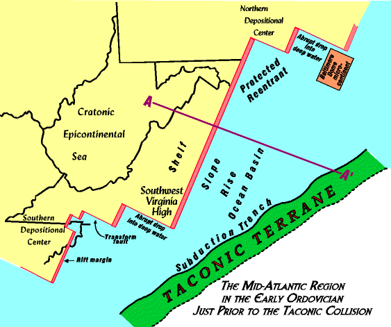
during the Taconic Orogeny, a volcanic island chain was added to Virginia
Source: The Geological Evolution of Virginia and the Mid-Atlantic Region, The Ordovician Taconic Orogeny And Martinsburg Flysch and Queenstone Clastic Wedges
Now comes the good part. The Iapetus Ocean did not grow steadily; the accumulation of limestone sediments did not end the story.
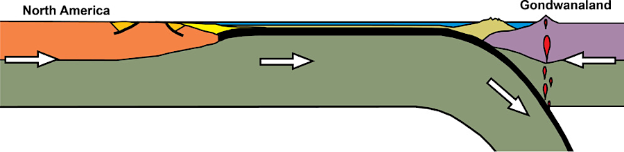
For whatever reason, the continental plates reversed direction. Africa and North America started to move together again, and the Iapetus Ocean began to close. The bottom of the ocean buckled, and one continental plate slid underneath the other.
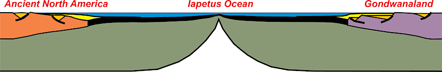
the Iapetus Ocean separated Laurentia (Ancient North America) and Gondwanaland before three major orogenies finally formed Pangea about 275 million years ago
Source: National Park Service, Tectonic Evolution of the Southern Appalachian Mountains - 500 Million Years Ago
Ultimately, the Iapetus Ocean closed completely, and Africa crunched into Virginia and the rest of eastern North America. That merger of continental plates occurred in three major collisions that formed mountains: the Taconic, Acadian, and Alleghenian orogenies. In those three times, Cheerios merged together.
The Taconic Orogeny, roughly 460 million years ago during the Ordovician Period, involved volcanic island chains in the Iapetus Ocean. Chunks of land equivalent to Japan or the Aleutian Islands today off the coast of Alaska were "rooted" to the ocean floor - but that ocean floor moved, and was subducted underneath the North American continental plate.
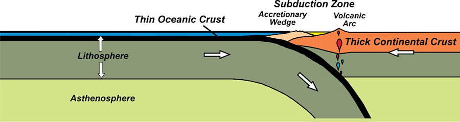
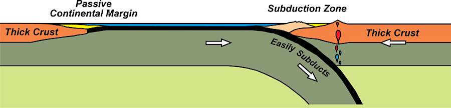
subduction is the process by which heavier oceanic crust is squeezed beneath lighter continental crust
Source: National Park Service, Collisional Mountain Range Development
When the Iapetus Ocean began to close and the ocean crust began to move towards North America, the volcanic islands were carried towards the continent too. One chunk, known today as the Chopawamsic Terrane, was shoved against continental edge. As the plates drifted and the Iapetus Ocean closed, a smaller and smaller gap existed between the shoreline of North America and North Africa.
Several island arcs and chunks of crust (micro-continents) existed in the gap between the two continents. The gap separating North America and the closest island arc (Indonesia is a modern island arc) was the Iapetus Ocean.
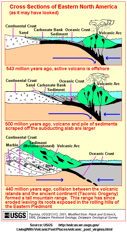
a chunk of volcanic crust merged with Virginia during the Taconic Orogeny, pushing up a mountain range in an "orogeny"
The limestone that accumulated on the edge of the North American plate, coating the Catoctin basalts and the Chilhowee Group above the igneous basement rocks, is exposed today throughout the Shenandoah Valley. Those formations developed in a quiet tectonic environment, with minimal sand or clay washing in from the continental crust, suggesting that the edge of the continent was flat.
However, the Iapetus Ocean was shrinking, and ultimately new sediments were added to the ocean floor. As the Iapetus Ocean floor was subducted underneath the North American plate, volcanic ash was blown in from the approaching islands, and mud washed from the mountainous islands onto the ever-shrinking seafloor. As the ocean closed, the depth and chemistry of the water changed. Ultimately mud, sand, and volcanic debris from the islands covered the bottom; the remaining water was too shallow for creating more layers of lime-rich sediments.
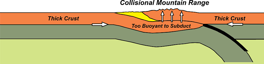
Finally, the first part of the ocean seafloor closed completely when one island arc collided or "docked" with the continent. The scrunching together of the island arc with the continental margin formed mountains perhaps as high as the Alps in Europe, in a mountain-building event known as the Taconic Orogeny.
(Try squeezing a balloon between your hands, and you can see it rise up higher and higher as the distance shrinks between the hands. That's what happened to the earth's crust - it rose higher into mountains, as the width occupied by the crust got smaller and smaller.)
The Taconic-time mountains, located east of the current Blue Ridge, were roughly 13,000 feet high. In the vegetation-free Ordovician Period 450 million years ago, erosion of those mountains would have been immense and rapid. As the chunks of continental crust collided, land was uplifted but rushing rivers carried sediments away.
Erosion finally won the battle. The Taconic-time mountains in what would become Virginia were flattened, and the rivers spread the eroded sediments horizontally in flat layers. As the Taconic-time mountains eroded to near sea level, a "clastic wedge" known as the Queenston Delta formed in what is now West Virginia and western Pennsylvania. In southwestern Virginia, erosion from another section of the Taconic-time mountains formed the Blount clastic wedge, extending into Kentucky.1
As the mountains washed away and became lower lower lower, the energy in the rivers to move the rock lessened. The clastic wedges, formed by the eroding Taconic-time mountains, were capped by a final layer of quartz sand particles. The final sedimentary layer marks the last stage of natural mountaintop removal, when most of the topographic relief was gone and just the hard-to-dissolve quartz minerals remained.
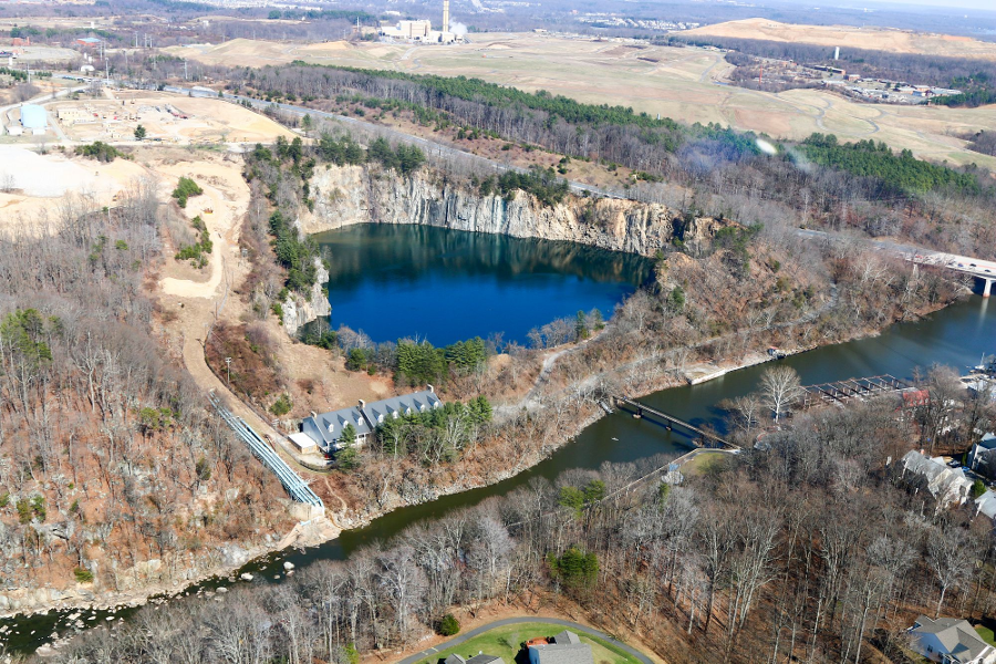
Vulcan's Graham Quarry on the Occoquan River has extracted granite from the mountains uplifted in the Taconic Orogeny
Source: Historic Prince William, Rock Quarry - #98
The sands were later compacted into sandstone, and the layer marking the end of the Taconic Orogeny is known today (depending upon your location) as the Tuscarora, Clinch, or Massanutten sandstone. After being buried by other sediments, that sandstone is exposed on the surface again. It is visible today as the slow-to-erode bedrock that forms many of the Appalachians ridges, including the eastern and western ridges of Massanutten Mountain.
Virtually the last erosion from the island arc in Taconic-time was iron-rich sediments deposited in the Silurian period. These Clinton/Cayugan deposits did not form thick layers; they were created when there was little relief and the high-energy, powerful rivers of the Ordovician period had been replaced by mild, meandering streams. The Silurian sediments deposited in patches by these streams were the sources for much of the Virginia iron industry in the 1800's.2
Source: USGS, What is Geologic Time?
At the same time the Silurian iron deposits were formed in sandstones, some areas were shallow seas where carbonate (limestone) sediments were deposited. There were a few zones where the water evaporated, and thick salt deposits developed.
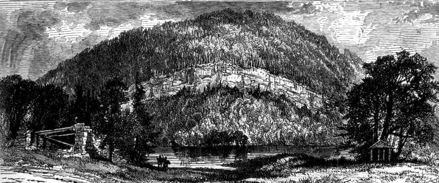
In the colonial era, before transportation of bulk commodities became relatively easy, these salt deposits were highly valued by pioneers and settlers in the mountains - and by the Confederacy in the Civil War. Before the railroad came to town, Roanoke was known as "Big Lick." Saltville relied upon its salt and gypsum deposits as the primary source of employment for over a century, until Tennessee's complaint about salt pollution affecting the drinking water of the Holston River finally forced closure of the factory.
Then came the Silurian period, the calm before the storm.
The Taconic Orogeny eliminated the Iapetus Ocean. Some of the basalt of the ocean floor and the island arc were added to North America during the Taconic Orogeny.

the Taconic Orogeny pushed up the Ancestral Appalachians where I-95 is located today
Source: Dr. Ron Blakey, Paleogeography and Geologic History of North America
The Rheic Ocean stretched from that island arc to the African plate, and after the Taconic Orogeny the Rheic Ocean still separated the North American tectonic plate from the African Plate.
Within the Rheic Ocean were other microcontinents and island arcs. As continental crust was subducted, the Rheic Ocean also got smaller in a pattern similar to the disappearance of the Iapetus Ocean.
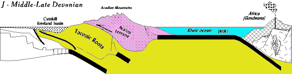
In the Devonian Period, a second island arc known as the Armorica terrane docked against the North American Plate. That triggered the Acadian orogeny, and the rocks of Virginia record a second sequence of ocean sedimentation shifting to mountain-building and finally erosion.
island arcs in the Iapetus Ocean were accreted onto the edge of Laurentia in the Taconic and Acadian orogenies
Source: National Park Service, Tectonic Evolution of the Southern Appalachian Mountains - 400 Million Years Ago
The oldest rocks in the sequence are low-energy carbonates deposited in shallow seas (or on a continental shelf) before the Rheic Ocean closed. On top of them, as the Armorica terrane approached, erosion and volcanic eruptions deposited black shales and volcanic material. A chunk of land, now called Avalonia, was pushed onto the edge of Virginia, expanding the width of the North American plate and creating a new mountain range.
Just like the Taconic-time mountains, the Acadian-time mountains washed away. Thick wedges of sediments (the Catskill delta) eroded from the Acadian-time mountains. Once again, a final layer of relatively-pure sandstone was deposited at the end of the cycle, after everything else has washed away and the mountain range was becoming a flatland. Just as the deposition of the Tuscarora/Clinch/Massanutten sandstone marks the end of the Taconic orogeny, the deposition of the Oriskany sandstone marks the end of the Acadian orogeny.
the Acadian Orogeny added a chunk of crust (a "terrane") to Virginia, extending Virginia beyond the Taconic chunk
Source: The Geological Evolution of Virginia and the Mid-Atlantic Region, The Devonian Acadian Orogeny And Catskill Clastic Wedge
The Acadian orogeny, like the Taconic, widened the North American continent. The "terranes" or island arcs that docked onto the shores of Virginia extended North America east of the Grenville-age Blue Ridge, as well as increased the depth of the younger sediments that eroded to the west and the east. The arrival of Avalonia pushed the earlier-arriving Chopawamsic Terrane further west, adding more heat/pressure to alter the bedrock in the older terrane.
During these two orogenies, the modern-era Blue Ridge was buried deep beneath the surface. The rocks of the modern-era Blue Ridge were also 40 or so miles east of their current location. The peaks of the eroding Taconic-time mountains and the Acadian-time mountains were located roughly along the route of Interstate 95 today, while the buried Blue Ridge was just to the west... or underneath the Taconic-time and Acadian-time mountains.
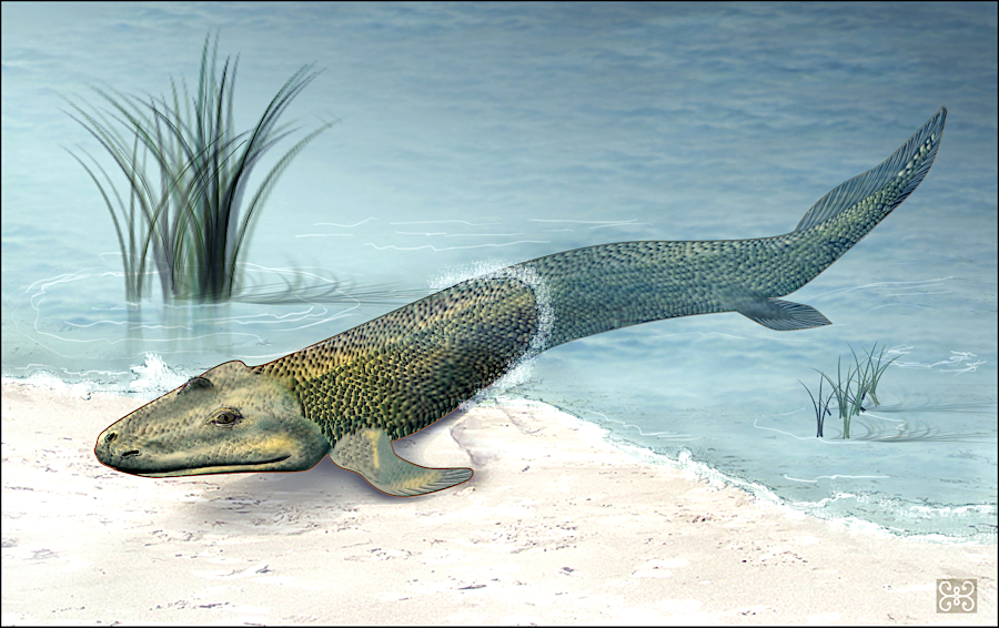
Tiktaalik roseae may have crawled onto land in Virginia 375 million years ago during the Devonian Period, as the Acadian Orogeny was depositing sediments in the Valley and Ridge Province
Source: National Sciemnce Foundation, Fossil Fish Tiktaalik roseae (by Zina Deretsky)
in the middle Devonian period 385 million years ago, between the Taconic and Neo-Acadian orogenies
Source: National Park Service, Convergent Plate Boundaries-Collisional Mountain Ranges (originally from Paleogeography and Geologic History of North America)
The third and last collision was different from the Taconic and Acadian collisions, which involved just small "terranes" of land. When Africa finally slammed into North America, it created the supercontinent of Pangea - and squeezed Virginia from the side. It is possible that the African plate slid inland and reached as far as the Allegheny Front - nearly the western boundary of Virginia. The pressure from Africa caused the rocks on the eastern side of Virginia to break free from their roots.
The eastern rocks pressured by Africa were folded and thrust, like a stack of slick Sunday newspaper inserts sliding off a table. Ocean sediments that were once east of Richmond ended up as metamorphosed Piedmont crystalline rocks at Charlottesville. The buried Blue Ridge was thrust 40-60 miles to the west. The sediments that had eroded off the Taconic-time and Acadian-time were folded and bent into anticlines and synclines, as the rocks layers reacted to the pressure of the collision.3
rocks layers in the Valley and Ridge province, folded by the collision with Africa
Picture a spectacular car crash in a Hollywood movie. One car bangs into another, and they both stop - and then a second car with a high bumper rams them, and slides up onto the trunk. Other cars and trucks come by, and ride over top of the smashed cars to create a tall stack. In the movie, as everyone scatters and the gas tanks begin exploding, a tractor trailer might roll in and climb halfway up the pile before pushing over the cars at the top. Forget the gasoline explosions, speed up the film so millions of years are compressed into a minute, and replace the layers of cars with layers of rocks.... and you have the Alleghenian orogeny, when Africa came calling.
In addition to breaking and thrusting the rocks on the coastline to the west, the energy of the collision with Africa wrinkled the layers of sediment as well. Those limestones and shales and sandstones from the Taconic and Acadian erosion cycles were folded, crumpled, and (close to the shoreline) broken.
at Rainbow Gap near Iron Gate, the James River has exposed how sedimentary layers were folded in the Alleghenian Orogeny
Source: "The Chesapeake & Ohio Railway Directory, Containing an Illustrated History and Description of the Road," Healing Springs (p.338)
In some cases the flat-lying layers of sediments cracked and lifted slightly, and then the eastern portion slid overtop the western part of the same layers. This doubled the thickness of the sediment layers and shrank the width of Virginia, while absorbing the energy of the collision. The width of Virginia may have been compressed as much as 200 miles.4
The African collision produced its own mountain range on top of all the Virginia rocks left behind earlier by the Grenville event, the Taconic orogeny, and the Acadian orogeny.. (Surely you have figured out by now that the solid earth is anything but static, and that "native Virginia soil" came from rocks that are constantly moving around the continent...)
Once again, all the drainages were rearranged by a new series of mountains. Only one river, known ironically as the New River, seems to have had the ability to continue to continue in its old channel, cutting across the rising Appalachian Mountains as the African continent wrinkled the surface into new ridges and valleys.
Virginia was in the middle of that supercontinent called Pangea, far from the seashore - similar to its location in Rodinia. Once again, 300 million years ago (just like one billion years ago), Virginia had a "continental climate."
On to: The Rest of the Story About Virginia Geology
Back to: The Grenville Event and Virginia Geology
after Rodinia split to form the Iapetus Ocean, sediments accumulated in thicker layers on the edge of the continent where embayments were low and in thinner layers where the crust as uplifted to form arches
Source: Geology of the National Capital Region - Field Trip Guidebook, Tertiary Lithology and Paleontology,
Chesapeake Bay Region
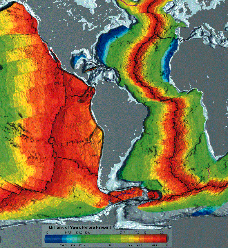
the oldest basalt at the bottom of the Atlantic Ocean is next to Virginia - and Morocco/Mauritania in Africa
Source: National Oceanic and Atmospheric Administration (NOAA), Age of the Ocean Floor