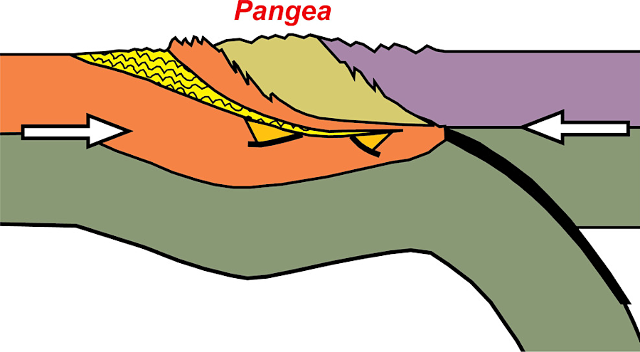
the collision of Laurentia with Gondwanaland formed the supercontinent Pangea about 275 million years ago
Source: National Park Service, Tectonic Evolution of the Southern Appalachian Mountains - 300 Million Years Ago
the collision of Laurentia with Gondwanaland formed the supercontinent Pangea about 275 million years ago
Source: National Park Service, Tectonic Evolution of the Southern Appalachian Mountains - 300 Million Years Ago
The short story: Africa (Gondwanaland) collided with North America (Laurentia) and created the supercontinent Pangea. Both Gondwanaland and Laurentia were formed of continental crust which had comparable density, so one continent was not subducted underneath another. Instead, their head-on collision crumpled and cracked the edges of both continents, creating th supercontinent.
The collision cracked the billion-year-old "basement", the bedrock formed in the Grenville Orogeny, and thrust slices of it westward. Today's Blue Ridge is one slice that was lifted up and shoved 40 or more miles to the west. The Blue Ridge, bedrock that was originally located near modern I-95, now sits on top of younger limestone sediments that were formed in the Iapetus Ocean 300-500 million years ago
The Alleghenian Orogeny about 275 million years ago involved massive forces that shoved blocks of crust upward, comparable to what happens on a smaller scale when two vehicles collide head-on. Mountains formed where the continents met, with solid rock shoved up by the pressure.
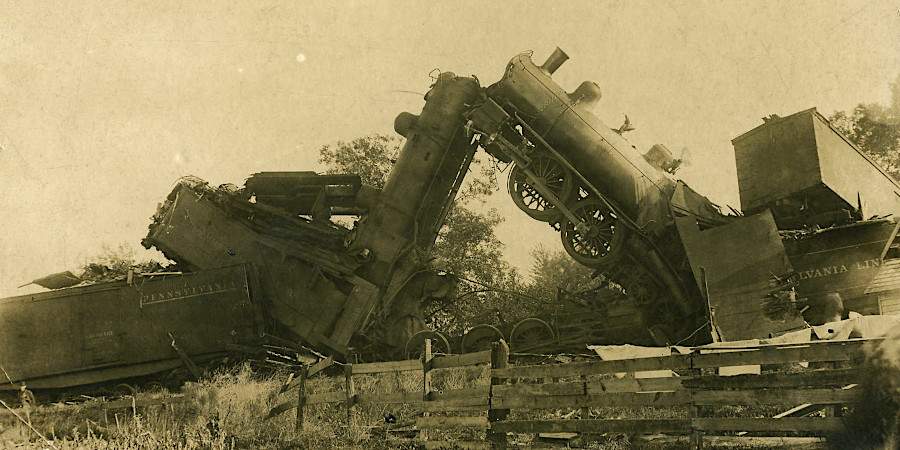
the collision of Laurentia-Gondwanaland thrust up mountains, similar to how vehicles are lifted up after a head-on collision
Source: Steve Shook, Head-on Wreck on the Panhandle Railroad, October 18, 1903 - Hebron, Indiana
But that is only part of the story. After the continents of Africa and North America merged and birthed the Appalachians, they divorced and went their separate ways.
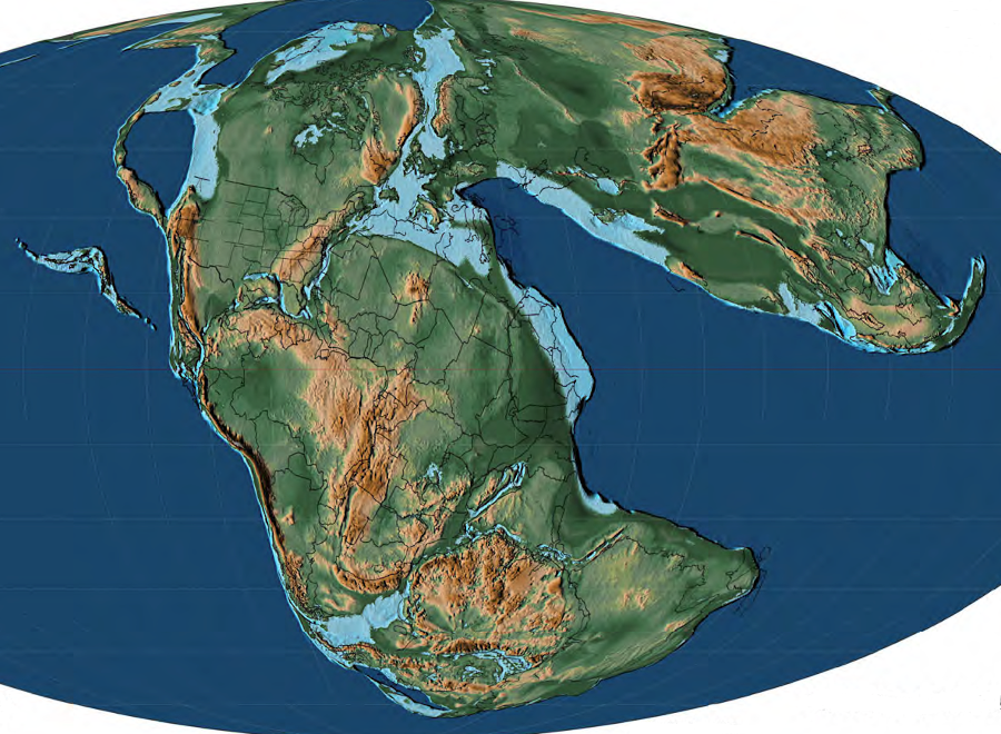
breakup of Pangea in the Early Jurassic, 179.3 million years ago
Source: C. R. Scotese, Atlas of Jurassic Paleogeographic Maps, PALEOMAP Atlas for ArcGIS, Atlas of Jurassic Paleogeographic Maps (Volume 4, Map 39)
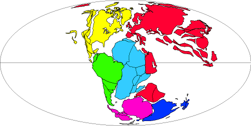
at the start of the Cretaceous Period about 150 million years ago, the Atlantic Ocean was getting larger as the Mid-Atlantic Ridge grew, and North America (in yellow) moved further away from Europe/Africa
Source: US Geological Survey (USGS), Color-coded Continents!
After the Appalachian (or Alleghenian) orogeny, the mountains that had been pushed up by the Africa-America collision eroded. To the west, the sediments filled up the middle of the North American continent in layer after layer.
They permanently raised the bed of the continent's center, after numerous large seas had inundated it previously and deposited limestones, coal, shale, and sandstones, to form the bedrock of Indiana, Illinois, Missouri. The mountains also eroded to the east, depositing sediments on what today is Morocco and Mauritania.
The supercontinent that formed after the African collision, known as Pangea, was unstable. The combined continental plates known as Rodinia had been unable to stay together after the Grenville event; heat trapped under the crust forced the breakup of Pangea.
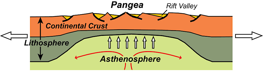
Pangea trapped heat, which finally forced the supercontinent to break apart again
Source: National Park Service, Continental Rift Diagram
About 225-200 million years ago, the tectonic stresses pulled Africa and North America in different directions again. Pangea developed a series of parallel cracks, those cracks became valleys where the crust thinned. The parallel cracks filled with sediments eroding off the Appalachians, and are known today as Triassic Basins.
In addition to sediments washing in from above, the thinning crust allowed basalt lava to erupt into the cracks from far below. Modern geologic maps reveal long line of "dikes" and "sills" of igneous rock which intruded the metamorphic rock of the Piedmont. Those lines run north-south, perpendicular to the east-west stretching of the North American Plate as Africa and North America pulled apart.
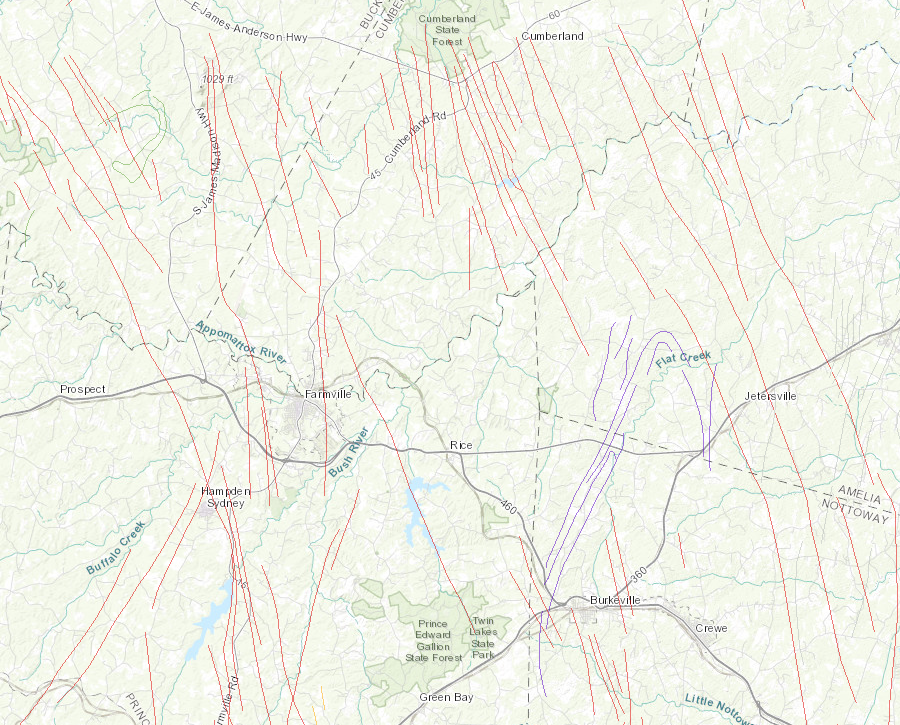
dikes around Farmville reveal where igneous lava intruded into cracks in the crust that was stretched as Pangea split up
Source: Virginia Department of Mines, Minerals and Energy (DMME), Interactive Map of Virginia's Geology and Natural Resources
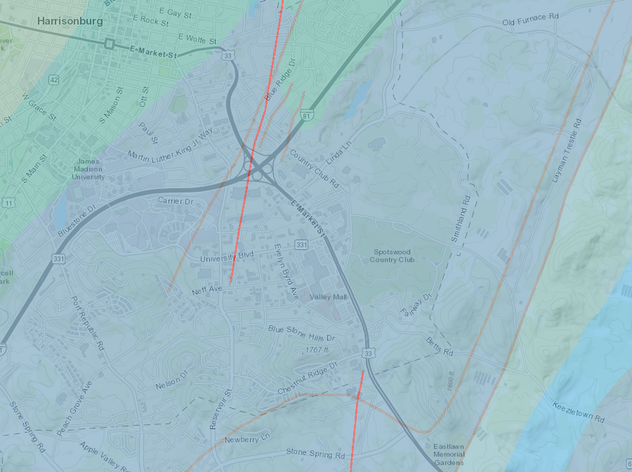
thrust faults (orange lines) near Harrisonburg date to Alleghenian Orogeny, while diabase dikes (red lines) date to split of Pangea in Triassic Period
Source: Virginia Department of Mines, Minerals and Energy (DMME), Interactive Map of Virginia's Geology and Natural Resources
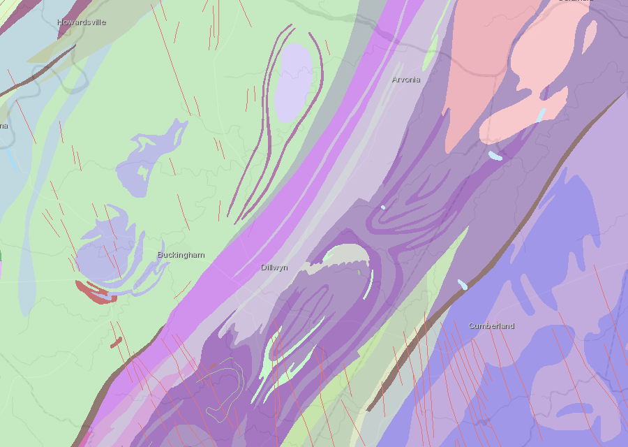
diabase dikes (red lines) from the Triassic Period appear in Proterozoic - Cambrian formations south of the James River
Source: Virginia Department of Mines, Minerals and Energy (DMME), Interactive Map of Virginia's Geology and Natural Resources
One particular crack in the crust of Pangea became the primary release point for the heat to escape. A rift valley with a "spreading center" formed, and the continents split apart along that seam.

a much-smaller Atlantic Ocean 170 million years ago separated what became Virginia and Morocco
Source: Dr. Ron Blakey, Paleogeography and Geologic History of North America
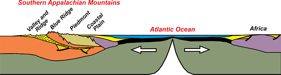
This major rift continued to grow a few inches per century. Sediments continued to flow into this particular crack from the east and the west, but the rift valley deepened faster than erosion could fill it. The rift valley finally grew so wide that it forced the continents completely apart - and as the salt water flowed into the valley, the Atlantic Ocean was born.
Initially the Atlantic Ocean was only a narrow strip of salt water, but once again Virginia was a coastline state and no longer trapped in the center of a supercontinent. Where topographic relief was lower, such as at the mouths of rivers, mudflats/beaches were created. Some eroded sediments from the Appalachian Mountains settled in the ocean to coat the Continental Shelf.
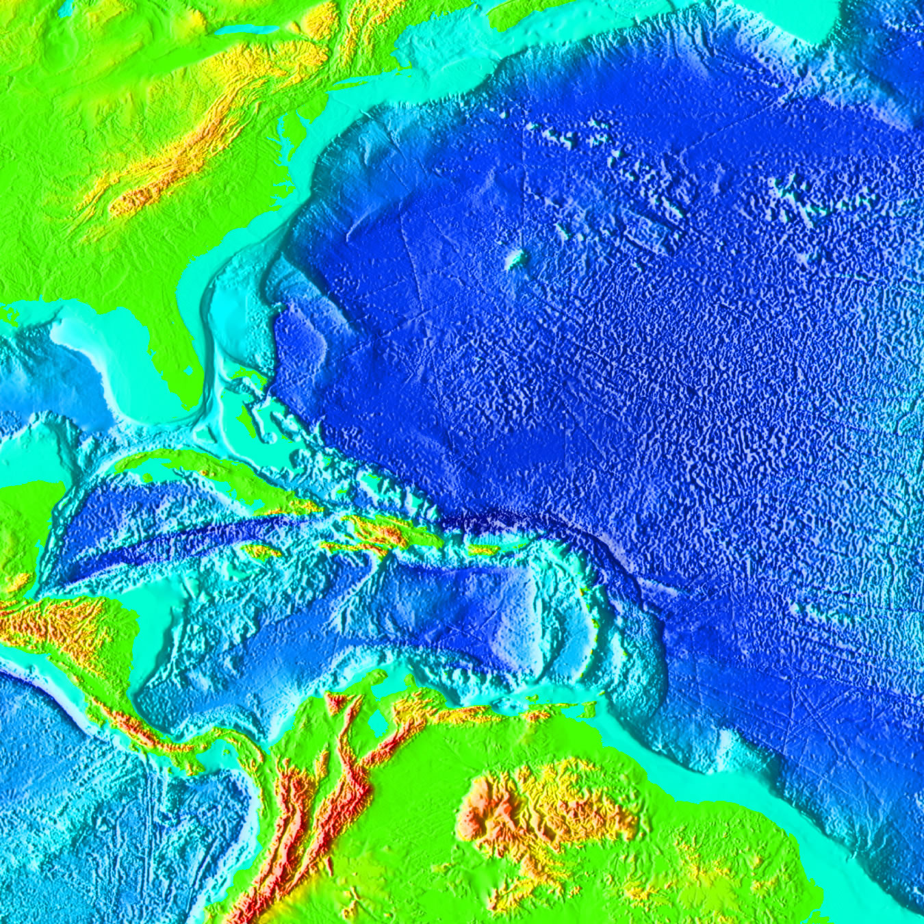
sediments eroding off Virginia's mountains for 300 million years have created a Coastal Plain and Continental Shelf, east of the Piedmont
Source: National Oceanic and Atmospheric Administration (NOAA), Surface of the Earth (ETOPO2v2) 2 minute color relief images
Over time, several thousand miles of lava built up between the still-erupting rift (known now as the Mid-Atlantic Ridge) and those North American sediments. The oldest Atlantic Ocean seafloor, basalt lava extruded about 180 million years ago, is adjacent to the Outer Continental Shelf off Virginia.
The bottom of the Atlantic Ocean continues to grow as the North American plate - carrying Virginia with it - drifts westward away from the Mid-Atlantic Ridge at slightly less than 1 inch/year. Coincidentally, the moon is moving away from the earth at 1.5 inches per year.
Since Africa and Europe are also moving away from the Mid-Atlantic Ridge at the same speed, an airplane flying from Dulles to Paris will have to travel about an extra two inches every year. By comparison, human hair grows 4-6 inches/year. Fingernails grow slower at a rate of about 1.5 inches/year, and toenails grow at about 0.5 inches/year.1
lava emerging from the Mid-Atlantic Ridge has pushed Africa and North America apart - or have the tectonic plates moved from other causes, and lava simply rises to fill the gap?
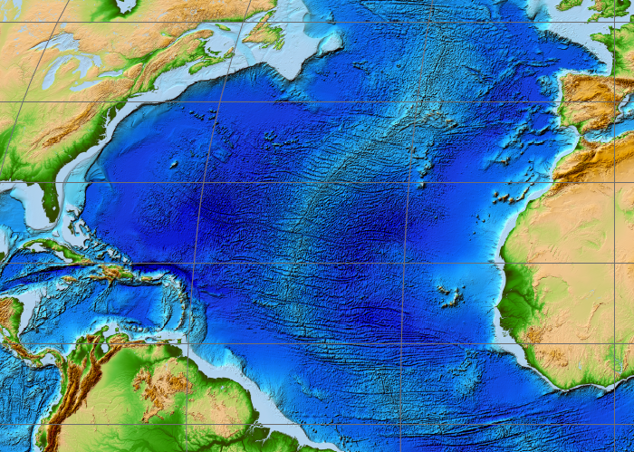
Source: National Oceanic and Atmospheric Administration (NOAA), ETOPO1 Global Relief Model
the Atlantic Ocean seafloor has grown, east and west of the Mid-Atlantic Ridge, for 180 million years since Pangea split apart
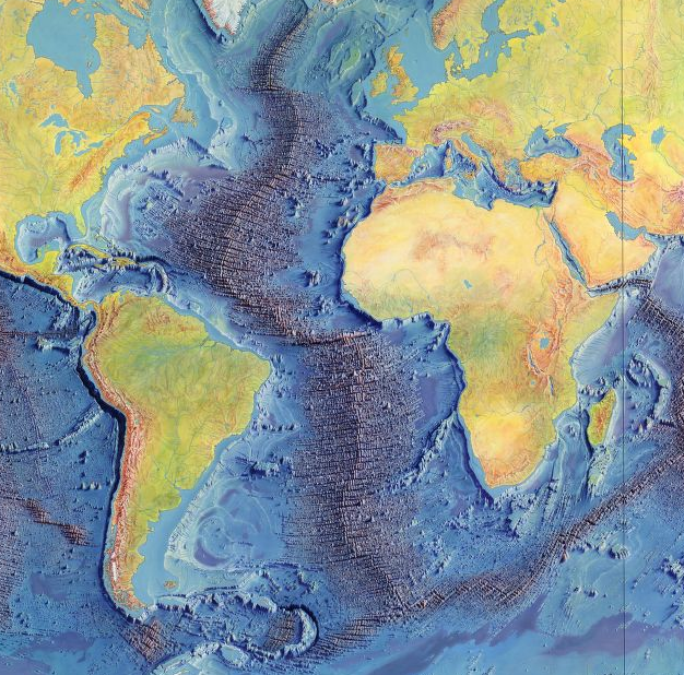
Source: Library of Congress, Manuscript painting of Heezen-Tharp "World ocean floor" map by Berann
On the eastern edge of the continent, along the new Atlantic Ocean, the sediments have created both a massive new Continental Shelf in the Atlantic Ocean and a Coastal Plain east of Interstate 95. Those 200 million years of sediments sit on top of the ancient, now-metamorphosed rock layers that were once chunks of continental crust and were compressed into the Piedmont in three orogenies, as the Iapetus Ocean closed.
Virginia's rivers have created a wide trail of eroded dirt - the Coastal Plain - as the North American Plate drifts to the west, like a wedding dress trailing behind a bride going down the aisle. Not all Virginia rivers drain to the east. Some sediments went down the New River drainage to the Gulf of Mexico, helping to form the birdsfoot delta of the Mississippi River.
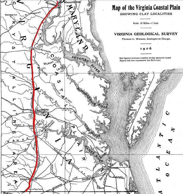
the Coastal Plain is east of the Fall Line, where soft sediments cover the crystalline bedrock
Source: Geological Survey of Virginia, The Clay Deposits of the Virginia Coastal Plain, Map of the Virginia Coastal Plain (1906)
The Alleghenian or Appalachian Orogeny is typically credited with forming the Appalachian Mountains, but the original "old" Appalachians are different from the ridges in West Virginia that we see today. The "old" mountains created 275 million years ago were located east of the modern Blue Ridge; the Ancestral Appalachians existed roughly along the route of I-95 today. Those ancient mountains have long since eroded away.
As rivers carried the "old mountains" away, sediments that flowed westward were transported away by the ancestral New, St. Lawrence River, and Mississippi rivers. Those sediments ended up being reburied in estuaries far from Virginia.
Some sediments flowed eastward. As Pangea cracked up, erosion carried them to the emerging Atlantic Ocean. Particles eroded from the Ancestral Appalachian mountains that reached the ocean shoreline were deposited on top of the exposed one-billion-year old Grenville basement. Sediments dating back 120 million years, when dinosaurs were walking across the landscape, are deeply buried at the bottom of the Coastal Plain and described as the Potomac Formation today. However, there are some exposures of the Potomac Formation along the Fall Line.
The modern Appalachians, what we see in the 21st Century, were uplifted more recently. The ridges and plateaus in the modern Appalachians are not the remains of the "old" mountains uplifted in the Taconic, Neo-Acadian, and Alleghenian orogenies, and gradually worn down since then. The modern Appalachians are created from the rock that was in the old Appalachians, but today's topography has a separate history.
The modern Appalachians include sedimentary and sandstone formations from particles that eroded off the ancient Appalachians uplifted 275 million years ago in the Alleghenian/Appalachian Orogeny. Those particles were once buried deep below more-recent sedimentary formations, but have been exposed as rivers gradually washed away the younger overlying layers.
In the Alleghenian Orogeny, slices of bedrock were broken apart, lifted up, and thrust on top of other slices. The formations east of the Allegheny Front were folded into anticlines and synclines, exposed today in the Valley and Ridge physiographic province as hard sandstone ridges separated by valleys underlain with softer limestone and shale.
West of the Allegheny Front, the energy of the Alleghenian Orogeny was exhausted and the sedimentary formations were not folded. The Appalachian Plateau in West Virginia and Kentucky has valleys and ridges, but those were formed by the rivers carving channels where joints and faults had created weak zones in the flat-lying formations.

west of the Allegheny Front, rivers carved valleys into the flat-lying sediments that had eroded off the mountains uplifted by Taconic, Neo-Acadian, and Alleghenian orogenies
Source: Ray Sterner, Color Landform Atlas of the United States
The modern Appalachian Plateau was uplifted recently, perhaps as the tectonic plate shifted direction in the last 50 million years. Tectonic pressures since the extinction of the dinosaurs have pushed up the remnants of the "old" mountains. The uplift exposed sediments dating back to the Taconic Orogeny nearly 450 million years ago. The rock formations are old, but storms in the last 50 million years (and perhaps far more recently...) are responsible for carving the current landscape. The scenic ridges and valleys west of the Allegheny Front, the hollows and ridges of Kentucky and Wes Virginia, are modern topographic relief etched into old rocks.
A hard metamorphic and volcanic slice of Grenville-age rock cracked and thrust westward by the collision with Gondwanaland/Africa, known today as the Blue Ridge, has been exhumed by erosion. It is exposed in its new location because softer rocks around that Blue Ridge slice have eroded away faster than the basement gneiss and Catoctin greenstone.
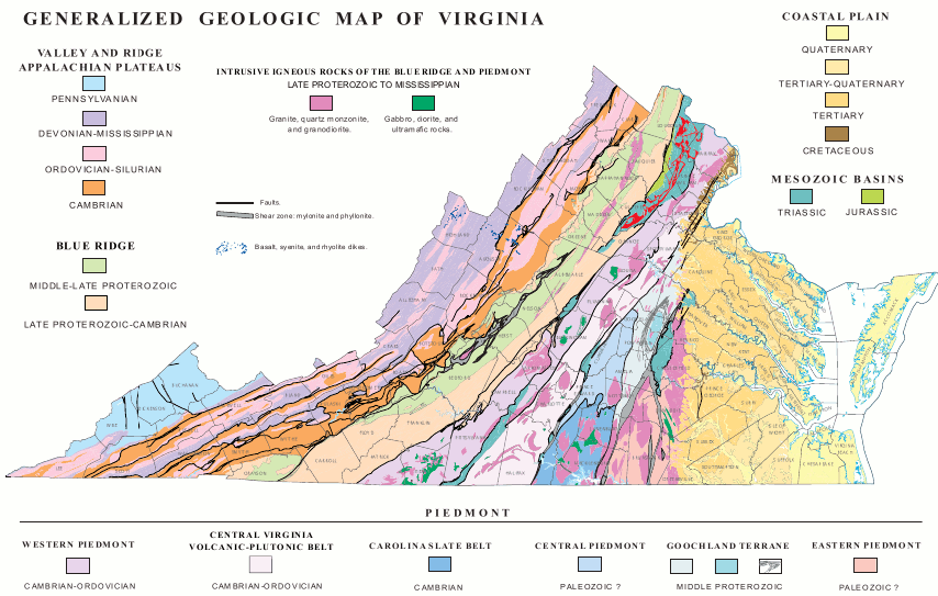
bedrock in different physiographic provinces was formed by multiple orogenies, then compression by the collision with Gondwanaland about 275 million years ago
Source: National Park Service, Tectonic Evolution of the Southern Appalachian Mountains - "Today"
Mount Rogers, with its hard volcanic rock laid down 600-700 million years ago when the supercontinent of the Grenville orogeny split up, has become the highest point in Virginia also because of differential erosion. The hard sandstones deposited after each orogeny, such as the Clinch Formation deposited at the end of the Taconic orogeny, have become the higher ridges of the Appalachian mountains.
Softer shales and limestone formations have eroded relatively fast. Today they form the low valleys to the west of the Blue Ridge; more-resistant sandstone formations have formed the ridges in the Valley and Ridge physiographic province. The Shenandoah Valley as developed because the Cambrian and Ordovician limestones there have eroded away faster than the volcanic Blue Ridge to the east, or the quartz-rich North Mountain to the west.
Differential erosion has created Virginia's modern topography. Rock formations that erode fast become valleys over time; formations that erode slowly become mountains. Over 50 million years, all the different formations should erode ultimately into a flat peneplain - except uplift from tectonic squeezing resets the clock, and uplift creates a new set of plateaus and mountains to be eroded away.
In the middle of the Shenandoah Valley, some layers of quartz-rich rocks have not disappeared yet - but Massanutten Mountain is gradually eroding away. Its presence shows the relative resistance of sandstone, compared to the softer carbonate rocks to the west and in Page Valley to the east of Massanutten.
Spectacular mountains have been created and eroded away three times, and maybe more, in Virginia. In the Eocene Epoch, tectonic shifts caused a brief renewal of volcanic activity in what today are Rockingham and Highland counties. Trimble Knob and Mole Hill are remnant volcanic plugs from that time, 35-48 million years ago.
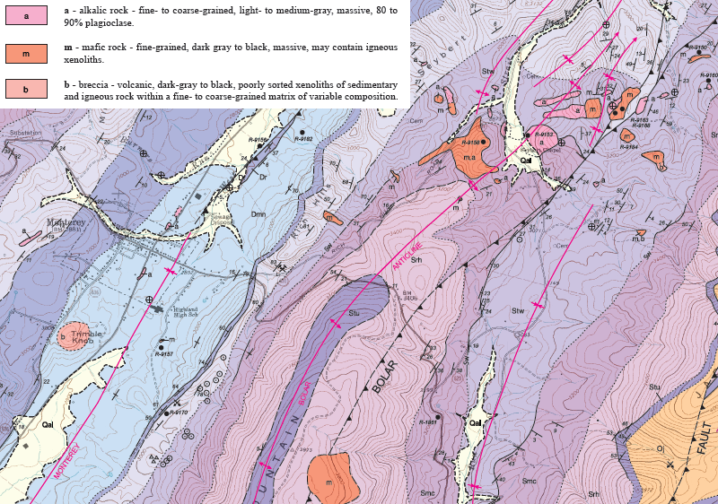
Eocene volcanics west of Harrisonburg and Staunton are evidence of the last volcanic activity in Virginia
Source: Virginia Department of Mines, Mineral, and Energy, Geology Of The Monterey Quadrangle, Virginia (Publication 178)
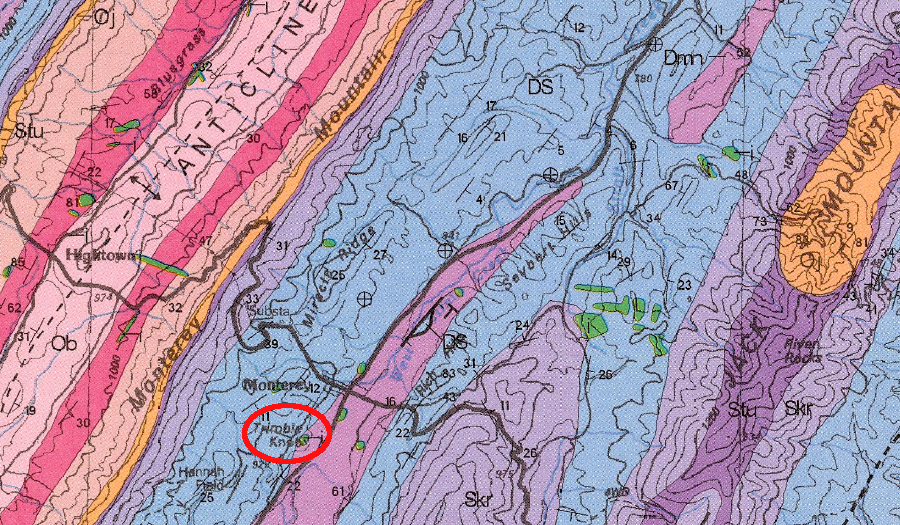
Trimble Knob is one exposure of volcanic intrusions (green polygons) in the Valley and Ridge physiographic province during the Eocene Epoch
Source: Virginia Department of Mines, Minerals and Energy, Geologic Map of the Virginia Portion of the Staunton 30 X 60-minute Quadrangle (Publication 163)
You can see the roots, and the ruins, of those events if you look at the rocks outside your car window and in your backyard. Erosion 0n the hillsides and by rivers etching away at the current Virginia landscape are just a gentler, kinder version of the tremendous tectonic forces that have raised and destroyed mountains as large as the Alps in Virginia.
Virginia today is the result of a billion years of rock creation, uplift, erosion, and deposition - and much pushing and pulling
Source: Virginia Department of Mines, Minerals and Energy
highway construction alters topography and invites erosion until vegetation grows on roadcuts
Source: National Archives, Silage Cutter and Blower in Operation (1950)
The North American tectonic plate continues to move, as do the other plates. One speculation is that a new supercontinent, equivalent to Pangea and Rodinia, could form in 200 million years. All plates except Antarctica would consolidate again in the Northern Hemisphere near the North Pole to form "Amasia."
Other calculations suggest a consolidation of tectonic plates to create an "Aurica" supercontinent could occur around the equator in 250 million years.2
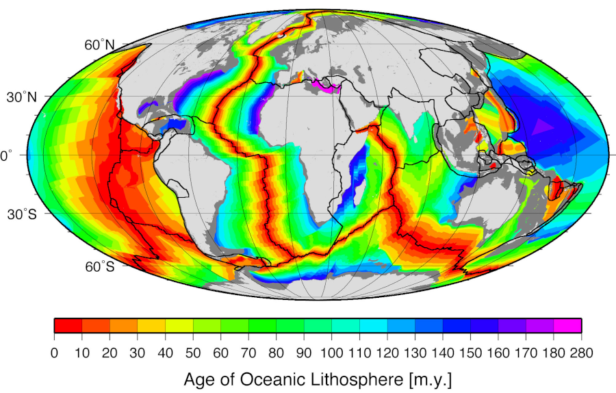
the oldest part of the Atlantic Ocean seafloor (about 180 million years old) is adjacent to the Virginia coast
Source: National Oceanic and Atmospheric Administration (NOAA), Age, spreading rates and spreading symmetry of the world's ocean crust
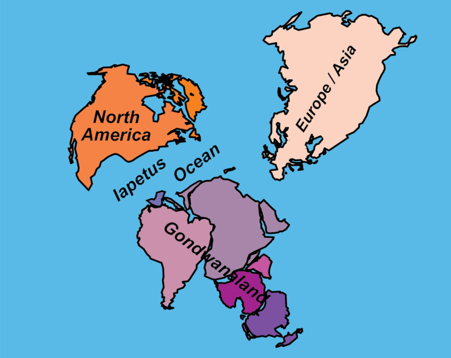
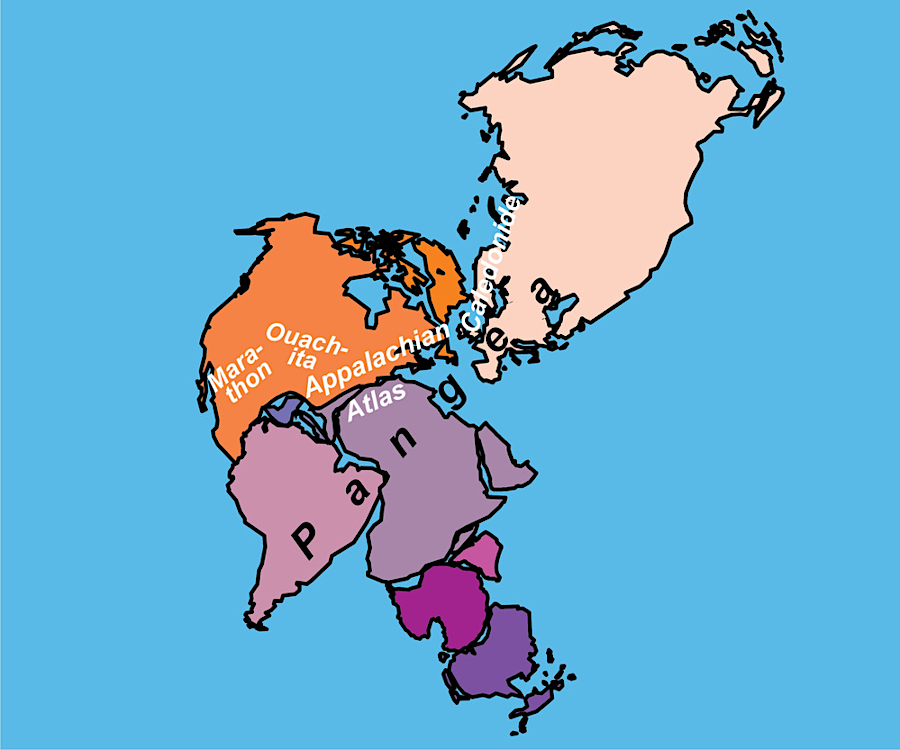
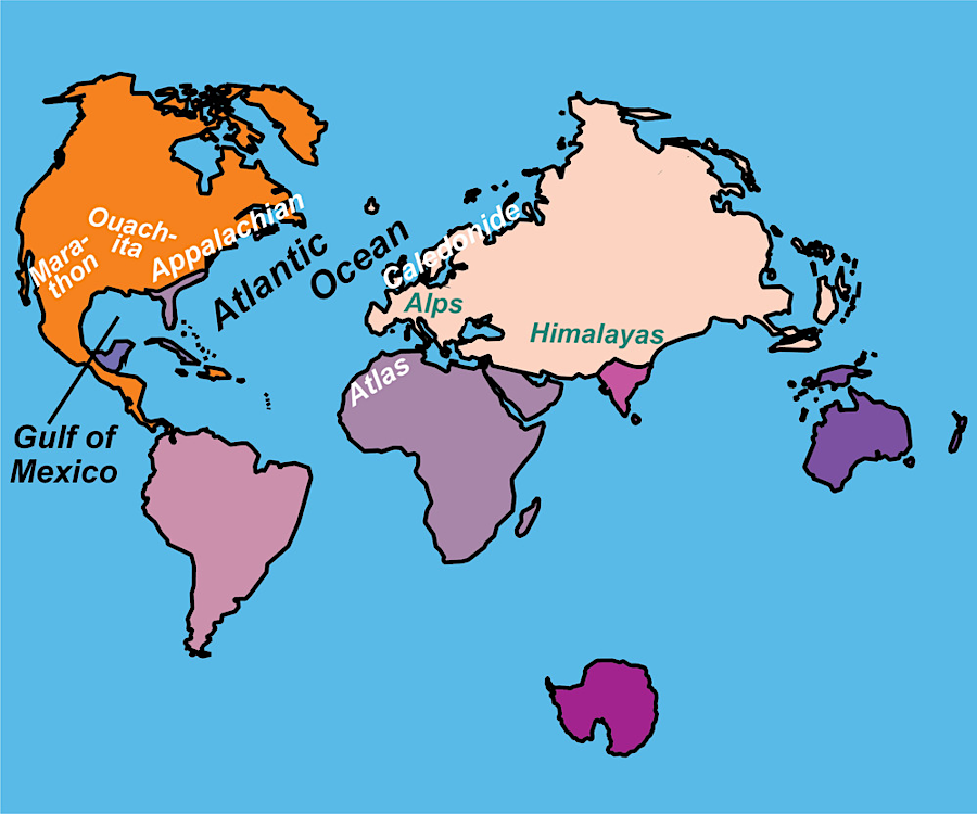
the collision of Africa and North America eliminated the Iapetus Ocean, and the breakup of Pangea then created the Atlantic Ocean
Source: National Park Service, Tectonic Development of the Appalachian—Ouachita—Marathon Mountain Range