The tide on the Virginia coast rises and falls about 1-4 feet twice a day at the NOAA reference stations. Development along the shoreline is based on those predicted tides, plus potential high water and waves from a flood that has a 1% chance of occurring each year (the "100-year flood") or from storm surges from major hurricanes.1
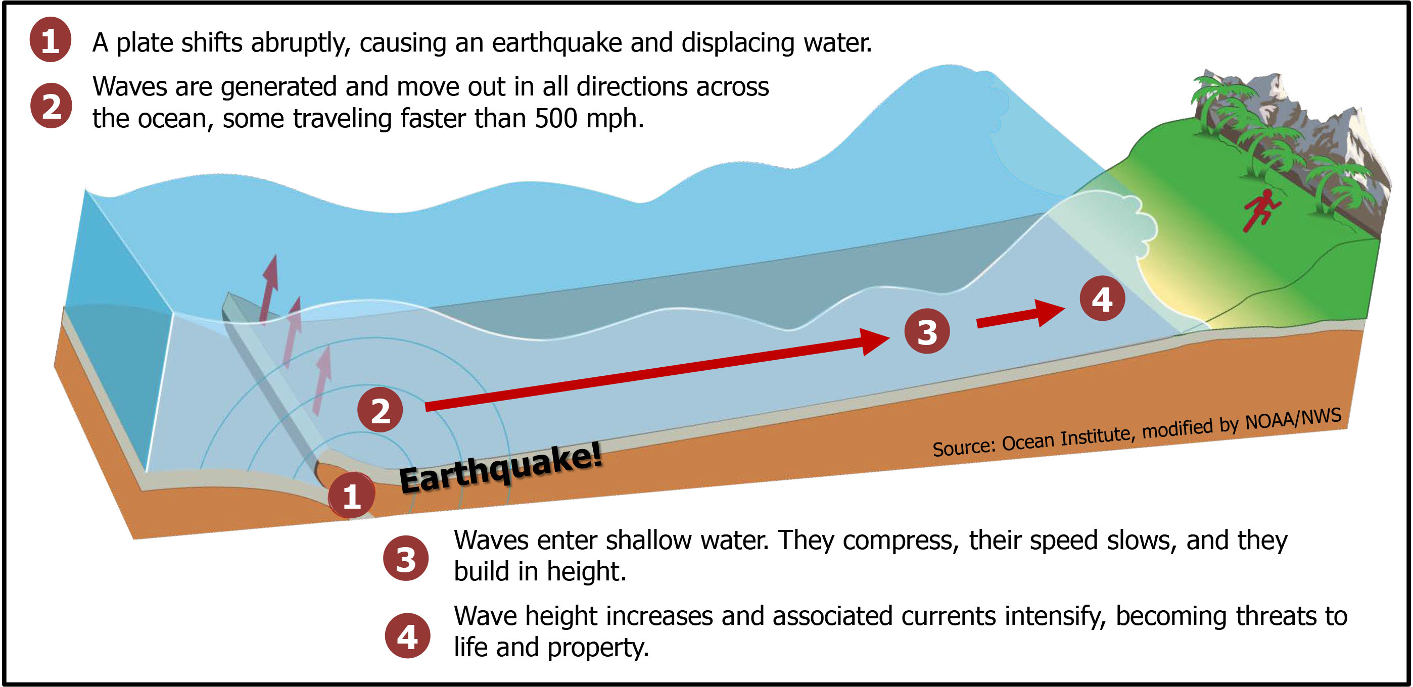
In theory, a very rare event could generate a tsunami (formerly called a "tidal wave"). As a tectonic plate slips underneath or alongside another tectonic plate, one plate rises up and displaces water in the ocean. An underwater landslide triggered by an earthquake could magnify the displacement of water. On March 11, 2011, a quake near Japan produced a major tsunami that reached 130' high on the nearby shoreline. About 18,000 people died, and the cores of three nuclear reactors at Fukushima melted after they lost their cooling systems.
In theory, an earthquake in the Atlantic Ocean could create a sudden increase in water level on Virginia's eastern coastline and briefly raise it in a series of surges (not just one wave) as much as 10-25 feet higher. The risk of Virginia being affected by a tsunami is considered very low, but the disastrous December 2004 tsunami in the Indian Ocean caused people to pay closer attention to the threat.
In 2006, Norfolk became the first East Coast city to earn recognition by the National Oceanic and Atmospheric Administration (NOAA) as "TsunamiReady/Storm Ready." According to the local paper, assistant director of Emergency Preparedness and Response was not worried about a tsunami, but:2
...decided to pursue the federal TsunamiReady certification, even though he admits the odds are better for him to hit the Mega Millions lottery than for a tsunami to strike Hampton Roads. "I went after it because of the potential there would be some federal funds available," he said. Then again, in his business, he said, you can't be too careful.
"Norfolk applying for the TsunamiReady program might sound a little farfetched," Talbot said, "but if something would happen, we have procedures in effect and know what to do."
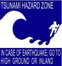
tsunami risk - especially low on the Virginia coast
Source: National Oceanic and Atmospheric Administration (NOAA), National Geophysical Data Center - Natural Hazards Viewer
Preparing for unexpected tsunamis would help prepare for storm surges associated with expected hurricanes. In addition, the risk to Norfolk is greater than zero. Tsunamis have struck the western edge of the Atlantic Ocean, north and south of Norfolk/Virginia Beach.
It is possible that the meteor impact 65 million years ago, which created the Chicxulub crater and led to the extinction of the dinosaurs, triggered landslides on the continental shelf and tsunamis along the Gulf Coast and even the Virginia shoreline.3
Such a worst-case scenario involving an impact and tsunami has occurred at least once in what is now Virginia. A bolide, a comet or asteroid, hit the Atlantic Ocean 35 million years ago. It instantly evaporated a coolumn of seawater and created a massive crater near what today is Cape Charles on the Eastern Shore. (At the time, there was no Eastern Shore or Chesapeake Bay. Those features were created later as sediments washed down the East Coast and the Susquehanna River valley.)
The impact created an initial tsunami when the bolide displaced Atlantic Ocean water and triggered a wave that raced across the Coastal Plain and Piedmont. As water rushed back into the impact hole, multiple surges of water radiated away from the site. The tsunamis caused massive devastation to forests and wildlife; everything living on the surface within perhaps 200 miles was toppled over or drowned.
The impact sent waves far inland. According to the US Geological Survey:4
It is likely that the tsunamis reached and possibly overran the Blue Ridge Mountains.
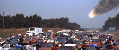
The makers of the Hollywood sci-fi movie Deep Impact created a climactic final scene where a meteor struck the Atlantic Ocean off Virginia Beach. Hollywood altered geographic reality to enhance the dramatic scene at the end of the movie, where people trapped in a traffic jam were swamped by waves as key characters raced up the mountain slopes.
That scene was filmed on the Route 234 bypass in Prince William County, which was then under construction. There are no such mountains near Virginia's coastline. In Virginia, the closest hill to the Atlantic Ocean is a former landfill in Virginia Beach known as Mount Trashmore.
Another clue that the "movie mountains" in Deep Impact were not in Virginia is that they were covered by ponderosa pines. That species grows only west of the Mississippi River, so the scene where characters raced away from a tsunami was not filmed anywhere in Virginia.
a Hollywood movie scene of a traffic jam, filmed in Prince William County, showed a meteorite about to create a tsunami at Virginia Beach
Source: The Rellim Zone, "Movie Review - Deep Impact (1998)"
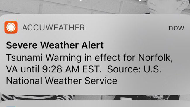
Some residents of Virginia Beach thought that a real tsunami was about to arrive in February, 2018. AccuWeather, a weather forecasting company, issued a tsunami alert for cities along the East Coast. A second alert two minutes later announced that it was only a test. The National Weather Service conducts monthly tests of the Tsunami Warning System, and somehow the test signal was misinterpreted as the real thing.5
Bolide impacts are very rare events, with no predictable pattern for re-occurrence. The Chicxulub event 65 million years ago and the Chesapeake Bay impact 35 million years ago created dramatic impacts, but the Tsunami Ready program anticipates a tsunami created by an earthquake and/or underwater landslide has a higher statistical probability.
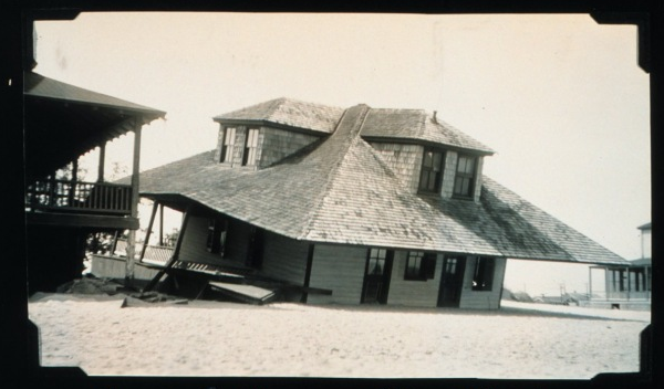
Port Royal in Jamaica was hit by tsunamis after a 1692 earthquake. The Palisadoes sandspit sank, killing one-third of the residents. That provides an indication of the potential worst-case impact to residents on Willoughby Spit in Norfolk.6
damage at Willoughby Spit after 1933 hurricane
Source: National Oceanic and Atmospheric Administration (NOAA) Photo Library
An 8.5-9.0 magnitude earthquake in Lisbon, Portugal in 1755 generated a tsunami all the way across the Atlantic Ocean in the Caribbean. Reports from the island of Martinique indicated that water rose as much as 30 feet high, in four separate cycles.7
To the north, Newfoundland was affected by a tsunami in 1929. It was noticed as far south as South Carolina, so Virginia was also affected.8
On June 13, 2013, a storm (derecho) off the coast of New Jersey or an underwater landslide triggered a minor tsunami that was clearly observed on the Atlantic Ocean shoreline. A breakwater that is normally 3-4 feet underwater was exposed, and three people were swept into the ocean from rocks that were 5-6 feet above sea level.
In Virginia, a tsunami with a minor rise in water level was recorded six hours later. The gauge at Chesapeake Bay Bridge-Tunnel recorded a 3-inch rise, and 12 minutes later the gauge at Kiptopeke recorded a maximum rise of 10 inches. That change was well within the normal 1-3 feet tidal range that occurs roughly every 12 hours, and caused no damage.9
In 2000, a scientific study of cracks at the edge of the coastal shelf suggested how a damaging tsunami could be generated near the Virginia coast, despite the small number of earthquakes in the region. Landslides occur along the continental slope, initiated by earthquakes and "mass wasting" of excessive accumulation of sediments on the continental slope.
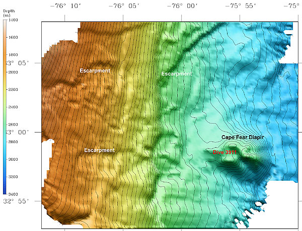
The Cape Fear Slide, on the Outer Continental Shelf off the North Carolina coast, is one of the largest underwater landslides documented on the eastern edge of North America. It was triggered when a layer of salt rose up under pressure from overlying sediments, forming a dome with steeper and steeper slopes until the sediments broke free. A comparable slide today could generate a wave over 6 feet high on the Outer Banks of North Carolina.
An underwater landslide off the Eastern Shore may have generated a tsunami in 1821. Flooding on Assateague Island occurred soon after a Category 4 hurricane passed. The speed of the event is inconsistent with a storm surge, but a contemporary report may have exaggerated that speed:10
...a monstrous wall of inky waters rushed with the speed of lightning toward the island. It struck Assateague, and in a moment half the land was a waste of seething foam and tossing pine trunks; the next instant it struck Chincoteague, and in an unbroken mass swept across the low south marsh flats, carrying away men and ponies like insects; rushing up the island, tearing its way through the stricken pine woods...
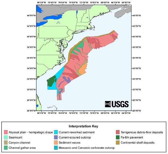
Sonar has documented numerous underwater landslides off the East Coast, along the edge of ravines that rivers carved into the shelf when water levels were lower. Massive slides include the Albemarle-Currituck Slide, Cape Lookout Slide and Cape Fear slide.
there is clear evidence of numerous underwater landslides ("terrigenous debris-flow deposits") on the Outer Continental Shelf along the East Coast
Source: US Geological Survey (USGS), U.S. EEZ Atlantic Continental Margin GLORIA
As sediments flow down the Continental Slope, they push water forward. Even if an underwater landslide flowed away from the East Coast, such an event could cause a surge on the Virginia shoreline.11
About 20,000 years ago, landslides flowed towards the East Coast from salt diapirs off the North Carolina coast at Cape Fear. Massive underwater landslides have occurred on an average of once every 1,000 years off the coast of Nova Scotia, including one after the 1929 Grand Banks earthquake which triggered a tsunami that killed 28 people in Newfoundland.12
landslides from Cape Fear diapirs have flowed towards the East Coast, increasing the potential impact from a surge of water
Source: National Oceanic and Atmospheric Administration (NOAA), Exploration of the Cape Fear Diapir
Research indicates that even a large 7.5 magnitude quake "must be located offshore and within 100 km of the continental slope to induce a catastrophic slope failure" to trigger a tsunami large enough to flood Virginia Beach, Norfolk, or the Eastern Shore. That assessment has reduced fears that earthquakes in the seismically-active Caribbean might pose a serious risk to Virginia.13
The Virginia shoreline is far from the closest zone in the Caribbean Sea where tectonic plates, sliding in a quick jerk, could generate a giant wave. Tectonic plates in the Caribbean caused the 2010 Haiti earthquake, and will move again. However, wave energy from that region would be deflected by Florida or directed into the open Atlantic Ocean, and would have minimal impact in Virginia.14
Another unlikely risk is that the Cumbre Vieja volcano in the Canary Islands could collapse. Landslides and earthquakes do cause tsunamis that affect shorelines far away. The 1964 Alaskan earthquake created a killer tsunami far away at Crescent City, California. An underwater quake near Indonesia in December, 2004 created a tsunami that killed people all the way across the Indian Ocean in Kenya.
After 10,000 more years, Cumbre Vieja could become unstable enough to collapse. In a worst case scenario, the entire flank would collapse in one event, rather than in a series of landslides as have occurred in the past, and threaten the East Coast of the United States.15
The hypothetical worst-case scenario could generate a 10-25 foot high tsunami on the Virginia coast on the other side of the Atlantic Ocean. If the flank of the volcano moved as a coherent block in a rapid mega-landslide, it might generate the sort of mega-tsunami that Hollywood shows in disaster movies that portray the destruction of New York City.
The hypothesis is unrealistic, though popular because of its potential dramatic impact.
Major landslides have occurred at the Cumbre Vieja volcano, but they occurred in phases rather than all at once. Each phase may have generated a local tsunami, but there is no evidence of a collapse that generated a mega-tsunami large enough to affect the East Coast of the United States.16
Catastrophically-high waves do occur. The largest recorded was in Alaska in 1958. A landslide triggered by an earthquake dropped a side of a mountain into a narrow fjord and triggered a wave 1,719 feet high. The collapse of the side of another mountain in 2025 created another wave that reached 1,580 feet high on the opposite shoreline. A cruise ship had been sightseeing at the mouth of the fjord just 12 hours earlier.
There are no such narrow mountain valleys along Virginia's flat Atlantic Ocean shoreline. Hollywood movies may suggest there is a possibility of a dramatic life-extinguishing tsunami, but planning for a wave of that height hitting Virginia is not a realistic scenario.17
A 2016 Discovery Channel program highlighted the rare possibility that a tsunami created by a landslide on the other side of the Atlantic Ocean could threaten the United States. The Tsunami Society recognized that many viewers might consider the risk to be significant rather than understand the very low probability, and responded with:18
While the active volcano of Cumbre Vieja on Las Palma is expected to erupt again, it will not send a large part of the island into the ocean, though small landslides may occur. The Discovery program does not bring out in the interviews that such volcanic collapses are extremely rare events, separated in geologic time by thousands or even millions of years.
No such event - a mega tsunami - has occurred in either the Atlantic or Pacific oceans in recorded history. NONE.
Canary Islands, far across the Atlantic Ocean from Virginia...
Source: National Oceanic and Atmospheric Administration (NOAA), National Geophysical Data Center - ETOPO1 1 Arc-Minute Global Relief Model
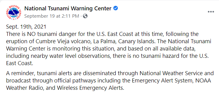
In 2021, a volcanic eruption in the Canary Islands led to fake social media claims that a tsunami was headed to the East Coast. Only about 5% of the tsunamis are generated by volcanoes, but a volcanic eruption near Tonga in the Pacific Ocean in 2022 triggered actual tsunami warnings. In California, pressure from the eruption more than 5,000 miles away caused water levels to rise as much as four feet.19
a volcanic eruption in the Canary Islands led to a fake tsunami alert in 2021
Source: National Oceanic and Atmospheric Administration (NOAA), National Tsunami Warning Center (September 19,2021)
The National Weather Service ranks the probability of a tsunami on different shorelines. The Alaska Arctic Coast has the lowest probability, ranking "Very Low." The "High to Very High" probability is assigned to the Pacific Coast of Alaska, the U.S. West Coast, and Hawaii. The Atlantic Coast is ranked as "Very Low to Low," because:20
There is no subduction zone along the U.S. Atlantic Coast, and earthquakes are not as large or as frequent as in other regions. Underwater landslides and meteotsunamis are the most likely source of tsunami waves in the region. More distant tsunami threats come from the Puerto Rico trench, the Canary Islands, and the Azores-Gibraltar fault zone.
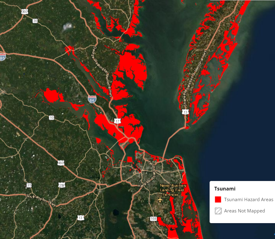
most waterfront property along the Chesapeake Bay is within a tsunami hazard area
Source: National Oceanic and Atmospheric Administration (NOAA), Coastal County Snapshots
Potentially, warming of methane hydrates (natural gas) now buried in ice crystals in coastal shelf sediments could "bubble up" if warm ocean currents shift location. The gas is frozen, for now.
If there was a change in water pressure, perhaps triggered by ocean warming, a strong hurricane, or small landslide, a burst of methane could be released. A series of giant gas bubbles could create a massive underwater landslide on the Continental Slope. That could displace enough Atlantic Ocean water to generate a tsunami that could reach the Eastern Shore, Norfolk, and other coastal areas.21
The potential of a tsunami generated by a volcano collapse in the Canary Islands, an underwater earthquake or landslide, or the release of a gas bubble catches the attention of those interested in rapid, catastrophic change. A collapsing edge of a glacier melting on Greenland has created massive surges of water sloshing high up the hillsides in narrow valleys.
However, the primary flooding threat to Hampton Roads is from a storm surge associated with a hurricane, and the risks of such flooding increase as sea level rises. Storm surges are a clear and present danger, while tsunamis caused by landslides or collapsing volcanoes are a much smaller risk. Disaster management specialists still plan for a tsunami because one could have a devastating impact on Tidewater Virginia, while they take advantage of Tsunami Ready funding to prepare for the greater risk of storm surges.
Perhaps the greatest risk to Virginia is a "meteotsunami," a weather-generated surge of water. Charges in air pressure from a storm front such as a derecho, or from severe thunderstorms, can trigger changes in water level that qualify as a tsunami. Though rare, meteotsunamis may be the cause of the 10% of the events identified in the last 4,000 years as having an unknown origin.
A 10-foot high wave has been triggered by a meteotsunami in Lake Michigan. Japan and places in the Mediterranean Sea have experienced wave action that was 15-20 high.
The largest identified metetsunami event in the Chesapeake Bay created a wave that was less than two feet high, in 2012. Had anyone observed it during the passage of a weather front, the change in the water level would have been obscured by other wave action.
Wave dynamics off the Atlantic Coast are counter-intuitive. Storms moving from west to east pushed water to the edge f the Continental Shelf. At the shelf break, where distance from ocean surface to the seafloor becomes much deeper. water moving east speeds up. That initiates a reflection wave which moves back west to the shoreline, and people in the water and on the beach experience a rapid change in water level without any warning. In 2013, swimmers in in Barnegat Inlet, New Jersey, were pulled over the breakwater into the ocean and then pushed back into the inlet and people standing on the south jetty were knocked into the water.
The bathymetry of the Atlantic Ocean along the Virginia coastline may not be favorable for amplification or for resonance to occur, but meteotsunamis have caused waves over 10' high to strike the coast of Florida in 1992 and Maine in 2008.22
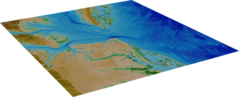
bathymetric-topographic digital elevation model (DEM) of Virginia Beach area, used to calculate tsunami inundation risk
Source: National Geophysical Data Center - National Oceanic and Atmospheric Administration (NOAA), Virginia Beach, VA 1/3 arc-second MHW DEM
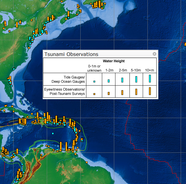
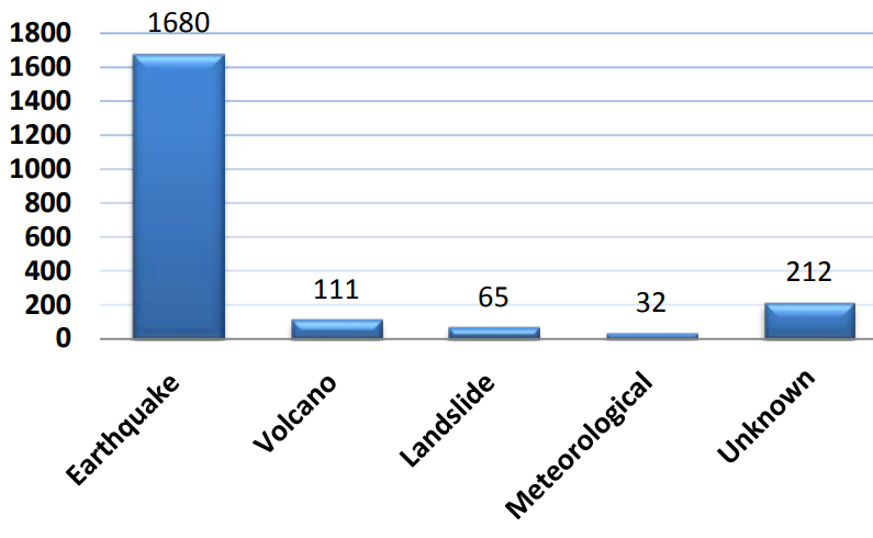
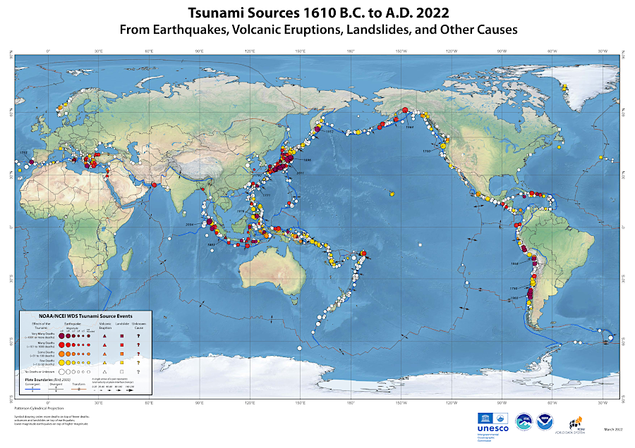
most tsunamis are triggered by earthquakes and volcanic eruptions at the edge of tectonic plates
Source: International Tsunami Information Center, Global and Regional Hazard Maps