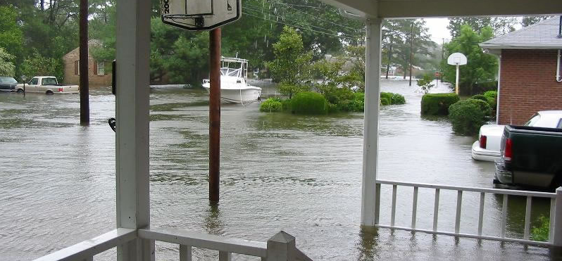
flooding during Hurricane Isabel in 2003
Source: National Weather Service, Hurricane Isabel Photo Gallery
flooding during Hurricane Isabel in 2003
Source: National Weather Service, Hurricane Isabel Photo Gallery
Norfolk is only a few feet above sea level. The same is true about the rest of the urbanized Hampton Roads area, including Virginia Beach, Portsmouth, Chesapeake, Suffolk, Hampton, Poquoson, Newport News, and Gloucester.
The reservation of the Pamunkey tribe, where Native Americans have lived for at least the last 3,000 years since the Chesapeake Bay reached its current size, is at risk. In 2025, the National Trust for Historic Preservation listed the reservation as one of America's 11 Most Endangered Historic Places. Though the tribe sought to mitigate impacts by defining a Community Disaster Resilience Zone and stabilizing part of the Pamunkey River shoreline, the reservation was expected to be underwater by the year 2100.
If current trends continue, the question is not "will Norfolk (and the rest of Hampton Roads) drown?" but "when will Norfolk, Tangier Island, Chincoteague, and other locations near sea level drown - and what should be the response to this threat in coastal areas?"
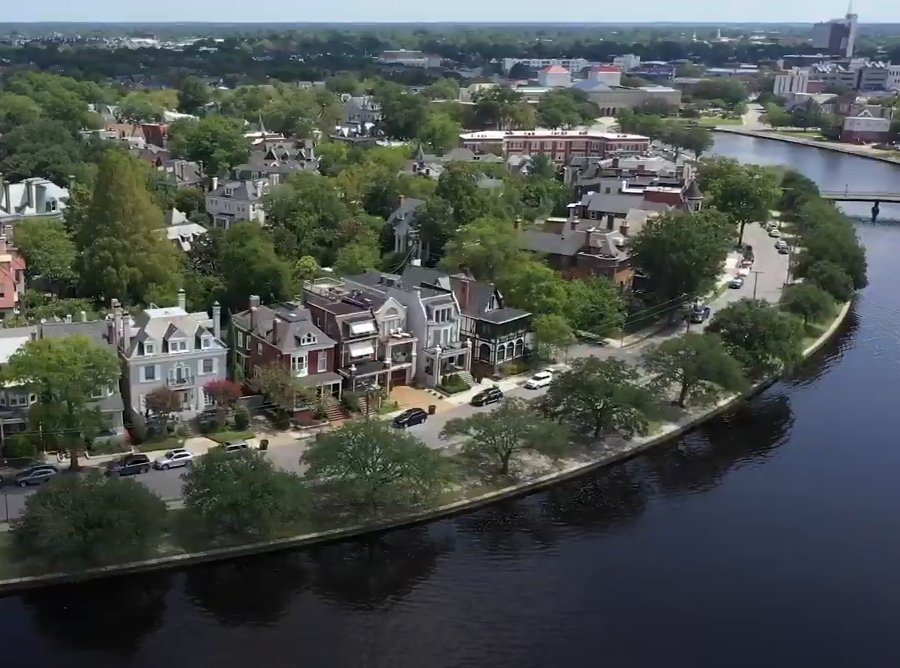
Norfolk neighborhoods near the Elizabeth River are particularly threatened by sea level rise
Source: All In For Norfolk Casino, Norfolk Resort & Casino
It is unrealistic to expect owners of private property along the shoreline to passively accept that valuable land, houses, and businesses will wash away in the next century and that no action should be taken to protect current infrastructure. When we buy bananas at the store, we don't expect them to last forever - but the American image of land is that it should last forever, and government agencies should respond when natural processes threaten the value of real estate.
However, taxpayers living away from the coastal zone may object to subsidizing insurance and disaster relief costs for coastal communities, especially expensive waterfront homes built in areas of known risk. If Federal and state funding will be provided, should it finance seawalls, groins, and other shoreline hardening techniques to mitigate impacts in the next 25-50 years, or should government investments focus now on moving existing structures away from the high-risk areas over the next 100 years?
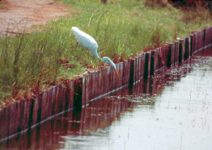
egret trying to feed from bulkhead (hardened shoreline)
Source: US Fish and Wildlife Service, Back Bay National Wildlife Refuge Comprehensive Conservation Plan
Should local cities/counties that issue building permits require that all new structures near the shoreline must be built even higher that the current National Flood Insurance Program maps mandate, just in case predictions of a speedup in sea level rise (compared to historical rates) comes true? How should government agencies deal with old infrastructure, such as sewers, that are at risk from flooding as sea levels continue to rise?
Undeveloped places, such as the Chincoteague National Wildlife Refuge and False Cape State Park, will also be affected. Should places with just plants and animals be sacrificed as the waters rise, so funding can be directed towards urbanized site and shoreline houses? Or should we consciously decide to retreat from the shoreline, removing buildings and converting now-developed parcels into parkland as part of a "managed retreat" strategy over the next 50 years?
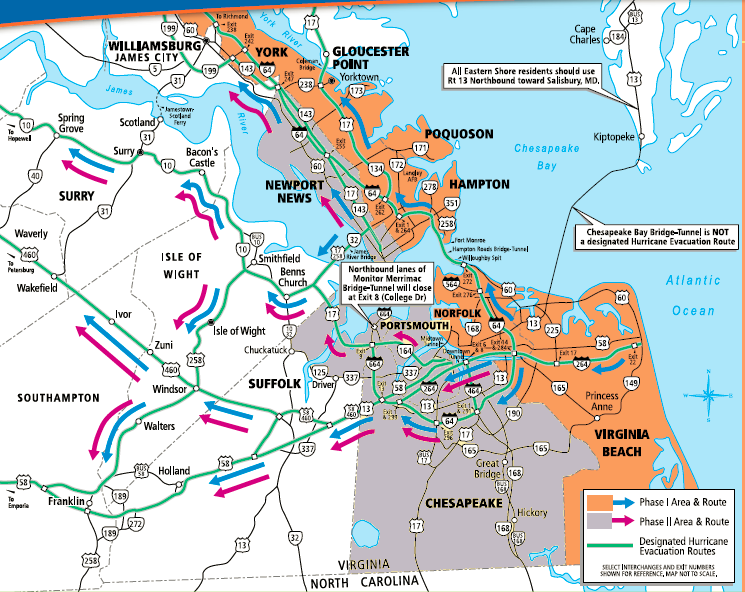
Phase 1 and Phase 2 evacuation routes for people in vehicles to flee Hampton Roads
Source: Virginia Hurricane Guide
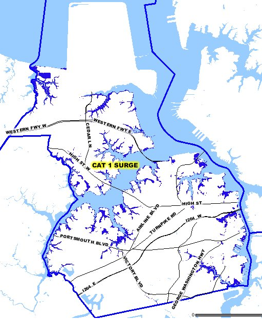
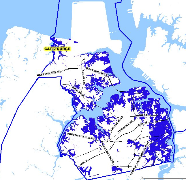
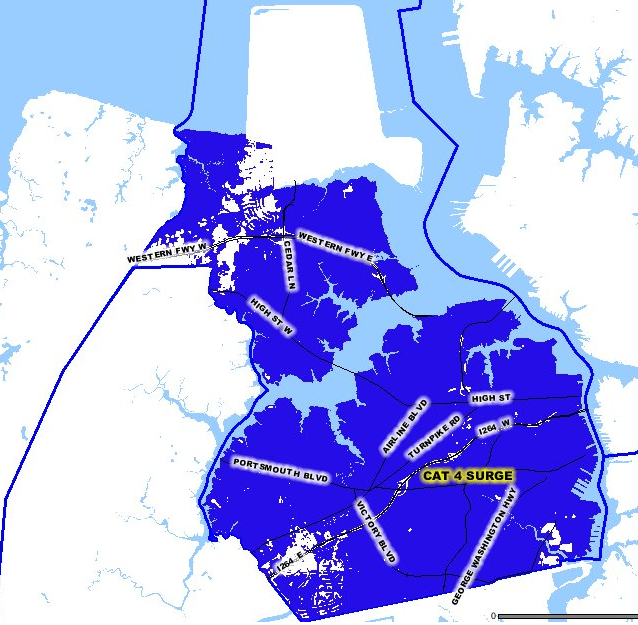
The Hurricane Flooding and Tidal Surge maps from the Hampton Roads Emergency Management Committee show that a storm surge from a Category 3 hurricane would affect much of the Hampton Roads area. Flood waters could inundate large portions of the developed shoreline, if the moon and tides push tides to their maximum height when a storm arrives.1
Half the residents in Hampton Roads, especially those in Virginia Beach/Norfolk, are supposed to evacuate on I-64 through the Hampton Roads Bridge-Tunnel. Special gates have been installed on access ramps so every lane of the interstate could be used to move people east past Williamsburg. However, the Virginia Department of Transportation (VDOT) will close bridges and tunnels connecting South Hampton Roads to the Peninsula once sustained winds reach 45mph.2
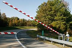
hurricane gates on Interstate 64
Source: Virginia Department of Transportation
The storm surge from a Category 1 hurricane is projected to cover I-64 on Willoughby Spit, blocking evacuation by car through the Hampton Roads Bridge-Tunnel. Hampton Roads residents will need to be convinced to leave Norfolk/Virginia Beach long before any major storm arrives, if the plans for moving people out of the danger zone are going to succeed.
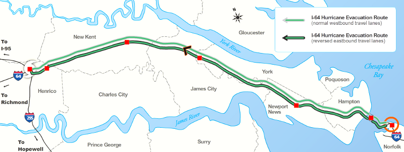
I-64 lane reversal between Norfolk and I-295 beltway, west of Williamsburg
Source: Virginia Department of Emergency Management Virginia Hurricane Evacuation Guide
Hurricanes are fueled by warm water, so a Category 5 storm could impact Florida or the Gulf Coast. Emergency management professionals do not consider seriously the impact of Category 5 storms hitting Norfolk/Virginia Beach; the Commonwealth of Virginia Storm Surge Inundation Maps only consider Category 1-4 hurricanes.
Category 5 hurricanes at Chesapeake Bay are unexpected because of the latitude and the pattern of ocean currents. Hurricanes lose energy as they move north and encounter colder water. Even with the Gulf Stream, the ocean at 36 degrees 30 minutes of latitude (the Virginia-North Carolina border) is too cold for a hurricane to reach Virginia with enough energy to qualify as Category 5. However, climate change could lead to warmer water moving north, which could lead to more-intense hurricanes striking Virginia.
Some Category 5 storms hit the Gulf Coast and then move inland to Virginia, such as Hurricane Camille in 1969. The winds drop to tropical storm status as the weather system travels over land from the Gulf of Mexico to Virginia, but the storms can still drop massive amounts of rain and cause death and destruction in the Blue Ridge.
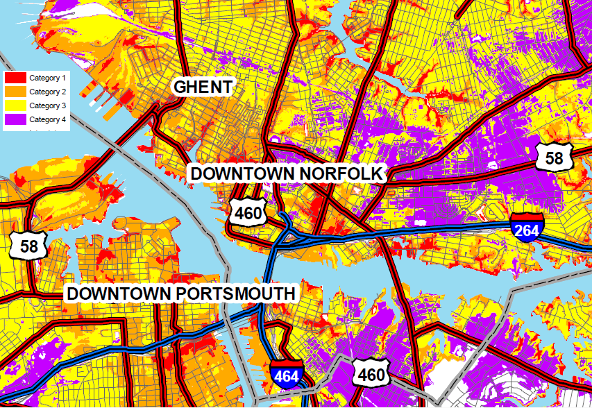
areas in Norfolk/Portsmouth expect to be flooded by storm surge from Category 1-Category 4 hurricanes
Source: Virginia Department of Emergency Management, Commonwealth of Virginia Storm Surge Inundation Maps
When a hurricane arrives, local officials can issue mandatory evacuation orders. For example, the City of Virginia Beach declared a Local Emergency when Hurricane Irene came ashore at Cape Hatteras, N.C. in August 2011. That storm was Category 1, after weakening just before landfall, but still caused nearly $60 million in damage in Virginia. The Federal government declared that 48 Virginia jurisdictions qualified for Public Assistance, which authorizes Federal funding for emergency response and repair/replacement/restoration of publicly-owned facilities and the facilities of certain non-profits.3
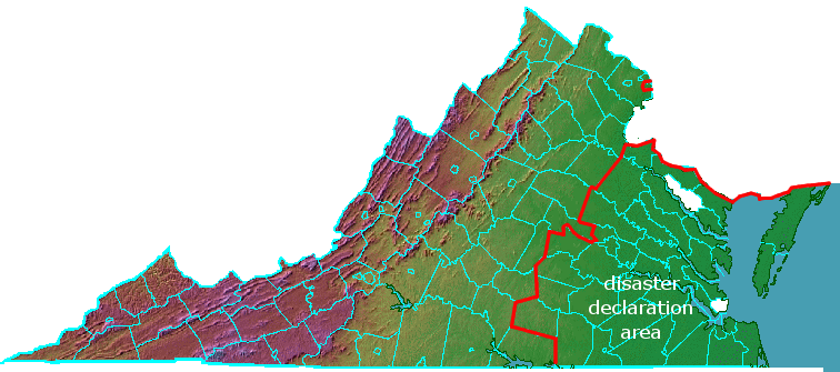
jurisdictions authorized for "Public Assistance" after Hurricane Irene by Federal disaster declaration FEMA-DR-4024, Virginia
(including Alexandria, excluding Gloucester and Richmond counties)
Source: Federal Emergency Management Administration, Virginia Hurricane Irene
The National Flood Insurance Program, managed by the Federal Emergency Management Administration (FEMA), provides coverage for damage to individual properties caused by floods. Private insurers will issue policies that deal with the risks from fire, wind, or visitors tripping on the front steps, but the premiums and deductibles reflect the different risks in different locations. House insurance premiums for Hampton Roads homeowners are roughly twice as high, compared to premiums for houses located in Alexandria and Roanoke.4
In addition to purchasing homeowners insurance, financial institutions that issue mortgages require a high percentage of Hampton Roads homeowners to purchase separate flood insurance policies. Standard homeowners insurance policies cover damage caused by a water pipe break within the house, but do not pay for damage caused by external floods. Flood Insurance Rate Maps produced by FEMA define a Special Flood Hazard Area, the area that has a 1% or greater annual chance of flooding (i.e., 100-year flood plain).
The cost of a National Flood Insurance Program policy for an individual property is tied to the risk of flooding at that specific location, and the elevation of the structure. Houses receive an Elevation Certificate, determining its height above/below the Base Flood Elevation with a 1% or greater annual chance of flooding.
For years, flood insurance rates were subsidized for 20% of the policies and did not reflect actual risk, or future risk from sea level rise. A 1991 FEMA report on the predicted impacts of sea level rise noted that nearly 20% more land would be at risk by a 1-foot rise in sea level, and nearly 40% more by a 3-foot rise:5
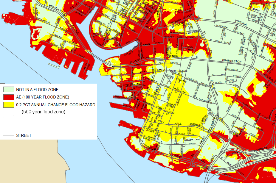
FEMA's interpretation of flood risk to downtown Norfolk and Ghent neighborhood
Source: City of Norfolk Map Gallery, Flood Insurance Rate Map
Insurance rates were too low to pay for claims (especially after the hurricanes in 2005, including Katrina), and Congress had to appropriate supplemental funding to bail out the insurance program. Subsidized insurance reduced the motivation of property owners to move out of high-risk flood zones. In addition, disaster recovery after tropical storms, hurricanes, and other events (such as Superstorm Sandy in 2012) is also funded largely by the Federal government.
Low-cost Federal flood insurance and the expectation of "free" Federal funding after a disaster reduced the pressure on homeowners to minimize risk. State/local government officials could encourage development in high-risk areas, since much of future disaster recovery costs would be funded by the Federal government.
In 2012, the Biggert Waters Flood Insurance Reform Act finally modified flood insurance rates to reflect full risk, phasing out most subsidies. FEMA ended the old pattern of maintaining low, "grandfathered" rates when Flood Insurance Rate Maps were updated to reflect higher risks. Starting in 2012, FEMA began to apply new rates that reflected actual risk after adoption of a new Flood Insurance Rate Map, with the higher rates gradually phased in.6
Cities in Hampton Roads could reduce long-term flooding costs by replanning/rezoning areas at risk to lower the number of structures that might end up in a future flood zone. In existing flood zones, cities could initiate a "retreat" strategy by acquiring existing structures that might flood and removing them. Over the next 50 years, now-developed land could become open space, ballfields and waterfront parks. The retreat option, reducing density of development in high-risk areas, would be expensive and reduce future property tax revenues. A retreat strategy requires either a long-term perspective, or a stimulus of some sort to alter current patterns of development.
repetitive loss areas in City of Hampton, where two or more claim payments of more than $1,000 have been paid within a 10-year period since 1978
Source: Peninsula Multi-Jurisdictional Natural Hazards Mitigation Plan - City of Hampton, Virginia, Repetitive Flood Loss Analysis (Appendix L)
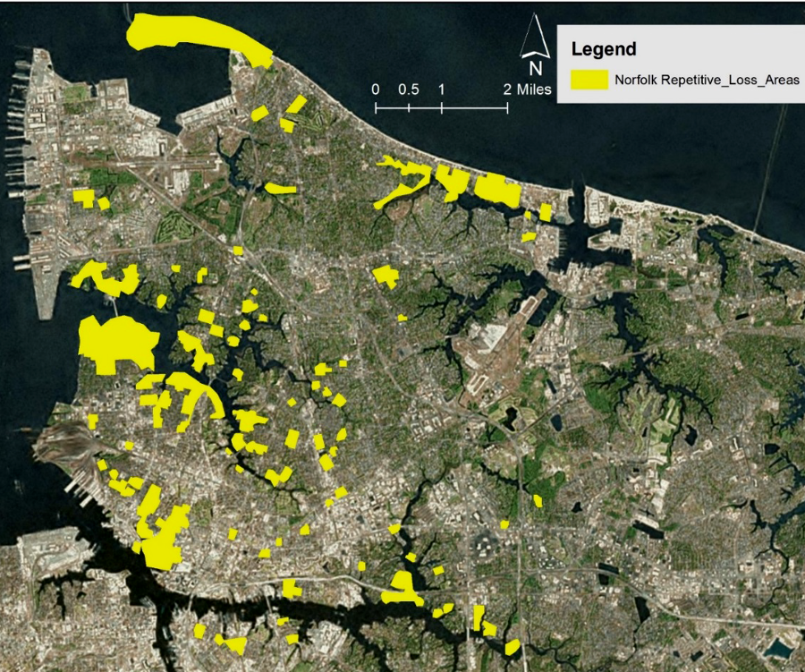
repetitive loss areas in Norfolk
Source: US Army Corps of Engineers, Draft Integrated City of Norfolk Coastal Storm Risk Management Feasibility Study / Environmental Impact Statement (Figure 10-9)
In 2012, an international insurance executive spoke at a forum on how climate change affects flooding risk, as part of the Old Dominion University Climate Change and Sea Level Rise Initiative. After a tour of Norfolk, she questioned why local governments are increasing risk by ignoring predictions of higher floodzones, approving new development in areas that will be affected if sea level rises:7
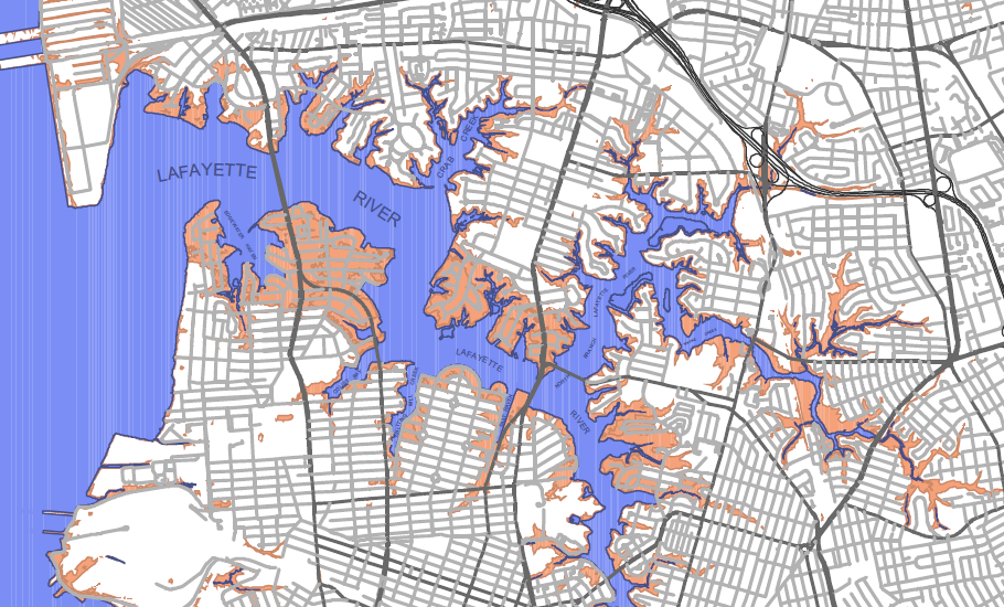
low-lying areas adjacent to Lafayette River, and expected to flood from storm surge of a Category 1 hurricane
Source: City of Norfolk, Category 1 Hurricane Storm Surge map
The State Corporation Commission, which regulates insurance in Virginia, must ensure insurance companies will be able to pay off all claims if a catastrophe does occur. Insurance companies focus on selected areas, establishing a network of agents and concentrating advertising in particular markets. However, if a "singularity" (such as a hurricane) occurs, then a company could be overwhelmed by the number of claims.
In 2007, Allstate announced it would maintain policies of existing customers in 19 Virginia counties, but would write no new policies in order to minimize the risk associated with hurricane damage. By 2013, Allstate had reentered the market, but with greater selectivity in choosing what sites to insure.8
It is in the interest of the State of Virginia to have insurance companies hedge their bets, and have only so many policies in one geographic area. To avoid the risk that an insurance company will go bankrupt rather than pay all potential claims, insurers who write many policies in one area will obtain re-insurance, basically buying coverage from other companies. That technique reduces profits, but spreads the risk. While hurricanes may be a low-probability of risk in Hampton Roads, they are not a zero-probability risks.

area predicted to be flooded in Portsmouth, by storm surge from Category 1-4 hurricanes
Source: City of Portsmouth Land Information System
(click on images for larger versions)
There are three significant threats to Hampton Roads that the insurance companies and banks (as well as government agencies) have to consider: storm surges from hurricanes, sea level rise, and tsunamis.
Massive rainfall from a storm can overwhelm the stormwater management systems in urbanized areas, as Hurricane Floyd demonstrated in 1999 when it swamped the city of Franklin and tropical storm Gaston did to Richmond's Shockoe Valley in 2004. In 2003, winds from Hurricane Isabel wrecked utility systems throughout the Coastal Plain of Virginia, leaving some people without electricity for two weeks. In 2011, Hurricane Irene blasted Hampton Roads, Richmond, and Northern Virginia east of I-95.
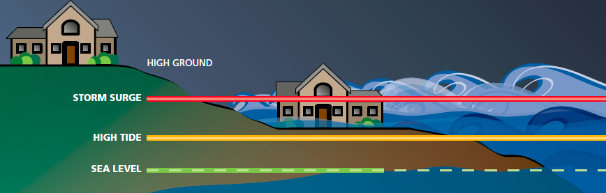
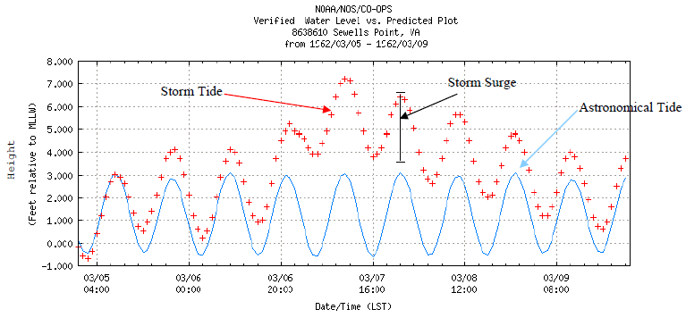
storm surge can be as much as 15 feet higher than high tide
Source: Virginia Department of Emergency Management, Virginia Hurricane Evacuation Guide
If a hurricane brings a storm surge of 6-8 feet into the region, much of Virginia Beach and Norfolk will be underwater due to the storm surge, the rise in sea level associated with the lower barometric pressure in the eye of the hurricane. Tidewater officials track hurricanes as closely as the officials in Florida or North Carolina, where most hurricanes come ashore on the East Coast, but no hurricane came ashore directly in Virginia in the 1900's.9
But inevitably, one is headed into the Chesapeake Bay. To prepare for evacuation, the state has designated hurricane evacuation routes for getting people out of the Hampton Roads area. The evacuation plan requires reversing eastbound I-64 to double the number of escape lanes headed west; there are gates on all interchanges between the high ground east of Williamsburg (I-295) and Hampton.
The Virginia Institute of Marine Science (VIMS) has even considered building a 24-mile long barrier at the mouth of the Chesapeake Bay, parallel to the bridge-tunnel, to block hurricane-caused storm surges. First step is to create computer models to assess potential designs and environmental impacts. The academic exercise requires making no decisions; the tough choices regarding costs vs. benefits (and how to ensure US Navy warships would never be trapped inside Hampton Roads) come later.10
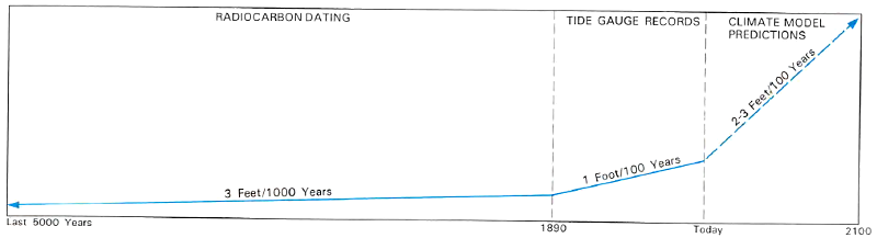
Sea level rise poses the greatest, long-term threat to Norfolk.
At various times, the Atlantic Ocean has been higher and Norfolk has been underwater; that is why there are whale fossils from the Miocene Period are found in sand/gravel deposits on the Coastal Plain. Since the end of the last ice age, the shoreline of Virginia has moved westward as the Atlantic Ocean has expanded and covered the continental shelf. The Native Americans who first settled Virginia camped on a different Atlantic Ocean coastline during their hunting and gathering expeditions. Their first campsites are probably 30-50 miles offshore now, under 300-400 feet of saltwater and recent sediments.
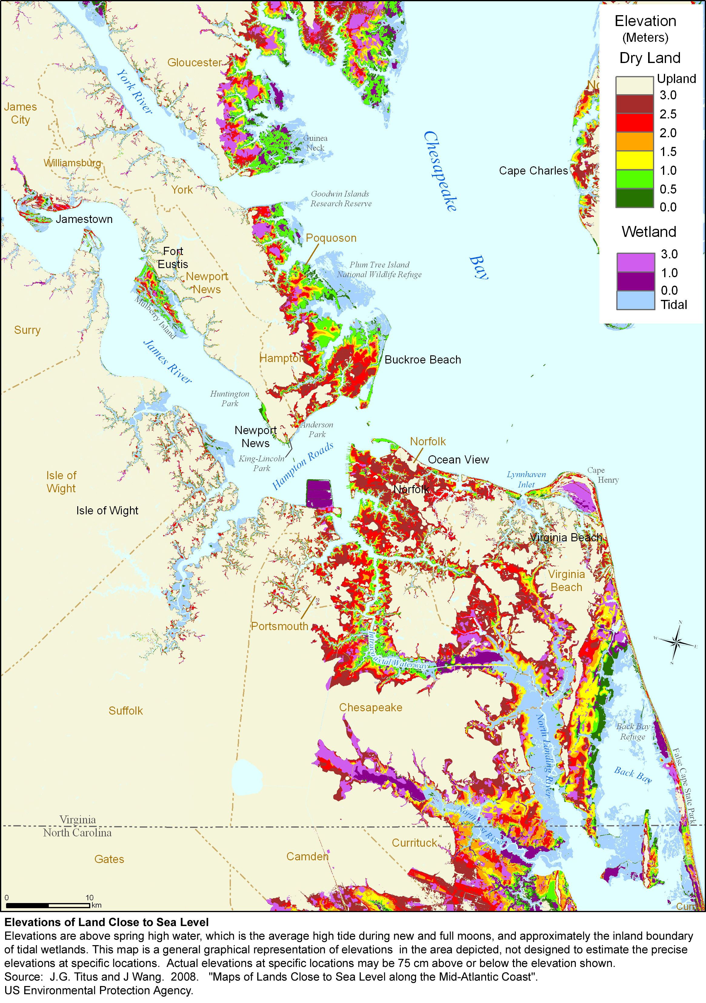
sea level rise predictions
Source: US Fish and Wildlife Service, Vanishing Lands - Sea Level, Society, and Chesapeake Bay (Figure 10)
Continued global warming could melt remaining ice on Antarctica and Greenland, adding more water to the oceans. A warmer atmosphere will warm up the water in the oceans, causing them to expand. The Intergovernmental Panel on Climate Change (IPCC) projects an absolute sea level rise of 1-3 feet in the next 100 years.
In 2018, the Virginia Institute of Marine Science (VIMS) calculated that sea level had risen six inches at the Sewells Point gauge between 1992-2018, and estimated sea level would rise another 12 inches there between 2018-2050. The change in sea level was due in part because land at Norfolk was sinking. Eastern Virginia had been lifted up when an ice sheet pressed down on the earth's crust in Pennsylvania. The retreat of the ice sheet starting 18,000 years ago allowed the land beneath Pennsylvania to rebound upwards, and for the Atlantic Ocean coastline in Virginia to drop back down.
Using synthetic aperture radar data, Virginia Tech researchers concluded in 2023:11
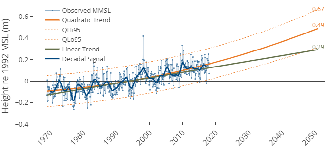
sea level is predicted to rise over 18 inches at Sewell's Point between 1992-2050
Source: Virginia Institute of Marine Science (VIMS), Norfolk Sea Level Report Card
There may be a "hotspot" for unusually rapid sea level rise in Virginia and further north if warmer, fresher ocean water alters the Gulf Stream and the North Atlantic Current, which currently depress sea level along the shoreline north of Cape Hatteras.12
The worst case scenario: if the West Antarctic Ice Sheet melts, sea level could rise 10-20 feet.13
The Town of Tangier, on a small island in the Chesapeake Bay, may be the first incorporated Virginia jurisdiction to disappear because of sea level rise. Several barrier island communities have been abandoned in the past, including Wash Woods in what is today's False Cape State Park. Residents of Hog Island, on the Atlantic Ocean side of the Eastern Shore, moved to Willis Wharf in Northampton County after a hurricane in 1933 flooded the island. Today, the island is a nature preserve, part of the Virginia Coast Reserve owned by The Nature Conservancy.14
Ever since the first Paleo-Indians arrived in Virginia, rising sea levels have been forcing humans to move their communities back from the edge of the Atlantic Ocean. However, the shifting shorelines that spurred abandonment of Hog Island may be triggered by normal barrier island sand migration, rather than increasing sea levels. An archaeologist working on the Eastern Shore has commented:15
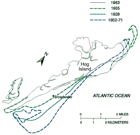
changing shorelines of Hog Island
Source: US Geological Survey Circular 1075, Coasts in Crisis
The City of Poquoson is another Virginia jurisdiction that might have to be abandoned, if sea level does rise three feet in the next 100 years. Poquoson's Multi-Hazard Mitigation Plan, when updated in 2009, acknowledged the risk.
According to the plan, "the majority of the City is less than seven feet NGVD" (National Geodetic Vertical Datum). In 2008, Poquoson made the risk of sea level rise a "critical hazard requiring mitigation." The slow, incremental rise is not the concern - the fear is that, because of the gradual sea level rise, a future storm will create a surge of high water that could cause great damage in just one day:16
storm surge, greatest cause of flooding during 1962 storm, could be one foot higher in 2030
Source: City of Poquoson Multi-Hazard Mitigation Plan
In addition to sea level rising, the land in the lower Chesapeake Bay is subsiding. The drop in the level of the land is caused by one or more of the following reasons:
If the land subsidence trends continue, Hampton Roads will experience 0.4-3.3 feet of land subsidence over the next century. The projections of sea level rise are regularly revised based upon new data and computer models. In 2022, the National Oceanic and Atmospheric Administration (NOAA) estimated that sea level would rise 15-18 inches by 2050 in Southeastern Virginia, in part due to the relatively rapid land subsidence there. At Sewells Point in Norfolk, sea level had already risen by 17 inches since 1927 while the global rate was just 7-8 inches. By 2021, land subsidence should increase relative sea level by another foot.17
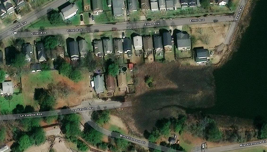
rising water levels threaten houses at the end of La Valette Avenue in Norfolk
Source: ESRI, ArcGIS Online
As described in "The State of the Region: Hampton Roads 2009" report:18
if sea level/land subsidence changes 3.7 feet, all the area in green will be flooded... and other land will be at risk from storm surges
Source: Greenhouse Effect and Sea Level Rise: America Starts to Prepare: Sea Level Rise Maps for Virginia
A third factor increasing flooding in Hampton Roads is an increase in annual rainfall. A study in 2016 concluded that at Norfolk International Airport:19
How will the tourism and real estate industries in coastal areas of Virginia be affected? One option is to harden the shoreline with seawalls or levees, building a protective ring around developed areas in the same way New Orleans is protected. That is the response being taken by the US Government at Wallops Island, to protect National Aeronautics and Space Administration's facilities. In 2012 the Federal government built a 14-foot high seawall, and widened the beach 82 feet to reduce the energy of ocean waves before they strike the hard barrier.20
After Hurricane Sandy in 2012, the US Army Corps of Engineers revised the rules prohibiting sand replenishment projects on beaches with hard barriers and approved a project to widen the beach at Ocean View. Sand dredged from the Thimble Shoal shipping channel will widen the beach by 60 feet for a seven-mile stretch, even though Norfolk had previously built 36 rock breakwaters. The sand will wash away, so the Corps committed to replenish that stretch of beach every nine years until 2056.21
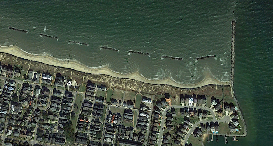
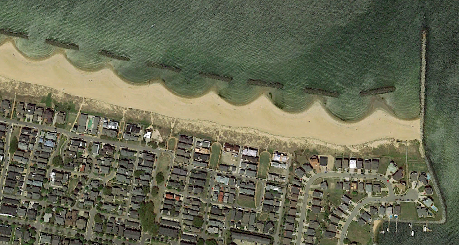
Ocean View beach, west of Little Creek inlet, in November 2015 and May, 2010
Source: Google Earth (historical imagery)
A sea wall to protect just key portions of Norfolk would be feasible but very expensive. A sea wall for Virginia Beach would be less suitable, since the city's tourist business is based on access to a sandy beach. A levee or barrier on the current dune line might limit future storm damage to structures along Atlantic Avenue, but hardening the shoreline would block the beach from migrating naturally and eventually eliminate the wide beach as sea levels rise.
As an economist and former president of Old Dominion University described it:22
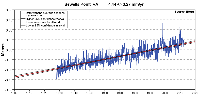
sea level rise at Sewells Point based on data between 1927 to 2006: a trend of 4.44 millimeters/year, equivalent to 1.46 feet in 100 years
Source: National Oceanic and Atmospheric Administration (NOAA) "Sea Levels Online," Mean Sea Level Trend, station 8638610 at Sewells Point, Virginia
The Virginia Beach Flood Protection Program was titled the "Ripple Effect." It relied upon different techniques at different locations within the city.
Beach replenishment is being used to protect the resort area along the Atlantic Ocean at Virginia Beach, though it may be only a short-term solution. Within 100 years, assuming sea level keeps rising as predicted, the current location of the sandy beach will be completely underwater and the shoreline will have moved west.
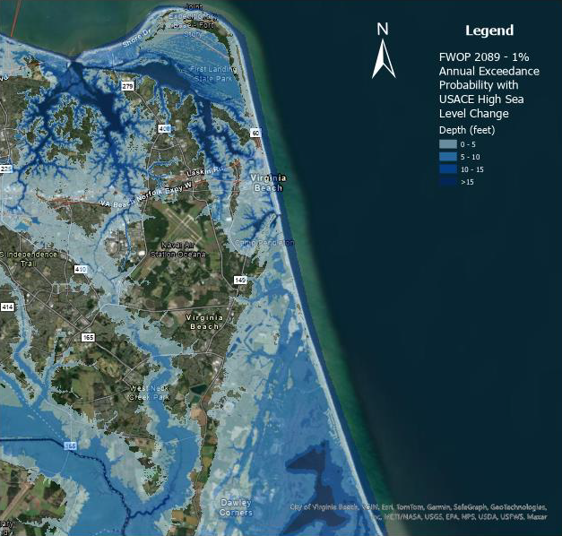
much of Virginia Beach will be in the 100-year floodplain by 2089
Source: City of Virginia Beach, Virginia Beach Coastal Storm Risk Management Feasibility Study
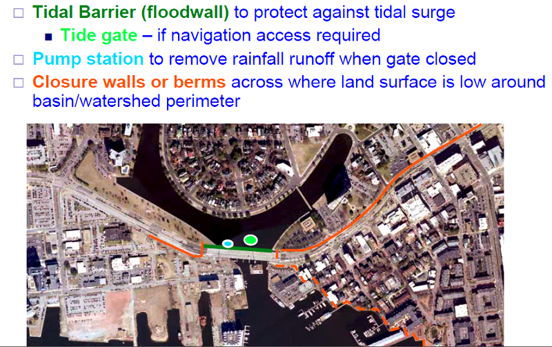
Virginia Beach built the Windsor Woods Tide Gate to manage flooding in Thalia Creek, a tributary at the headwaters of the Lynnhaven River next to Mount Trashmore that was flooded during Hurricane Mathew in 2016. At low tide, the four gates close. That blocks the rising tide from entering the creek, allowing the "empty" stream channel to store more runoff. Pumps move water trapped in Thalia Creek behind the tide gate to the other side, adding more capacity and reducing flooding upstream in the neighborhoods of Windsor Woods, The Lakes, and Princess Ann Plaza.
The tide gate passed its first test during Hurricane Erin in August, 2025. As planned, the water level in Lake Windsor was lowered before the storm arrived by pumping into Thalia Creek. Rain was captured in the lake, and flooding of houses in the neighborhood was avoided.
Source: City of Virginia Beach, How It Works - Windsor Woods Tide Gate
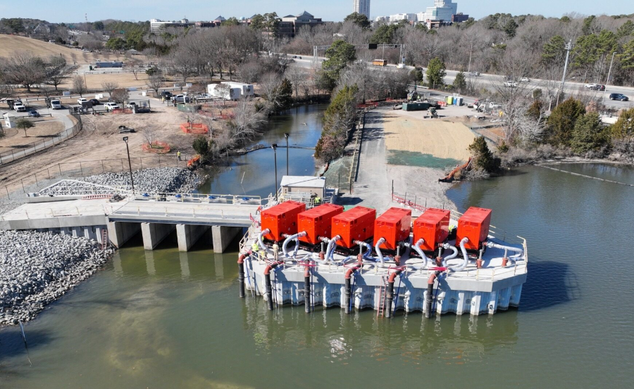
the Windsor Woods Tide Gate next to Mount Trashmore controls flooding in Thalia Creek
Source: City of Virginia Beach, The Ripple Effect: Windsor Woods Tide Gates Put to the Test
The city of Virginia Beach adopted a Sea Level Rise Adaptation Strategy in 2020. In 2026, the Virginia Beach Coastal Storm Risk Management Feasibility Study identified the next priority tide gate location to be at Lesner Bridge to Lynnhaven Inlet. Larger tide gates to block storm surges (but not sea level rise) are being considered for installation at Rudee Inlet and the Eastern Branch of the Elizabeth River.
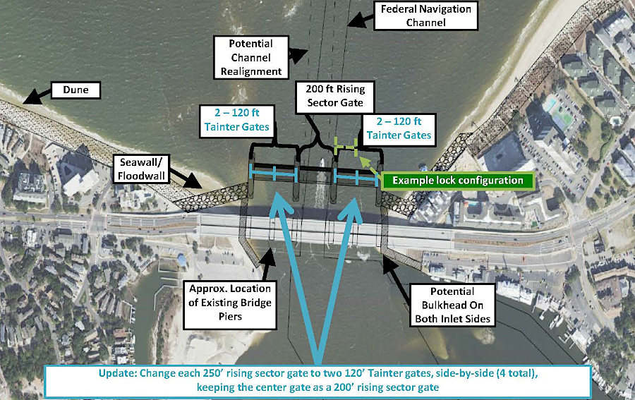
Virginia Beach has prioritized planning to install tide gates to block a storm surge at Lynhaven Inlet
Source: City of Virginia Beach, Virginia Beach Coastal Storm Risk Management Feasibility Study
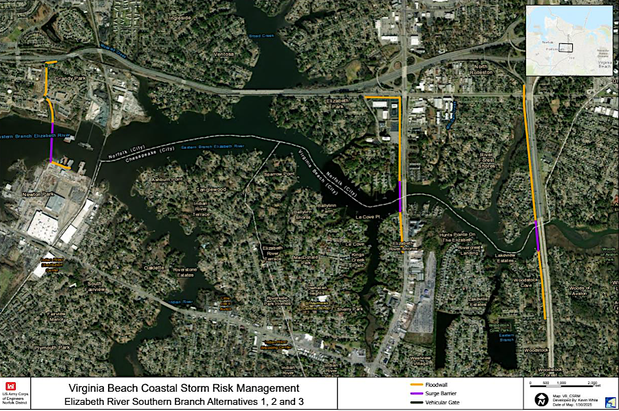
tide gates could be installed at one of three locations on the Southern Branch of the Elizabeth River
Source: City of Virginia Beach, Virginia Beach Coastal Storm Risk Management Feasibility Study
In addition to beach replenishment and flood control infrastructure, the City of Virginia Beach also has the option of "strategic retreat." It could sacrificing developed areas, removing houses, roads, etc. and dedicate the space to storing floodwater. Even the hotels along Atlantic Avenue could be removed to allow the beach to migrate naturally. As sea levels keep rising over the next 200 years, the city could eventually remove the next block of developed property along Pacific Avenue as the new shoreline migrates westward.
Strategic retreat avoids the cost of rebuilding and maintaining structures despite repeated flooding events. On the undeveloped Atlantic Coast shoreline of Virginia's Eastern Shore, allowing the water to rise would have minimal impact on property values; there are few structures near the water's edge. At Virginia Beach, however, the cost to remove military facilities at Joint Expeditionary Base Fort Story and the housing/commercial development along Atlantic Avenue would be extraordinarily high.
All the development on Tangier Island in the middle of the Chesapeake Bay is at high risk:23
Within Virginia, the jurisdictions with the greatest number of acres at risk from sea level rise are Accomack County, City of Virginia Beach, and Northampton County - not surprising, considering their location and size. Other jurisdictions in Hampton Roads, and counties on the Peninsula/Middle Peninsula/Northern Neck, may be equally exposed to flooding, but are smaller in area.
Within Virginia, there are 140 square miles of dry land within 1 meter of sea level, over half of which has already been developed. In Portsmouth, 80-90% of the city would be underwater if a Category 3 hurricane struck. There are also 55 square miles of non-tidal wetlands and 625 square miles of tidal wetlands, which provide environmental values but are not likely to be protected from sea level rise.
Not all infrastructure in Hampton Roads is at sea level. The Norfolk International Airport (ORF) is at 26.7 feet in elevation. Ronald Reagan Washington National Airport is only 14.1 feet above sea level, so the risks of flooding runways in Arlington County are higher than in Norfolk. Further north, New York City has already experienced impacts from sea level rise. LaGuardia Airport was closed for three days after Superstorm Sandy in 2012.24
Asking landowners to adopt the strategic retreat approach to rising sea levels is politically risky. No one wants to abandon developed areas, whether the investment in housing/infrastructure is located on rural Tangier Island or in urbanized Hampton Roads.
Politicians win elections by promising to solve problems. Few candidates will generate substantial campaign funds by telling business leaders to abandon their resort infrastructure at Virginia Beach, and allow other landowners further inland to become high-value waterfront property - at least briefly.
Bureaucratic inertia is also a challenge. Even in 2014, the US Navy had not identified a specific estimate of sea level rise for use in planning how to protect its assets at Hampton Roads, and the Corps of Engineers had not identified the cost-effectiveness of potential projects for making decisions on future budget priorities. The mayor of Norfolk reportedly told a climate scientist at Old Dominion University:25
"Doing nothing" is easy. When The Tide light-rail system was built, it was not elevated in any way to account for projected changes in sea level. "Doing something" that would a real impact on future flooding will be expensive. It would be political suicide to ask voters to raise taxes by $1 billion to fund barriers to delay the impacts of 5-7 feet in sea level rise. The higher taxes would be incurred now, and the benefits would be spread over the next century.
After Hurricane Sandy in October 2012, the U.S. Army Corps of Engineers identified nine high risk areas on the Atlantic Coast for future flooding. Norfolk was one of the nine.
In preparing a coastal storm risk management study, the U.S. Army Corps of Engineers estimated in 2017 that Norfolk would need to spend over $1.8 billion to protect its 63,000 structures over the next 50 years.
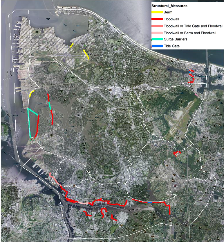
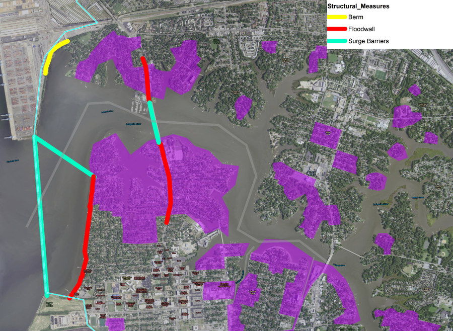
projects recommended by the US Army Corps of Engineers to reduce flooding over the next 50 years at Norfolk
Source: US Army Corps of Engineers, City of Norfolk Coastal Storm Risk Management Study (presentation to Norfolk City Council on May 23, 2017)
Among the proposed projects was an extension of the floodwall at Town Point north to West Ghent and east through Harbor Park to Grandy Village.
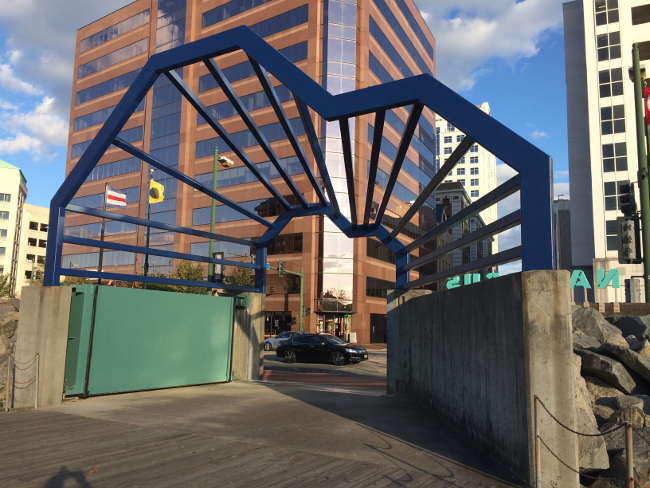
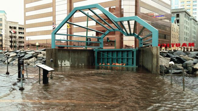
closing Norfolk's green floodwall gate (next to the USS Wisconsin) blocks water from entering the downtown district
Source: US Army Corps of Engineers, City of Norfolk Coastal Storm Risk Management Study (presentation to Norfolk City Council on May 23, 2017)
Four storm-surge barriers would be constructed so, at times of high water, structures would block the Elizabeth River from entering the Lafayette River, Broad Creek, Pretty Lake, and the Hague.26
the U.S. Army Corps of Engineers has recommended multiple ways to limit damage at Norfolk by predicted flooding
Source: US Army Corps of Engineers, City of Norfolk Coastal Storm Risk Management Study (presentation to Norfolk City Council on May 23, 2017)
at the Lafayette River, the U.S. Army Corps of Engineers has recommended constructing a temporary storm-surge barrier with a permanent floodwall on either side
Source: US Army Corps of Engineers, Norfolk Coastal Storm Risk Management
location of the proposed storm surge barrier across the Lafayette River, looking north to Norfolk International Terminals (NIT)
Source: US Army Corps of Engineers, Draft Integrated City of Norfolk Coastal Storm Risk Management Feasibility Study / Environmental Impact Statement (Figure 10-14)
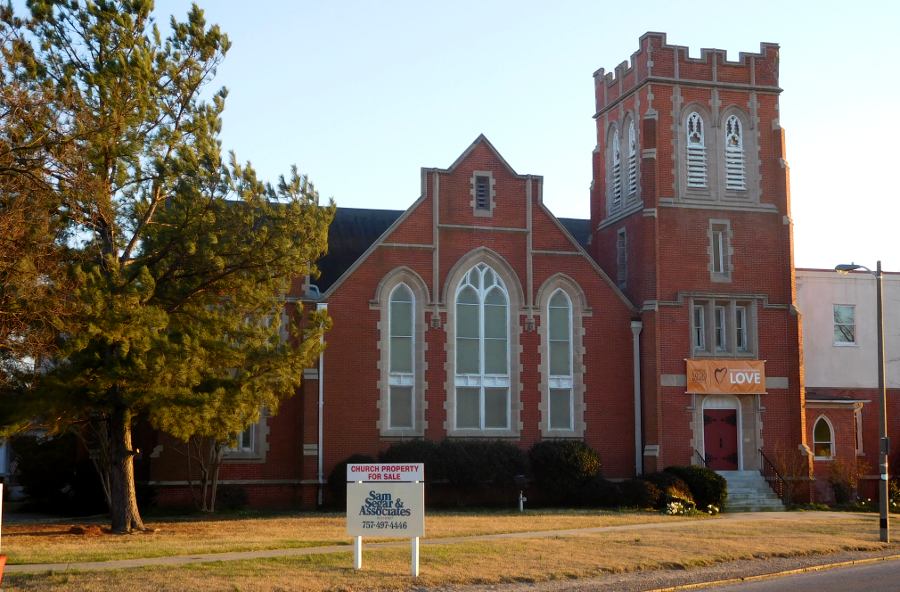
Norfolk is preparing for both adaptation and strategic retreat. The city is identifying neighborhoods along the Lafayette River that could be abandoned rather than protected by seawalls, and considering using city funds to purchase and destroy 20 homes near Norfolk State University. One church in the Ghent neighborhood was affected so often by high water that it added a link on its website to tidal flooding reports, and finally sold the building to move to higher ground.

during Hurricane Joaquin in October 2015, firefighters rescued a motorist next to the Unitarian Church of Norfolk
Source: US Army Corps of Engineers, Draft Integrated City of Norfolk Coastal Storm Risk Management Feasibility Study / Environmental Impact Statement (Figure 4.1)

the Unitarian Church of Norfolk in Ghent provided a tide chart as well as directions to the building, because high tides flooded the roads and blocked access
Source: Unitarian Church of Norfolk (UCN)
the Unitarian Church of Norfolk sold its building in Ghent and moved to higher ground at Military Circle, "retreating" from flooding
The Chrysler Museum spent $24 million to upgrade the facility in 2012-14, moving all electrical and other equipment out of the basement. In a later $30 million expansion of The Perry Glass Studio, resilience was a fundamental requirement. A large urban rain garden was designed to appear as a work of art, with a serpentine path followed by visitors to reach a new building constructed four feet higher. All the art kept in storage was moved up to the second floor. If the new floodgate is insufficient to keep water out, at least the challenge just before a flood event to protect the art will be reduced.
Norfolk was the third city in the world to hire a full-time "chief resilience officer," and local environmentalists have joked about the business opportunities:27
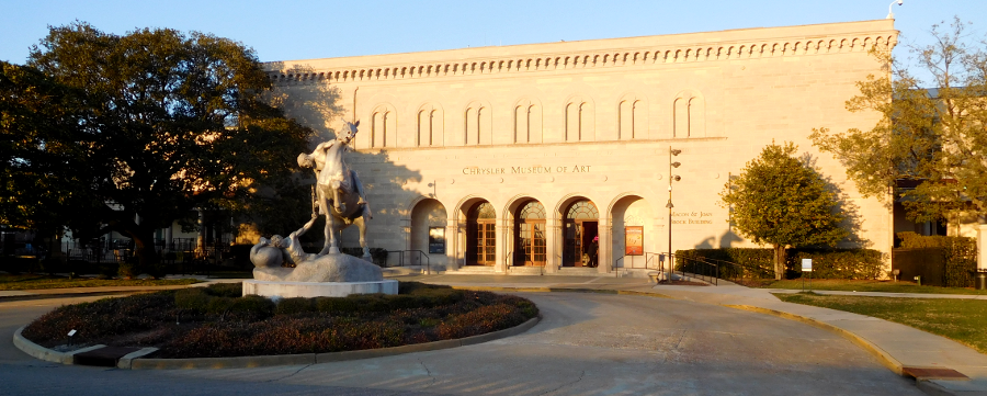
Chrysler Museum of Art in Ghent
Source: Chesapeake Bay Foundation, How Nature Alleviates Flooding
Miami Beach is already tackling the challenge, raising stormwater fees and installing 60 underground pumps to move floodwaters out of the city into Biscayne Bay. Increasing flooding during high tides (known locally as "king tides") was a major issue in the 2013 election for mayor. The storm drains were designed to carry rainwater from the land to Biscayne Bay, but were operating as two-way channels and transporting the bay's water during king tides to flood streets and low-lying sections of Miami Beach.
Pumping floodwaters back into the bay and adding barriers/valves in stormwater channels may be just a Band-Aid solution, delaying the inevitable need to retreat from the barrier island in the next century as sea level rises. The winning candidate contended that future innovations will provide answers to the current questions, commenting:28

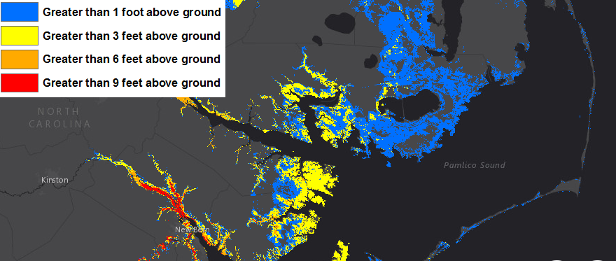
the coast in southeastern Virginia and North Carolina is vulnerable to flooding as sea level rises
Source: Greenhouse Effect and Sea Level Rise: America Starts to Prepare: Maps of Lands Close to Sea Level: North Carolina
Proposed responses to predictions of sea level rise propose a dramatic shift in how government agencies spend tax dollars and regulate development. Owners of shoreline and low-lying private property will be affected the most.
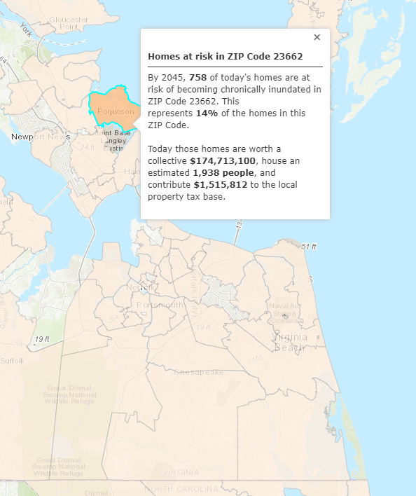
the Union of Concerned Scientists predicts houses at Poquoson will flood the most often in Hampton Roads by 2045
Source: Union of Concerned Scientists, US Coastal Property at Risk from Rising Seas
One study in 2018 calculated that home buyers were already reducing the prices they were willing to offer, for houses located in areas with increased flood risk. Between 2005-2018, real estate values in at-risk areas within Virginia were reduced by $280 million. In Hampton Roads, the greatest impact was not on the oceanfront at Virginia Beach. The inland city of Chesapeake was most affected, due to perceived risk of increased river flooding. Researchers noted:29
increased flooding has reduced home values most in the City of Chesapeake, as buyers consider tidal flooding risks even more than oceanfront storm surges
Source: ESRI, ArcGIS Online
The impacts of Hurricane Mathew on October 8, 2016 altered the political and bureaucratic dynamics in Virginia Beach. It was a 500-year storm, and portions of the city flooded after receiving 14 inches of rain. City officials had already initiated studies needed to prioritize upgrades to the 500 facilities that made up the city's stormwater management infrastructure, but funding allowed maintenance of each facility just once in 100 years.
Public support to "do something" shifted after Hurricane Mathew in 2016. The city increased taxes and fees and began planning a more-aggressive stormwater improvement program, including plans to raise even more revenue. One resident whose home was flooded described the change in public support for funding the upgrades:30
At the same time, a developer in downtown Norfolk announced plans to build more 272 new housing units on Waterside Drive between Atlantic Street and Commerce Place. The intersections on Waterside Drive flood during high tide events. The developer planned to build the first floor of apartments 12 feet above flood level, and commented:31
a developer announced plans in late 2019 to build 272 apartments where the adjacent intersections flood during "king tides"
Source: ESRI, ArcGIS Online
There is intense debate about proposed responses to deal with sea level rise, and even the need to take action now. Basic data continues to be refined. Worldwide risks of flooding were based on a digital elevation model that used data from a space shuttle Endeavor mission in 2000. An updated digital elevation model in 2019 increased by 70% the number of people at risk of being flooded by a high tide in 2100, particularly in China, Bangladesh and India.32
North Carolina has offered an alternative to strategic retreat or expensive investment. In the coastal region, landowners and local officials recommended that the state should reject predictions that sea level will rise significantly.
Twenty North Carolina communities banded together into the NC-20 coalition to oppose efforts by North Carolina officials to require preparations for a predicted 1-meter (39-inch) rise in sea level by 2021, as predicted by the North Carolina Coastal Resources Commission's Science Panel.
County officials feared state floodplain maps would be revised, requiring new roads/sewers/bridges to be constructed at higher elevations. The building industry feared revised maps would constrain new development on low-lying land.
The NC-20 coalition proposed that the Science Panel was wrong; assumptions about an increasing rate of sea level rise as glaciers melt were based on global warming scenarios that should be rejected. The coalition leaders conceded that sea level will rise, but disputed the rate - including the concept that Cape Hatteras marks the southern boundary of a "hotspot" with accelerated sea level rise, as ocean currents shift.
If insurance companies and government agencies in North Carolina make decisions based on predictions of sea level rise, current coastal area property values could be reduced dramatically over a wide area. To avoid considering the risk, the coalition claimed that the historical rate of sea level rise should be used to assume no more than an 8-inch increase in the next century.
The North Carolina legislature passed a law in 2012 prohibiting use of the latest climate assessments to calculate future flooding risks, and limiting risk assessments to 30-year predictions. As a result, official state and local data are now based on straight-line projections from the past rather than scientific calculations of the future. Potential impacts on 1,500 square miles were eliminated by passing a law and cutting assessment of the potential 39 inch rise in sea level to just 8 inches.33
Developers and North Carolina officials may have propped up land values temporarily, but the legislation will not alter how far the sea level actually changes. If the US Congress required 100% risk-based premiums for properties receiving insurance coverage through the National Flood Insurance Program, or if a major storm results in real-world flooding along the North Carolina coast, buyers may look beyond the NC-20 approach before determining what prices to offer when buying property at risk of flooding.
The law only affected official North Carolina reporting, and information from other sources regarding threats of flooding is readily available. For families interested in buying property that might be owned by future generations, Federal and non-government sources also can predict sea level rise and flooding risks for time periods longer than the next 30 years.
as Hurricane Florence approached in 2018, Federal agencies identified areas at risk (colors indicate where water height has about a 1-in-10 (10%) chance of being exceeded)
Source: National Oceanic and Atmospheric Administration (NOAA), Hurricane Florence
Virginia politicians must also deal with the organized groups who reject the science of predicted sea level rise. In 2012, when the General Assembly funded a study of potential impacts of coastal flooding (which will be used to request Federal funding), the legislators referred to recurrent flooding and to omitted the buzzwords of climate change and sea level rise. The Virginia Department of Environmental Quality (DEQ) refers to coastal resilience when dealing with the impacts of increasing sea levels, bypassing the political debate in order to focus on the response.34
proposed hardening of shoreline and pumps to protect against coastal flooding/tidal surge at The Hague, near Ghent neighborhood in Norfolk
Source: City of Norfolk, Coastal Flooding Mitigation (presented to Expert Advisory Panel, February 16, 2012)
In addition to Virginia Beach and the Eastern Shore, other jurisdictions inland from the Atlantic Ocean will be affected if predicted sea level rise occurs. At some point Norfolk will be abandoned, the ruins of the city will lie underneath sediments accumulating on the continental shelf, and the Coastal Plain will be flooded further inland.
The Chickahominy River water supply for Newport News could become more saline, increasing the cost for the utility to produce drinking water for the area. In 2011, the US Geological Survey assessed potential impacts and determined:35
Since 1900, sea level at Jamestown Island has risen 1.5 feet. In another 100 years, sea level is predicted to rise another three feet - and in 2021, the 1,500 acre island was less than three feet above sea level.
The risks to existing places are exacerbated by greater precipitation. Annual rainfall has increased on average 0.5" each decade since 1895. What was once a pine-forested island is changing. Since 1990, the field where Captain John Smith drilled his troops at the founding of Jamestown (and the site of a brick furnace that presumably fired the bricks for the still-standing church tower) has transformed. A field once dry enough to grow corn is now constantly wet. Nearly one-third of the 22 acres owned by Preservation Virginia have morphed into a wetland.
The extra groundwater, not the rising waters of the James River, is weakening the structure built in 1900 to stop erosion. By 205, the National Park Service calculates that only two archaeological sites on Jamestown Island will be entirely above water. There are already known sites which can no longer be excavated due to the higher water table.36
At the 500th anniversary of the English colonial settlement at Jamestown in 2107, the historic old capital of Virginia might be a barrier island, a mud flat, or fish habitat.
The water table in Tidewater is rising as the wedge of seawater pushes westward. A seawall at Jamestown might block a storm surge like the one from Hurricane Isabel that flooded the visitor center/museum and caused $20 million in damages, but groundwater levels will rise high enough to flood the site in 50-100 years. Archeologists traditionally leave some areas unexcavated, waiting for new scientific techniques to be developed, but are now suggesting all artifacts at Jamestown should be removed soon. One climate scientist from the Virginia Institute for Marine Science (VIMS) expects Jamestown to disappear in a century:37
unless the National Park Service builds floodwalls, Jamestown Island is likely to be a wetland or underwater in 2107
Source: Virginia Institute of Marine Science (VIMS), Sea Level Rise Planning Maps
Despite predictions of sea level rise, banks continue to grant 30-year mortgages and public officials continue to construct new infrastructure within the area predicted to be underwater within the next century. No one has repeated the dedication given by a local Dorchester County (Maryland) official in 1980. He was offended by the excessive cost and design standards for a replacement bridge linking Hoopers Island to the Eastern Shore. He shocked listeners and gained a brief moment of national fame with the words of the prayer that he offered, at ceremonies for opening the bridge:38
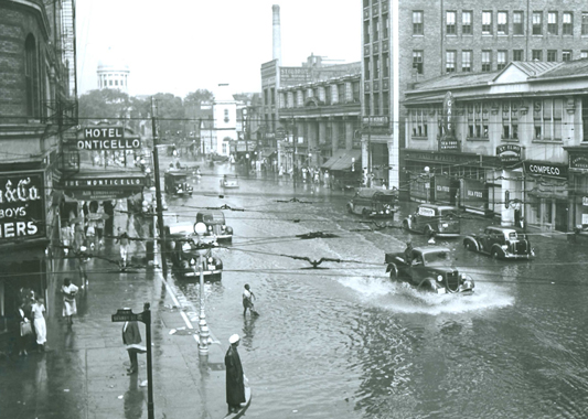
flooding in Norfolk, 1933
Source: City of Norfolk, Photo Album
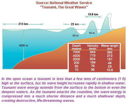
In 2006, Norfolk became the first East Coast city to earn recognition by the National Oceanic and Atmospheric Administration (NOAA) as "TsunamiReady/Storm Ready." According to the local paper, the city official responsible for disaster preparedness:39
In fact, a tsunami did strike the East Coast on June 13, 2013, triggered perhaps by a landslide off the New Jersey coast or by air pressure changes associated with a localized "derecho" storm. Three people were swept off a jetty in New Jersey into the ocean from rocks that were 5-6 feet above sea level. Further south on the Eastern Shore of Virginia at Kiptopeke, the water gauge recorded an increase in water height 25 centimeters (10 inches) above average. That change was one of the highest recorded from the unusual event, but at Chesapeake Bay Bridge-Tunnel the increase was only 7 centimeters.40
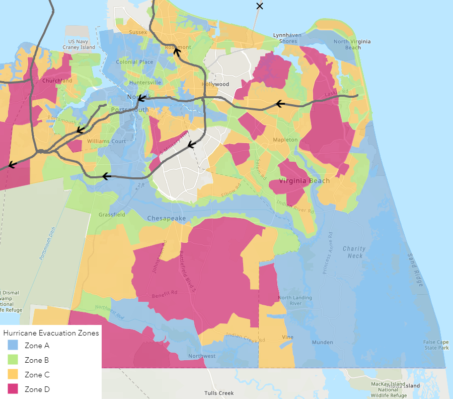
Virginia has adopted four color-coded evacuation zones, with blue being the first zone to flee
Source: Virginia Department of Emergency Management, Virginia Hurricane Evacuation Zone Lookup Tool
In 2020, the Chesapeake Bay Foundation abandoned its educational facilities and sold Fox Island in the Chesapeake Bay, between Tangier and Pocomoke sounds. Educational programs there had been stopped in 2019, shifted instead to Port Isobel. Due to sea level rise and the disappearance of protective barrier islands and marshes, the organization feared that the island would be unsafe during a storm.
Fox Island had been a complex of seven or eight islands when originally surveyed in 1773, totaling 426 acres of land. By 2020, it had shrunk to 34 acres of land.41
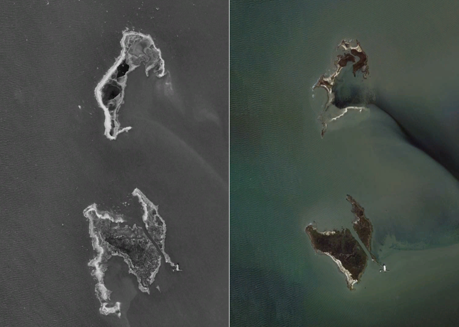
Fox Island in 1994 and 2015
Source: Google Earth
The General Assembly passed legislation in 2021 so Virginia could join the Regional Greenhouse Gas Initiative (RGGI) in 2020. The General Assembly failed to act on joining the Transportation and Climate Initiative to constrain emissions from vehicles, but in the debate a State Senator from Northern Virginia commented:42
After joining the Regional Greenhouse Gas Initiative (RGGI), major producers of greenhouse gas emissions purchased allowances in quarterly auctions for each ton of carbon they emitted in Virginia. In 2021, the first year of auction payments, Virginia received $228 million. The General Assembly directed 50% of that funding for low-income energy efficiency programs and 45% for a Community Flood Preparedness Fund. The remaining 5% covered administrative overhead.
However, the 2021 elections shifted political power in the state. Glenn Youngkin, the Republican candidate, was elected governor. He announced plans to pull Virginia from the Regional Greenhouse Gas Initiative (RGGI), claiming that he had the authority to withdraw by issuing an executive order. Such an action would dramatically reduce funding for the Community Flood Preparedness Fund.43
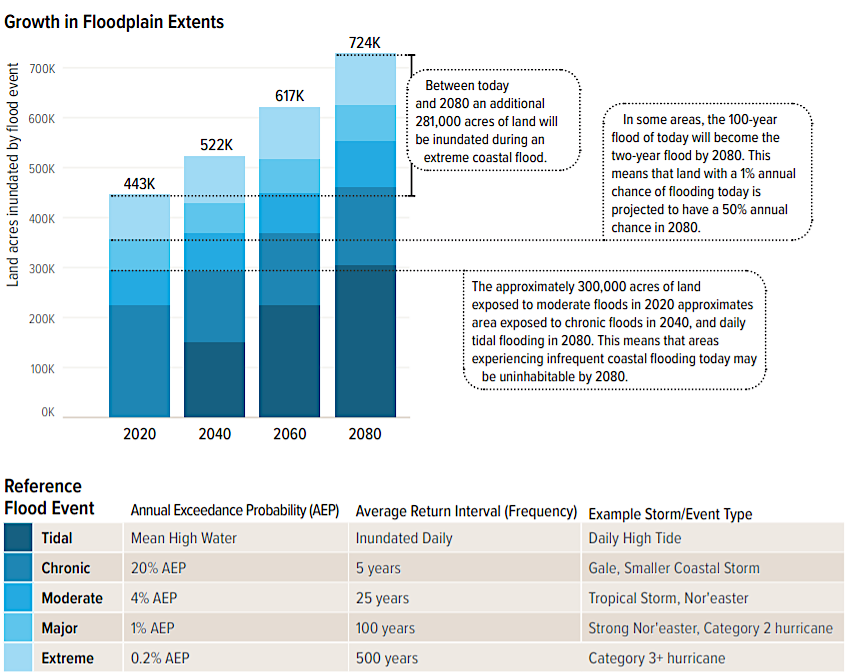
The state identified in 2021 where flooding was the greatest risk. The first Virginia Coastal Resilience Master Plan concluded that between 2020 and 2080:44
The Chrysler Museum is located at "ground zero" for Elizabeth River flooding in Norfolk, where Smith Creek drains into The Hague. The 2024 addition to the Perry Glass Studio, a $30 million investment, was designed to cope with increasing Smith Creek runoff and sea level rise:45

the 2024 addition to the Perry Glass Studio is four feet higher, part of its flood resilience design
Source: Work Program Architects, Perry Glass Studio
The FY2022 annual work plan of the U.S. Army Corps of Engineers included $250 million for Norfolk to begin work on a $1.6 billion flood control project. If completed, Norfolk would use storm surge barriers, tidal gates, eight miles of floodwalls, levees and pump stations to protect the downtown area.
The focus was to protect a portion of Norfolk from a storm surge, using concrete and earth barriers. Since the new flood control structures would trap rainwater inside, causing some observers to draw a comparison with a bathtub, pumping stations that required a reliable supply of electricity were essential to reduce flooding triggered by heavy storm rainfall.
The flood control project, initially estimated to cost $1.6 billion, was based on the assumption that the city could be preserved as an island surrounded by walls, with little focus on "green vs. gray" solutions such as strategically abandoning the at-risk shoreline areas and planning for them to flood.
Federal funding was targeted towards the sea wall solution. Owners of existing waterfront property resisted the alternative - tearing down existing buildings generating revenue now in exchange for protection against sea level rise that was predicted to occur over future decades. Removing existing development would be expensive, though the newly-created green spaces along the waterfront would create a recreational amenity for Norfolk.
One concern was how the water blocked from flooding Norfolk might affect Portsmouth. If a Norfolk floodwall diverted the waters westward to the other side of the Elizabeth River, then Portsmouth might experience even greater flooding impacts. A researcher at Old Dominion University identified how actions taken by the more-wealthy Norfolk could be detrimental to Portsmouth:46
By 2025, the Norfolk Coastal Storm Risk Management Project was estimated to cost $2.7 billion. Completion was planned in 2037. The project included levees, floodwalls, and three floodgates, or storm surge barriers, across the Lafayette River, Broad Creek and Pretty Lake in Ocean View. The Lafayette River is one mile wide where it would be enclosed by a floodgate. Placing barriers 12' high at the mouths of the three waterways would impede navigation and fish migration, affect scenic vistas, and potentially trap pollution, but would minimize costs of building levees and floodwalls on much longer stretches of shoreline.
After hurricane damage in 1938 and again in 1954, a hurricane barrier was completed in 1966 to protect the harbor at New Bedford in Massachusetts. It includes a 4,500-foot-long earthen dike as much as 20 feet high that was protected from erosion by large stone blocks), plus three other long extension dikes that are 20-23 feet high. A 150-foot-wide gated opening on the water facilitates navigation.
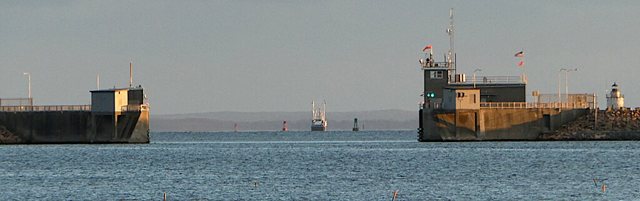
the surge protection barrier at Bedford, Massachusetts includes an opening for boats to access the harbor
Source: ESRI, ArcGIS Online; Wikipedia, Acushnet River
Residents living on the southern bank of the Elizabeth River opposite Harbor Park complained that no floodwall was proposed to protect their neighborhood. The historically-black area had lower property values but construction costs were still high, so the cost-benefit ratio for protecting property was too low. Instead, the US Army Corps of Engineers proposed non-structural alternatives to reduce the impact of flooding.
More-wealthy residents in the Freemason community west of Town Point Park had the opposite concerns. They objected to the initial design of a proposed 16' high floodwall on their shoreline. Reducing the impact of flooding would avoid catastrophic loss, but sealing off the waterfront and blocking viewsheds would reduce property values.
Freemason residents sought alternative techniques to prevent flooding, or moving the floodwall further into the Elizabeth River. City officials used their obligation to provide 35% of the funding as leverage. The city manager said:47
a proposed 16' high floodwall would block views of the Elizabeth River from the Freemason neighborhood
Source: Resilient Norfolk Coastal Storm Risk Management Project, Phase 1C East: Freemason and Front Street Area Alternatives Synthesis (p.29)
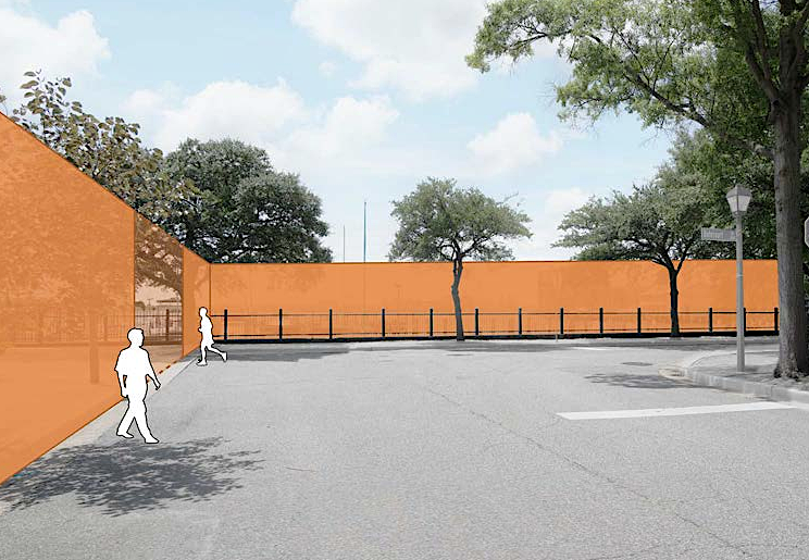
Nearly nine miles of floodwall was planned to protect Norfolk, stretching from east of the casino at Harbor Park to Lamberts Point. The first component of the Norfolk Coastal Storm Risk Management Project, Phase 1A, was a floodwall between 6.5-16.5 feet high extending from the Berkley Bridge to Harbor Park. Looking south from the city, people would see a green berm. Looking north from the waterfront, the view would be of large rocks sloping up to the top of the berm. A living shoreline was planned at the edge of the water.48
The estimated cost of the floodwall climbed from the original proposal of $1.4 billion to $2.66 billion, and then in 2026 to $6.1 billion. Unless the US Congress changed the requirements and lowered the city's share, its cost would be $2 billion. A study by the General Assembly to constribute state funding was not due to be completed until 2028. Unless accelerated, Norfolk's first opportunity to advocate for substantial financial assistance from the state would be the 2029 General Assembly.49
to
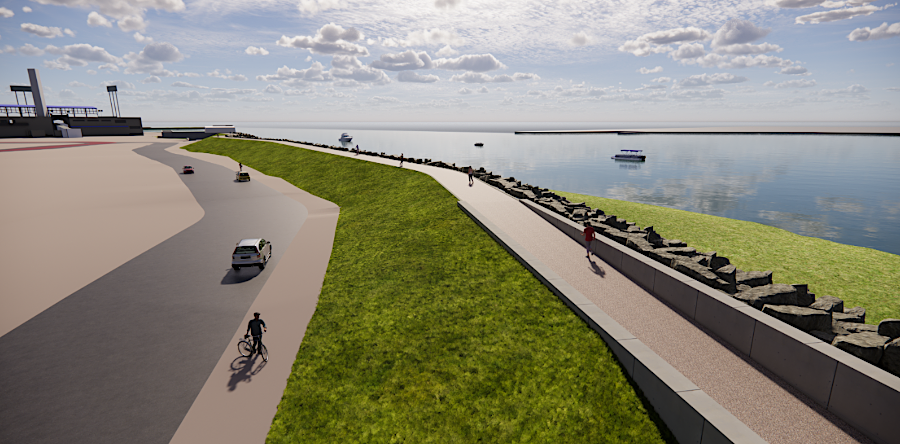
the Harbor Park Levee, planned to terminate at the casino, would include a trail on the top
Source: Resilient Norfolk Coastal Storm Risk Management Project, NCSRM Conceptual Renderings
Phase 1A & 1B
In 2022, Norfolk became the pilot site for use of a new flood mapping tool designed to help drivers avoid flooded streets. In the United States, half of deaths due to flooding occurred in vehicles.
The FloodMAPP/WAZE app on smartphones provided real-time information, updated every 15 minutes, showing where roads were covered by six inches of water. Drivers in Norfolk were aware that streets could accumulate a foot of water quickly in a rainstorm, but needed a tool to identify which streets were dangerous vs. passable.50
the Virginia Coastal Resilience Master Plan quantified in 2021 how rising sea levels will have significant and expensive impacts on coastal areas of Virginia
Source: Virginia Department of Conservation and Recreation (DCR), Virginia Coastal Resilience Master Plan - Phase One (p.X)
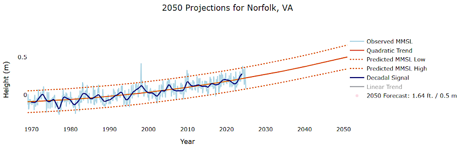
the Virginia Institute of Marine Science (VIMS) predicts a steady rise in sea level, with different possibilities for the rate
Source: Virginia Institute of Marine Science (VIMS), VIMS Sea-Level Report Cards Dashboard

Granby Street, flooded in 1933
Source: Norfolk Public Library Norfolk Historical Images