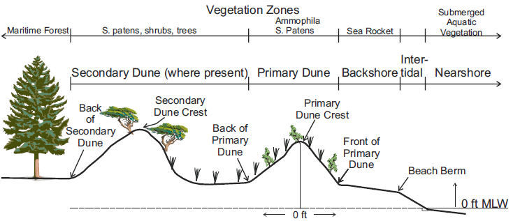
Typical Chesapeake Bay Dune Profile
Source: Virginia Institute of Marine Science, Chesapeake Bay Shoreline Evolution Reports - Accomack County (Figure 6)
Typical Chesapeake Bay Dune Profile
Source: Virginia Institute of Marine Science, Chesapeake Bay Shoreline Evolution Reports - Accomack County (Figure 6)
The US Congress passed the Coastal Zone Management Act in 1972. It affects 29 counties, 15 cities, and 42 towns in Virginia, plus state waters stretching out to the three mile Territorial Sea boundary. Nationwide, 127 million people - 40% of the US population - line in counties on the coast.1
Virginia and the Federal government have different definitions of where sand dunes within the coastal zone deserve special protection.
State law uses geologic criteria to define where sand dunes are protected - "to the line of woody vegetation (usually the effective limit of stormwaves)" or "the nearest impermeable man-made structure." The state's Chesapeake Preservation Act defines a 100-foot buffer of land along the shoreline with limited development rights. Parcel boundaries of private ownership are not a factor in either definition, though property boundaries might have been be used when landowners built the nearest impermeable man-made structure.
The Federal Coastal Barrier Resources System ended up being specific parcels of land. For the Federal system, boundaries were based on land ownership as well as natural features.
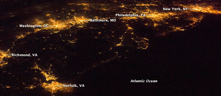
lights at night reveal how the coastline of the Eastern Shore is undeveloped
Source: National Aeronautics and Space Administration (NASA), Earth Observatory
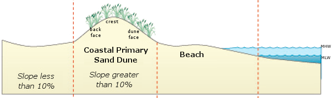
The Virginia General Assembly passed the Coastal Primary Sand Dune Protection Act of 1980 to protect natural sand dunes. It established standards for use of coastal primary sand dunes, as well as the legal definition for beach and sand dune:2
Many Tidewater counties have established Wetland Boards to review proposed land use changes or construction in wetlands and on shorelines. The Virginia Marine Resources Commission also has authority to review projects:3
jurisdiction for Virginia Marine Resources Commission to review beach/dune projects
Source: Virginia Institute of Marine Science, Sand Dune and Beaches in Virginia: Science and Management (Fall 2009, Special Issue of Rivers and Coast)
The Virginia Marine Resources Commission enforces the law, but local Wetlands Boards hear proposals first. In the city of Norfolk, the local Wetlands Board was sympathetic to the concerns of residents living along the Chesapeake Bay waterfront at Ocean View in Norfolk, after dunes migrated in front of their homes and blocked the view. Homeowners claimed the sand moved after the city removed fencing along the beach, and requested authorization to lower the dunes and reshape them so the dunes would be wider.
The homeowners lived in a portion of Ocean View that was not located in a 100-year flood zone. Unfortunately for them, however, the city was proposing an $18 million project to widen a 7-mile stretch of the beach at Ocean View by 60 feet, in order to reduce the risk from flooding during a hurricane. Protecting the dunes was part of the city's plan, which included convincing the Corps of Engineers to contribute over $10 million.
After the Wetlands Board approved the request to modify the dunes, the local Wetlands Watch environmental group appealed the decision to the Virginia Marine Resources Commission. That state agency could override the local Wetlands Board, with its authority to enforce the Coastal Primary Sand Dune Protection Act.5
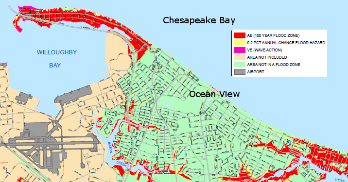
in 2013-14, dune modification was proposed by landowners in Ocean View who were located outside the 100-year flood zone
Source: City of Norfolk, Flood Insurance Rate Map

the Coastal Zone Management Act affects 29 counties, 15 cities, and 42 towns in Virginia
Source: Virginia Department of Environmental Quality (DEQ), Coastal Zone Management Boundaries in Virginia