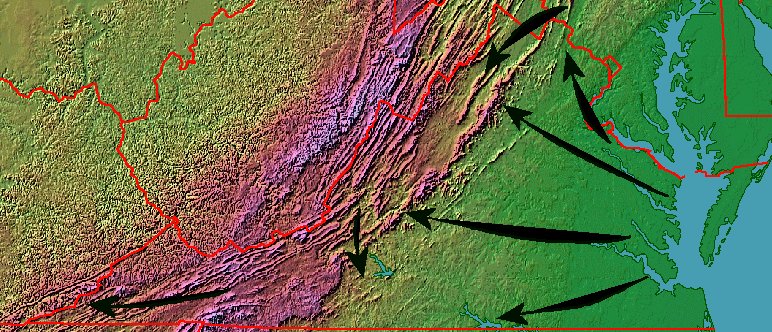
European migration into Virginia (note the arrow from Pennsylvania into the Shenandoah Valley)
The best evidence still suggests that the ancestors of the first immigrants to Virginia crossed the Bering land bridge 15-20,000 years ago. It is possible that the Native Americans met by the Spanish and English in the 1500's also included descendants of people who had paddled across the Atlantic Ocean and arrived from the east.
The traditional story is that Virginia was settled from the west, by hunter/gatherers who walked up river valleys and across mountain ridges while hunting and gathering food. Those first settlers crossed what we now call the Mississippi River and entered what we now call Virginia. They arrived long before there were kings or queens in England, long before anyone named Columbus sailed westward towards India/China, and long before the current names of places in North America were assigned by immigrants who have arrived over the last 500 years.
The last year in which 100% of the residents of Virginia were born in North America was 1606. In 2015, 11.7% of the population in the state was born in a foreign country. About half of those were naturalized citizens.1
While the original settlement of Virginia is still unclear, we know that European settlement into Tidewater and Piedmont Virginia came from the east. In the Shenandoah Valley and the rest of the Valley and Ridge physiographic province stretching to Cumberland Gap, most European settlement arrived from the north rather than the east. Immigrants arriving in Philadelphia chose to migrate south into Virginia's Shenandoah Valley
The barrier of the Blue Ridge was a factor limiting migration westward from the Piedmont prior to the 1760's, but the mountain range was not the only cause. Much of the Piedmont was still only lightly settled prior to the start of the French and Indian War in 1755. There was no need to cross the mountains to cut a farm out of the wilderness, so settlement from the east was not constrained by the Blue Ridge when the Scotch-Irish and German immigrants moved into the vallleys to the west.
European migration into Virginia (note the arrow from Pennsylvania into the Shenandoah Valley)
Some of the settlers who walked from Philadelphia into the Shenandoah Valley, then further south, chose to cross back to the east side of the Blue Ridge at modern-day Roanoke. They reached the Piedmont west of Lynchburg, in territory still unoccupied by settlers slowly carving farms out of the river valleys west of the Fall Line. Some of the settlers who walked east through the Roanoke River gap kept moving south, and occupied the Piedmont of North Carolina.
For example, Daniel Boone's family, and the Moravians who initially settled Winston-Salem, migrated through that gap at Roanoke on their way to the Yadkin River valley in North Carolina. Later, Boone explored westward, leading hunters and settlers through Cumberland Gap into Kentucky. The Great Wagon Road south of Roanoke was extended, becoming the Wilderness Road and (today) I-81.
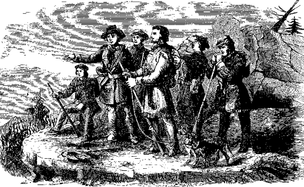
Daniel Boone looking beyond the Cumberland Gap into western Virginia (formed later into the Commonwealth of Kentucky)
Source: Cecil B. Hartley, Life & Times of Col. Daniel Boone, Boone's First View Of Kentucky
As far back as the 1720's, Governor Spotswood purposefully encouraged settlement of the Shenandoah Valley by non-English immigrants. When Spottwood started serving as governor, the Piedmont (east of the Blue Ridge) was just being settled by immigrants from England. The English immigrants developed farms between the Fall Line and the Blue Ridge, but settlement was moving slowly upstream into the Piedmont and not sweeping westward over the Blue Ridge.
Spotswood feared the French were occupying lands just to the west of the Blue Ridge, moving down from Canada into the Ohio River Valley. If there was a war between France and England in European, that conflict could expand across the Atlantic Ocean. An attack by French and their Native American allies on the frontier settlements in English-controlled Virginia was a possibility that needed some sort of response from the colonial governor in Williamsburg.
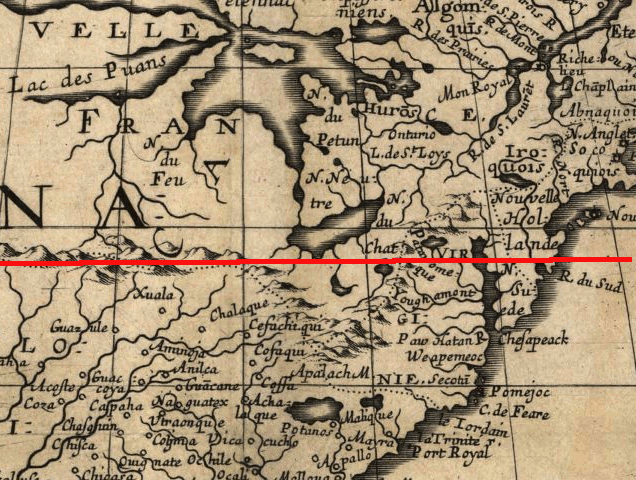
1650 map showing Lake Erie to be south of 40th degree of latitude - but it is a degree further north
(red line is approximate location of the 40th parallel, so Spotswood thought the French were much closer to Virginia and a greater threat...)
Source: Library of Congress, Am rique septentrionale
Spotswood had bad maps. He thought the French forts on the Great Lakes were less than a 1-week march from the Blue Ridge. Governor Spotswood identified the most likely military threat to the western frontier of Virginia to be from the French in the Mississippi and Ohio River valleys, just as a century earlier the first colonists at Jamestown had considered the Spanish and other European rivals to be the most significant military threat. If the French forces in Canada and the Ohio River Valley allied with hostile tribes, they could block English settlement at the Blue Ridge - and even threaten settlements in the Piedmont.
The first European country to occupy lands between the Blue Ridge and the Ohio River would control that territory. Spotswood recruited Germans and Scotch-Irish who arrived at Philadelphia to settle in Virginia, between the Blue Ridge and the French. The first colonists to settle Virginia west of the Blue Ridge walked from Philadelphia into the Shenandoah Valley, where they established settlements that would serve as a buffer and a trip wire to alert the Virginians about western incursions. (Spotswood's concerns were validated in the 1750's, when settlements in the Valley and Ridge province from Winchester to the New River were attacked during the French and Indian War.)
Some English-descended colonists crossed the Blue Ridge from the east, settling in the Shenandoah Valley. The English-dominated eastern edge of Frederick County ultimately separated and became Clarke County, and the culture of the two counties is distinctly different even today. By the time the Anglicans from the east crossed the Blue Ridge, the culture of the Shenandoah Valley was already dominated by the Scotch-Irish and the Pennsylvania Deutsch ("Dutch") immigrants. The Scotch-Irish established Presbyterian churches. The Pennsylvania immigrants established Lutheran, Brethren, Dunker, and Mennonite churches.
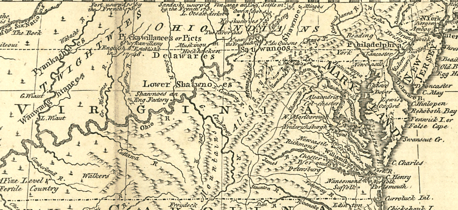
prior to the French and Indian War, almost every place on the map west of the Blue Ridge was Native American or French
Source: Library of Congress, A map of the British and French settlements in North America (1755)
European culture has spread completely across Virginia and the North American continent in the last 400 years. The "frontier" of settlement, the line between territory that was settled and land that was "unsettled" (except by Indians), was no longer obvious by the 1890 Census.
However, for the first 200 years of colonization, most of the immigrant (colonist...) population lived near the Atlantic Ocean. Settlers were slow to move inland from the Atlantic Ocean coast because ships could no longer provide easy transport for agricultural exports, once settlers moved further west past the Fall Line.
Half of all the people in America lived east of the new capital of Washington DC when it was founded in 1800. Transportation by wagon was far more expensive than shipping directly from a Tidewater wharf, so farmers living west of the Fall Line spent much of their "profit" on the cost of getting their goods to port cities such as Charleston, Alexandria, Baltimore, Philadelphia, and New York.
From 1810-1850, the mean center of population for the United States was located in Virginia. It moved from 39 degrees 11 minutes 30 seconds latitude, 77 degrees 37 minutes 12 seconds longitude in Loudoun County in 1810 to 38 degrees 59 minutes 00 seconds latitude, 81 degrees 19 minutes 00 seconds longitude near Parkersburg, Virginia (now West Virginia) in 1850. Only in 1860 did the center of population move west of Virginia, across the Ohio River.
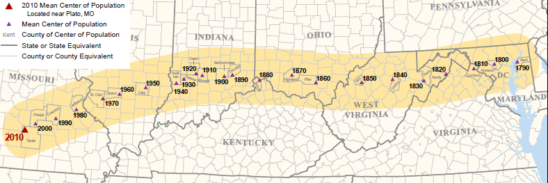
as population migrated and grew westward, the mean center of population moved west, new states were created - and Virginia's political influence waned
Source: Bureau of Census, Mean Center of Population for the United States: 1790 to 2010
The failure of the Americans to settle Mexico or the prairies of Canada shows that "Manifest Destiny" is no guarantee that settlement to the west would be successful. If the French had succeeded in occupying the Ohio River valley, establishing a line of settlements from New Orleans to Quebec and restricting the British to a strip on colonies along the Atlantic Ocean, then today's dominant language in the "heartland" of North America might not be English.
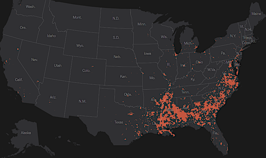
areas where the population is currently at least 20% African-American
Source: New York Times, How a Nation of Immigrants Traces Its Roots (July 1, 2026)