the first people in Virginia arrived about 15,000 years ago
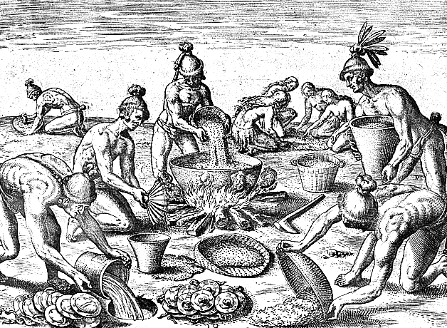
Source: Theodore De Bry Copper Plate Engravings - Native Americans Preparing for a Feast
the first people in Virginia arrived about 15,000 years ago
Source: Theodore De Bry Copper Plate Engravings - Native Americans Preparing for a Feast
Virginia has a diversity of people, people who came from different places and cultures dating back 15,000 or so years.
When the first Paleo-Indian hunting bands arrived, they probably shared many common characteristics. As the environment shifted at the end of the Ice Age, different groups emerged with different ways of shaping stone into tools, and different ways of obtaining food.
There was no single moment in time when all Native Americans were the same. Different traveling bands chose at different times to start growing crops and to occupy settled towns for longer periods. Different groups established distinctive religious and political practices, in different places and at different times.
For example, the mound-building culture left evidence of their presence west of the Blue Ridge and in the Rivanna River valley, but not on the Coastal Plain. The mound builders apparently never have tasted fresh clams and blue crabs, though they may have traded for smoked oysters.
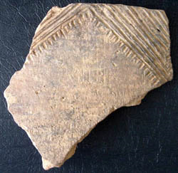
Archaeologists can document how the patterns of people changed over the last 3,000 years in the Woodland Period by looking at changes in pottery. All pottery was made with local clay, but some groups used sand vs. crushed shell as "temper." That ingredient was needed to help moisture escape as the clay was heated into pottery; without a temper, the pots would crack. The exterior of pottery was smoothed with different tools and decorated differently. As a result, even tiny shards of broken pottery at an archaeological site can identify changes in who lived there.
Native American pottery from Little Falls, on Potomac River
Source: National Park Service, Archeology and History in Rock Creek Park
One challenge for archaeologists is assessing the speed of technological changes. Technology changes occurred gradually within an existing society, and quickly if a group of strangers attacked and displaced the old occupants of a territory. A third option exists as well. If a few people moved into a community, perhaps women captured from another group after a raid, then new ideas could have been introduced and new forms of pottery produced together with old-style pots.
When the Europeans arrived, there were distinct tribes different languages and different lifestyles. They were competitive with each other in some areas; that is why the Europeans discovered Native American villages with palisades.
The English recognized those differences from the beginning and sought to exploit the rivalries. They bypassed Powhatan's efforts to control the food supply by sailing on the Chesapeake Bay to trade with less-allied tribes on the Potomac River and the Eastern Shore.

Pocahontas Saving the Life of Captain John Smith
(clearly not historically accurate - notice the teepees in the background)
Source: State Department, Telling America's Story
At other times, the English treated all Native Americans equally. In Bacon's Rebellion, the Susquehannock and Dogue were attacking settlers in the backcountry, but Nathaniel Bacon led his army against the peaceful Occoneechee and Pamunkey.
In 1607, there may have been 13,000 Algonquian-speaking Native Americans within the Coastal Plain territory claimed by Powhatan, and 15,000 Siouan-speaking Monacans/Manahoacs in the Piedmont. The separation of the two groups dates back to 200 A.D., based on archaeological studies that identify when the "shared ceramic tradition" east and west of the Fall Line diverged and different pottery types emerged.1
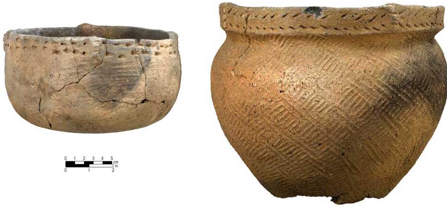
different tempers, rim styles, and smoothing patterns indicate changing Native American populations during the Woodland Period
Source: University of North Carolina - Research Laboratories of Archeology, The Woodland and Mississippian Periods in North Carolina
Additional Algonquian-speaking Native Americans lived north of the Rappahannock River watershed outside of Powhatan's control. There was an unknown number of a Siouan-speaking groups such as the Monacan, Manahoac, Occaneechi, and Saponi living west of the Fall Line.
Iroquoian-speaking groups lived in the Blackwater River and Nottoway River watersheds. Just across what would become the Virginia-North Carolina border lived the Tuscarora along the Roanoke, Neuse, Tar, and Pamlico rivers.
The Iroquoian-speaking Cherokees lived in southwestern Virginia. At the time the Europeans arrived, total Native American population may have been 50,000 people within the boundaries of what is now Virginia.2
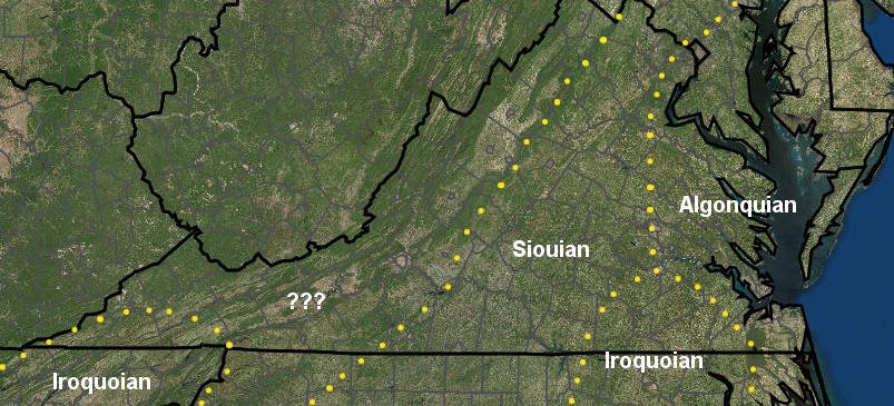
at the time of European Contact, Native Americans in Virginia used three different groups of languages
Source: ESRI, ArcGIS Online
The earliest European settlers in Virginia were not homogeneous either. The first colonists from England came from different cultures within that country, and then from other nations. Some were poor men looking for a steady wage from the Virginia Company, willing to accept a term of service as an indentured laborer in order to have the opportunity to own land in Virginia. Others were "gentlemen," already-wealthy venture capitalists who adventured their person and risked their health in the new colony (as well as their wealth).
Cultural conflict in early Jamestown was deadly. Powhatan sought to limit the potential expansion of the colony, killing most of the English who hunted or explored far from the fort. Within the colony, the rivalries were equally intense. George Kendall was executed after the Council determined he was a spy supporting the rival Catholic kingdom of Spain.
Despite resupply ships bringing new settlers, Virginia's immigrant population grew slowly after 1607. Some immigrants to America returned to England, such as John Smith in 1609, but most early colonists died from starvation, disease, or in conflicts with Native Americans such as the 1622 uprising.
Population estimates in the colonial period vary; a standardized census approach was not established until 1790. Natural increase was minimal until the Virginia Company began to send boatloads of women in 1619. Deaths and returns back to England almost matched immigration until after Virginia became a royal colony when the Virginia Company charter was revoked in 1624:3
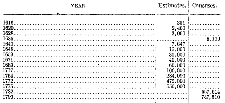
in 1616, there were just 351 English colonists in Virginia
Source: Bureau of Census, Population in the Colonial and Continental Periods (p.7)
Colonization did not move inland initially. Instead, new farms were established in eastern Virginia along the navigable portions of rivers that flowed into the Chesapeake Bay. Settlement expanded upstream to the Fall Line on the James, York, Rappahannock, and Potomac rivers throughout the 1600's. Moving westward, across the Fall Line, was delayed to the first decades of the 1700's.
Settlers displaced Native Americans first along the James River. After the 1622 uprising led by Opechancanough (the Second Anglo-Powhatan War), colonists built a wall between the James and York river to exclude Native American settlements from most of the Peninsula.
The Third Anglo-Powhatan War led to the defeat and assassination of Opechancanough. His successors signed a 1646 treaty that in theory reserved lands north of the York River for Native Americans, but that boundary was soon broken.
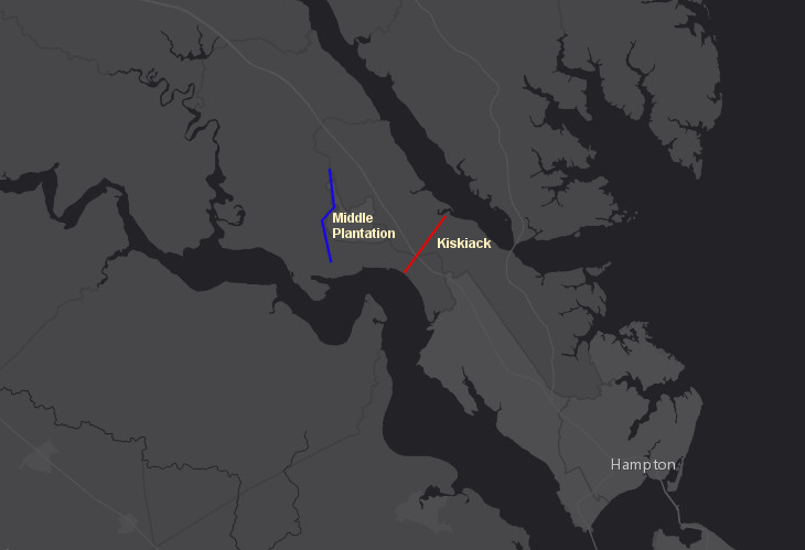
a barrier between Martin's Hundred and Kiskiack was proposed in 1624 (red line), but the wall built in 1634 (blue line) enclosed more acres on the Peninsula
Source: location of 1634 palisade from Phillip Levy, A New Look at an Old Wall. Indians, Englishmen, Landscape, and the 1634 Palisade at Middle Plantation
Starting in 1619, Africans became part of the cultural mix in Virginia. The best way to grow wealthy in colonial Virginia was to grow more tobacco, but tobacco quickly exhausted the nutrients in the soil. Farmers required large supplies of labor to clear forests to plant new fields, then to weed, harvest, dry, pack, and transport hogsheads filled with tobacco leaves.
The Virginia colonists were unable to get that labor the local Native Americans, unlike the Spanish in Mexico and Peru. The initial solution was to recruit settlers from England and Europe. Through the headrights system, the colonial government gave 50 acres of land to anyone willing to recruit and bring a new immigrant to Virginia.
Land in Virginia was cheap and readily available after displacing the Native Americans, but workers willing to work in the fields were scarce and valuable. After the end of the English Civil War, the supply of indentured servants from England was inadequate. The solution chosen by the colonists was to find a supply of workers who did not have a choice and could be forced to perform labor at minimal cost.
During the second half of the 1600's, the English colonists established a cultural and legal basis for slavery. Discrimination based primarily upon skin color was legalized. The labor force was increased in the 1700's by importing slaves from Caribbean islands, after Africans transported cross the Atlantic Ocean had lived through a period of "seasoning" and proven resistance to disease.
Virginians created a system of slavery that required anyone born to a slave mother to spend their entire life as a slave, unless the master emancipated the slave and granted freedom. As tobacco exhausted the nitrogen and other nutrients from the soil, farmers abandoned Tidewater lands and carved new plantations in the Piedmont. North of the James River, farmers found more growing wheat and other grains to be more profitable than tobacco. South of the James River, tobacco remained the money crop.
Virginians re-considered the concepts of liberty and slavery during the American Revolution, but only a few slaveowners chose to free their slaves. The economics of plantation agriculture, not matter what crops were grown, depended upon both cheap land and cheap labor.
The colonists who advocated for personal liberty and independence in the 1770's chose to protect the rights of just those people defined as being "in a state of society," excluding people of color. Virginia slaveowners ensured that their newly-independent state, and then their new Federal union with other states, preserved the institution of perpetual slavery.
Virginia farmers had not fertilized or added lime to their soils, and productivity in the early 1800's was low. At the same time, the population of enslaved men, women, and children expanded by natural increase, so there was an imbalance between the need for labor vs. the availability of labor. Thomas Jefferson and others realized that they could make more of a profit by raising and selling slaves than by raising and selling agricultural products.
Alexandria, Richmond, and Norfolk became major centers of the slave trade, but sales of slaves occurred in all Virginia communities. As Alabama, Mississippi, and other new states were created and cotton plantations grew, Virginia slaves were shipped to the Gulf Coast. Some went by boat, while others were forced to walk south in groups known as "coffles."
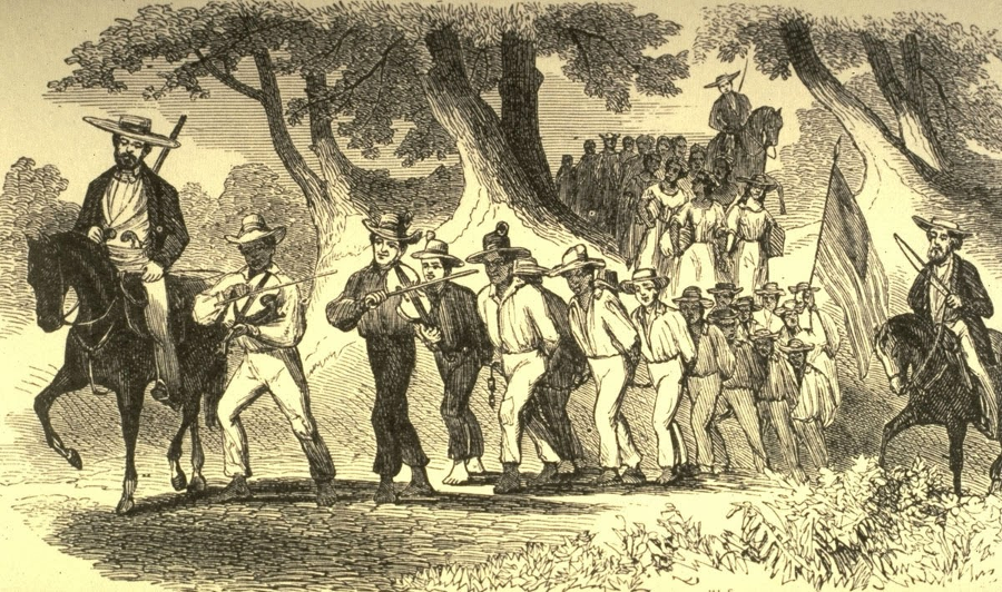
because Virginia farms were not productive, planters exported "excess" slaves to other Southern states in the first half of the 1800's
Source: A Witness to a Kentucky Slave Coffle
In ports such as Richmond the percentage of "free people of color" grew, but their economic opportunities were limited and social equality was blocked. Whites remained highly suspicious when non-whites gathered in groups. To limit the potential of any coordinated slave uprisings, new laws prohibited teaching slaves to read or write. Rural communities maintained slave patrols to ensure there would be no unauthorized gathering of slaves at night.
Fears increased after 1800, when Gabriel Prosser was accused of planning a slave uprising in Richmond. Greater restrictions were imposed on slave owners, limiting their ability to give freedom to slaves. Some people of color who married slaves ended up purchasing their spouses, technically keeping them in slavery while ensuring their protection.
The General Assembly serious considered abolishing slavery in its 1831 session, but could not resolve how to compensate slaveowners for the loss of their "property" and could not determine how to deal with freed slaves. One option was to export those freed slaves back to Africa, and Virginians were active in forming the country of Liberia. Its capital, Monrovia, is named after James Monroe.
Later in 1831, Nat Turner's Rebellion in Southampton County resulted in the death of over 50 whites and triggered more-restrictive controls over slaves in Virginia and throughout the southern states.
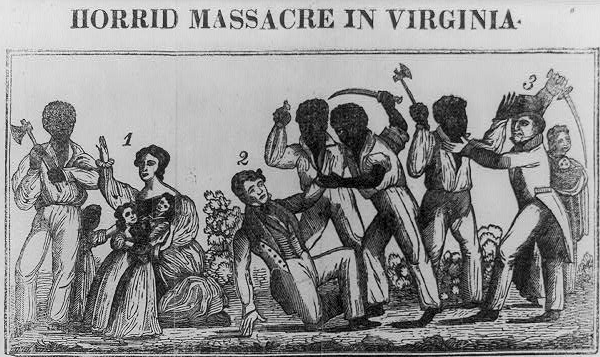
contemporary graphic of Nat Turner's Rebellion described it as a "massacre"
Source: Library of Congress, Horrid massacre in Virginia
Slavery was less popular west of the Blue Ridge. In the 1700's, Virginia expanded its cultural mix by encouraging settlement by groups of white Protestants from continental Europe.
Huguenots from France were recruited, but Virginia had even more success getting German immigrants to migrate south from Pennsylvania. Many of the Pennsylvania Deutsch (Dutch) had been Lutheran Protestants living in the Palatinate region in Europe. They fled the constant warfare between competing Catholic and Protestant rulers, immigrated to William Penn's colony where religious discrimination was minimized, but found land prices near crowded Philadelphia were high.
Walking south, crossing the Potomac River, brought the new colonial immigrants into the Shenandoah Valley of Virginia. Scotch-Irish immigrants who crossed the Atlantic Ocean and landed in Pennsylvania along with the Lutherans also moved into the Shenandoah Valley.
The further the immigrants moved south on the Great Wagon Road (modern Route 11), the cheaper the land. Both Pennsylvania Dutch and Scotch-Irish settlers were welcomed by Virginia governors such as Governor Spotswood and Governor Gooch.
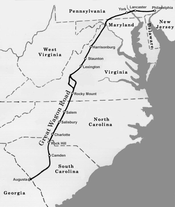
the Great Wagon Road stretched from the Potomac River to Roanoke west of the Blue Ridge, then crossed through the mountains to connect to the Piedmont of North Carolina
Source: North Carolina Museum of History, Great Wagon Road
Colonial officials saw the expanding colonial population west of the Blue Ridge as a buffer against attacks on the frontier by the French in the Ohio River Valley, and by Native Americans who had been displaced to the west. Differences in language and culture were less significant than the shared commitment to maintain English control over the western lands, whose ownership was ensured by English laws and courts based in Williamsburg.
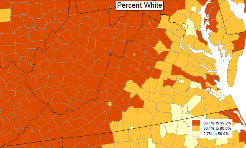
west of the Blue Ridge, all counties - and most cities - are over 80% white in racial composition
Source: Bureau of Census, Census Data Mapper (2010 Census data)
At the end of the 19th Century, mine owners in Appalachia initiated another round of recruiting workers from various places. The legal system failed to harmonize relationships between different ethnic groups, and extra-legal processes such as lynchings established the boundaries of settlement and behavior. Virginia has never been homogeneous, and has never lacked cultural conflicts.
Today, those Virginians who are related to the early English colonists are proud to identify their genealogical links to the Randolphs, the Carters, the Lees. Some have a connection even to the original residents, the very original First Families of Virginia. Numerous First Families of Virginia (FFV's) who take pride in their genealogies today can trace their ancestry back to Thomas Rolfe, son of Pocahontas and John Rolfe, and thus to Pocahontas and Powhatan and the "real" FFV's.
That connection to Pocahontas affected the implementation of de jure (legal) racial discrimination in the 1920's. Racially-biased Virginia officials tried to classify all Virginians with one drop of non-white blood as colored. Native Americans objected to being reclassified and forced to attend segregated schools with black students, and even today the discrimination of the 20th Century complicates efforts of tribes to receive Federal recognition.
Modern FFV's with a family connection to the most famous Native American from Virginia - Pocahontas - complicated those efforts to classify all Virginians with one drop of non-white blood as colored. In 1924, "An Act to Preserve Racial Integrity" established that white persons could have more than one drop of Native American blood, in order to accommodate the descendants of Pocahontas:4
Those wealthy and influential FFV's may not have celebrated cultural diversity and may not have supported desegregation, but they were proud of their one-drop connection to Pocahontas.
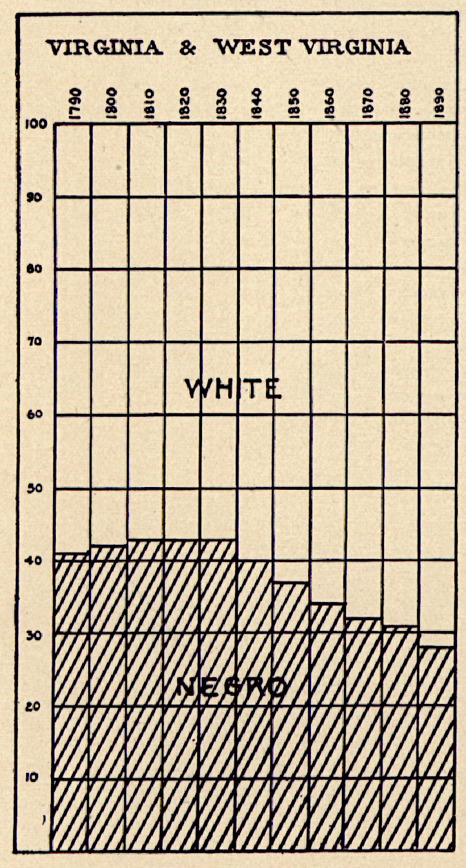
until the 1890 Census, over 30% of Virginians were "Negro"
Source: Library of Congress, Statistical atlas of the United States, based upon the results of the eleventh census (1898)
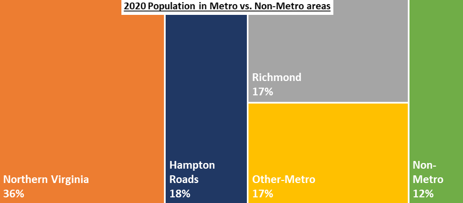
Today, Virginia's population is concentrated in three regions - Northern Virginia, Richmond area, and Hampton Roads. Most residents live in urban/suburban communities.
migration to the metropolitan areas in the 20th Century has reduced the influence of rural residents who dominated state politics under the Byrd Organization
Source: StatChat, Population Projections show that Virginia is aging and growing more slowly
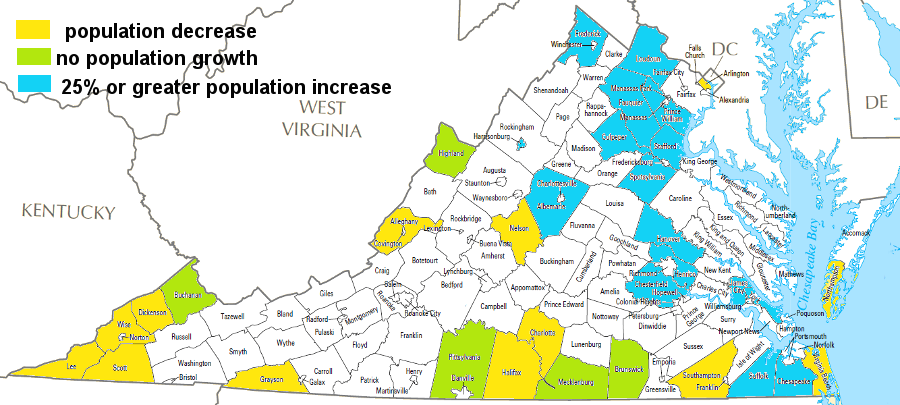
up to 2040, population is projected to decrease in several Virginia jurisdictions (yellow), stay level in others (green), and grow by more than 25% (blue) primarily in the urban crescent from DC to Hampton Roads
Source: based on projections from University of Virginia, Weldon Cooper Center, Virginia Population Projections
Map Source: US Geological Survey (USGS) National Atlas, County Map
Since World War I stimulated an expansion of the Federal government, and especially after new agencies were created and headquartered in Washington DC during the Great Depression, the population of Northern Virginia has grown dramatically.
The pattern of continuous growth in that region began to change after the COVID-19 pandemic:5
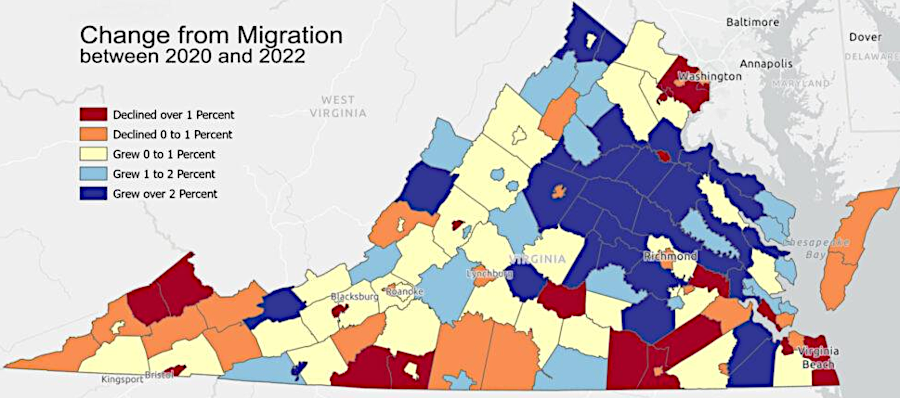
Fairfax County lost population in the years right after the COVID-19 pandemic
Source: University of Virginia, Weldon Cooper Center, After a decade of slow growth, many of Virginia’s exurbs are booming again
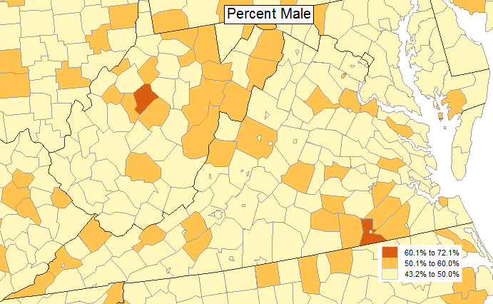
the Virginia county with the highest percentage of males in the population is also the home of the Greensville Correctional Center - Virginia's largest prison facility
Source: Bureau of Census, Census Data Mapper (2010 Census data)
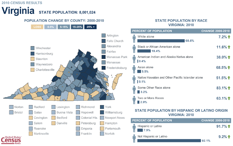
population change in Virginia, 2010
Source: Bureau of Census
![]()
the population center of the United States has steadily moved west and south since the Federal census was first conducted in 1790
Source: Bureau of Census, Mean Center of Population for the United States: 1790 to 2020
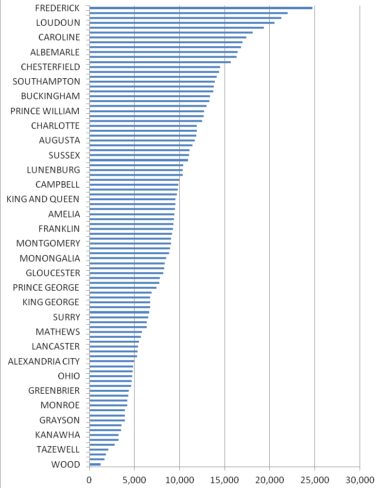
in 1800, the local jurisdiction with the largest population was Frederick County (City of Richmond was #68, Fairfax County was #20)
Source: University of Virginia Library, Historical Census Browser (1900 data)
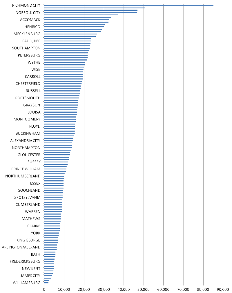
in 1900, the local jurisdiction with the largest population was the City of Richmond (Fairfax County was #35, Frederick County was #62)
Source: University of Virginia Library, Historical Census Browser (1900 data)
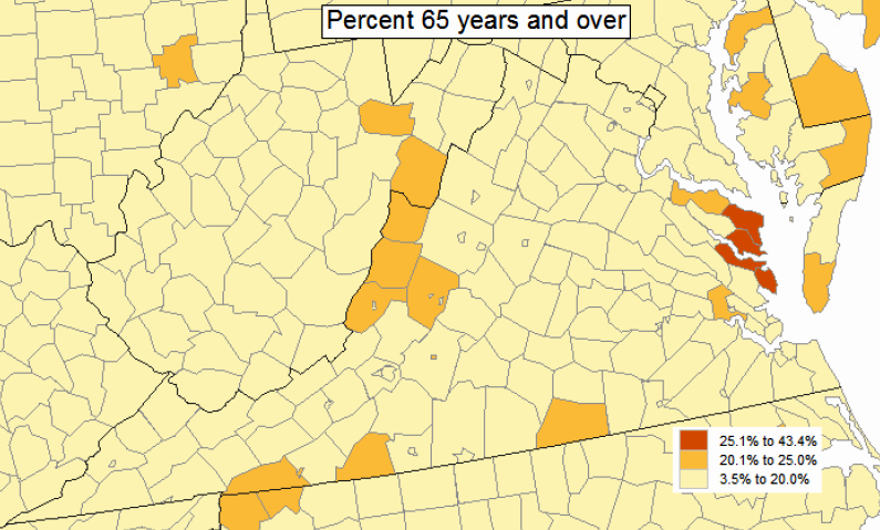
several counties next to the Chesapeake Bay - a prime location for retirees - have the largest percentage of population over 65 years old
Source: Bureau of Census, Census Data Mapper (2010 Census data)