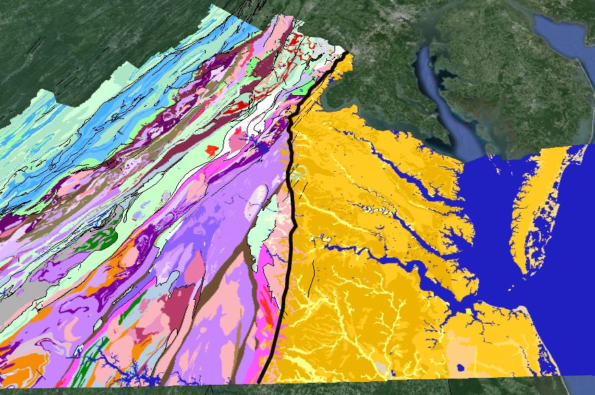
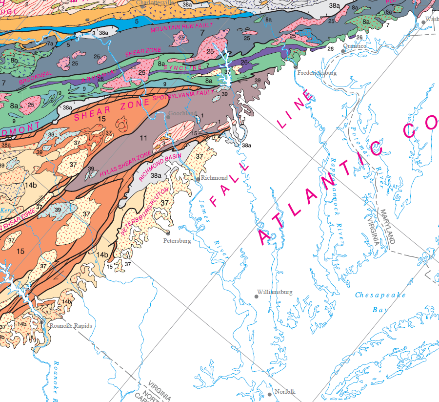
the Fall Line zone (black line) separates the Coastal Plain of eastern Virginia (yellow) from the hard bedrock of the Piedmont
Source: US Geological Survey, Virginia Geologic Map Data
the Fall Line zone (black line) separates the Coastal Plain of eastern Virginia (yellow) from the hard bedrock of the Piedmont
Source: US Geological Survey, Virginia Geologic Map Data
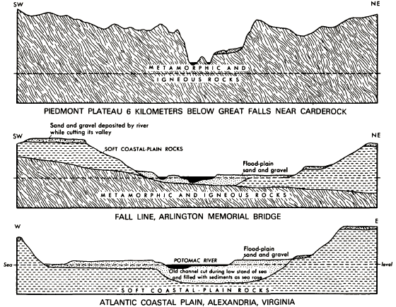
The edge of the Piedmont/Coastal Plain, where various rivers cross from hard bedrock to soft sediments, is marked by a zone of rapids and waterfalls called the Fall Line where Virginia rivers drop 50-100' in elevation. The Fall Line is closer to a zone of turbulent flow; it is not single, fixed line with a 50-100' tall waterfall at the end.
The eastern edge of the Fall Line is where rivers reach sea level. The western edge of the Fall Line can be marked as the spot where the gradient of a river gets steeper, as the channel from the Blue Ridge begins to cut through the bedrock at a faster rate.
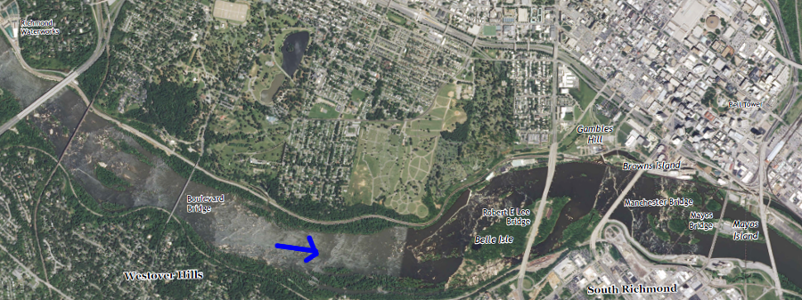
In Richmond, the zone is seven miles wide. It stretches from 100' in elevation at Bosher's Dam downstream to Mayo Island, where the water reaches sea level where 14th Street Bridge crosses the James River. Half of the elevation loss is in the last half-mile, next to Richmond's downtown. The urban rapids are popular with whitewater enthusiasts.1 /p>
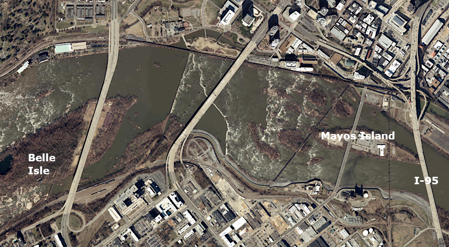
the Fall Line zone in Richmond ends at Mayo Island
Source: ESRI, ArcGIS Online
John Smith was the first European to report on this natural feature. In April, 1607, Captain Christopher Newport and John Smith led an expedition upstream from the site just chosen for Jamestown, until rapids at the current location of Richmond blocked further exploration by ship:2
Captain Newport's exploration up the James River in April, 1607 ended with the discovery of rapids near what is now called Mayo's Island in downtown Richmond (direction of flow indicated by arrow)
Source: US Geological Survey (USGS), Richmond 7.5x7.5 topographic quadrangle (Revision 1, 2013)
The Fall Line, which has been part of Virginia's landscape since the formation of the Atlantic Ocean 200 million years ago, is a geologic feature that has had great impact on the cultural geography of Virginia. That physical pattern of rapids/waterfalls blocked ships from sailing further upstream, limiting water-based transportation of the European colonists. The natural geologic barrier to shipping delayed European settlement of the Piedmont and shaped the location of major Virginia's cities, including Alexandria, Fredericksburg, Richmond, and Petersburg.
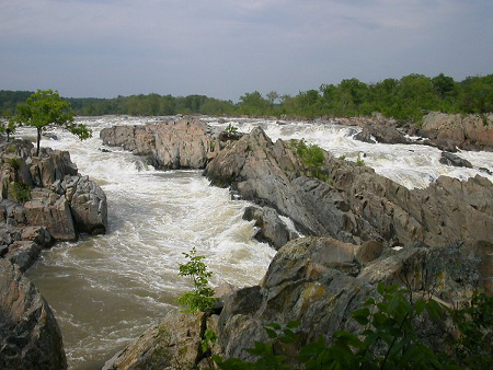
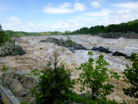
Great Falls reveals the hard metamorphic rock of the Western Piedmont/Potomac Terrane in the Piedmont physiographic province - and how rivers in flood stage carve channels
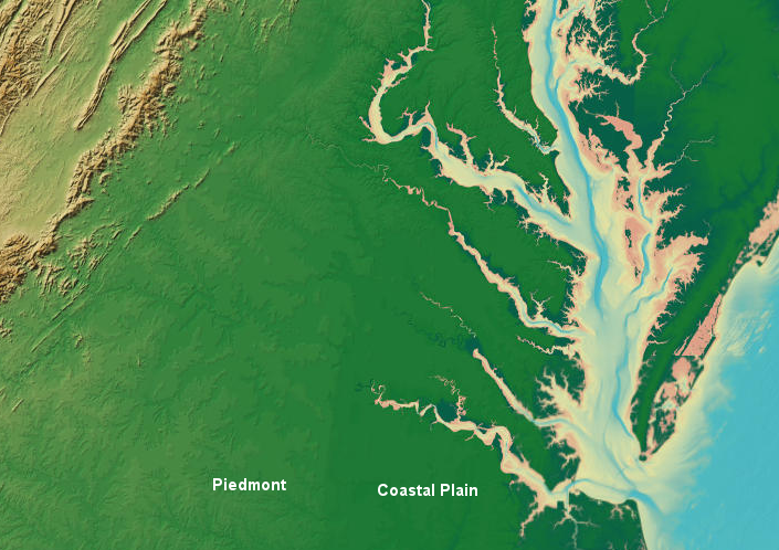
Today, Interstate 95 is a rough guide to the location of the geologic boundary that separates the soft sediments of the Coastal Plain physiographic province from the hard bedrock of the Piedmont physiographic province. East of Interstate 95, the soil of the Coastal Plain is sandy. The Coastal Plain soils are light-colored, sometimes almost yellow or even white. Topography is flat, but there are a few hills in the Coastal Plain because erosion has been uneven on the sedimentary formations. Some cliffs have been exposed where rivers have scratched out their valleys.
Fall Line (red line) separates the Coastal Plain from the Piedmont, essentially the route of modern I-95 in Virginia
Source: US Geological Survey (USGS), A Tapestry of Time and Terrain
West of Interstate 95 and Interstate 85 in the Piedmont, various plowed fields and construction sites expose reddish clay soils. Topographically, the land rises gradually in elevation towards the Blue Ridge. Virginia rivers flow eastward from the Blue Ridge and across the Piedmont to the Fall Line, then on to the Chesapeake Bay or to Albemarle/Pamlico Sound in North Carolina. Water from just one major Piedmont stream, the Ararat River in Patrick and Carroll counties, flows south though North and South Carolina and merges into the Yadkin and Pee Dee rivers before entering the Atlantic Ocean.
The Fall Line was created naturally. It reflects the different geologic histories of the Piedmont and Coastal Plain.
as Africa and North America collided, the sediments in the Iapetus Ocean were compressed and metamorphosed to become part of the bedrock in the Piedmont physiographic province
Source: Ron Blakely, "Paleogeography and Geologic Evolution of North America," Late Mississippian (325 million years ago)
Piedmont Geology - West of the Fall Line
The bedrock directly to the west of the Fall Line, the Piedmont physiographic province, was created between 250-450 million years ago in the tectonic collisions that formed Pangea. Various volcanoes, crustal fragments, and soft sediments were scrunched up from the ocean bottom and pushed onto the North American continent in a series of mountain-building events known as the Taconic, Neo-Acadian, and Alleghenian orogenies.
Chunks of silica-rich crust in island arcs similar to Japan or Indonesia, eroded sediments that accumulated next to the island arcs on the ocean floor, and basalt ocean crust were added to Virginia in those orogenies. Virginia got wider as it accreted new crust at its Iapetus Ocean coastline as the mud, sand, and soft sediments on the Iapetus Ocean's Continental Shelf were compressed, metamorphosed, and pushed onto Virginia with each orogeny. Virginia also got thinner as compression during orogenies cracked the bedrock and thrust blocks on top of other blocks, stacking the bedrock while reducing the distance they once covered.
The terranes that were squeezed onto the edge of Virginia are now exposed on the surface in the Piedmont physiographic region. Those terranes were metamorphosed about 250 million years ago as Africa bumped into the North American continent, the Iapetus Ocean disappeared, and Pangea formed. In a repeat of the formation of the Rodinia supercontinent, once again crustal fragments and Continental Shelf sediments were squeezed onto Virginia.
As the continental plates pressed together, island arcs and soft sands, shales, and muds - equivalent to what is on the bottom of today's Chesapeake Bay and Atlantic Ocean off the coast at Virginia Beach - were buried, baked, and metamorphosed. They became the hard crystalline rock now located between I-95/I-85 and the Blue Ridge. The collision formed the bedrock of today's Piedmont, the largest physiographic province in Virginia today.
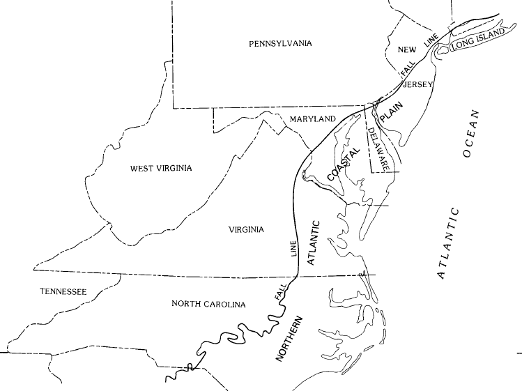
the Fall Line extends from New York to Georgia
Source: US Geological Survey (USGS), Hydrogeologic Framework Of The Virginia Coastal Plain (Professional Paper 1404-C)
About 250 million years ago, as the Iapetus Ocean disappeared and Africa merged with North America, Virginia ended up in the middle of the supercontinent known as Pangea. A tall mountain range was located where I-95 is today. It had been pushed up by the tectonic plate collisions, just as the Himalaya mountain range has been uplifted over the last 50 million years by the collision of India with Asia. The granitic roots of those mountains extended down as much as the mountains towered up above the surface, perhaps 20,000 feet.
The Fall Line developed much, much later, but its beginning was the formation of that hard Piedmont basement rock and the roots of those ancient mountains. The old continental shelf of the Iapetus Ocean and the terranes accreted onto Virginia during the Taconic and Acadian orogenies were metamorphosed, and the igneous mountain roots cooled to form additional hard bedrock. The "basement" consists of the rocks formed during the Grenville orogeny one billion years ago, the younger metamorphosed rocks formed during the Taconic, Neo-Acadian, and Alleghenian orogenies, and the igneous chunks remaining from old mountain roots and the terranes that were accreted onto the continent.
What goes up must come down. After Pangea split up, the 20,000 feet high mountains eroded away over 250 million years to expose the Piedmont's bedrock. The current Blue Ridge was once buried deeply beneath the overlying material pushed up in the Alleghenian Orogeny. The Blue Ridge has been exhumed, unburied as water and wind have carried away the overlying material.
Rivers that once flowed east-west may have reached the bedrock of the Blue Ridge perhaps 25 million years ago, near the start of the Miocene epoch. More-rapid erosion may have begun at the end of the Miocene 5 million years ago. During the Miocene, high sea levels resulted in the deposition of sediments on the Piedmont far west of the current Fall Line. Those sediments eroded after the Miocene, stripping away the unconsolidated material on top of the hard Paleozoic bedrock that had been accreted onto Virginia during the formation of Pangea. Only small remnants of Miocene gravels remain west of the Fall Line today.3
As the hard Catoctin greenstone and granitic bedrock of the Blue Ridge was exposed through erosion, it would have formed an ancient fall line. Rapids and waterfalls would have been created on rivers flowing east-west over the hard bedrock, passing through what today are "wind gaps." Some of the gaps in the Blue Ridge mark where down-cutting rivers which were flowing eastward were hindered in their ability to erode a channel. Long ago, in those modern gaps, the hard bedrock created a line of rapids and waterfalls.
Over time, other rivers west of the Blue Ridge were able to erode more quickly the material thrust up by the Alleghenian Orogeny. Through differential erosion, those other rivers diverted ("pirated") the water flowing through the mountain gaps. As other rivers etched deeper channels, water that once moved eastward across the Blue Ridge began to flow north (as in the modern Shenandoah River) or south (as in the modern Maury River), leaving gaps filled with wind rather than water.
Today the last water-filled remnants of that ancient fall line are the rapids on the Potomac River at Harpers Ferry, plus the elevation drop on the James River at Balcony Falls and at Niagara on the Roanoke River where hydropower plants have obscured the rapids.
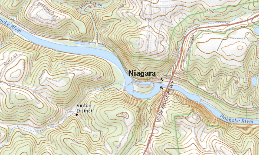
where the Roanoke River crosses the Blue Ridge at Niagara may be a remnant of an ancient fall line - until stream piracy blocked the east-west flow of most rivers
Source: US Geological Survey (USGS), Stewartsville VA 1:24,000 topographic quadrangle (2019)
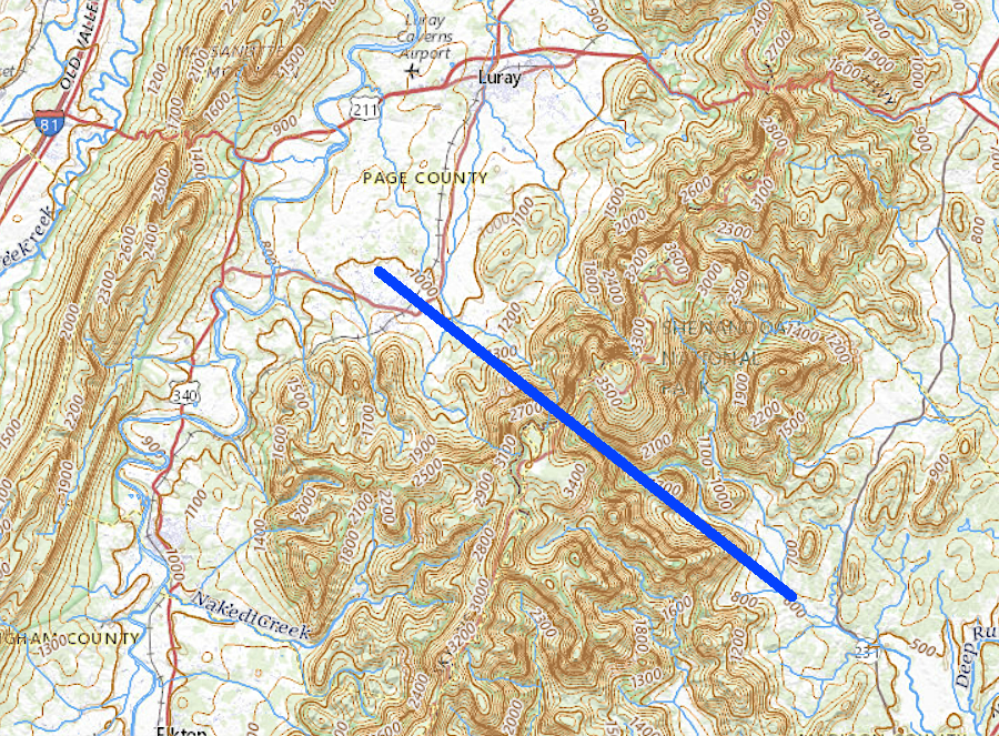
gaps in the Blue Ridge near Big Meadows, in Shenandoah National Park, may have once been rapids of an ancient river that has disappeared due to stream piracy
Source: US Geological Survey (USGS), The National Map
The metamorphic and igneous formations of the Piedmont do not stop at modern I-95/I-85. That hard crystalline bedrock is buried below the soft sediments of the Coastal Plain, and the "basement complex" continues all the way from the Blue Ridge to the edge of the Continental Shelf. Wells drilled through the coating of sediments east of the Fall Line encounter the crystalline bedrock at ever-greater depths to the east. Underneath the Eastern Shore, the basement complex is about 10,000' deep.
The last eastern exposure on the surface of the Piedmont bedrock is zone of waterfalls and rapids known as the Fall Line. When Gov. Alexander Spotswood led an expedition west across the Piedmont and across the Blue Ridge to the Shenandoah River in 1716, his party discovered that the sandy soils common near Williamsburg were rare west of the Fall Line.
The trip through the Piedmont crossed soils with hard stones which had formed as the crystalline bedrock decayed into saprolite. According to legend, Spotswood later gave mementos in the form of horseshoes to his fellow travelers and they became known as "Knights of the Golden Horseshoes," because on the trip:4
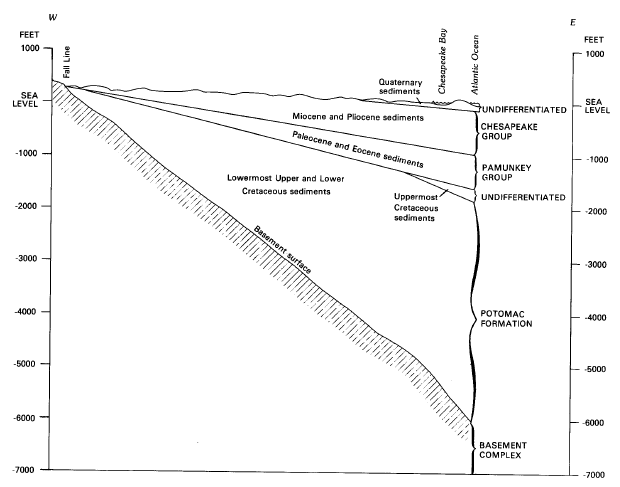
how bedrock dips underneath the Coastal Plain, between Fall Line and Atlantic Ocean
Source: US Geological Survey, Professional Paper 1404-C: Hydrogeologic Framework of the Virginia Coastal Plain (Figure 5)
Coastal Plain Geology - East of the Fall Line
East of the Fall Line, the geology story is simpler. The ground exposed at the surface, the material of concern to farms and builders, consists of sediments that are younger and softer than the Piedmont bedrock.
Much of those sediments in the Coastal Plain eroded off of the ancient Appalachian Mountains that were pushed up in the final Alleghenian orogeny. For the last 300 million years, rain and wind has etched away those mountains, carrying sand and mud westwards towards Illinois and eastward towards the Atlantic Ocean. Road cuts through West Virginia expose the layering of the oldest layers of sediments, even some dating back to erosion from the mountains that were lifted up by the Taconic and Acadian orogenies.
On the eastern side of the old Appalachians, the oldest sedimentary layers from the Taconic and Acadian orogenies disappeared when Pangea broke up and Africa moved away. The sedimentary layers still present in eastern Virginia have been deposited for the last 150 million years, and document the final stages as the ancient Appalachians once located along I-95 have eroded to a flat plain. Only their igneous roots remain, exposed in granite quarries and outcrops at Occoquan, Goochland County, Richmond, and Petersburg.
The sediments deposited by mountain erosion were carried to the Atlantic Ocean. There the river currents carrying sand, silt and clay slowed and marine sediments were deposited. All of eastern Virginia was covered with those sediments when sea level was high enough. At low stands, such as the recent Ice Age when water was locked into ice sheets and sea level was 400 feet lower, rain and wind carved into the sedimentary deposits. The sediments were carried away again, ultimately exposing the hard crystalline bedrock to create today's the Piedmont physiographic region.
The hard crystalline bedrock underneath the modern Coastal Plain is still covered by sediment deposited during the Cretaceous Period up to 145 million years ago. Some of those sediments washed off the ancient Appalachians over the last 200 million years. Others were brought by currents in the Atlantic Ocean when it covered the land up to (and occasionally beyond) the current location of I-95/I-85.
the Fall Line separates the Coastal Plain (darker green...) and the Piedmont
Source: National Oceanic and Atmospheric Administration (NOAA), National Geophysical Data Center
Two processes occurred after the last orogeny in Virginia 250 million years ago to create the Coastal Plain:
Neither process altered the sediments to convert them into hard crystalline rock, and soft unconsolidated sediments erode faster than the hard bedrock. There is a Fall Line today due to the physical differences between the hard crystalline Piedmont bedrock and the soft Coastal Plain sediments.
The sediments on the Coastal Plain have not been baked and squeezed tight; there has been no metamorphism comparable to the older bedrock exposed in the Piedmont now. There is some spots of hard rock in the Coastal Plain where ancient ocean reefs are now expsed. At other places iron was dissolved by rainwater and carried in solution down to an oxygen-free depth, where the iron came out of solution and glued sedimentary particles together. Building stones were carved from the Coastal Plain at places where the sediment was glued together, including Freestone Point at Leesylvania State Park and Government Island in Stafford County, but those building stones were far weaker than rock quarried in the Piedmont.
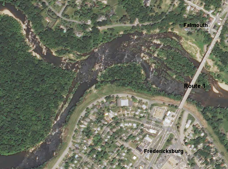
the Fall Line on the Rappahannock River led to the establishment of Fredericksburg/Falmouth and the location of Route 1
Source: US Geological Survey (USGS), Fredericksburg 7.5x7.5 topographic quadrangle (2013)
Early colonists moving west beyond the Fall Line quickly discovered locations where river currents regularly scoured the bottom of streams flowing eastward across the Piedmont. Those rivers have a thin coating of recent sediments; mud, sand and stones deposited on the river bottom since the last major flood make crossing the rivers difficult in most locations. Colonists located the fords and later built their roads to take advantage of the places where hard bedrock was exposed underwater in the Piedmont. It was far easier to cross those rivers at a ford where bedrock was exposed, compared to dragging a wagon through mud...
Such fords are very rare east of the Fall Line, except on small streams. River bottoms are soft Coastal Plain sediments east of the Fall Line; no underwater bedrock offers a hard bottom for an easy river crossing.
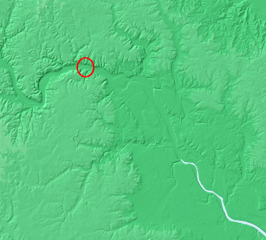
a Digital Elevation Model (DEM) shows how the Rappahannock River carved a broader valley in the soft Coastal Plain sediments, east of where I-95 crosses the river (red circle)
Source: US Geological Survey (USGS), National Map - DEM Viewer
In Tidewater, colonists avoided building a road network that crossed rivers. Instead, farmers carried tobacco and other agricultural products to wharves and docks built on the edge of the rivers. Shipping mostly by water minimized the need to get wagons across a river. When necessary, colonists such as George Mason III (father of the man who built Gunston Hall and was principal author of the Virginia Declaration of Rights) created ferry crossings to get across Coastal Plain rivers.
East of the Fall Line, the Piedmont bedrock is buried beneath young, unconsolidated sediments that hardly qualify to be labeled "rock." Rapids occur throughout the Piedmont physiographic province, from the Blue Ridge east to the Fall Line. The gradient at which a river channel drops can steepen briefly at knickpoints where rivers cross from harder to softer bedrock, reflecting ancient zones of different metamorphism or faults in the terranes. There are no such knickpoints on the Coastal Plain, and there are no rapids downstream of the Fall Line.
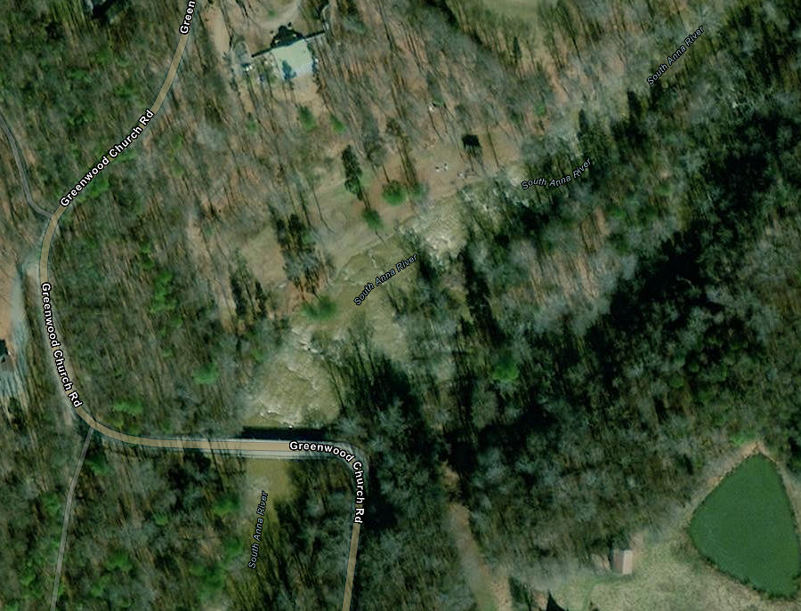
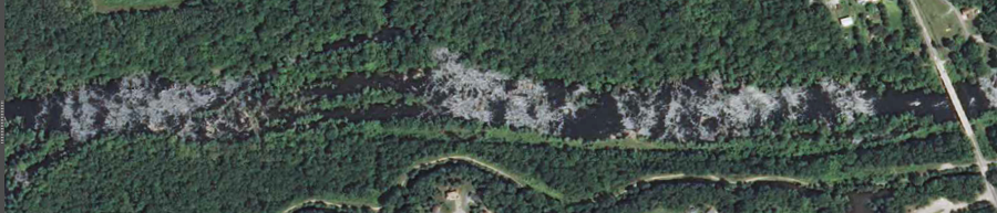
rapids occur in the middle of the Piedmont on the South Anna River northwest of Richmond, but there are no rapids on Virginia rivers downstream of the Fall Line
Source: ESRI, ArcGIS Online
When a river flowing east towards the Chesapeake Bay reaches the eastern edge of the Piedmont and encounters the easier-to-erode sediments on the Coastal Plain, the flowing water washes away those soft sediments. At the Fall Line, the energy of the river carves a deeper channel in the softer Coastal Plain sediments than in the Piedmont bedrock. The difference in the depth of the channel results in rapids and waterfalls; the water flowing off the Piedmont falls to sea level at the Fall Line.
Such rapids and waterfalls are most obvious at Great Falls on the Potomac River, on the Rappahannock River at Fredericksburg (look westward from the I-95 bridge), and on the James River near downtown Richmond (look westward from any bridge between I-95 to the Huguenot Bridge).

physiographic setting of Great Falls
Source: US Geological Survey (USGS) Bulletin 1471, The River and the Rocks: The Geologic Story of Great Falls and the Potomac River Gorge
The Fall Line waterfall on the Occoquan River near Lorton has been "dried out" by the construction of a dam, and only a trickle of water flows over the Occoquan Reservoir dam in the summer months. Fairfax Water kept the area closed to public use after acquiring the dam and reservoir complex in the 1960's, but starting in 2015 the utility agreed to open its Fall Line property upstream from the town of Occoquan to public visits. People will no longer need special permission (or have to sneak past the gates...) to see the exposed rocks at the Fall Line.
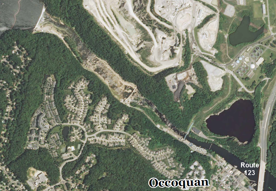
rapids at the Fall Line of the Occoquan River, below Occoquan Reservoir (Route 123 on right)
Source: US Geological Survey (USGS), Occoquan 7.5x7.5 topographic quadrangle (Revision 1, 2013)
The Fall Line zone between the Coastal Plain and the Piedmont physiographic provinces is wide. The watersheds of the tributaries upstream from the Mattaponi River are small. They carry so little water, the coating of Coastal Plain sediments has not eroded away as fast. The Matta, Po, and Ni rivers cross the geologic boundary between hard crystalline bedrock and soft sediments while still 150' or higher above sea level and without creating a set of rapids or waterfalls.
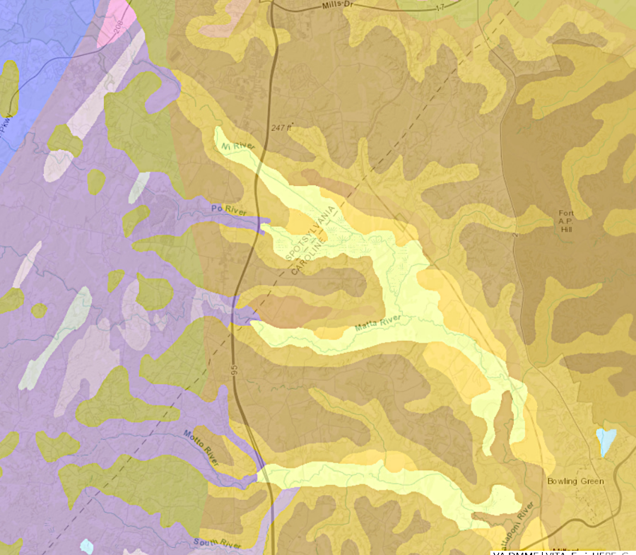
the Mat, Po, and Ni rivers carry less water and Coastal Plain sediments (yellow and brown) while still above sea level
Source: Virginia Department of Energy, Geology Mineral Resources
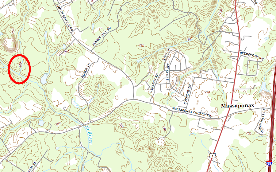
the Ni River flows onto Coastal Plain sediments while nearly 200' above sea level
Source: US Geological Survey (USGS), Spotsylvania VA 1:24,000 topographic quadrangle (2019)
the Po River flows onto Coastal Plain sediments while still 150' above sea level
Source: US Geological Survey (USGS), Spotsylvania VA 1:24,000 topographic quadrangle (2019)
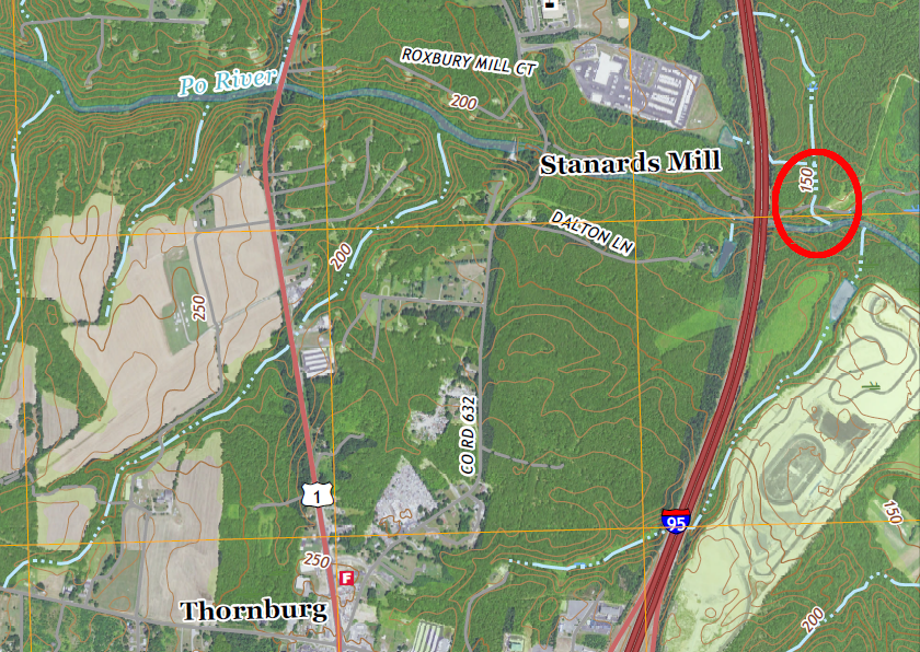
the Matta River flows onto Coastal Plain sediments while still 150' above sea level
Source: US Geological Survey (USGS), Ladysmith VA 1:24,000 topographic quadrangle (2019)

the gradual elevation changes of the Matta, Po, and Ni rivers do not reveal an obvious Fall Line
Source: ESRI, ArcGIS Online
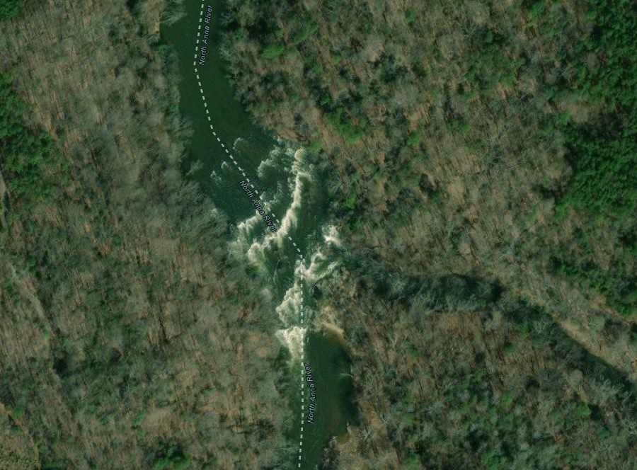
The North Anna and South Anna rivers, tributaries of the Pamunkey River, encounter sandstone and siltstone in the Taylorsville Basin when they flow east beyond the hard crystalline bedrock of the Piedmont. The metamorphosed bedrock in the Triassic Basin has a resistance to erosion intermediate between the Piedmont and Coastal Plain, so those two rivers also lack clear rapids and waterfalls.
the North Anna River flows east from hard crystalline bedrock in the Piedmont onto metamorphosed sandstone/siltstone (blue borders) in a Triassic Basin
Source: Virginia Department of Energy, Geology Mineral Resources
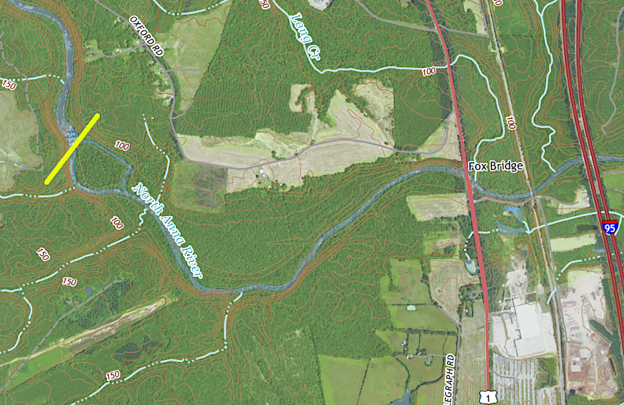
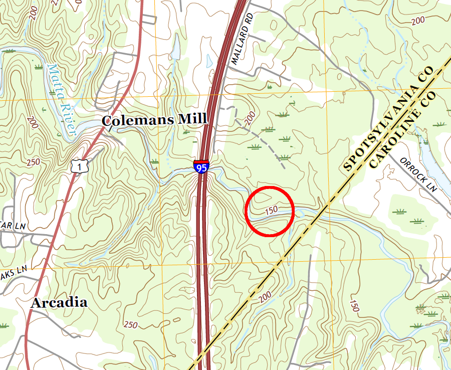
the North Anna River flows across the geologic boundary (yellow line) into a Triassic Basin while about 50' above sea level
Source: US Geological Survey (USGS), Ruther Glen VA 1:24,000 topographic quadrangle (2019)
In some places, erosion has excavated the river valleys and the actual waterfalls may be miles upstream from the geologic boundary between the Piedmont and Coastal Plain bedrock. As the rivers etch their way through the sediments at the contact between Piedmont-Coastal Plain, the harder crystalline bedrock is exposed. The waterfalls are migrating upstream, towards the west, as the sedimentary coating is eroded. At a far slower rate, the waterfalls are disappearing on the eastern edge of the Fall Zone as the bedrock is etched away to sea level.
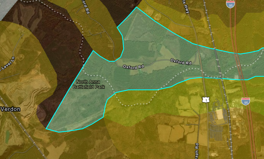
the last rapids on the North Anna River are just upstream from North Anna Battlefield Park, almost two miles west of I-95
Source: ESRI, ArcGIS Online
Today the hard crystalline rock exposed at Great Falls on the Potomac River is the bedrock in the Piedmont, while the eastern edge of that hard bedrock formation is downstream on Teddy Roosevelt Island. The contact between Coastal Plains sediments and exposed Piedmont is underneath the Teddy Roosevelt Bridge at the eastern end of I-66, where it crosses the Potomac River to connect Rosslyn with the District of Columbia at the Kennedy Center. The whitewater rapids of Great Falls are about 14 miles upstream of the geologic contact.
The Potomac River has etched its way 14 miles upstream over the last 2 million years. In the process, it has carved out Mather Gorge in the crystalline bedrock. The gradient of most Virginia rivers changes when the rivers are about 100' in elevation above sea level. Great Falls is close to the 140' contour line, because the large Potomac River has cut deeper into the bedrock. In comparison, the slow-flowing Mattaponi and Pamunkey rivers change their gradient at only the 50' elevation contour.5
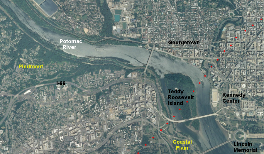
Teddy Roosevelt Island marks the geologic boundary between the hard crystalline bedrock of the Piedmont and the soft sediments of the Coastal Plain
Source: US Geological Survey (USGS), Washington West 7.5x7.5 topographic quadrangle (2014)
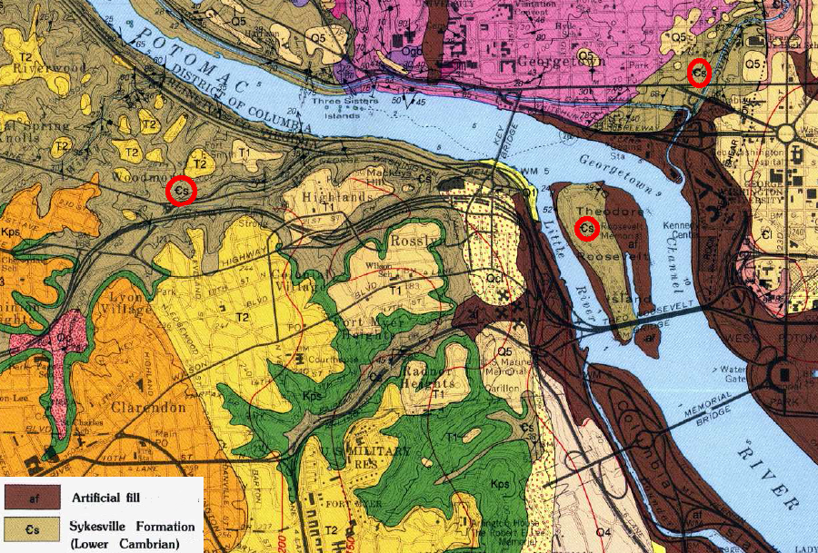
500-million-year-old (Cambrian Period) crystalline bedrock outcrops are buried beneath younger Coastal Plain sediments and artificial fill east of Teddy Roosevelt Island and Rock Creek Park
Source: US Geological Survey (USGS), Geologic map of the Washington West quadrangle, District of Columbia, Montgomery and Prince George's Counties, Maryland, and Arlington and Fairfax Counties, Virginia (1994)
Over time, the erosive power of the Potomac River will move the waterfall further upstream, past Riverbend Regional Park in Fairfax County. Great Falls will move far enough upstream to get past the Piedmont bedrock, and to etch away at the softer Triassic Basin sediments near Seneca Creek.
Because the resistance of the bedrock will be less in the Triassic Basin, Great Falls will change into a series of gentler rapids over the sandstone of the Triassic Basin. It took 2 million years to etch a channel 14 miles, an average of one mile each 150,000 years. There are about eight more miles of Piedmont bedrock before reaching the Triassic Basin. Using very simplistic math, the remaining lifespan of Great Falls is about 1-1.5 million years.
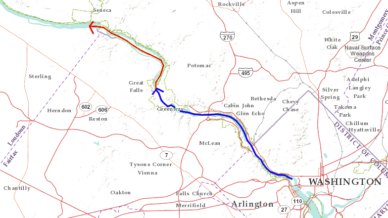
migration of Potomac River waterfall from geologic boundary at I-66 bridge upstream to Great Falls (blue), and on to Seneca Creek (red) in next million or so years
Source: ESRI, ArcGIS Online
geologic setting of Great Falls
Source: US Geological Survey (USGS), Bulletin 1471, The River and the Rocks: The Geologic Story of Great Falls and the Potomac River Gorge
The Fall Line defined by geology is in a different location that the boundary between freshwater and saltwater in Virginia's rivers. A tidal freshwater zone exists at the estuarine head-of-tide, downstream from both where rivers flow into Coastal Plain sediments and from where rivers reach sea level. Species composition in tidal freshwater swamps is changing as sea level rises and saltwater intrudes further inland. Ghost forests of trees killed by salt, with trunks still standing, are developing in wetlands that were once freshwater swamps.6
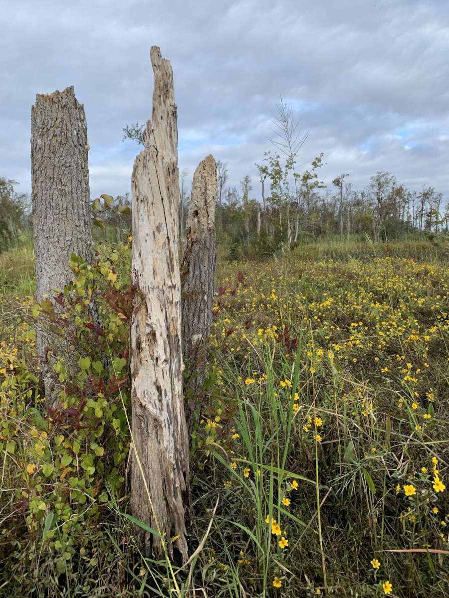
low-level salinization is forming ghost forests, replacing trees with marsh plants as saltwater intrudes westward towards the geologic Fall Line boundary
Source: US Geological Survey (USGS), A temporary boost to surviving trees in tidal freshwater swamps but steadily increasing salinity associated with sea-level rise ultimately creates "ghost forests"
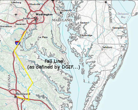
The Fall Line may be interpreted as a zone on rivers, but the Virginia Department of Wildlife Resources (DWR) requires a specific location to facilitate enforcement of different regulations for freshwater vs. anadromous/saltwater fish. The state agency prioritized the interface between freshwater and saltwater, rather than bedrock geology separating the Piedmont and the Coastal Plain.
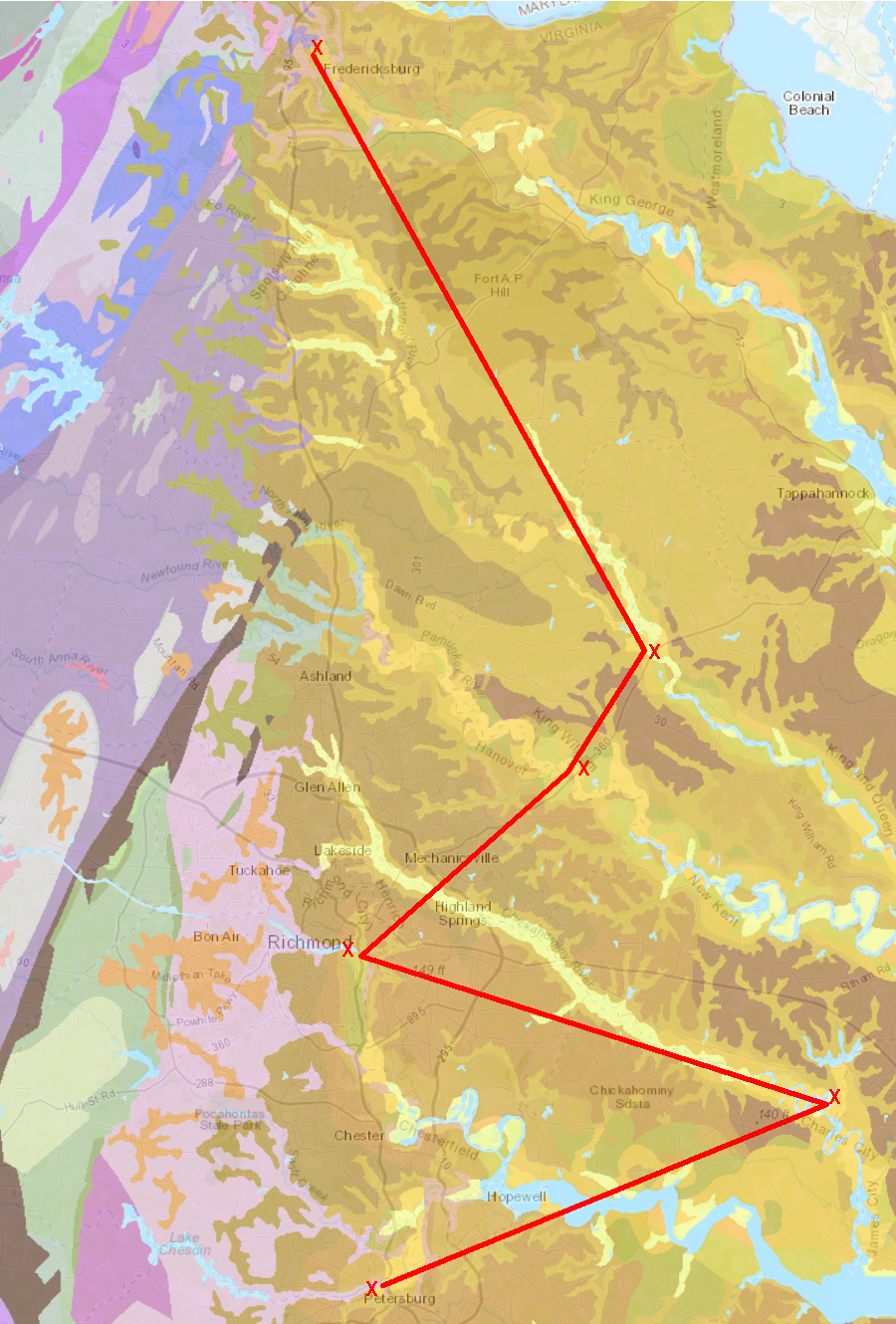
The Virginia Department of Wildlife Resources has defined a Fall Line that is based on fixed and obvious landscape features, primarily bridges that anglers and Conservation Police Officers ("game wardens") can see. The Fall Line, as defined by the Virginia Department of Wildlife Resources for regulatory purposes, is at the 14th Street bridge over the James River in Richmond. It then zigs eastward to Walkers Dam on the Chickahominy River, then back to the Route 360 bridges over the Pamunkey and Mattaponi rivers. The regulatory boundary then moves westward again to the Route 1 bridge at Fredericksburg and the Interstate 95 bridge over the Occoquan River.
Such a zig-zag line does not match the changes in geology or topography, but do approximate boundaries between waters preferred by saltwater and freshwater fish. The following landmarks are used by the Virginia Department of Wildlife Resources to define its version of the Fall Line:7
Fall Line, as defined by Virginia Department of Wildlife Resources
Map Source: US Geological Survey, National Map
There are multiple ways to define the Fall Line as a feature on the landscape, based on different perspectives.
From a geological perspective, the Fall Line might be the contact between sedimentary and metamorphic bedrock. From a historical perspective, the Fall Line might be the spot in the rivers where colonial shipping was blocked. From a cultural perspective, the Fall Line might be the pattern of cities stretching from Philadelphia to Augusta which developed near the barrier for shipping, and where waterpower was available.
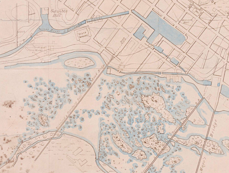
the James River and Kanawha Canal through Richmond bypassed the rapids at the Fall Line
Source: National Archives, Map of City of Richmond, Virginia (1858)
From a river-based perspective, the Fall Line might be a zone several miles wide through which rivers drop as much as 100 feet in elevation. From a wildlife management perspective, the Fall Line might be drawn in a location that simplifies enforcement of fishing regulations.
Determining what is the "right location" of the Fall Line depends on the point of view, and the purpose for making a definition.
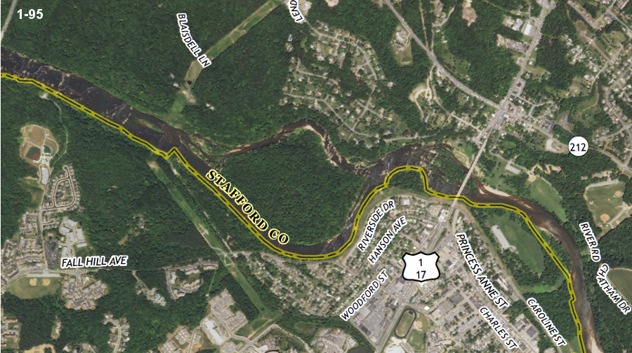
rapids at the Fall Line of the Rappahannock River in Fredericksburg (I-95 just to left)
Source: US Geological Survey (USGS), Frdericksburg 7.5x7.5 topographic quadrangle (Revision 1, 2013)
rapids at the Fall Line of the Appomattox River at Petersburg (west of I-95)
Source: US Geological Survey (USGS), Petersburg 7.5x7.5 topographic quadrangle (Revision 1, 2013)
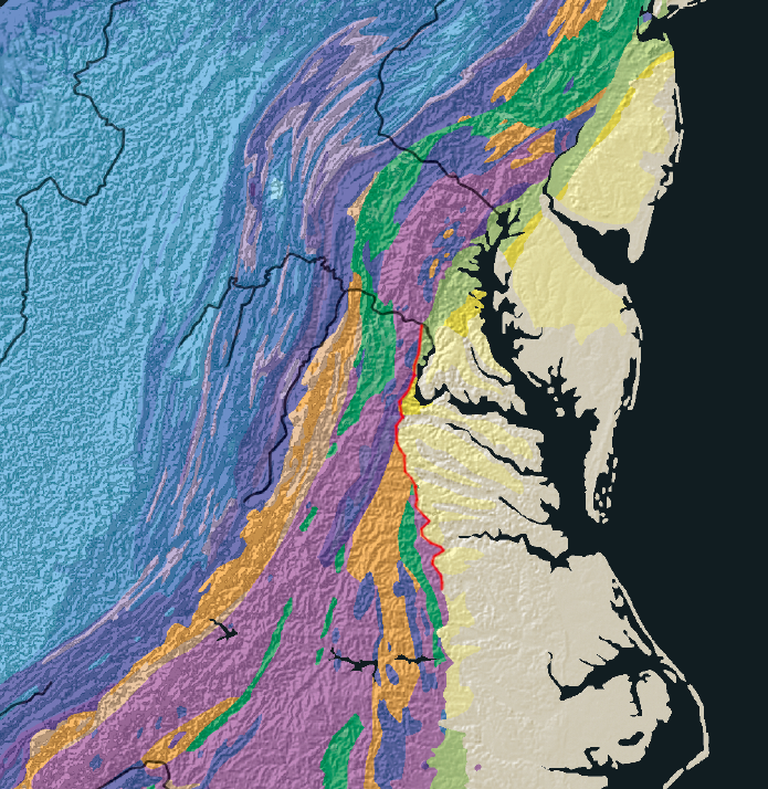
the Fall Zone in Virginia extends from Arlington County to Greensville County
Source: Geological Survey of Canada, Lithotectonic map of the Appalachian Orogen, Canada-United States of America (2006)
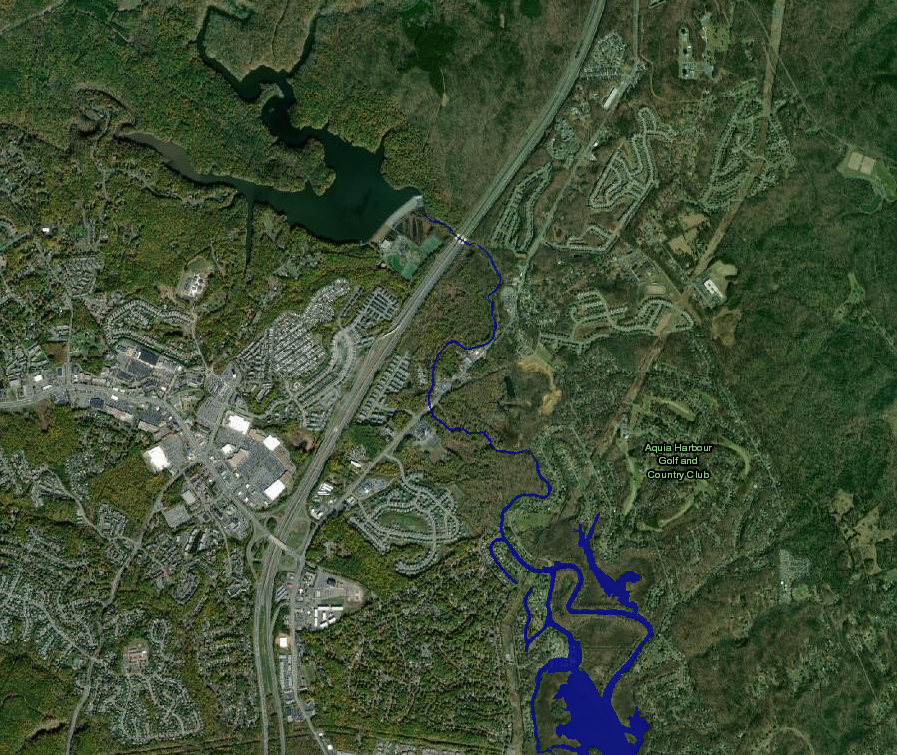
a dam on Aquia Creek at the Fall Line forms Smith Lake in Stafford County
Source: National Oceanic and Atmospheric Administration (NOAA), Sea Level Rise Viewer

no hydropower facilities in Virginia are located on the Coastal Plain - all rely upon the topographic relief at the Fall Line, or further west
Source: Energy Information Administration, State Profile and Energy Estimates - Virginia
Fall Line divides the Coastal Plain and Piedmont physiographic provinces
Source: US Geological Survey Design, Revisions, and Considerations for Continued Use of a Ground-Water-Flow Model of the Coastal Plain Aquifer System in Virginia, Water Resources Investigations Report 98-4085
the Virginia Department of Wildlife Resources defined a Fall Line for fishing regulations that does not line up with bedrock geology
Map Source: Virginia Department of Energy, Geology Mineral Resources