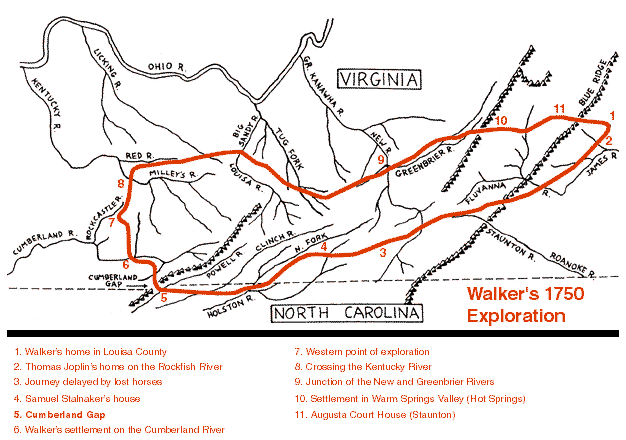
route of Dr. Thomas Walker through Cumberland Gap, 1750
Source: National Park Service - Cumberland Gap National Historical Park, Dr. Thomas Walker
route of Dr. Thomas Walker through Cumberland Gap, 1750
Source: National Park Service - Cumberland Gap National Historical Park, Dr. Thomas Walker
Thomas Walker was one of the early Virginia explorers who pushed westward across the Appalachian Mountains, expanding European settlements by documenting the existence of Cumberland Gap, building the first colonial house in Kentucky, and surveying both parcels for sale and boundaries between colonies.1
He was born in Tidewater (King and Queen County) and educated at William and Mary in Williamsburg. He worked as a doctor in Fredericksburg and operated a business in Louisa County. After he married a rich widow, they moved to Albemarle County, from which he was elected to the House of Burgesses. He was successful in developing relationships there, and became a member of the Loyal Land Company which obtained an 800,000 acre land grant in 1849.2
To survey and sell that land, Walker became one of the great explorers of southwestern Virginia. He was the first European to document crossing Cumberland Gap, which he called Cave Gap, and "discover" Kentucky. He was not the first person ever to cross the gap - Native Americans had lived in the area for perhaps 10,000 years - and as Walker recorded in his journal on April 17, 1750, he was not even the first European to cross it and mark the passage:3
To clear title to the land claimed by the Loyal Land Company, Walker negotiated with the Iroquois at the Treaty of Fort Stanwix in 1768, and with the Cherokee for the Treaty of Lochaber in 1770. He led the 1779-80 survey of the Virginia-North Carolina border, marking the Walker Line (in an incorrect location...) all the way to the Tennessee River.
In 1864, after his explorations of southwestern Virginia and the Cumberland Plateau but before his service as a treaty negotiator, Walker built Castle Hill on the 15,000 acres in Albemarle County that came with his marriage to Mildred Thornton Meriwether. That plantation home was on the route taken by Banastre Tarleton in 1781, in his effort to surprise the Virginia legislators assembled in Charlottesville. Legend records that Walker insisted on being hospitable to the visiting British cavalry, delaying them long enough for Jack Jouett to get to Charlottesville first and for Thomas Jefferson to flee.4
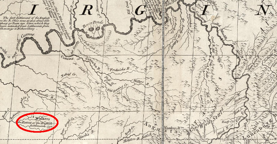
Thomas Walker's 1750 house was documented as the furthest extent of English settlement on John Mitchell's 1755 map
Source: David Rumsey Map Collection, Map of the British and French Dominions in North America
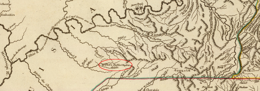
French maps in 1755 also showed Thomas Walker's 1750 house
Source: David Rumsey Map Collection, Cours de l'Ohio, Nlle. Angleterre, Nlle. York, Pensylvanie, Virginie, Caroline (by Robert de Vaugondy, 1755)