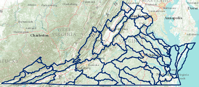
hydrologic units in Virginia
Source: Virginia Department of Conservation and Recreation, Virginia Hydrologic Unit Explorer
hydrologic units in Virginia
Source: Virginia Department of Conservation and Recreation, Virginia Hydrologic Unit Explorer
When people use water, it's not "pure" anymore - but how clean was it before it came into the house?
Rainwater can be too acidic for some circumstances. When the Rappahannock, Shenandoah and Warren Regional Jail Authority built a new jail in 2014, it installed a system to collect and use rainwater in the cooling tower. The rainwater threatened to corrode the metal in the cooling system, which was designed to use "standard" water from a drinking water utility. The jail system was modified to add a neutralizer, raising the pH.1
When rainwater reaches the ground, it dissolves material; Virginia's surface waters are not naturally pure. Some erosion of sediments into streams is natural, and nutrients are contributed to Virginia's waters by wildlife. Unlike humans, deer, ducks, and fish don't have bathrooms attached to sewers and wastewater treatment plants. E. coli and other coliform bacteria commonly found in the intestines of warm-blooded mammals were present in Virginia's waters before the first humans arrived perhaps 15,000 years ago.
Wildlife (deer, geese, mice, snakes, etc.) excrete wastes, but Mother Nature and Father Time can handle the natural levels of pollution. Exposure to sunlight or oxygen as water runs down natural streams will kill harmful bacteria and viruses.
Fortunately, wildlife is rarely concentrated enough to create sufficient waste that affects water quality - predators ensure the critters stay separated from each other. However, urbanizing counties in Northern Virginia and Tidewater are removing massive amounts of natural habitat, concentrating critters unnaturally in the few remaining forested strips along stream channels. Occasionally, DNA tests of water samples that come back with high levels of fecal coliform show the source of the bacterial contamination was geese, raccoons, or other wildlife that had no other place to live or "to go" besides next to the stream.
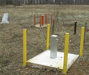
wild rice in Quantico Creek estuary and test well for contaminants at Occoquan Bay National Wildlife Refuge
Some phosphorous, nitrogen, and other chemicals occur naturally in Virginia waters. Those chemicals dissolved into solution as the rainwater percolates through the soil and as the groundwater interacts with the bedrock and soil. In karst environments, water is typically "hard" (high in dissolved calcium ions) due to the natural process of limestone being affected by acidic groundwater, which etches away at the bedrock and occasionally forms caves.
In southeast Virginia, the natural decaying organic matter in the Dismal Swamp may interact with the chlorine used in drinking water purification plants. That interaction can create a high level of trihalomethanes, a chemical that could create serious health effects. Residents of the City of Chesapeake claimed that miscarriages were caused by high levels of trihalomethanes in the drinking water from the Northwest River Water Treatment Plant.
Some chemicals have been introduced into the environment, or concentrated far beyond natural "background" levels. For example, rainwater that washes off a lawn, golf course, or soccer field that has just been fertilized will carry nitrates into the local streams and lakes. If someone dumps old motor oil onto a driveway, after changing the oil in their car, then that pollution will seep into the ground and contaminate the water. Plumes of gasoline and heating oil pollution have been mapped, showing the spread of the chemical from leaking underground storage tanks.
When we put fertilizer on our lawn, golf course, or farm fields, we add valuable nutrients to the soil for plants to use in growing. Fertilizers with N-P-K and 10-2-2 on the bad are advertising the relative percentages of nitrogen, phosphorous, and potassium.
However, too much of a good thing can create a problem. If a rainstorm washes the fertilizer that we just spread on the lawn out into the gutter/ditch, those nutrients have been wasted and will end up growing weeds in a ditch, or flow all the way to a stream and change its chemistry rather than help you grow grass or crops. Contaminated rainwater can also seep underground, especially in karst topography with caves and sinkholes, sending a plume of pollution into the groundwater.
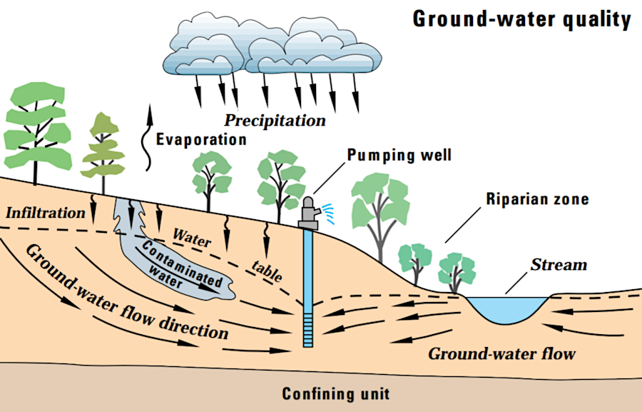
plumes of pollution from the surface can contaminate groundwater used for drinking/irrigation
Source: US Geological Survey (USGS), Pesticides in groundwater can eventually contaminate well water
Nearly all wastewater treatment plants in Virginia were built after World War Two. Prior to treatment, sewers simply carried human waste directly to rivers, and the solution to pollution was dilution. The people living next to the sewage pipe may not have thought that was an effective solution, and ultimately government agencies acted to clean up wastewater.
Clean is, like pollution, a human-centered term. When humans use water, we alter its qualities by adding chemicals, nutrients, salts, etc. Today, the basis for adequate treatment for water to be clean enough is established by the Federal government, but enforced by the State of Virginia (primarily the Department of Environmental Quality).
To address surface water pollution, the US Congress passed the Clean Water Act in 1972, after recognizing that the Federal Water Pollution Control Amendments of 1948 were not sufficient. The basic goal was for all waters to be suitable for swimming and fishing.
Based on the Clean Water Act and later amendments, the Environmental Protection Agency (EPA) has established detailed Federal water quality standards. The Federal agency delegated primary responsibility for enforcement of those water quality standards to most states, including Virginia. States can impose additional standards to manage pollution, but may not allow lower water quality standards - so state/local governments can not try to recruit businesses by offering greater freedom for factories to pollute.
DEQ monitors for over 130 pollutants. Temperature is also a factor; cooling water coming into a natural stream from a power plant is typically warmer than natural. Wastewater treatment plants process the water, but do not clean up 100% of all the pollutants.
DEQ issues permits to allow wastewater, at a defined minimum level of quality, to go into creeks at defined locations such as the outlet pipe coming from a school or factory. In the jargon of pollution control, these "point sources" of pollution are managed through pollution limits defined in individual National Pollution Discharge Elimination System (NPDES) permits established under Section 402 of the Clean Water Act.
When states are not aggressive enough in enforcing the Clean Water Act, citizens can file suit to force compliance with the Federal law. Such lawsuits have forced Virginia to accelerate the assessment of water quality, to see which waterbodies are clean enough to meet the uses defined for it. EPA must approve the water assessments completed by the state, plus clean-up plans known as Total Maximum Daily Load (TMDL) plans.
Fish kills in Shenandoah and James River started in 2004. Development of "intersex" smallmouth bass with both male/female characteristics suggest that pesticides/herbicides and hormones (including estrogen excreted by humans using birth control pills) are altering natural patterns.
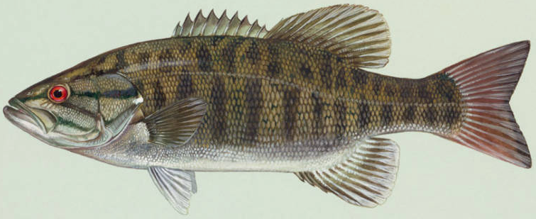
smallmouth bass
Source: US Fish and Wildlife Service, Duane Raver artwork
TMDL plans developed by DEQ define how much pollution can be absorbed each day by a particular waterbody (creek, lake, or estuary such as the Chesapeake Bay). Since the 1998 consent decree, all TMDL's were scheduled for completion within 12 years after impairment is identified.
Despite commitments to "Save the Bay" since 1983, the states missed the 2010 deadline to complete a Chesapeake Bay TMDL. A Federal judge acted in response to a lawsuit by citizen groups, and EPA completed the TMDL as a Federal document. the Chesapeake Bay TMDL established a timeline for reducing the excessive amounts of sediments, nitrogen, and phosphorous flowing into the bay from the six watershed states (NY, WV, PA, DE, MD, VA) and the District of Columbia. Each state has prepared a Watershed Implementation Plan (WIP), with a schedule of corrective actions that will be completed by the year 2025.
Virginia DEQ has assessed streams, lakes, and estuaries in nearly all of its 1,247 separate hydrologic units or subwatersheds. Each of the 1,247 separate hydrologic units is identified by a 12-digit hydrologic unit code in the National Watershed Boundary Dataset, and averages between 10-40,000 acres. By 2012, only 14 of the watersheds had not been evaluated yet.3
Status of Virginia Water Bodies, 2012
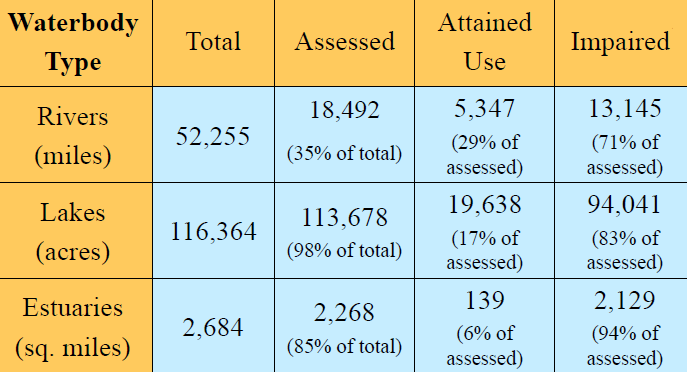
Assessment Results for Virginia Water Bodies, 2012
Source: Virginia Department of Environmental Quality (DEQ), summary presentation -
2012 Draft Water Quality Assessment and Impaired Waters Integrated Report (March 12, 2012)
DEQ documents which water bodies (sections of a stream, lake, or estuary) meet standards for at least one designated use in the bi-annual 305(b)/303(d) Water Quality Assessment Integrated Report. If a stream segment, reservoir, or estuary is designated as "impaired," then the state must conduct a TMDL study to determine which pollutants are excessive and must be reduced in order to meet Federal standards.
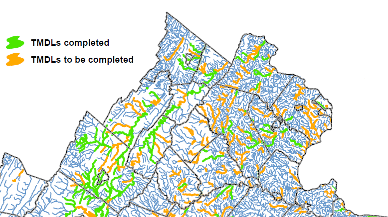
TMDL's to be completed in Northern Virginia, as of December 2011
Source: Virginia DEQ, TMDL Completion Status in Virginia Waters
According to the Clean Water Act, streams/lakes/estuaries with water quality measured below the minimum Federal standards require corrective action. A clean-up of a waterbody starts with the determination of what pollutant(s) exceed the level which can be assimilated naturally. EPA defines five categories for classifying streams, based on water quality assessments:
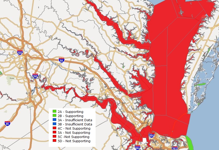
"impaired waters" by category in Tidewater Virginia, 2010
Source: DEQ, Virginia Environmental Geographic Information Systems
A waterbody can assimilate some pollution and still meet Clean Water Act standards. According to EPA's Toxics Release Inventory, in 2012 the New River was the "third most contaminated waterway in the United States," primarily due to nitrates released by the Radford Army Ammunition Plant. That facility is one of the few that produce propellants for military artillery, cannon, and mortar projectiles. The site was chosen in 1940, in preparation for World War Two. The location offered access to water and raw materials (including cellulose), plus rail transportation, while being far from the Atlantic Ocean and potential enemy attack.
The Radford Army Ammunition Plant has reduced its release of nitrates, but the volume of pollution alone does not determine if a water body is polluted or clean. As noted by DEQ, the New River is designated impaired not because of nitrates, but because the river has excessive levels of polychlorinated biphenyls (PCB's) in fish tissue. The nitrates do not trigger a classification as impaired:4
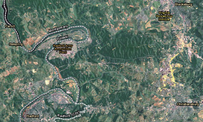
nitrate pollution in New River is high, but does not impair the river -
or affect the Chesapeake Bay, since the river is on the western side of the Eastern Continental Divide
Map Source: US Fish and Wildlife Service, Wetlands Mapper
Separate TMDL's must be completed for each pollutant in a waterbody. Not everything undesirable in a river is defined as a pollutant. Starting in 2010, the Shenandoah riverkeeper tried to get the Virginia Department of Environmental Quality (DEQ) to designate the river as "impaired" due to excessive algae growth. Massive algae blooms replaced aquatic grasses, reducing water clarity and causing occasional odor issues. However, since DEQ had failed to establish a standard for acceptable vs excessive algae, the state refused to define the Shenandoah River as impaired.5
Based on existing water quality standards, Virginia could end up with more TMDL's than the 1,247 water bodies defined by DEQ, since a different TMDL could be prepared for each pollutant exceeding a specific standard. DEQ could create a massive pile of documentation, analysis, and recommended actions. However, completing a TMDL, putting the report on a shelf, and then taking no follow-up action does nothing to clean up water in the real world.
As described by Virginia Cooperative Extension, a TMDL Implementation Plan is the document that determines who will have to take action in order to reduce the source of the pollution:6
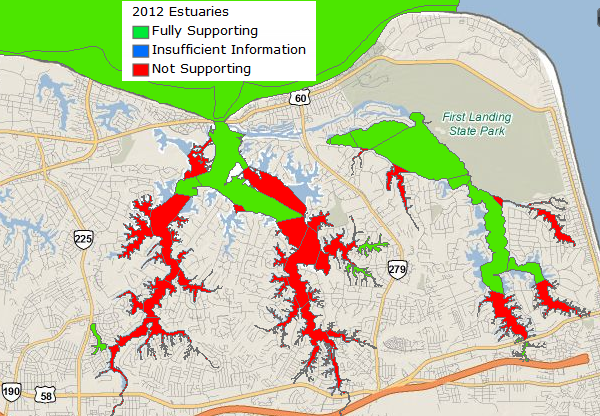
Virginia Department of Environmental Quality (DEQ) determines if water quality in Lynnhaven River meets the intended use and supports shellfish on a regular basis
Source: Virginia Environmental Geographic Information System, 2012 Draft Impaired Waters (303D Data) Database GIS Applications
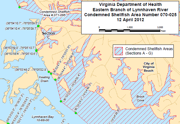
a separate agency, the Virginia Department of Health (VDH), issues orders "condemning" shellfish beds in specific areas and blocking harvest, often after storms carry pollution off nearby land
Source: Virginia Department of Health (VDH), Notice And Description Of Shellfish Area Condemnation Number 070-025, Eastern Branch Of Lynnhaven River (Effective 12 April 2012)
There is a way to meet EPA's requirements without cleaning up a stream completely. Virginia can change designate uses for a stream. Such a change can alter the requirements (and costs) for clean-up.
After completing a Total Maximum Daily Load (TMDL) clean-up plan and Use Attainability Analysis for surface water bodies that do not meet water quality standards, the State Water Control Board could redefine the intended use and lower the standard (and the costs) to make waters "clean."
Maryland, Virginia, and EPA completed a Use Attainability Analysis and redefined the designated uses for the Chesapeake Bay and its tidal tributaries in 2003. The old standard required 5 mg/L dissolved oxygen year-round throughout all tide-influenced waters, but the "one size fits all" standard did not fully reflect natural conditions. The government agencies decreased the required water quality in the deepwater channels of the bay, allowing a lower level of dissolved oxygen, and increased standards in other areas of the bay.7
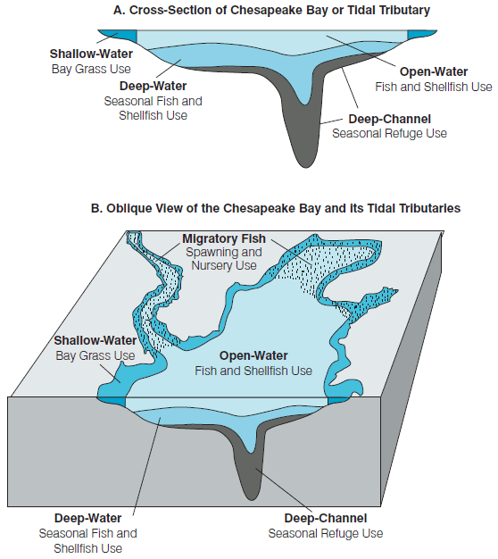
Conceptual illustration of the five Chesapeake Bay tidal water designated use zones
Source: EPA, "Ambient Water Quality Criteria for Dissolved Oxygen, Water Clarity and
Chlorophyll a for the Chesapeake Bay and Its Tidal Tributaries" (April, 2003)Figure 1.
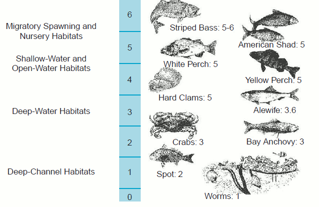
Dissolved oxygen (mg liter-1) concentrations required by different Chesapeake Bay species and communities
Source: EPA, "Ambient Water Quality Criteria for Dissolved Oxygen, Water Clarity and
Chlorophyll a for the Chesapeake Bay and Its Tidal Tributaries" (April, 2003)Figure 2.
An even bolder alteration in standards through a Use Attainability Analysis has been proposed on the other side of Virginia. Straight Creek is a tributary of Powell River that flows for six miles through St. Charles in Lee County, and has been heavily impacted by discharges from coal mines. The unregulated sewage discharges and failing septic systems on Straight Creek will be corrected to reduce excessive bacteria. However, flood control projects created an unnatural channel, with houses built on the original flood plain and minimal tree canopy developed over the relocated stream - and surges of pollution from upstream mining have killed fish in the creek several times.
The mining industry in Southwestern Virginia recognized that correcting the Total Dissolved Solids (TDS) problems and restore a balanced, indigenous population of aquatic life in Straight Creek was a major challenge - and that there were options. In 2007, the VA Coalfields TMDL Group (also known as the Virginia Mining Issues Group) asked DEQ and the State Water Control Board to approve an Aquatic Life Use Attainability Analysis (UAA). The local group sought to reduce the standard for water quality to eliminate the cost for restoring the creek to support any aquatic life (such as dragonflies).8
The industry group asked "Do we really want to force people to relocate so that we can establish a 'natural' stream design? Many of the residences were constructed more than 75 years ago." Changing the stream so the water included lower levels of mining waste (dissolved solids) and creating a more-natural habitat to restore aquatic life "would be a serious financial burden."9
Water "pollution" is a human-centered term, and the standard for Straight Creek may end up being set at a lower level than the standard for most other Virginia streams. While the aquatic life standard for the Chesapeake Bay was adjusted for different parts of the bay, to support different forms of life (with worms and clams in the deep-channel requiring the lowest amount of dissolved oxygen), the requirement to ensure any form of aquatic life may be dropped completely for Straight Creek.
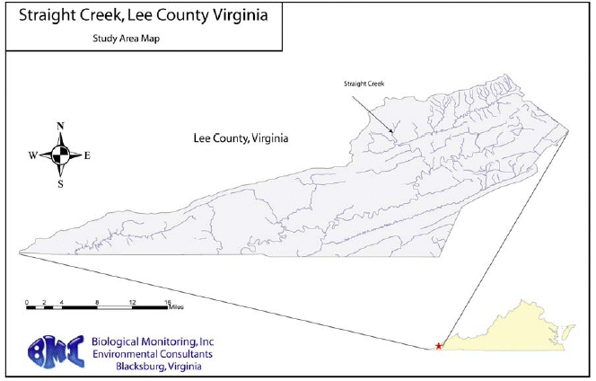
Source: Study Plan: Straight Creek Use Attainability Analysis
Most pollution is triggered by human-caused impacts. When we strip the vegetation and expose raw soil, rain washes sediment into streams. When our cattle deposit manure on farm pastures (and suburban residents mimic that process by applying fertilizer to lawns), excessive nitrogen and phosphorous moves downhill into our waterways. When ocean-going freighters discharge ballast water in the Chesapeake Bay, we introduce non-native (and sometimes invasive) species.
When we hit the brake pedal, the brake pads and tires deposit heavy metals on roadways. Even when cars sit idle, they ooze grease and other petroleum products that migrate into our lakes and creeks.
After we burn coal to generate electricity, sulfur escaping up the smokestack creates acid rain. Industrial operations have released excessive amounts of mercury directly into the South River at Waynesboro, and the North Folk of the Holston River at Saltville. Mercury vaporized by coal combustion is redeposited across the land and washed by rain into streams, poisoning every waterbody in Virginia and even the furthest reaches of the oceans. Bacteria transform the non-toxic form of elemental mercury into methylmercury, which bioaccumulates in fish and can cause nerve damage/mental retardation in humans.10
In developed areas, wastewater treatment plants minimize but do not eliminate contamination from sewage. The basic problem is population growth, with incremental impacts from every new resident. As more people that move into a watershed, the waters experience greater impacts. As the population continues to increase in Virginia, the environmental impacts will grow and grow even if each resident adopts a "greener than average" lifestyle.
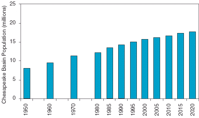
population growth in the Chesapeake Bay, doubling since 1950
Source: Technical Support Document for Identification of Chesapeake Bay Designated Uses and Attainability (Figure II-5)
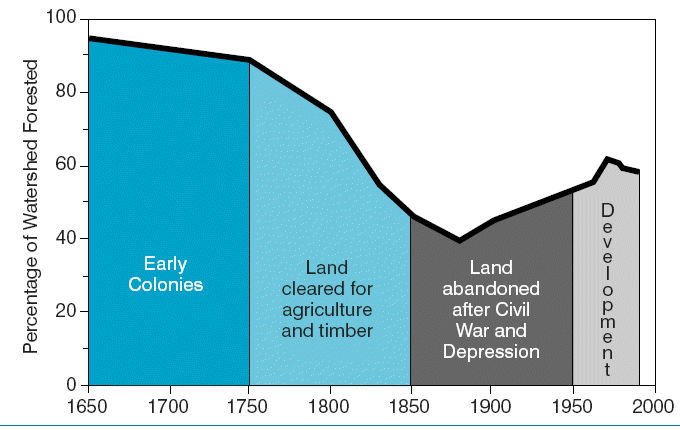
Trends in Chesapeake Bay basin forests expressed as percentage of the
watershed that was forested since 1650
Source: Technical Support Document for Identification of Chesapeake Bay Designated Uses and Attainability (Figure II-8)

when assessed for water quality, over 2/3 of the waters in Virginia are not safe for fishing/swimming
Source: Environmental Integrity Project, The Clean Water Act at 50
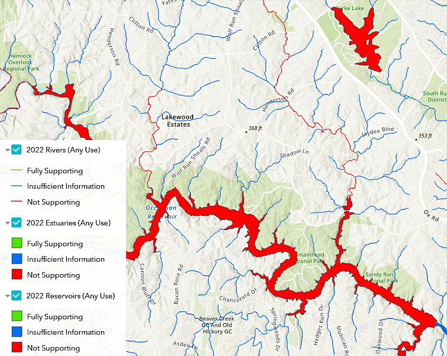
the Final 2022 305(b)/303(d) Water Quality Assessment Integrated Report showed Burke Lake and the Occoquan Reservoir as impaired
Source: Virginia Departmnt of Environmental Quality (DEQ), Environmental Data Mapper
Contrary Creek remains highly acidic, polluted by pyrite mining in the 19th and 20th centuries (Louisa County)