all thermal springs in Virginia are located in the Valley and Ridge physiographic province
Source: NOAA National Geophysical Data Center, Thermal Springs
all thermal springs in Virginia are located in the Valley and Ridge physiographic province
Source: NOAA National Geophysical Data Center, Thermal Springs
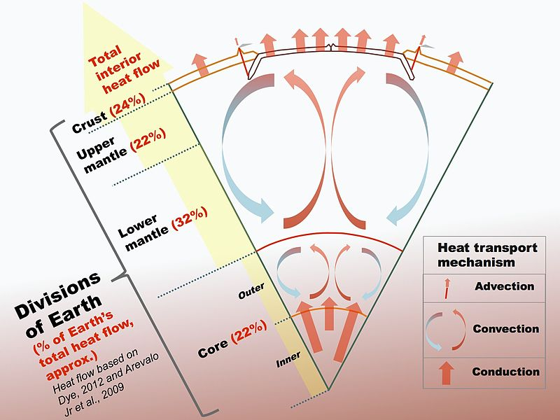
The earth gets hotter at depth. Worldwide, the temperature increases 1.3-2.2°F per 100 feet in depth. The geothermal gradient varies in different places based upon the types rocks at depth and near the surface, plus the circulation of groundwater.1
In the core and mantle surrounding the core, there is residual heat from the collisions that created the earth over 4.5 billion years ago. Much of the heat in the earth's mantle, below the crust, is caused by continuing decay of radioactive materials. Radioactive decay from thorium, uranium, and other radiogenic elements creates higher temperatures where concentrated in granitic plutons, creating some pockets of warmer crust above those plutons. Virginia even has a localized deposits of radioactive uranium exposed at the surface at Coles Hill in Pittsylvania County, but there are no hot springs there.
thermal springs in the area of Warm Springs Mountain are about 20 miles away from where magma reached the surface 47 million years ago during the Eocene Epoch
Source: Wikipedia, Earth's inner core
The geothermal gradient is the steepest where magma chambers are near the surface. In Iceland, Yellowstone National Park, and Northern California, hot material near the surface raises the temperature of rainwater that seeps underground. If the underground pathways ("geologic plumbing") is aligned in certain ways, groundwater can become superheated and flash into steam to create a geyser.
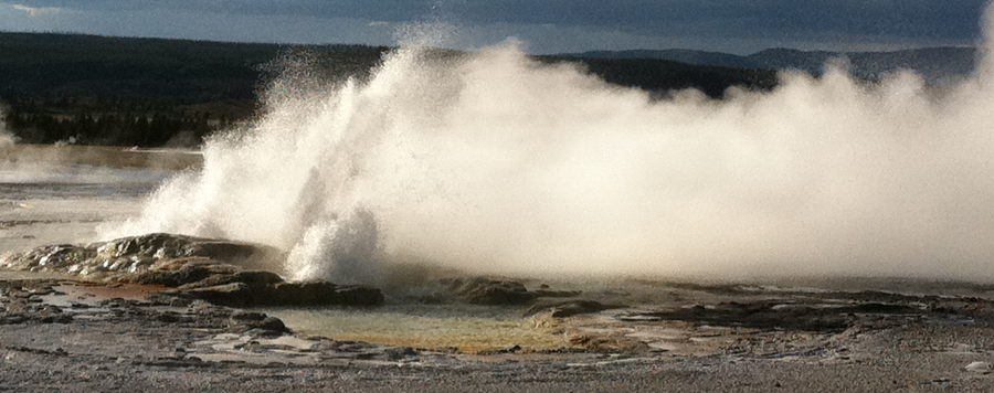
geysers in Yellowstone National Park are generated by water heated at depth, reaching the boiling point, and then surging to the surface
There are warm springs in Virginia today, some of which ebb and flow as changes in water pressure stimulates surges that reach the surface. However, there are no geysers in Virginia; no water emerges at the surface that is anywhere close enough to boil.
The geothermal gradient varies across the Earth's crust. In that part of Virginia with thermal springs, the geothermal gradient averages 1.5°F for every 100 feet of depth. At the elevation of most thermal springs in Virginia's mountains, groundwater would have to travel about 10,000 feet underground in order for the geothermal gradient alone to heat it to boiling temperature and create a geyser.
The average temperature below the frost line is about 48-54°F. Nearly two miles down, that water could be heated an additional 150°F up to boiling temperature (about 207°F at that altitude). No fractures allow rainwater to flow to such a depth and then come back to the surface fast enough to retain enough heat to create a geyser.2
Generating water hot enough to boil without a nearby magma chamber is known to occur at only one location on earth. In the Amazon Basin of Peru, groundwater apparently percolates deep enough to create a "boiling river." Water emerging at the surface reaches temperatures up to 196°F, solely from the increasing heat of the earth at greater depth. The closest known volcanic magma chamber to that Peruvian river is 400 miles away.3
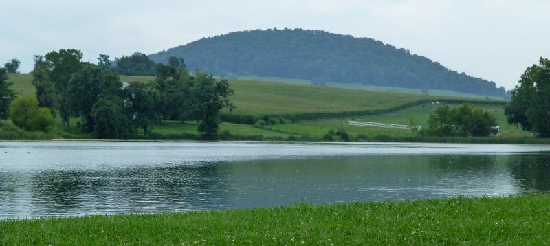
the 48-million year old magma chamber that created Mole Hill has cooled, and the spring that feeds Silver Lake provides 52°F water
Virginia may have had geysers in the past. There were volcanic eruptions in Virginia just 47 million years ago, and the magma would have provided the heat required for geysers as well as more hot springs then. Mole Hill west of Harrisonburg is a volcanic remnant from the Eocene Epoch, and nearby Trimble Knob is another basaltic neck with a magma flow which cooled into columnar basalt.4
Today, no magma chamber is near the crust underlying Virginia; the threat of a volcanic eruption is zero. After 47 million years, whatever magma chamber that triggered Eocene Period eruptions has cooled.
Theoretically, the temperature of thermal springs along Warm Springs Mountain could be related somehow to deep heat sources being relatively closer to the surface in that area. However, the source of heat for Virginia's current thermal springs is the geothermal gradient, the increasing temperature of all rocks at greater depth.
Rain seeps underground, gets heated, and returns to the surface. Analysis of the geochemistry and dissolved gasses in warm springs indicate that the source water was rain falling nearby, feeding both warm and cold springs in the area.5
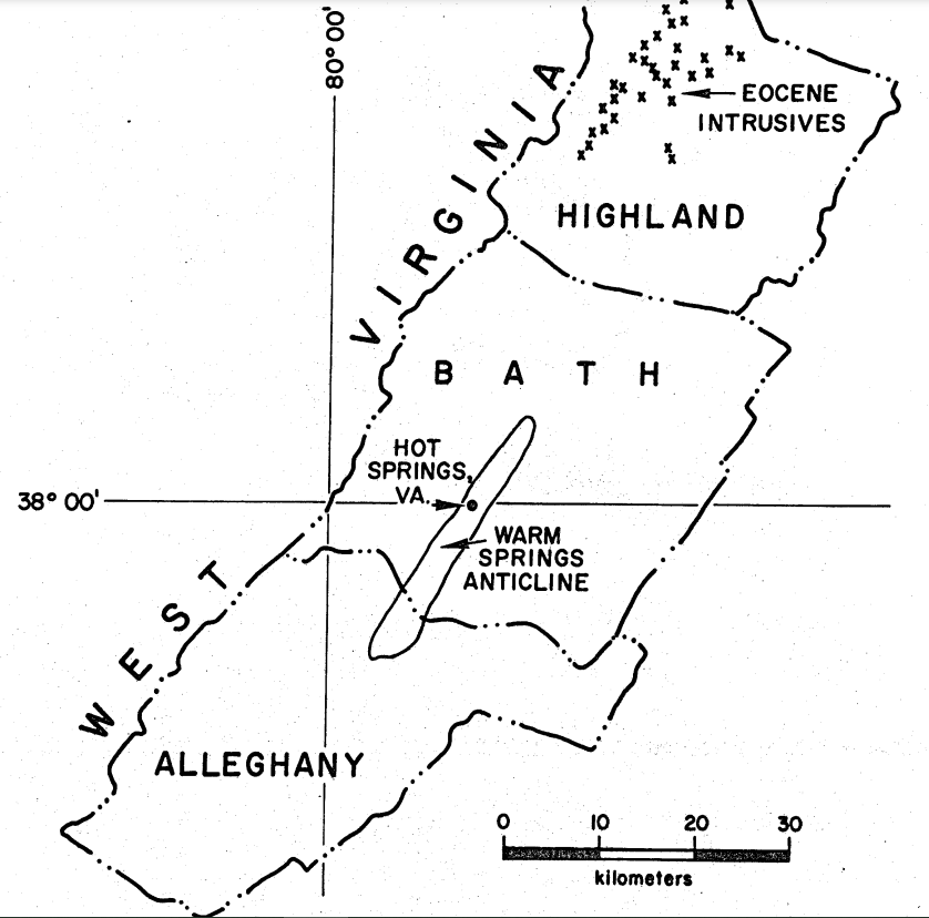
thermal springs in the area of Warm Springs Mountain are about 20 miles away from where magma reached the surface 47 million years ago during the Eocene Epoch
Source: John K. Costain, Geological and geophysical study of the origin of the Warm Springs in Bath County, Virginia (Figure 1)
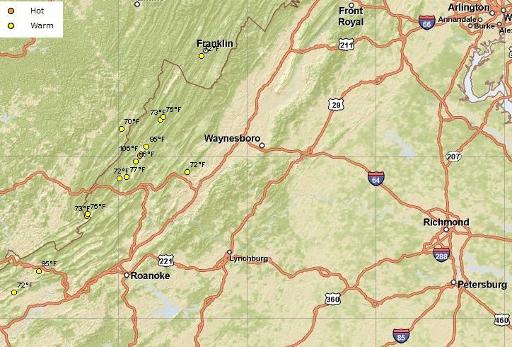
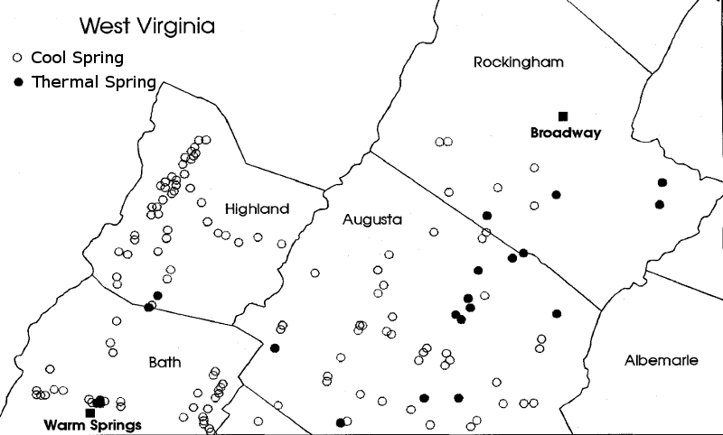
Virginia has many springs fed by groundwater that has traveled deep underground, and 100 or so springs with water temperatures exceeding mean annual air temperature (48-54°F). All thermal springs in Virginia are located in the Valley and Ridge province.
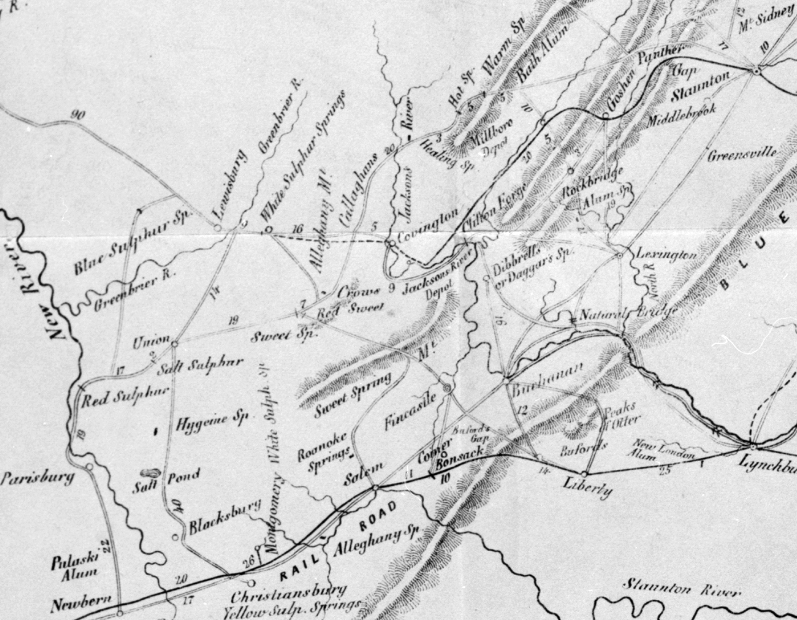
thermal springs in Virginia are concentrated in valleys between Pulaski and Bath counties
Source: Library of Congress, The Virginia Springs, and the Springs of the South and West by Moorman
Rainwater feeding the warm springs travels deep underground through sandstone and limestone formations. It rises through fractures and solution channels, moving fast enough that it retains residual heat when emerging at the surface as a spring. Though there may be many springs in Virginia where the source water travels deep enough to warm substantially, there are few where the warmed water returns to the surface before that heat is fully dissipated.
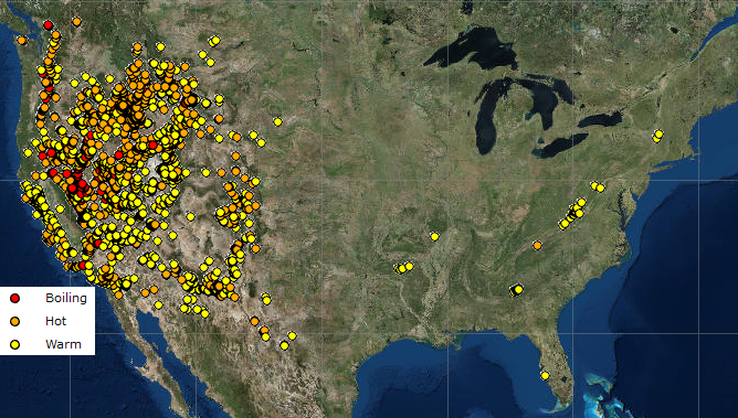
nationally, most thermal springs are located in the western United States
Source: NOAA National Geophysical Data Center Thermal Springs
The 20 thermal springs that are most clearly recognized in Virginia include some where seepages next to each other are combined to form one named spring:6
Major Thermal Springs in Virginia7
| Name | Temperature |
| Alum Springs | 72°F |
| Blue Ridge Springs (Buford's Gap) | 66-75°F |
| Bolar Springs | 73°F |
| Bragg Spring | 75°F |
| Dice's Spring | 65°F |
| Falling Spring | 77°F |
| Fitzgerald Spring | 61°F |
| Healing Springs (Rubino Healing, Sweet Alum) | 86°F |
| Hot Springs | 106°F |
| Hunter's Pulaski Alum Springs | 72°F |
| Layton Springs (Keyser's) | 63°F, 72°F |
| Limestone Springs | 61-6°F |
| Lithia Spring (Wilson Thermal) | 65°F |
| McHenry Spring | 68°F, 65°F, 66°F |
| Mill Mountain Springs | 60°F, 65°F, 66°F |
| New River White Sulphur Springs | 85°F |
| Rockbridge Baths (Rockbridge Alum, Strickler's) | 72°F |
| Sweet Chalybeate Springs | 63-76°F |
| Warm Spring (Rockingham County) | 64°F |
| Warm Springs (Bath County) | 95°F |
The Ordovician limestone and Cambrian sandstone bedrock formations through which the thermal spring water travels were deposited 450-550 million years ago, but the water in the springs is recent rainfall. It seeps underground, is heated by the warmer rock 2,000-5,000 feet underground, then returns to the surface quickly enough to retain that geothermal heat. The Warm Springs resort has advertised that it had 98° water in its public baths.8
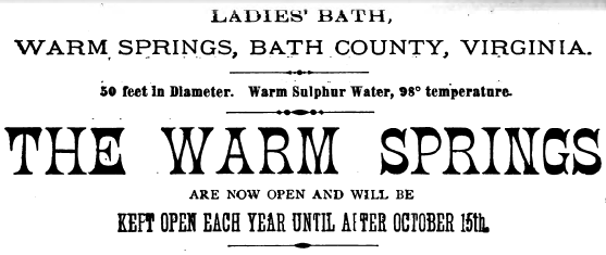

the Ladies Bath at Warm Springs Pool advertised 98℉ water
Source: "The Chesapeake & Ohio Railway Directory, Containing an Illustrated History and Description of the Road," Ladies' Bath, Warm Springs, Bath County, Virginia (p.331)
At Hot Springs and Warm Springs, the water has been underground at least 20 years before re-emerging at the surface. At many, many other springs in Virginia, groundwater moves to the surface slowly. What could have been a "warm spring" ended up as just an "ambient temperature spring," because the water cooled before emerging at the surface.
The geothermal gradient within the crust is affected at the surface by summer and winter temperature changes. People who get their drinking water from a well 300 feet deep know that the water is cold in July. The geothermal gradient will warm groundwater 1.5°F per 100 feet, but that warming is not reflected in shallow wells where the ground temperature is determined by the annual average temperature.
The average year-round temperature is cooler than the air temperature in the summertime, and the groundwater feeding most springs does not travel deep underground. That is why most springs disgorge cool water in June-September. To take advantage of natural refrigeration, springhouses were built by early settlers to chill milk/butter/cheese. They were used until electricity reached rural areas, in some places after World War II.
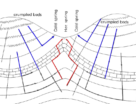
possible movement of ground water through a multilayered folded/faulted/fractured aquifer, or a faulted/fractured anticlinal ridge
Source: US Geological Survey (USGS), Hydrology and Geochemistry of Thermal Springs of the Appalachians (Professional Paper 1044-E, Figure 9 and Figure 11)
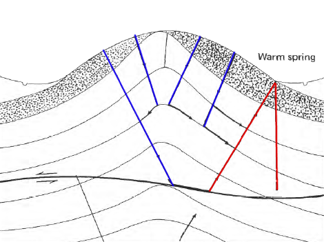
At Warm Springs, the surface water percolates one mile below the surface. It flows down through the sedimentary rock layers until it reaches a resistant layer and is pushed upwards, emerging in a valley quickly enough to retain some of its geothermal heat aquired at depth.
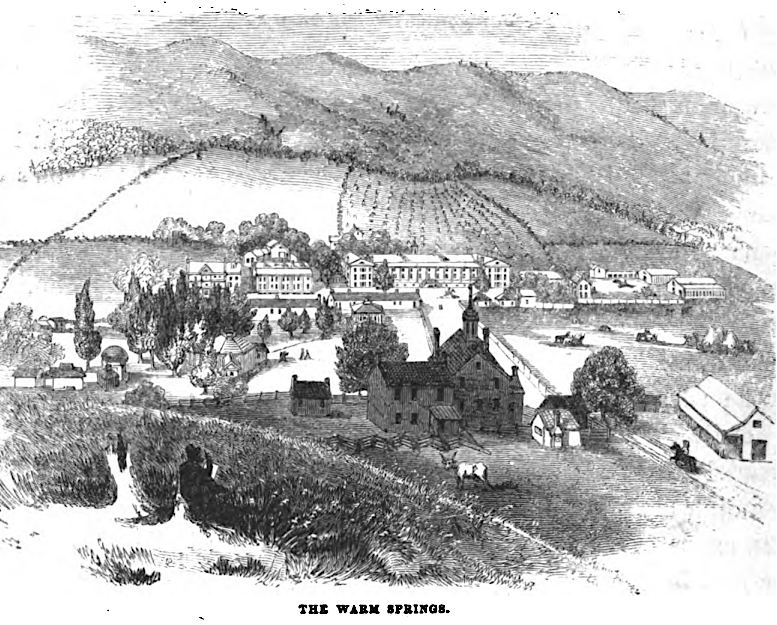
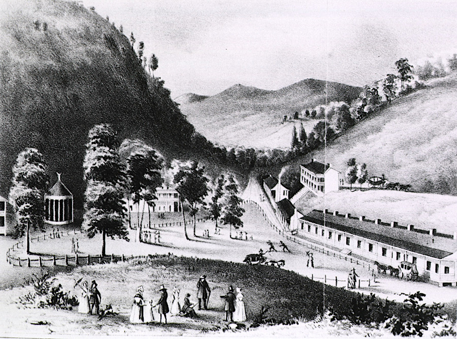
Warm Springs was a gathering spot for the Virginia wealthy, prior to the Civil War
Source: David Hunter Strother, Virginia Illustrated (1871, p.134)
Cool groundwater closer to the surface may mix with warmer water from greater depth. The temperature of Bolar Spring drops as the flow increases, suggesting that warm water from greater depth dominates during dry periods but cooler water from near the surface is mixed in after rains.
David Hunter Strother in his 1855 visit described how the resort proprietor at Hot Springs took advantage of the different temperatures:9
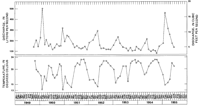
the temperature at Bolar Spring drops when flow increases, as cooler water from nearer the surface mixes with warmer water from greater depth
Source: US Geological Survey (USGS), Hydrology and Geochemistry of Thermal Springs of the Appalachians (Professional Paper 1044-E, Figure 18)
thermal and cool springs are intermixed in western Virginia; in most cases, groundwater does not circulate deep enough or return to the surface fast enough to retain geothermal heat
Source: Virginia Minerals, Ancient warm springs deposits in Bath and Rockingham Counties, Virginia (May 1997)
The hot springs at the modern Omni Homestead Resort have been used for at least 9,000 years. Ever since Paleo-Indians arrived about 20,000 years ago, it is likely that people have luxuriated in the 106°F natural hot tub on cold winter days and nights. When no humans were in the area, wildlife would have kept warm near the thermal springs as well.
The oldest spa structure in the United States is at Warm Springs Pool, five miles away from the Homestead Resort. The original octagonal limestone basin that held water for bathing at a Warm Springs Pool was built in 1761. Native Americans had visited the site for up to 20,000 years before European colonists built their first structure.
A later wooden structure, now known as the Gentlemen's Bath House, was built to cover the hot springs in the 1820's. The Ladies' Bath House was built in the 1870's and the Reception House in the 1890's. The Warm Springs Hotel was located next to the Warm Springs Pool until that structure was demolished in the 1920's. The Homestead Resort, located five miles away, purchased what were called the "Jefferson Pools" in 1925.
Bath County required closure of the Jefferson Pools for safety reasons in 2017; the old wooden structures had rotted, and were in danger of collapsing. Omni Homestead Resort rehabilitated the buildings in 2021-2022 in a $4.6 million project and reopened them to the public on December 17, 2022. In the process, the historic name "Warm Springs Pools" was restored to the springs.10
Thomas Jefferson described two warm medicinal springs in his Notes on the State of Virginia:11
At the time, Hot Springs and Warm Springs were in Augusta County. Bath County was not chartered until 1790.12
The warm springs at Berkeley (now in Morgan County, West Virginia) were more popular in the 1780's. George Washington first saw them in 1748, working as a surveyor for Lord Fairfax. He described visiting them again in 1761:13
Jefferson had a low opinion of the Berkeley Springs:14
Jefferson wrote his assessments of the springs without having visited any of them in person. He finally went to Warm Springs and Hot Springs in Bath County in 1818, to relieve symptoms of rheumatism. He bathed in Warm Spring three times a day, but found the experience boring:15
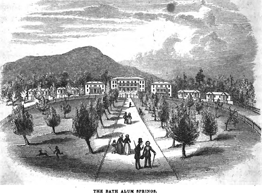
Prior to the Civil War, mountain springs were developed as entertainment resorts for the wealthy, especially those living in Tidewater who desired to escape the heat and humidity in the days before air conditioning. The chemicals in the water, including alum and sulfur, were thought to help invalids recover their health.
in the 1800's, water at the Red Sulfur Springs resort in Monroe County were thought to have curative values
Source: National Library of Medicine, Red Sulphur Springs, Va.
David Hunter Strother, under the pen name Porte Crayon, visited multiple resorts built around the springs prior to the Civil War. He described the Hot Springs in 1855:16
David Hunter Strother (pen name Porte Crayon) visited several resorts based on mineral/thermal springs in 1855
Source: David Hunter Strother, Virginia Illustrated (1871, p.130)
Today, the water from the Hot Springs is piped to The Omni Homestead spa, where it fills bathtubs (for single-person use) and indoor/outdoor swimming pools.17
Springs enriched with alum would purge the bowels, while sulfur-enriched and iron-enriched (chalybeate) springs were thought to offer a cure for various illnesses. Even without claims of chemical impacts, thermal springs provided comfort and distraction from aching bones and itching skin. The healing power of springs was once expected to trigger a population increase and economic boom in western Virginia:18
As medical knowledge expanded, the public lost faith in the capacity of mineral springs to cure rheumatism and other ailments. The invention of air conditioning also lowered demand for summer vacations in the mountains. Except for The Homestead in Hot Springs, none of the mineral spring resorts in Virginia have survived as an overnight tourist destination.
After the Japanese attacked Pearl Harbor on December 7, 1941, the Greenbrier Resort in nearby White Sulfur Springs, West Virginia and The Homestead hosted interned Japanese diplomats. A special underground wing was built at The Greenbrier during the Cold War to serve as a relocation space for the US Congress, in case Washington DC had to be evacuated. A 1992 story in the Washington Post revealed th secret facility, and today The Greenbrier offers "bunker tours" to tourists.19
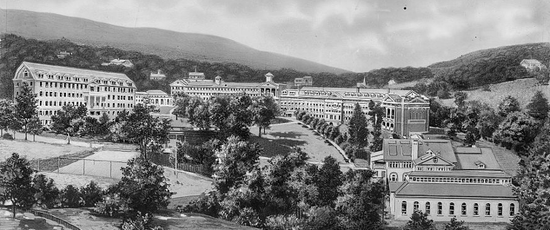
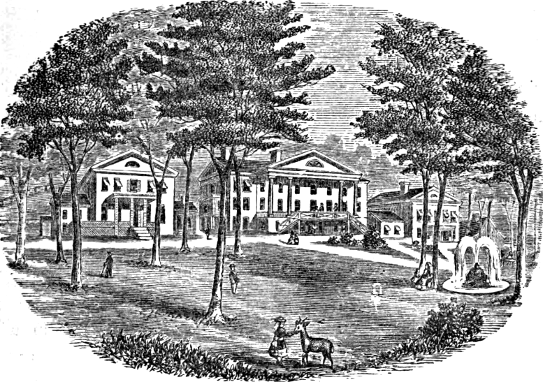
the Homestead Resort in Bath County, sometime between 1890-1910
Source: Library of Congress, Virginia Hot Springs, Va., the Homestead
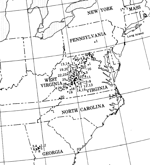
in the Eastern United States, warm springs extend from Saratoga Springs in New York to Warm Springs in Georgia
Source: US Geological Survey (USGS), Thermal Springs of the United States and Other Countries of the World - A Summary (Professional Paper 492)
Bath County's economy relies upon tourists visting resorts with warmer-than-average water
Source: "The Chesapeake & Ohio Railway Directory, Containing an Illustrated History and Description of the Road," Healing Springs (p.332)