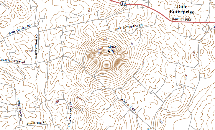
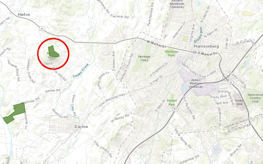
Mole Hill is volcanic basalt that erupted 48 million years ago, and the remnant plug erodes slower than surrounding limestone west of Harrisonburg
Mole Hill is volcanic basalt that erupted 48 million years ago, and the remnant plug erodes slower than surrounding limestone west of Harrisonburg
Virginia has a long history of eruptions and volcanic activity. Some of the oldest rocks in Virginia, the core of the Blue Ridge, were the molten roots of the Greenville Mountains. Those igneous rocks crystallized over one billion years ago as the supercontinent of Rodinia formed, and through erosion were exposed at the surface 400 million years later.
The highest spot in Virginia, Mount Rogers, is formed from lava that erupted 750 million years ago. The supercontinent of Rodinia was starting to break up; the initial rifting thinned the crust and allowed magma to reach the surface. That cracking of the supercontinent ended before the tectonic plate split apart to form a new ocean, so Mount Rogers is formed from silica-rich rhyolite from melted continental crust rather than the basalt that forms the islands of Hawaii.
There are three major types of volcanoes. The volcanoes of Hawaii are located at a "hotspot" where eruptions occur in the middle of a tectonic plate. The second type is exemplified by the Cascade Range and other volcanoes along the western edge of the North American Plate. They form where oceanic crust of one continental plate is being subducted (driven underneath another plate) and melted at depth. The Pacific Ocean is surrounded by a "Rim of Fire" with similar volcanoes stretching from the Andes in South America to the islands of Japan.
The Mid-Atlantic Ridge is a third type, where tectonic plates are pulling apart and magma pushes to the surface. That process also is occurring at the Red Sea and is splitting Eastern Africa now. There is also a unique way for magma to reach the surface at Mount Etna in Italy. That process, rather than a hotspot, may also be the cause of the geysers and boiling mud pots at Yellowstone National Park.
Continental crust is rich in silica. When remelted and extruded at volcanoes such as Mount Rogers, the cooled rock is often rhyolite. Continental crust is less dense compared to the original oceanic crust, because minerals with silica and oxygen become concentrated as tectonic plates collide and melt. Over the earth's history, the percentage of continental crust is gradually increasing as minerals are differentiated in tectonic collisions.
Rhyolite has a mineral composition similar to granite, but a different crystal size. Rhyolite crystals are much smaller than granite crystals because rhyolite erupting on the surface cools much quicker than granite cooling slowly at great depth underground. The igneous rock associated with ocean basins, basalt, has higher percentages of iron and magnesium and less silica than rhyolite.
The largest exposure of igneous rock in Virginia is in the Blue Ridge. That mountain range has silica-rich granite in the core, with a coating of silica-poor basalt extruded on top. Those two forms of once-molten magma were created at different times under different conditions.
The core of the Blue Ridge was formed when plates of continental crust combined one billion years ago to form the supercontinent of Rodinia. The collision of two silica-rich tectonic plates resulted in a silica-rich granite. Volcanoes must have been a major feature on the landscape during the collision, but erosion has removed the original mountains formed a billion years ago. The volcanic lava and ash have been recycled into new crust.
However, erosion has exposed the once-deep roots of the mountains created in the Greenville Orogeny. The mountains that were once nearly five miles high also had roots that were five miles deep. Today we can see the ancient deeply-buried granite and gneiss exposed at Old Rag Mountain and along Skyline Drive in Shenandoah National Park.
volcanic features created during different mountain-building collisions of tectonic plates (orogenies) have eroded off Virginia's land surface
Source: National Park Service, This Dynamic Earth
About 400 million years after the Grenville Orogeny produced that granite, the supercontinent Rodinia broke apart. In a process similar to what is underway in Africa today, Rodinia divided into separate tectonic plates about 575 million years ago. Basalt, with a low-silica mineral composition similar to what is emerging today at the Mid-Atlantic Ridge, erupted in the crack. That magma reached the surface and flowed on top of the one billion year old core granite.
If the core granite is considered to be an ice cream cone, the lava on top could be considered a chocolate coating. The younger basalt lava flows were later buried and metamorphosed into Catoctin greenstone that includes epidote, a metamorphic mineral which is light green in color. Catoctin greenstone is now well-exposed in Shenandoah National Park and along the Blue Ridge Parkway, and in roadcuts on Route 29 between Charlottesville-Warrenton. Buried underneath the "young" Catoctin greenstone is the older granite roots from the Greenville Orogeny mountains.
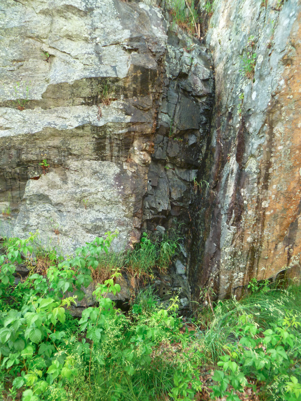
dike of 575-million year old Catoctin basalt cutting through Grenville-age (1.1 billion year) bedrock in Shenandoah National Park
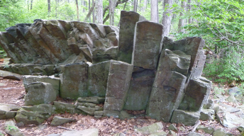
columnar basalt in Shenandoah National Park, formed after lava flows cooled roughly 575 million years ago
After Rodinia split up, the North American Plate was south of the equator and rotated so the modern east coast was facing towards the South Pole. Since then the plate has moved north and twisted counter-clockwise.
The eastern edge of the North American plate also has been expanded. A series of island arcs, similar to Japan and Indonesia today, were "accreted" to the edge ofthe continent as the Iapetus Ocean slowly closed. Today those island arcs are the different terranes of the Piedmont, and undely the sediments of the Coastal Plain. The igneous rocks from the many volcanoes on those island arcs were squished and metamorphosed into schist. At the modern surface, most of that metamorphic schist had decomposed into saprolite but hard bedrock is exposed at Great Falls, Nottoway Falls, and in streambed at other places in the Piedmont.
Accretion of the island arcs was followed by collision with the African tectonic plate. The Ancestral Appalachians formed 300-250 million years ago when the two plates collided to form Pangea. Because both plates consisted of continental rather than oceanic crust, the collision compressed the two plates rather than created a line of subduction volcanoes and created a mountain range. The same process us underway today where the Indian plate is colliding with the Eurasian plate and pushing up the Himalayan mountain range.
The Ancestral Appalachians in Virginia were roughly where I-95 is located today. Again, the roots were as deep as the mountains were high above the surface. The uplifted crust on the surface has washed away over time; the eroded remnants are now the sediments on the Coastal Plain and stretching west towards Chicago. The volcanic roots of the Ancestral Appalachians, the slow-cooling granitic magma that once was buried as much as five miles deep, are exposed now in granite and grandiorite quarries stretching from Lorton to Emporia.
The supercontinent of Pangea lasted about 100 million years, then heat trapped underneath caused it to split up. As the overlying crust stretched and thinned, its weight was spread across a wider area. Crustal stretching reduced the pressure that had suppressed the hot magma 5-10 miles deep from rising to the surface. Basalt from deep below reached the surface of Virginia again about 200 million years ago. This happened during the Triassic Period, a time when dinosaurs were becoming the dominant form of life on land.
The crustal cap broke at multiple places, creating valleys that resemble stretch marks. Those valleys, now called Triassic basins, appeared where the crust sank. Sediments from the Ancestral Appalachians filled them, in some places as much as 25,000 feet deep.
The thin crust in those valleys allowed low-silica basalt to reach the surface and spread as lava, similar to the eruption of what is now Catoctin greenstone. In many locations, hot magma rose to a spot near the surface but lacked the energy/pressure to break all the way through the sedimentary layers on top. The hot rock cooled while still underground, baking the sedimentary layers nearby to create "hornfels." The basalt which did not erupt chilled into dikes (where magma cuts through sedimentary layers) and sills (where magma intruded between the layers).
Later erosion removed the overlying sediments. Triassic dikes are found today in the Piedmont, Blue Ridge, and Valley and Ridge provinces, indicating where the magma rose up as the crust cracked and the overlying pressure was reduced. Such dikes also exist east of the Fall Line, but that basalt is buried beneath Coastal Plain sediments which eroded from the Ancestral Appalachians.
Vasalt in the Piedmont is harder than sandstone and shale in the Triassic basins. East of the Blue Ridge, the exposures of volcanic rock are a valuable resource. Quarries crush the basalt into different sizes of gravel used in road and building construction. Sandstone, mud metamorphosed into shale, and hornfels are also quarried where the sedimentary rock was compressed/heated enough so it can withstand the pounding of heavy trucks on highways today.
As a result of tectonic shifts, Virginia has granite "roots" that are a billion years old in the Blue Ridge, 750 million years old at Mount Rogers, and 300-250 million years old from the Ancestral Appalachians along I-95. The state has 575 million year old basalt on the Blue Ridge (now metamorphosed into Catoctin greenstone) and 200 million year old basalt in dikes/sills dating from the breakup of Pangea. Terranes in the Piedmont have once-volcanic rocks that have been metaorphosed into schist since they were accreted onto the North American plate.
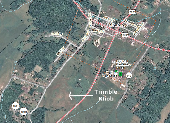
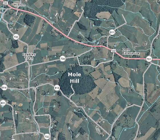
Virginia also has the youngest volcanoes on the East Coast: 200-foot high Trimble Knob in Highland County, and 150-foot high Mole Hill in Rockingham County. Young is a relative term - Mole Hill is 48 million years old. Trimble Knob formed at the same time, though some of the volcanic material there has been dated at only 35 million years old.1
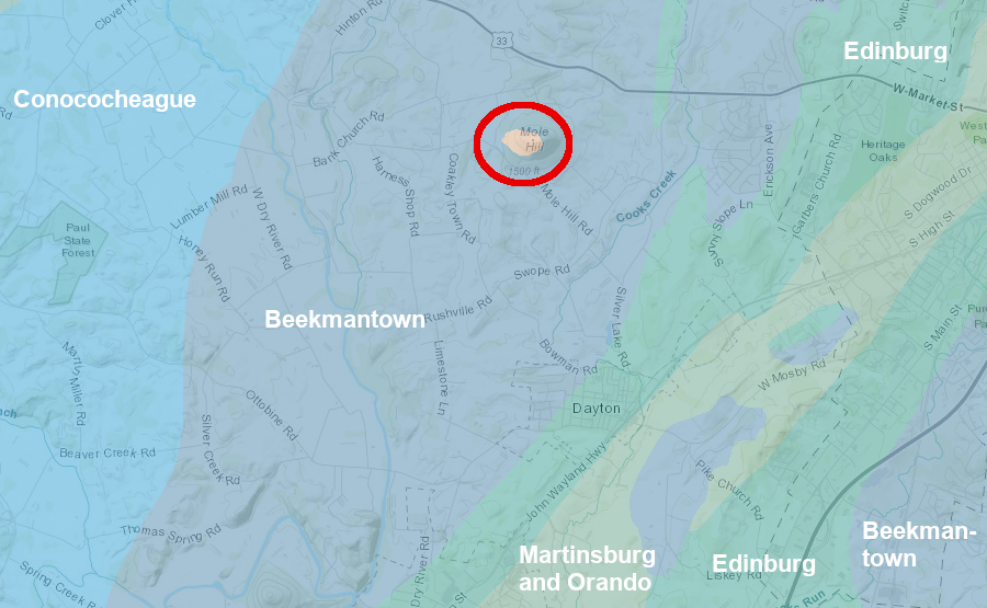
Mole Hill has been slower to erode than surrounding shale and limestone
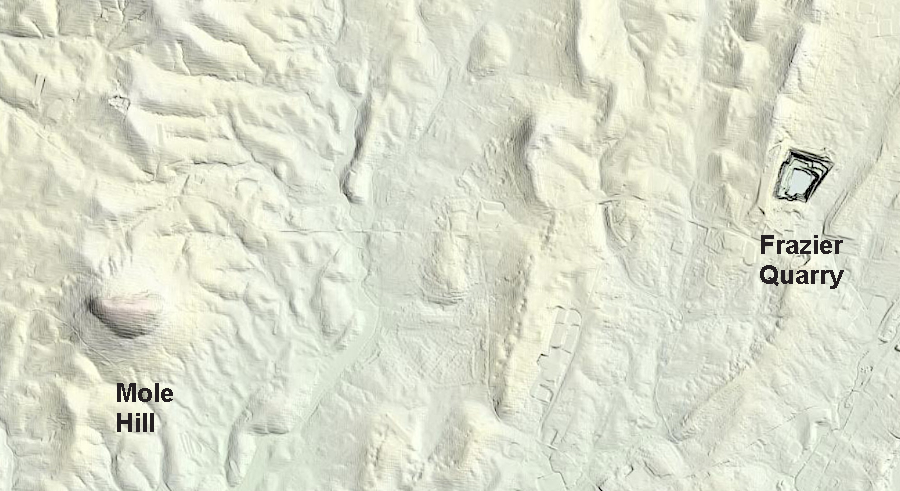
the quick excavation of the Frazier Quarry provides a contrast to the slow differential erosion that produced Mole Hill
Source: National Aeronautics and Space Administration (NASA), Virginia’s Volcanic Past; US Geological Survey (USGS), The National Map
The volcanic rock at Mole Hill and Trimble Knob intruded through the sedimentary layers west of the Blue Ridge during the Eocene Epoch. At that time, as it is now, Virginia was on the passive margin of the North American plate. Volcanic eruptions were in the center of the Atlantic Ocean, on the Mid-Atlantic Ridge.
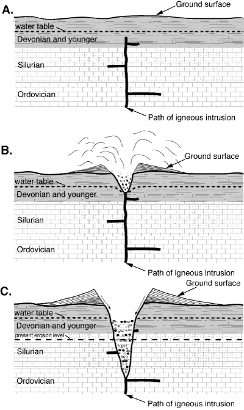
For some reason, Virginia's chunk of crust was squeezed by tectonic shifts, perhaps as the North American Plate rotated slightly in its drift westward. Changing pressures may have rejuvenated old Paleozoic faults. As the crust weakened and cracked 42-50 million years, basalt rose from 18 miles deep in the mantle. Dikes of that "young" basalt (compared to dikes that formed in the Jurassic Period as Pangea split up) are found as far to the west as Pendleton and Pocahontas counties in West Virginia.
At Trimble Knob, the molten lava moved at 40-70 miles/hour up to the surface. The trip from magma chamber to the surface took less than four days. It encountered groundwater and, in a burst of exploding steam, formed a crater on the surface. Erosion has removed the crater but exposed the magma in the channel leading to the surface.2
distinctive geology of Mole Hill, west of Harrisonburg in Rockingham County
Source: Virginia Department of Mines, Minerals and Energy,
Publication 159: Geologic Map of the Augusta, Page, and Rockingham Counties Portion of the Charlottesville 30 x 60-minute Quadrangle
Roughly 100 outcrops similar to Trimble Knob splatter the geologic map of Highland and Rockbridge counties, and west to Ugly Mountain in Pendleton County, West Virginia. A 12-inch layer of lava was intruded into the horizontal layers of limestone at Natural Chimneys at roughly the same time when the Mole Hill diatreme formed.
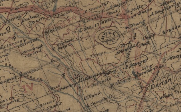
Mole Hill, as shown on Jedediah Hotchkiss's 1862 map
Source: Library of Congress
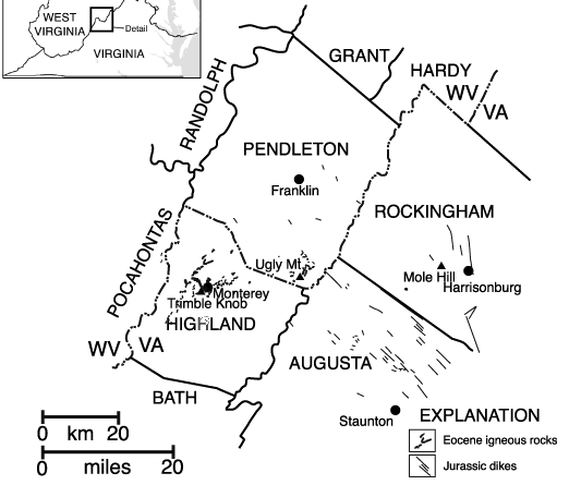
area of young (Eocene) volcanics in Virginia plus older (Jurassic) dikes dating to formation of Atlantic Ocean
Source: US Geological Survey (USGS), Middle Eocene Igneous Rocks in the Valley and Ridge of Virginia and West Virginia
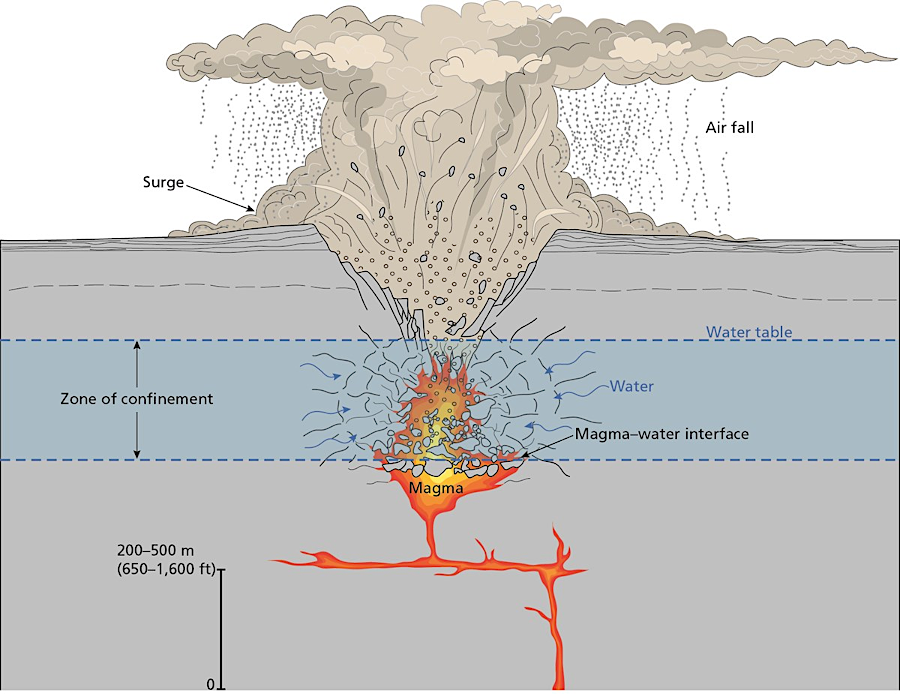
Both Trimble Knob and Mole Hill appear to be "diatremes," formed when magma intercepted shallow groundwater. Near the surface at a depth equivalent to the length of a football field, the water flashed into steam and erupted through the overlying sediments, creating a crater called a "maar" which fills with fragments of magma (tuff) and broken surface rock. Rainwater can accumulate in the new crater, forming a lake until erosion carves a channel in the edge of the maar.
The steam explosion and maar formation occur in just a few minutes:3
Trimble Knob and Mole Hill are remnants of eruptions that occurred when magma encountered groundwater near the surface and formed a central collapse crater (maar)
Source: National Park Service, Diatremes and Maars
Today, we do not see the original surface where the magma and steam erupted. Over the last 35-48 million years, 1,100 feet or more has eroded away, removing nearly all of the volcanic residue around the maar. The igneous remnants of the eruption that were trapped in the maar have been slower to erode that the nearby limestone and dolomite, so topography has been reversed. The crater formed 48 million years ago is now a hill due to differential erosion.
In a similar scenario, Devils Tower in Wyoming and Ship Rock in New Mexico may have formed when magma reached groundwater and created a central collapse crater (maar). The tower remains today as an isolated feature, because the volcanic residue and the edges of the maar have eroded away.4
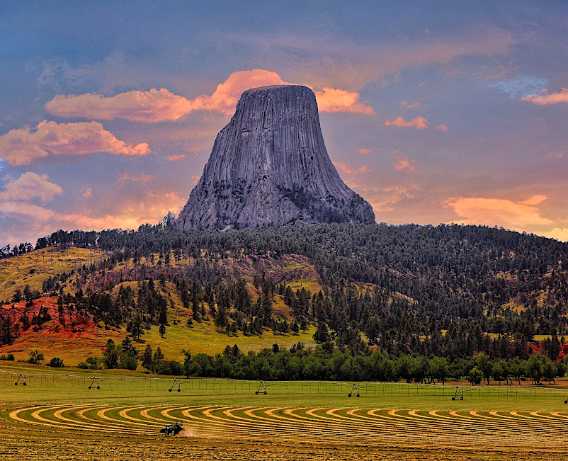
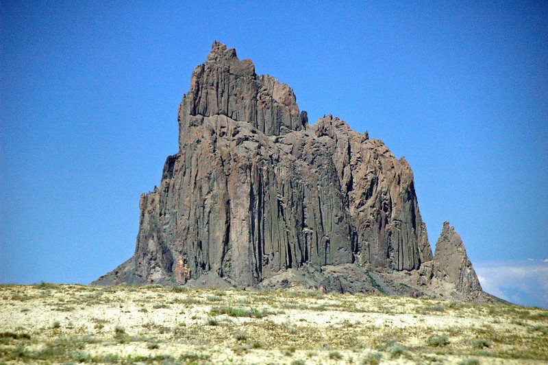
like Trimble Knob and Mole Hill, Devils Tower in Wyoming and Ship Rock in New Mexico were part of diatremes
Source: Recreation.gov; Flickr, Ship Rock (Oligocene; Navajo Volcanic Field, northwestern New Mexico, USA)
Some diatremes include kimberlite "pipes" with diamonds that had formed deep at the crust-mantle boundary. Small kimberlite pipes has been found in Virginia near Mount Horeb Church (Rockbridge County) and Front Royal (Warren County). Five diamonds have been found in Virginia, but none of them can be associated with any source rock.5
The trigger for the young Eocene eruptions in Virginia is unclear. It could have been caused by a "hotspot" similar to what created the Hawaiian Islands and now underlies Yellowstone National Park. The crust could have thinned and allowed hot magma to rise when a continental rift began to expand, perhaps associated with reactivation of the New Madrid fault in Missouri.
However, the temperature of the basalt at Mole Hill was roughly 1,400°C. Hot spot magma reaches above 1,500°C.

in the Eocene Epoch, Virginia was on the passive margin of the North American continent
Source: Dr. Ron Blakey, Paleogeography and Geologic History of North America
The heat source might be elated to the subduction of oceanic lithosphere underneath the North American Plate during the Taconic or Neo-Acadian orogenies, 300-450 million years ago. That plate may still be sliding into the mantle. If it stirred up a current of hot mantle material that rose close enough to the surface, volcanism might have been triggered in the Eocene epoch.
Another possibility is that a chunk of a subducted crustal plate finally melted and dripped quickly into the mantle. The disruption of the chemical and heat balance could have triggered a burst from the mantle, pushing up a tower of magma that reached all the way to the surface.6
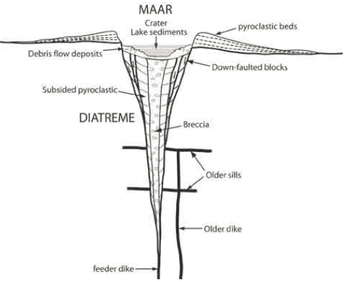
diatremes create a narrow path cutting through overlying rocks, and increase in depth through multiple steam explosions
Sources: Virginia Department of Mines, Minerals and Energy,
Eocene Igneous Rocks Near Monterey, Virginia: A Field Study and US Geological Survey (USGS),
Middle Eocene Igneous Rocks in the Valley and Ridge of Virginia and West Virginia
Because the cooled lava in the diatreme tube and maar has eroded slower than the surrounding limestone, the topographic relief is not flat. The volcanic plugs at Trimble Knob and Mole Hill stand out today due to differential erosion. A professor at James Madison University stated:7
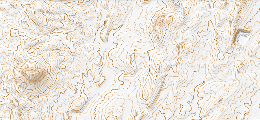
Mole Hill is clearly visible west of Harrisonburg because the surrounding limestone has eroded away faster than the igneous basalt
Source: US Geological Survey (USGS) 7.5-minute map for Bridgewater, VA (2016)
Mole Hill is 350 higher than the surrounding limestone valley. With relatively-steep slopes, it is less-suitable for grazing and is completely covered by trees. Trimble Knob, in contrast, is grazed heavily by sheep, and the vegetation on the volcanic rock is not distinctive from grass in the surrounding pasture.
Trimble Knob, southwest of Monterey (Highland County)
Source: US Geological Survey (USGS) National Map
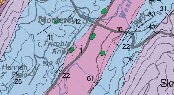
some of the Eocene-age volcanics (in green) near Monterey in Highland County
Source: US Geological Survey (USGS) National Geologic Map Database,
Geologic map of the Virginia portion of the Staunton 30 X 60 minute quadrangle
At Mole Hill, 47 acres are protected by a conservation easement held by the Virginia Outdoors Foundation. In 2008, the landowner had sought to conserve the land, but he died in a tractor accident before completing the process The property was purchased from the estate by a neighbor who then donated the easement.8
much of Mole Hill is protected by a conservation easement held by the Virginia Outdoor Foundation
Source: Virginia Outdoor Foundation, VOF Conservation Land
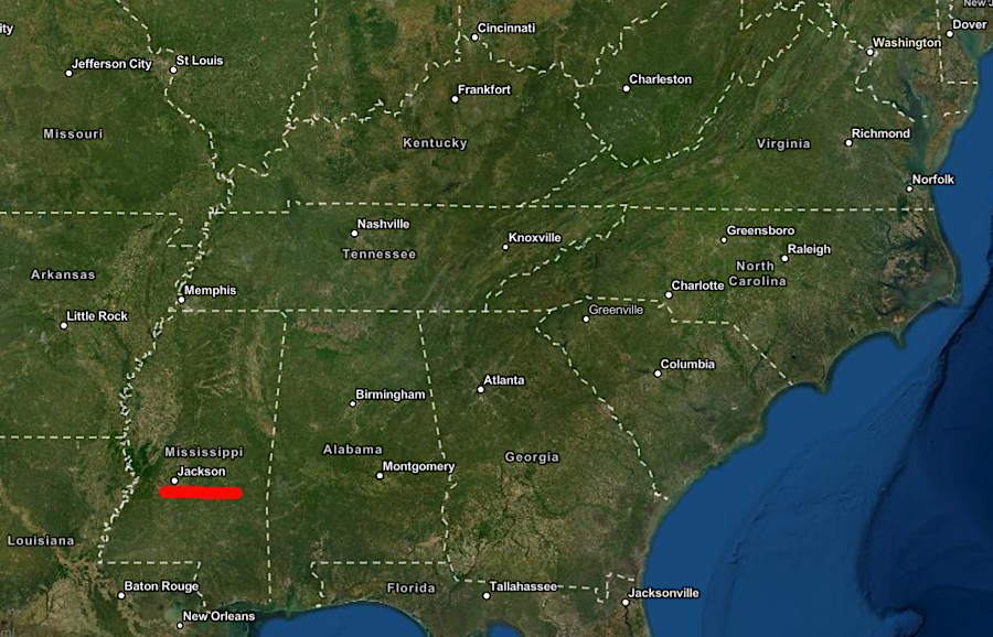
The most recent volcano near to Virginia is in Mississippi. The Jackson Volcano is buried 2,900 feet deep there. It was active until about 70 million years ago. Magma from the Jackson Volcano itself never reached the surface, but there were eruptions on the surface nearby. By the time the dinosaurs died 66 million years ago, that volcanic field had cooled.
On earth today, there are 1,500 volcanoes on land which have erupted within the last 10,000 years. The largest is Mauna Loa on the island of Hawaii. Within the United States, there are 161 active or potentially active volcanoes.9
The closest to Virginia is the Valles Caldera near Santa Fe, New Mexico, about 1,200 miles away. It is closer to the southwestern tip of Virginia than the Saba volcano in the Netherlands West Indies, east of Puerto Rico and the Durango volcanic field on the eastern edge of the Sierra Madre Occidental in Mexico. The Valles Caldera is also closer that the erupting lava vents in the Mid-Atlantic Ridge, east of Virginia's eastern shoreline.10
Typically, at least 20 volcanoes are erupting at any one time on the land. Since the end of the last Ice Age 12.000 years ago, over 1,300 volcanoes have erupted on land. In recorded history, there have been documented eruptions from 560 separate volcanoes.
Most igneous activity is literally out of sight. There are perhaps a million underwater volcanoes concentrated along mid-ocean ridges. About 75% of the annual output of magma emerges from those volcanoes.
Where magma is low in silica, the molten rock ooze out of he ground and gradually builds shield volcanoes such as Mauno Loa. If magma is relatively rich in silica, it captures gas and is more explosive. "V1" on the volcanic explosivity scale describes a volcano that will have a nonexplosive eruption, while a "V8" will have a colossal eruption. The Mount St. Helens eruption in 1980 is classified as a V5. The most recent V8 eruption was in what is now called Taupo, New Zealand, 27,000 years ago.
When "supervolcanoes" erupt, they drain the magma chamber as gas and ash explode into the sky. Rather than create a volcanic cone, supervolcano eruptions create a depression (caldera) in the ground as the surface collapses into the now-empty magma chamber.
Yellowstone National Park is located within a caldera. No caldera has been identified in Virginia, but one or more may have existed and then eroded away. There are three remnants of volcanic eruptions at Mount Rogers, where over 700 million years of erosion has removed whatever volcanic cones were originally formed.11
eruptions on land capture attention, but most igneous activity in underwater at mid-ocean ridges
Source: Smithsonian Institution, What was erupting in the year...?
The Virginia volcanoes are not the only ones east of the Mississippi River. The capital of Mississippi, Jackson, was built on a dome uplifted by a 70-million year old volcano. The now-solid igneous rock of the Jackson Volcano lies 2,900 feet below the Mississippi Coliseum in downtown Jackson, next to I-55. A well drilled for natural gas ended up being an artesian water well supplying a swimming pool with 92.5°F water.
The Midnight Volcano nearby was also part of a Cretaceous Period "rim of fire" in the Gulf of Mexico that stretched from Mississippi to Mexico. Eruptions ceased before the Chicxulub impact 66 million years ago killed off all of the dinosaurs except their modern descendants, the birds.12
other extinct volcanoes east of the Mississippi River are at Jackson, Mississippi
Source: ESRI, ArcGIS Online
Though Mole Hill is the site of the most recent volcanic activity east of the Mississippi River, there is little potential of an eruption in Virginia now. The most likely scenario for that to occur is that the Atlantic Ocean would stop expanding from the Mid-Atlantic Ridge. If tectonic pressures shifted and the eastern edge of the North Atlantic Plate began to subduct under the European Plate, then a new rift valley could form and volcanoes could reappear in Virginia.
Another possibility is that a new spreading center parallel to the Mid-Atlantic Ridge could form at the current edge of the Continental Shelf. Subduction of oceanic crust underneath the continental crust would then spur new volcanoes, perhaps comparable to the Cascades in Oregon and Washington. Cracking of the North American Plate to form a new rift valley or spreading center is to be expected over geologic time, but the process will involve many millions of years. The risk of any human seeing fresh lava flow in Virginia in their lifetime is very, very, very low.
Dr. Jim Beard at the Virginia Museum of Natural History has commented that outside of of a new subduction zone forming in the Atlantic Ocean:13
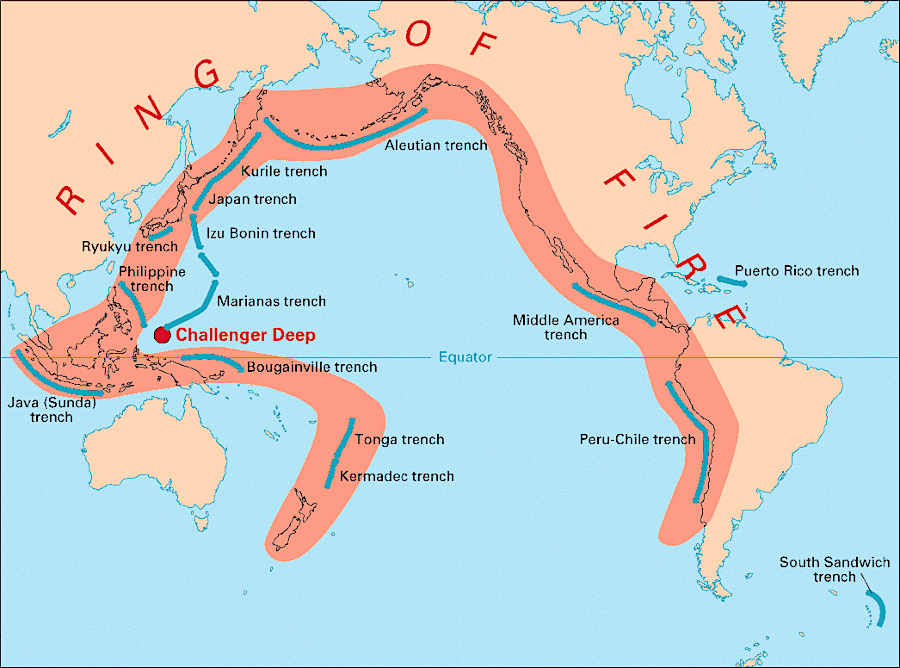
underwater and land-based volcanoes form a "Ring of Fire" where crust is being subducted on the edges of the Pacific Ocean
Source: US Geological Survey (USGS), This Dynamic Earth
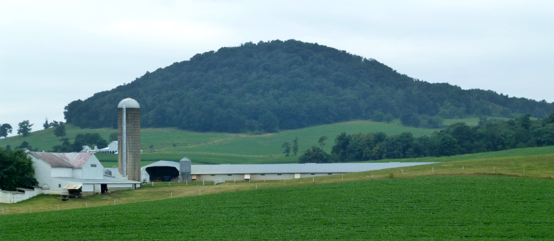
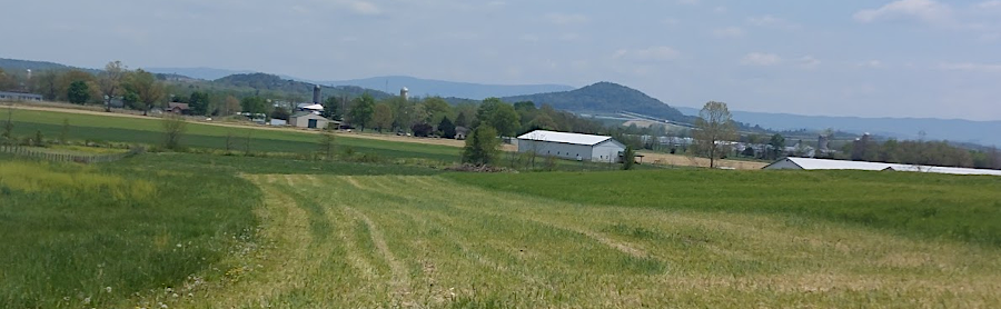
forest-covered Mole Hill, west of Harrisonburg (Rockingham County)
Source: US Geological Survey (USGS) National Map
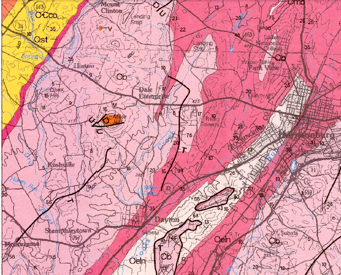
the igneous basalt at Mole Hill is surrounded by sedimentary formations of limestones, shale and sandstone
Source: Virginia Department of Mines, Minerals and Energy (DMME), Interactive Map of Virginia's Geology and Natural Resources
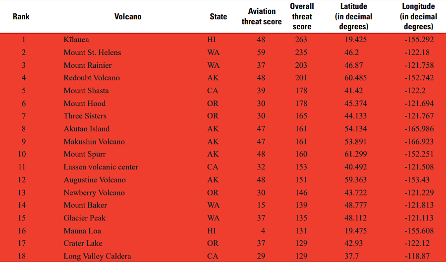
all US volcanoes ranked as "high threat" are on the Pacific Coast or Hawaii
Source: US Geological Survey (USGS), 2018 Update to the U.S. Geological Survey National Volcanic Threat Assessment (Table 2)