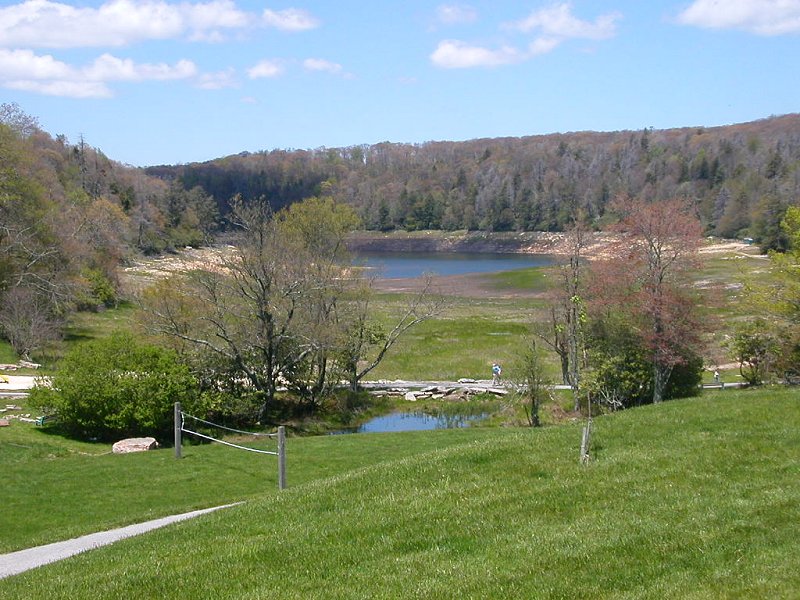
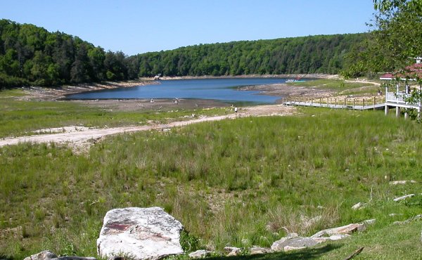
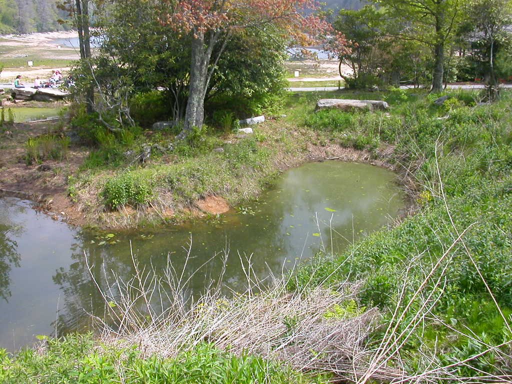
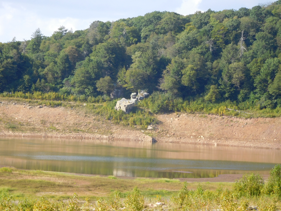
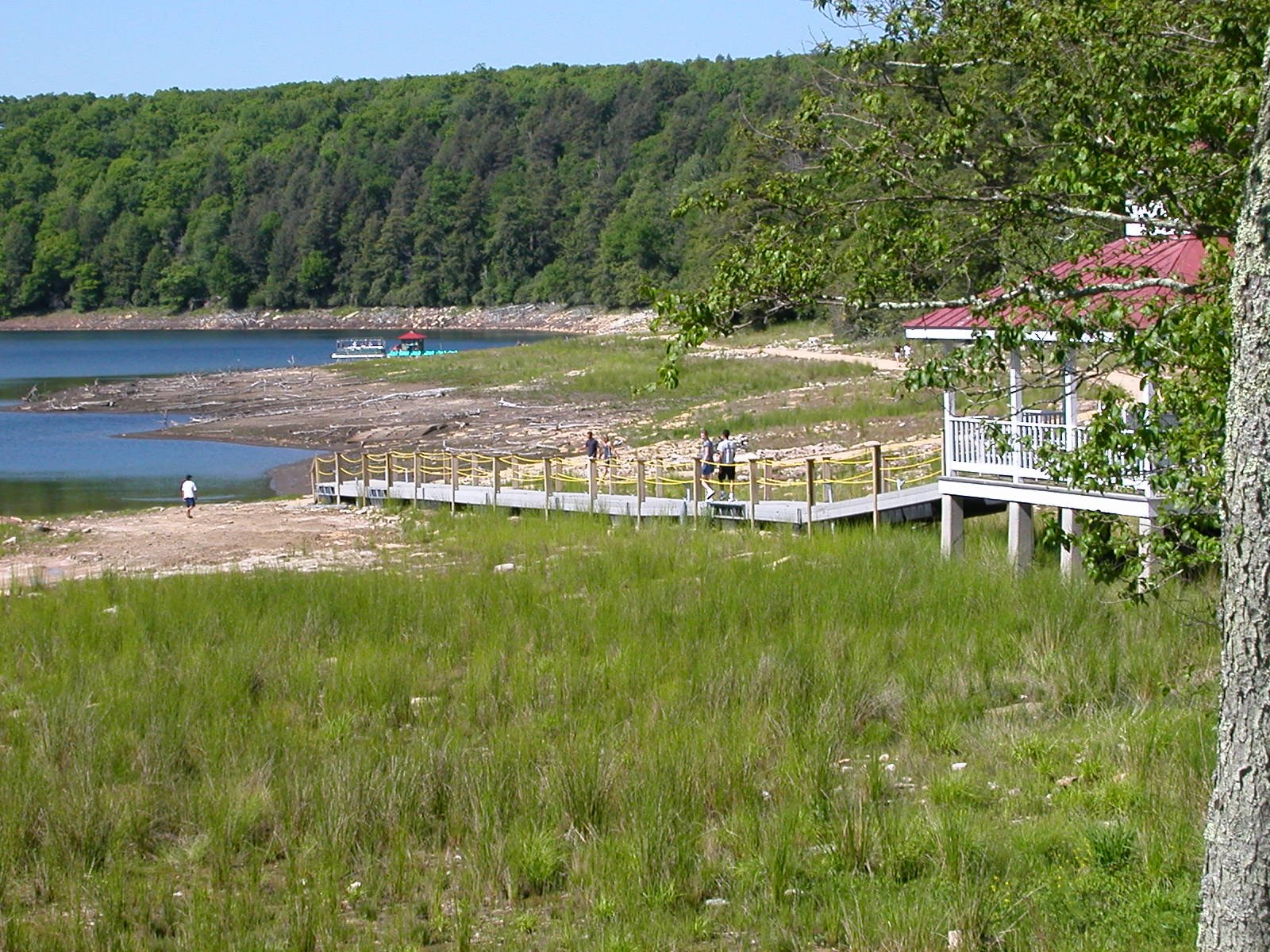
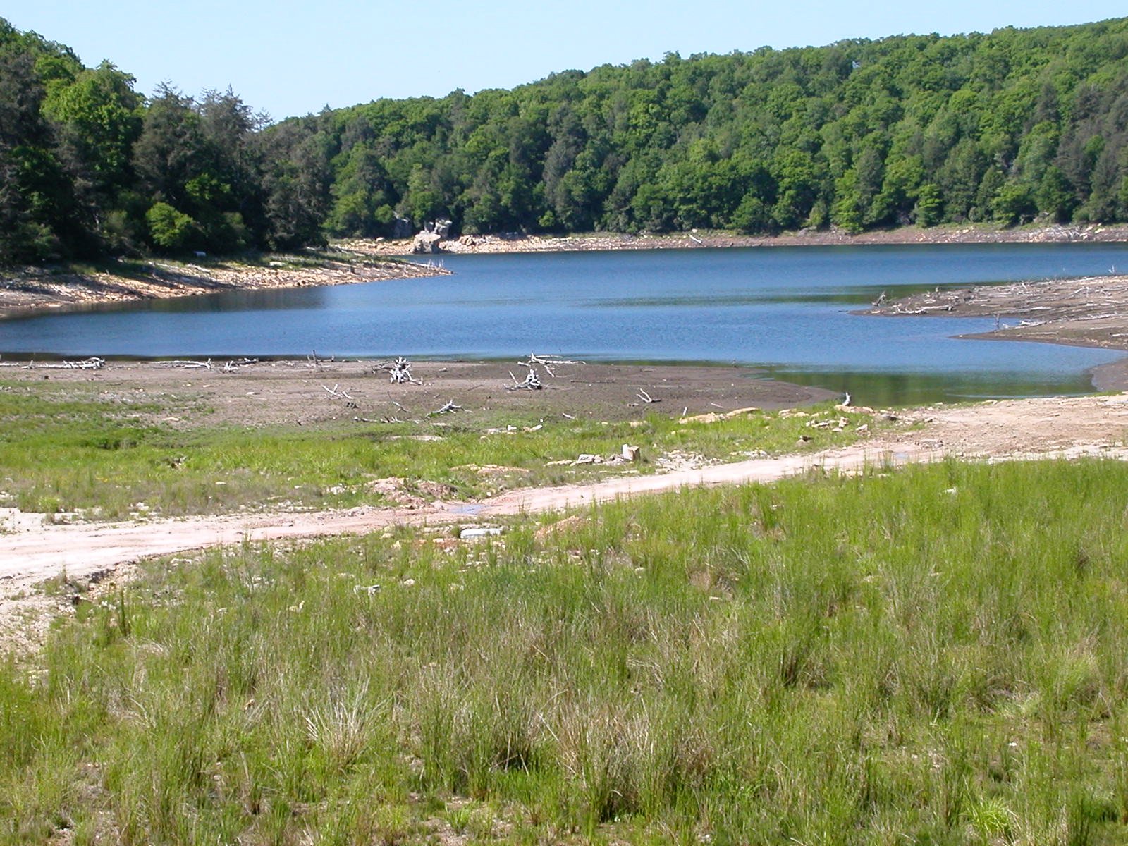
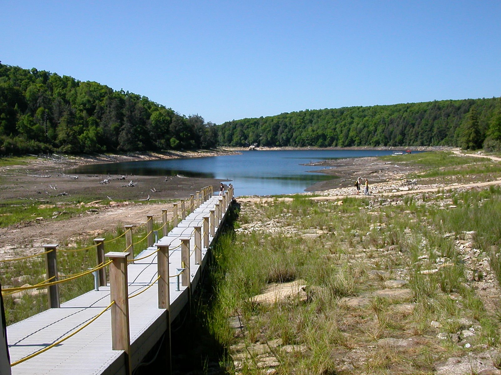
Mountain Lake in May, 2008, with constructed wetlands in foreground and disappearing lake in background
Mountain Lake in May, 2008, with constructed wetlands in foreground and disappearing lake in background
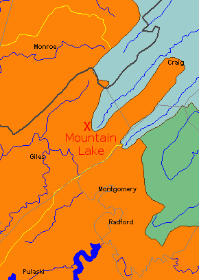
Virginia has only two natural lakes. Every other "lake" in Virginia besides Mountain Lake and Lake Drummond is a human-created reservoir. The formation of Lake Drummond is still mysterious, but geologists have finally deciphered the plumbing and origin of Mountain Lake. While less mysterious now, it's still an amazing story.
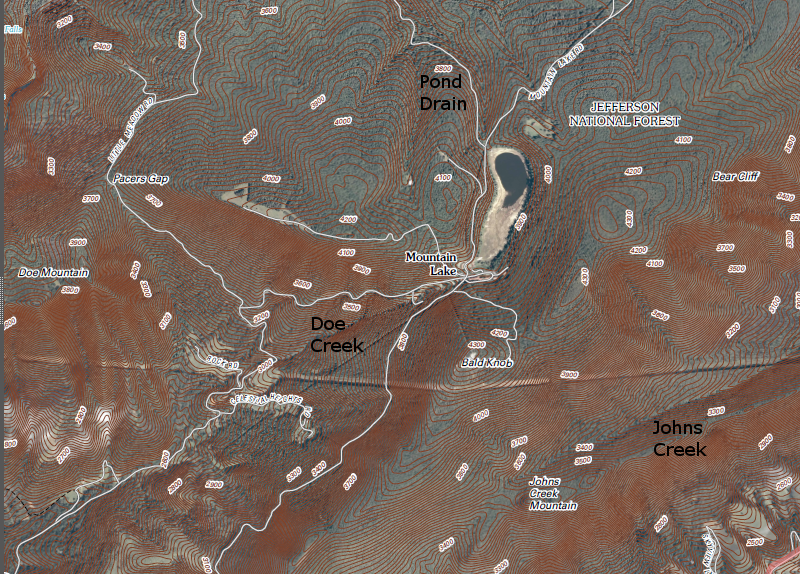
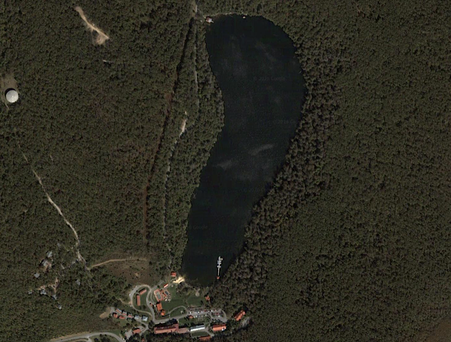
Mountain Lake is appropriately named, located at nearly 4,000 feet in elevation and over 1/2 mile long (when full). 10,000 years ago, the stream we know today as Pond Drain was at the headwaters of the Eastern Continental Divide, flowing uninterrupted towards the New River and the Gulf of Mexico. On the other side of Salt Pond Mountain, Johns Creek flowed northeast towards the James River and the Atlantic Ocean.
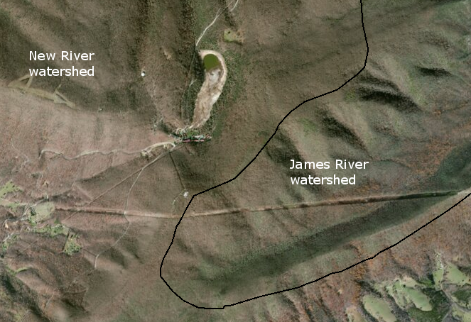
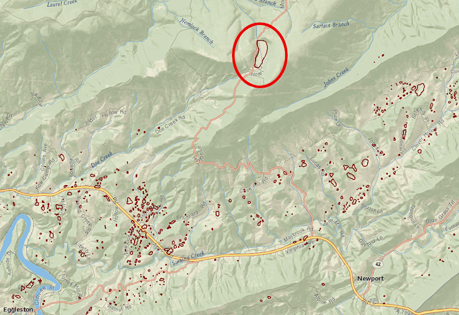
Mountain Lake is near the watershed divide between the Chesapeake Bay (James River watershed) and Gulf of Mexico (New River watershed)
Source: ESRI, ArcGIS Online (with Chesapeake Bay Watershed Boundary)
The rock layers near Mountain Lake on Salt Pond Mountain include a thin crust of Rose Hill sandstone at the top, 50-100' of Tuscarora (Clinch) sandstone below it, then a layer of Juniata sandstone/mudstone about 200' thick, with over 1500' of Reedsville-Trenton (Martinsburg) shale at the bottom. Salt Pond Mountain itself is not limestone, but there is karst topography at lower elevations in older limestone bedrock.1
The bottom of Mountain Lake is Juniata sandstone/mudstone. A contact between a purple shale layer and a white/orange sandstone layer is located below the edge of the perennial vegetation surrounding the lake. The shale crumbles easily when squeezed by hand, while the sandstone is substantially harder to crack. Within the Juniata, four "piping holes" drain water underground at the northern end. These were clearly exposed when the lake drained completely in 2008. A fifth "leak" was discovered in 2014, about 45 feet above the bottom of the lake.2
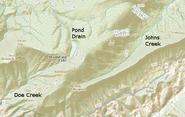
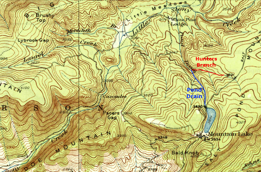
Pond Drain and Doe Creek are on the opposite side of the Eastern Continental Divide from Johns Creek
Source: US Geological Survey (USGS), National Map and National Atlas
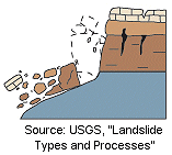 Like almost all other lakes formed naturally over millions of years in the Appalachians, the traditional assumption has been that Mountain Lake was created originally by a large rockslide. That process was proposed in 1933, and reaffirmed in 2018.
According to the landslide theory, Pond Drain eroded though the hard Tuscarora (Clinch) sandstone, then into the Juniata sandstone/mudstone. A layer of soft mudstone eroded so fast that Pond Drain may have flowed through a narrow canyon with sandstone walls on Salt Pond Mountain, and perhaps a waterfall near modern-day Newport House on the northern tip of modern-day Mountain Lake.
The overhanging sandstone ledge finally collapsed in a landslide over 6,000 years ago. Since Giles County is one of the most seismically-active areas in Virginia, an earthquake may have jiggled the rocks loose and triggered the landslide. Another possibility is that a storm comparable to Hurricane Camille in 1969 could have dropped over 30" of rain in one day, loosening the soil and triggering landslides.
The presence of an old forest growth surrounding the lake proves that no recent landslide could have created Mountain Lake in historic times. Native Americans hunting and gathering food in the area, still without the technology of pottery, bows-and-arrows, or agriculture, would have witnessed the change. Sediments at the bottom of the deep end of the lake have been dated to 6,100 years ago.3
Sandstone boulders that crashed down into the valley of Pond Drain created a highly-visible cluster near the Newport House, where the lake overflows into Pond Drain (when the lake overflows...). The sharp edges on the Tuscarora (Clinch) boulders show they have not traveled far from their source in a scarp at "Rock City," after they came down during the landslide. The boulders continue to move through slow mass wasting.4
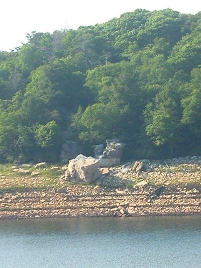
sandstone boulders with sharp edges at north end of Mountain Lake, near Pond Drain
Right after the landslide, water backed up behind the new dam of boulders and soil. The new lake may have over-topped the dam, and water may have flowed across the top of the dam on its way downstream. Today, when Mountain Lake is full, water flows over the edge into Pond Drain, on down to Little Stony Creek. It then goes over the large Cascades waterfall, past the gas station on US 460 at Pembroke, and into the New River in Giles County.
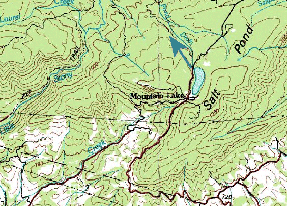
where Mountain Lake empties - in high water years - into Pond Drain
(arrow shows direction of flow towards Little Stony Creek)
Source: Microsoft Research Maps
However, the overflow into Pond Drain did *not* carve a stream channel completely down through that landslide barrier and drain the lake. On the side of Salt Pond Mountain, a lake survived and was 108 feet deep at the start of the 21st Century.
Water should have backed up behind the landslide 6,000 years ago, then flowed over the top and cut a channel 100' deep through the rock/soil debris to restore the stream channel. The watershed of the lake is only 320 acres, but with the annual 55" of rain in this area the water supply has been sufficient to cut a path through the rockslide.5
The lake should have been temporary. However, Mountain Lake is unique, and 6,000 years of erosion did not create just another valley on the slopes of the mountain.
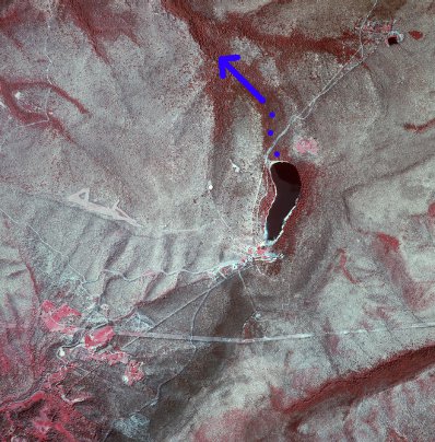
color infrared digital orthoquarterquad of Mountain Lake (when it was "full" in 2000, and showing direction of flow)
Source: Radford University GIS Spatial Data Server
There are no other natural lakes in the Southern Appalachians. Streams have eroded all other natural dams in Virginia, draining every natural lake except for Lake Drummond and Mountain Lake. Rivers chisel through the bedrock like liquid sandpaper, over time, so lakes formed in Virginia over the last 300 million years has disappeared.
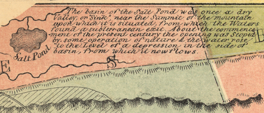
Why Pond Drain did not cut through the colluvium that slid down the mountain was once a geological mystery.
One possibility was that the Juniata sandstone/mudstone underneath Mountain Lake was cracked. That would give the water multiple exits from the lake, other than flowing over the landslide-caused dam at Pond Drain.
Another possibility was that the dam blocking Pond Drain is porous, with a series of channels through it at the bottom of the dam. Before the landslide blocked flow 6,000 years ago, Pond Drain had been a free-flowing stream. It started at the watershed divide with Doe Creek near the modern-day lodge, and flowed through a sandstone-walled canyon that may have included a waterfall. The waterfall would have been smaller than the modern Cascades downstream on Little Stoney Creek. Still, there may have been enough energy in the water to carve narrow channels into the Juniata sandstone/mudstone bedrock at the lip of the waterfall.
After the landslide, boulders could have bridged rather than filled those channels, leaving them unblocked. Water seeping through the unconsolidated sediments right after the landslide could have continued to flow through those channels, or through new paths cut through the boulders and soil that crashed down, or through cracks formed in the Juniata sandstone/mudstone lake bottom by the impact of the landslide or an earthquake that triggered the event - or through another process.
Cracks in the bedrock at the bottom of the lake could also have formed by collapse of solution channels in calcium-rich layers of the Reedsville-Trenton (Martinsburg) shale, fracturing the overlying Juniata sandstone/mudstone. The Juniata formation at Mountain Lake does not have enough carbonate itself to develop karst-like features, but cave collapse at depth in the Reedsville-Trenton (Martinsburg) shale could affect the overlying Juniata sandstone/mudstone, creating a "caprock sinkhole" that causes the water to leak out of Mountain Lake.6
Water flowing through the cracks in the bedrock, or through the landslide dam, has reduced the erosive power of the water flowing over the landslide. As a result, the dam has not been overtopped with a high-energy stream, and a channel has not been eroded into the surface of the dam despite 6,000 years of time. The energy of the water exiting the lake was diverted through four major holes etched out of the Juniata sandstone/mudstone in the lake bottom, allowing the landslide dam to withstand erosion - so far.
According to one alternative to the landslide dam theory, the Tuscarora (Clinch) sandstone blocks slumped due to freezing and thawing (gelifluction) during the last 100,000 years, but the slopes were too gentle to create a landslide. The slow "mass wasting" of the colluvium occurred too gradually to block the flow of Pond Drain and form the lake. Instead, cracks in the bedrock were the cause of the lake's formation. Pond Drain flowed through fissures into underground channels, with currents strong enough over the last 10,000 years to remove sediments and etch out the 100-foot deep basin of Mountain Lake.7
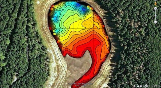
Mountain Lake bathymetric map located four "piping holes" (in blue) at northern end, presumably the outlets to underground drainage
Source: Radford University, Bathymetric map from SONAR survey conducted on Aug. 17, 2011
A landslide damming up a valley to form a natural lake is not unusual, but the continued existence of the dam is unique in Virginia now. Normally, a stream would cut a channel on the surface of the dam and drain the lake within weeks of a landslide. On Salt Pond Mountain, however, the water trapped behind the dam drained into the cracked bedrock, or into natural channels or pipes through the dam. The basin behind the dam deepened and filled with rainwater to create Mountain Lake, which at times has grown to 100 feet in depth.
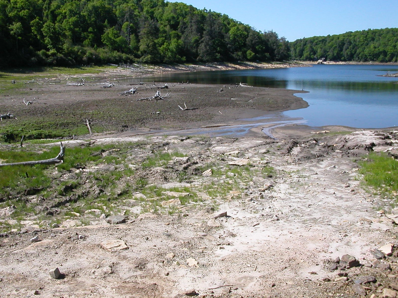
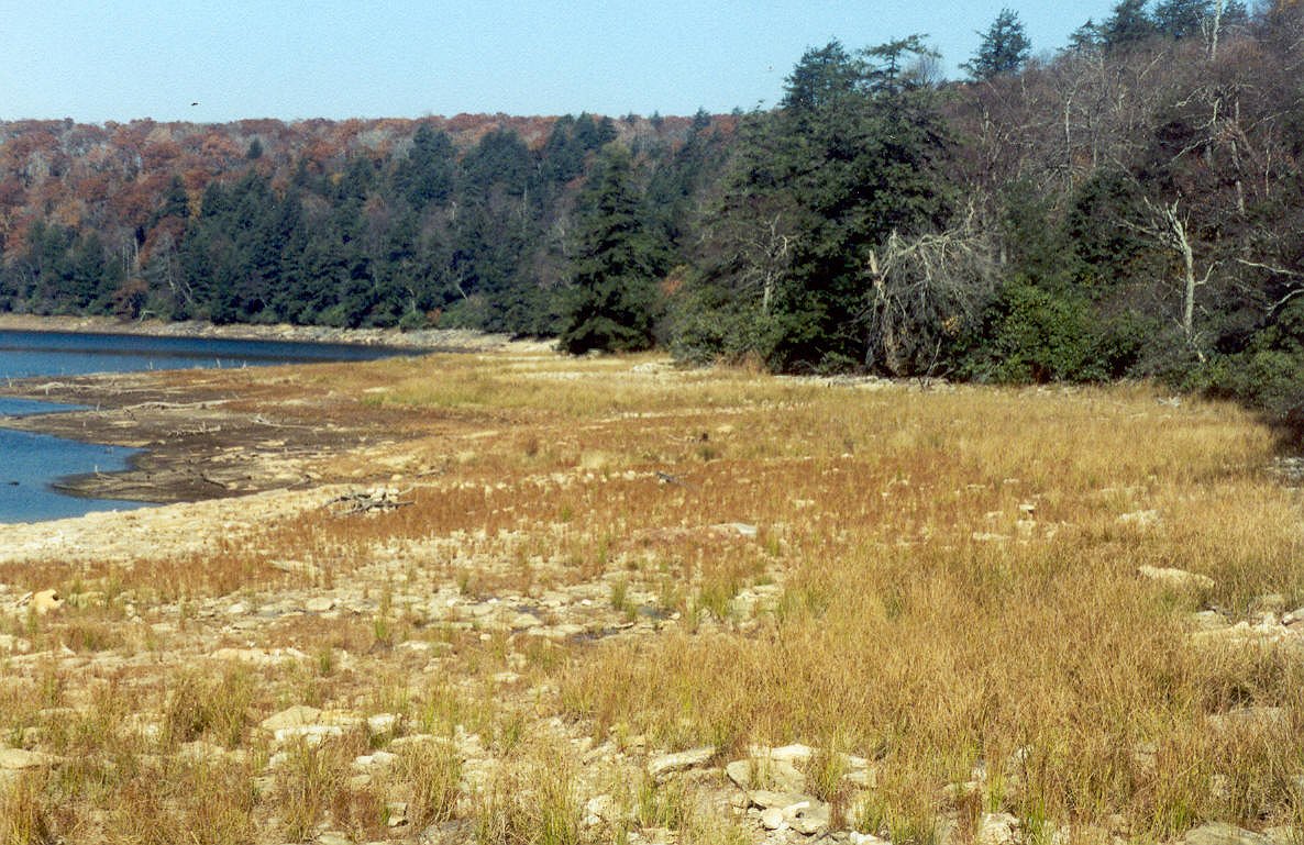
Even more unusual is that Mountain Lake completely disappears at times, leaving behind just a lake bottom that becomes a grassy meadow. Analysis of sediments reveals that at least six times, dry periods have caused the lake to dry up.
There is a cyclical pattern now, with droughts or geological changes cause lake levels to drop significantly about every 400 years. When the lake drains, sediments which had accumulated wash out through the plumbing system. That explains why the basin has not filled up and become a meadow, at the same elevation as the top of the Pond Drain landslide.
When Christopher Gist came through the area in 1751 on his way to explore lands claimed by the Ohio Company, he was the first to record the existence of the lake. He wrote in his journal, with the precision of a surveyor recording directions of travel:8
Mountain Lake, half-full
Source: US Geological Survey, Eggleston 7.5 minute topographic quadrangle (2011)
In 1768, settlers recorded just a spring in a valley with a grassy meadow. It was a good location for watering cattle and providing them salt as a dietary supplement, and the settlers named the location Salt Pond Mountain... but the "missing" lake caused the settlers to question the honesty of Gist's records of his explorations.
Analysis of the sediments at the bottom of the lake, completed for a PhD thesis published in 1999, indicated that Mountain Lake has been at very low levels or dried up to become a Sphagnum bog or dry meadow. Six times, 100, 400, 900, 1200, 1800, and 4200 years ago, the lake essentially disappeared.
In 1655 AD (plus or minus 80 years), a yellow pine grew for at least 30 years on what was later the bottom of Mountain Lake. Water levels would have been affected by changes in climate, with lower rainfalls associated with changes in the sunspot cycle, as well as by changes in water "leakage" through the landslide dam and bedrock.9
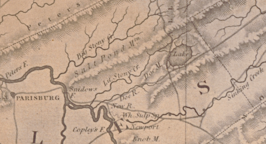
the status of Mountain Lake was recorded in 1856, as the Virginia and Tennessee brought the first railroad to Southwest Virginia
Source: Library of Congress, Map & profile of the Virginia & Tennessee Rail Road (William Willis Blackford, 1856)
Mountain Lake, as mapped in 1859
Source: Library of Congress, A map of the state of Virginia (by Lewis Von Buchholtz, L. V., Herman Böÿe, 1859)
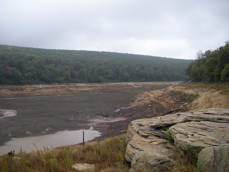
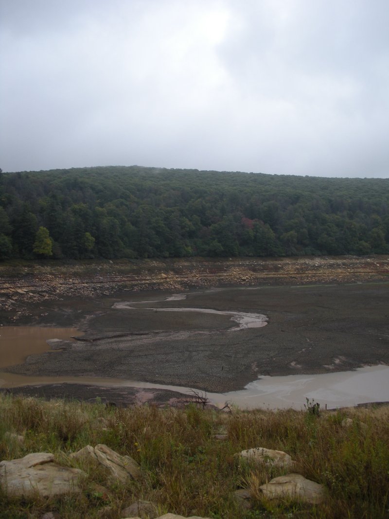
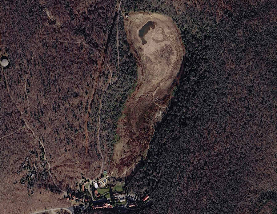
From the 1950's until more recent times, the lake has been full. From 1998-2002 the surface area shrank by half, down to 25 acres. It recovered to its normal full level in 2003, but then the cycle began again. By September 2008, the lake drained almost completely, despite above-average rainfall in the first half of 2008.
half-empty (or half-full?) Mountain Lake in June, 2002
The outlet down Pond Drain has not changed; there's no reduction and then increase in the height of the natural dam that holds water on the mountain. So... how could the lake appear and disappear so quickly?
Mountain Lake has a series of leaks, located in the crack which caused the basin to develop in the first place. Normal "leakage" through the natural holes in the bottom of Mountain Lake is 43 liters/second (roughly 700 gallons per minute).10
Source: Mountain Lake Lodge, Mystery of the Lake
When silt plugs the hole, rainfall exceeds the loss of water through evaporation/leakage and the lake level rises. Once the lake reaches the level of the outlet to Pond Drain, any excess inflow from rain and springs will just flow down to the New River. In drought years, the outflow may be reduced - but drought alone does not explain the lake's dramatic and intermittent shrinkage.
Silt and leaf litter is continually washing into Mountain Lake, but occasional earthquakes help the water draining through the natural crevices at the lake bottom erode away the silt plug. There is still a layer of gooey silt at the bottom as the lake drains, but at times the goo is not watertight. When the cracks at the bottom are open wider, drainage exceeds the inflow. More lake water flows underground into the water table, and the surface level of Mountain Lake drops. Occasionally, the lake dries up completely - as occurred in 2008, and apparently between 1751-1768.
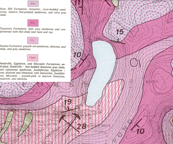
sandstone/shale geologic formations around Mountain Lake (names of formations have been refined since 1986)
Source: Virginia Department of Mines, Minerals and Energy 1986 Geologic Map of Giles County, Virginia (Publication 069)
After the lake drains, presumably one of the constant minor earthquakes in Giles County is required to adjust the way silt seals up the cracks at the bottom. A quake may realign the rocks so the natural silt can seal the crevices between them again, and the lake re-fills again.
In 1959, one quake cracked the mantle above the fireplace in the Mountain Lake Hotel, and the lake re-filled soon afterwards. Since it appears the water in the lake drains out within less than 2 years, the lake levels can change rapidly. Any increase in the porosity of the holes at the bottom could trigger rapid decline in the lake levels - as demonstrated in 2008, when the half-full lake completely disappeared in about 6 months.
On September 20, 2008, the skeleton of Samuel Ira "Si" Felder was discovered in the exposed sediments of Mountain Lake. He had fallen out of a boat in 1921, and his body was not recovered until the lake drained 87 years later. His great-niece had his remains buried in the South Carolina cemetery next to his wide. The great-niece also had the gravestone updated. It had been inscribed with "Drowned - Body Never Recovered," but a line was drawn through the "Never" and "September 20, 2008" was added.11
dye from Mountain Lake may have been recovered near confluence of Hunters Branch and Pond Drain
Source: US Geological Survey, Pearisburg 15x15 topographic quad (1937)
Still remaining to be discovered: where the water goes, once it leaks out of Mountain Lake.
In January, 2012, one pound of fluorescein dye was placed into each of the four piping holes (after cutting though the ice on top of the frozen remnant of Mountain Lake). By April, 2013, there was still no solid recovery of the dye in the various streams nearby. The most likely candidate for a "receiving stream" was Pond Drain, and some evidence of dye was recovered at the confluence with Hunters Branch. When Mountain Lake is full and overflows, the surface water goes over the lip near Newport House and down Pond Drain to Little Stony Creek.
However, the dye trace experiment did not determine conclusively if Mountain Lake's "leak" also ends up in Pond Drain. Bedrock beneath the lake may be capturing the dye-filled water, then releasing it much later.12
Subsurface drainage could ignore the topographic divides at the surface; there is no evidence yet that Mountain Lake's water really doe flow over Cascades waterfall on Little Stony Creek. The dye may still be coursing through the underground conduits before emerging at a spring - but is still unclear which springs, in which stream drainage(s), are fed by Mountain Lake. If the piping holes are connected to carbonates in the Reedsville-Trenton (Martinsburg) shale, then the roughly 700 gallons per minute leaking into the bedrock could be diffusing though an extensive network of underground fractures rather than flowing to just one or two outlets.
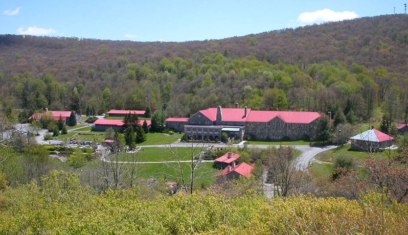
Mountain Lake Hotel complex in May, 2008
Henry Chapman purchased the land around Mountain Lake in 1829 and started offering lodging to travelers. General Herman Haupt purchased it in 1851. Construction of the Mountain Lake and Salt Sulfur Springs Turnpike Company, chartered in 1856, helped bring more tourists travelling between Yellow Sulfur Springs and Salt Sulfur Springs. The founder of the American Hotel Company, William Lewis Moody Jr., acquired it during the Great Depression.
Mountain Lake and the land around it are still privately owned. The owners, the Mary Moody Northen Endowment, have been particularly sensitive to the natural systems in the area. The restaurants and overnight facilities (lodge/cabins) are operated to generate funding for the foundation, but revenue generation is not the only management objective. The landowners in the drainage area of Mountain Lake manage much of their privately-owned 2,600 acres as wilderness, creating the Mountain Lake Conservancy to oversee activities outside the developed area.
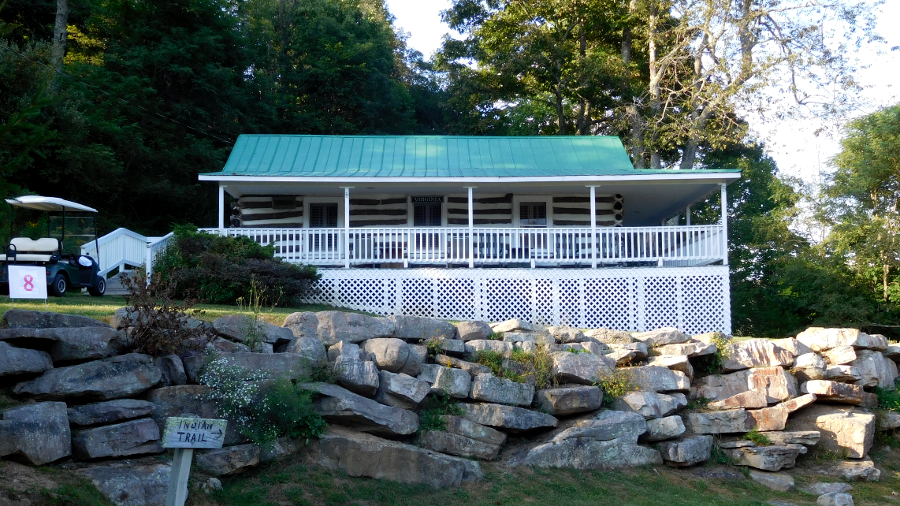
rental cabins at the Mountain Lake resort generate income for the Mary Moody Northen Endowment
In particular, the private landowner has sought to minimize lake pollution. Mountain Lake has been especially clear because the soils are low in calcium, natural sources of nitrogen and phosphorous are limited, and there are few sources of nutrients from human development (in contrast to the Chesapeake Bay). Extra algae in the lake would reduce the clarity and beauty of the view.
However, man-made sources recently threatened to shift the ecology of Mountain Lake from nutrient-poor to nutrient-rich. Scientists warned in 1994 that excessive amounts of phosphate and nitrate had caused the lake to shift from oligotrophic in 1985 towards eutrophic status, with new algae species and even a "dead zone" of anoxic bottom water. By 1998, however, phosphate levels had dropped back to those measured in the early-1980's, most nutrients entering the lake again came from rainwater, and the trend towards eutrophication had stopped.13
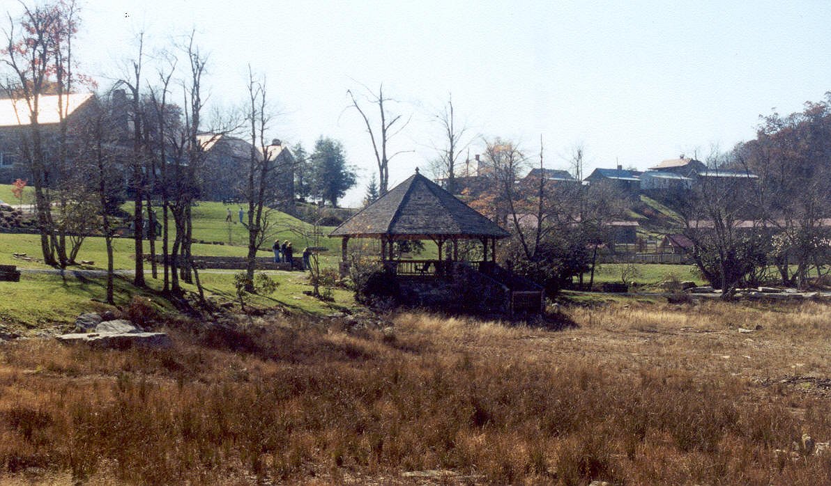
To maintain both the vista and recreational facilities on the edge of the lake, the private owners have constructed artificial wetlands between the lawn in front of the lodge and the lake. The wetlands intercept fertilizer and pesticides used to maintain the grass and shrubs. Plants in the wetlands absorb the excess nutrients, and cleaner water is discharged into Mountain Lake.
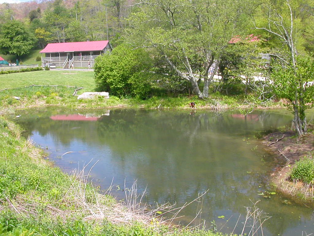
constructed wetlands downhill between lodge and lake
In addition, wastewater produced in the cabins and lodge rooms is treated and sprayed onto the forest soil into a different watershed, so surface runoff would not reach Mountain Lake. On the surface, bacteria and plant roots should absorb nutrients in the soil. In major storms, whatever material might wash downhill should end up flowing towards Pond Drain or Little Stoney Creek, downstream of Mountain Lake.
Water trapped in the stormwater basins created to intercept nutrients in the runoff from the lodge and lawn area apparently does not seep underground and flow to Mountain Lake, even though the basins were constructed on the water's edge. That water appears to be diverted through underground channels to Pond Drain or Little Stoney Creek, rather than seep as groundwater into Mountain Lake. The water budget of the lake was altered unexpectedly, and recharge diminished.14
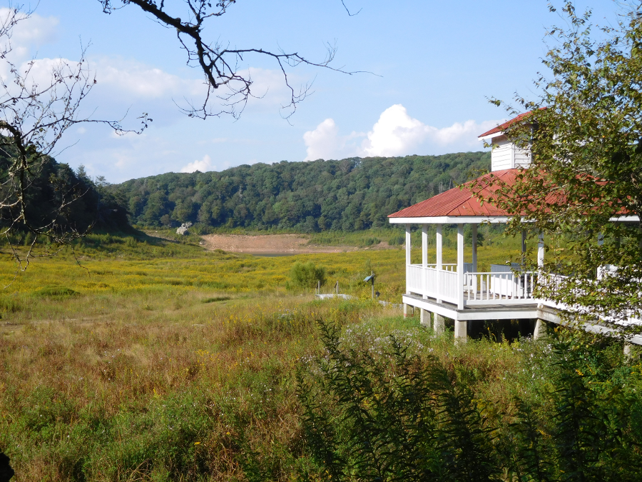
the lawn in front of the hotel provides a scenic vista, even without the lake (as seen in September, 2016)
The disappearance of the lake is more than a geologic detective story; it has economic consequences. The owners have been protecting the lake, only to see their investment in conservation literally disappear.
Tourism at the lodge has depended in part upon the clear blue water in the lake. Visitors used to spend more than one week on family vacations, since there were so many recreational opportunities involving boating and swimming. Loss of the lake, with its active recreation opportunities and scenic vistas, reduced revenues at the resort substantially. After the lake dried up in 2008, average occupancy dropped from 60% to 30%.15
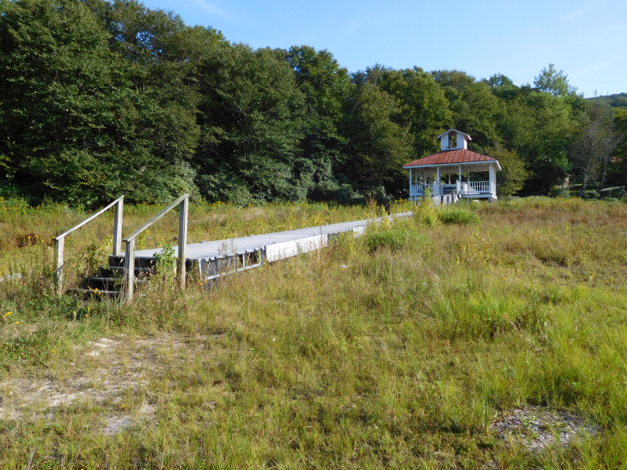
Mountain Lake gazebo with ramp to boats was high and dry on September 9, 2016
In the drought of 2002, the lake's owners considered supplementing the natural supply of water by pumping groundwater from a well into the lake.16
In 2008, the owners tried to plug the holes with sandbags. On July 28, "An audacious project to stuff sandbags into the eighteen or so known holes in the bottom were cancelled due to zero visibility just 15 feet beneath the surface."17
As the lake drained in the summer of 2008, business dropped by 20% at the Mountain Lake Resort. One concern of Mountain Lake management: at least once in the six times the lake has dried up in the last 4,500 years, it stayed dry for decades.18
by 2016, trees were beginning to grow in the bed of Mountain Lake due to natural plant succession
Without the lake, efforts to increase revenue included highlighting Hollywood history at the site. Mountain Lake and the old stone hotel were featured (especially in the first 15 minutes) of the 1987 movie "Dirty Dancing."
The movie described events at the fictional Kellerman's Resort in the Catskills, but the producers needed outdoor shots set in late summer. When the leaves at Mountain Lake began to turn color in September, 1986, the cast and crew went further south.
As a result, Lake Lure in North Carolina got to claim its 15 minutes of fame for imitating a New York resort. That shift in location has provided a excuse for "Dirty Dancing"-themed events at both locations.19
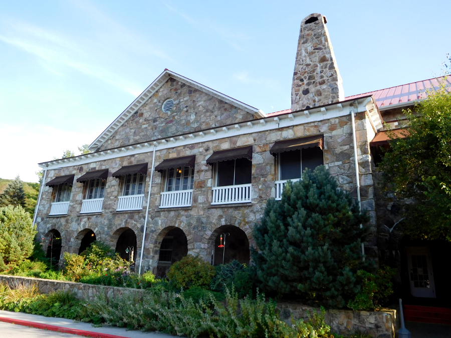
Mountain Lake hotel or "lodge"
After the Mountain Lake Hotel closed for the season in November 2012, the owners of the resort initiated a $2.5 million dollar makeover to restore its allure as a vacation destination. The Mary Moody Northen Endowment upgraded the rooms, revised restaurants, expanded outdoor recreation facilities such as zip lines, and tore down structures that no longer met the building code. To highlight the changes, the resort was retitled Mountain Lake Lodge (vs. "hotel").20
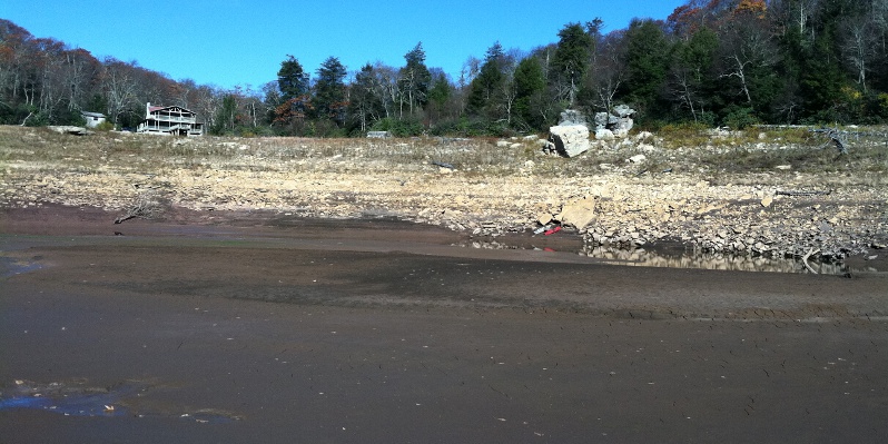
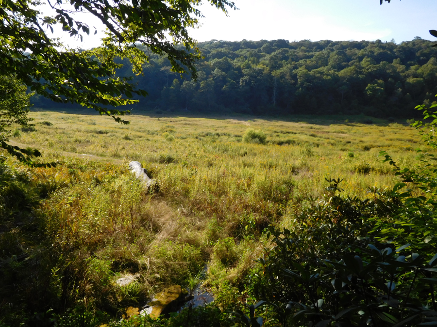
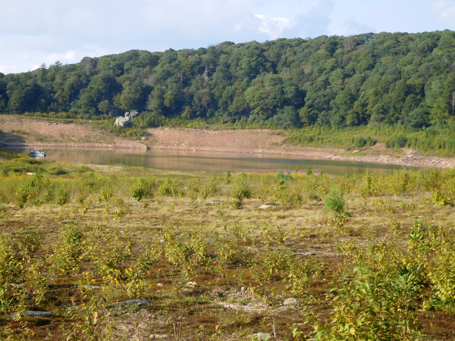
exposed muddy bottom with water remaining only in deepest portion of Mountain Lake, October 2011
In addition to the cosmetic makeover and facility upgrades, the four piping holes in the bottom of the lake were plugged in 2013.
Despite the cold weather and snow in February, 2013, contractors with heavy construction equipment moved dirt and rocks from the colluvium on the lake edges, dumping the material directly into the holes. Using local material would mimic the natural process of siltation, but bentonite was added and heavy equipment used to accelerate the process dramatically.
There had also been discussions about sealing the lake bottom with asphalt pavement and concrete. Paving the bottom would have made Mountain Lake more like a swimming pool, and damaged its reputation as a natural lake.
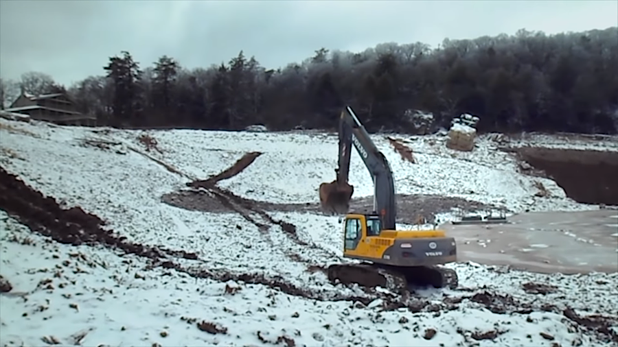
Mountain Lake's four natural piping holes were artificially plugged in 2013
Source: Mountain Lake Lodge, The Mystery of the Lake
The Virginia Marine Resources Commission did not assert any authority to oversee the plugging of the holes in 2013. That state agency claims responsibility for most land underneath non-tidal river beds, but apparently not for the land submerged beneath Virginia's two natural lakes. The US Army Corps of Engineers and the Virginia Department of Environmental Quality may have responsibilities under the Clean Water Act to authorize the dredging and filling of the holes underneath the remaining portion of Mountain Lake in 2013, but both agencies allowed the bottom of Mountain Lake to be altered without interfering.
The Virginia Department of Historic Resources also chose not to get involved during the removal of artifacts at the bottom of Mountain Lake in 2008. The only government agency who opened a case file was the Giles County Sheriff's Office, which dealt with the identification of the body for two years.21
By the end of 2013, the lake size had doubled. Engineering geologists at Radford University anticipated that if the plugs were successful, Mountain Lake could return to full pool in less than two years.22
That did not happen after the holes in the lake bottom were plugged.
In June, 2016, an inquiry on Facebook asked "Does the lake have water?" The response was "It does but it is still working on getting to a full level."23
In 2020, the water level began to rise up again. By July, Mountain Lake was 1/3 full again, but the geologists using new Light Detection and Ranging data (LiDAR) data finally understood why the lake was not refilling fast.
The dam was porous at multiple levels. As the water level rose, leakage continued through the dam after the four major "piping holes" in the lake bottom were plugged. The landslide which created the dam brought down large sandstone blocks and enough dirt and other material to be watertight, but at times new holes develop in the dam's colluvium. Water can leak out between the rocks, or through cracks in the rocks, when smaller materials are washed away.
A major factor in the lower lake level was discovered to be diversion of runoff from Blueberry Ridge. Construction of cabins and homes there since 1994 had to comply with Virginia's stormwater management regulations. The runoff from that watershed reaching Mountain Lake was reduced by 45%, limiting its recharge rate.
The current leaks in the dam are draining Mountain Lake almost as fast as the reduced flow of water reaches the lake. Water level will rise only if silt, leaves, or other material clogs the natural cracks in the colluvium again. That could happen if a minor earthquake jiggles the colluvium, and Mountain Lake could grow back to cover 50 acres again.
There was a possibility that climate change would result in more storms and greater precipitation at Mountain Lake, but there was also the risk that the changing weather patterns would bring less rainfall to the watershed.24
Mountain Lake can be considered as a unique sinkhole in a sandstone landscape, along with sinkholes in limestone (brown lines)
Source: Virginia Department of Conservation and Recreation, Virginia Natural Heritage Data Explorer
Question: Why isn't there a "Mountain Bog" instead of a "Mountain Lake"? Why hasn't the lake bottom become filled with organic material over the last 6,000 years as needles, leaves, branches, and soil in the small watershed above Mountain Lake have washed down into the lake?
Answer: Because the underground cracks have been wide enough and currents fast enough to carry away sediment, organic material and silt has not plugged the piping holes. If for some reason the hole at the bottom of the lake were to be sealed completely, then sediments would accumulate and Mountain Lake would gradually become a bog (or carve a deeper channel through the Pond Drain outlet).
Soil would develop in the bog, as bedrock decayed and organic nutrients were deposited each Fall. Over time, the lake bottom would fill up, reducing the volume of water. Trees would grow in the soil, and a forest would replace the bog. That's what has happened to the very small depressions in the Virginia mountains that did not have enough water to carve a discharge outlet, draining their water to the Atlantic Ocean/Gulf of Mexico.
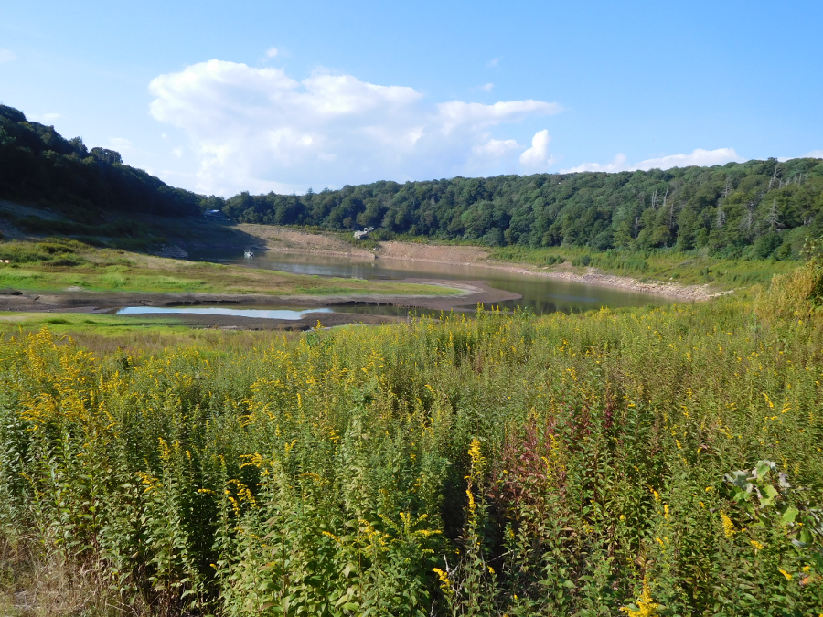
Mountain Lake - September 9, 2016
Mountain Lake is unique in Virginia, but not the world. There are other lakes which disappear and re-appear.
In Florida, Lake Jackson is normally 4,000-acres wide and 10-15' deep. On an irregular basis, but roughly every 20 years, the weight of the water will push through the thin clay layer of the lakebed and connect to the porous limestone bedrock.
Water drains through a sinkhole, typically Lime Sink on the northern side of the lake or Porter Hole Sink n the southern side. The lakebed is completely exposed. Sediments washing into the lake plug the hole, water rises again, and the lake attracts wildlife and supports aquatic plants - until another wet year, when the cycle starts again.
At least three people have died in catastrophic collapse of sinkholes in Florida's karst. The Florida Speleological Society had described the state as "Swiss cheese coated with soil." The 285-acre Scott Lake near Lakeland, Florida, has also drained and refilled, a process described by a local geologist as:25
Loughareema in Northern Ireland is another ephemeral lake. It intermittently will drain, in less than a week, into an underground drainage system during dry periods. Refilling can also be rapid, if a storm brings heavy rainfall. The "Vanishing Lake" has a peat bottom above a layer of chalk, and leaks in the peat coating trigger the draining events.26
Lake Cachet 2 in Chile has disappeared several times. It is a meltwater lake trapped by the Colonia Glacier in the Andes. The glacier is thinning, and water in the lake has been able to buoy part of the glacier and carve a tunnel through the ice wall and empty the lake. After draining, the tunnel collapses and the lake refills several times a year. People living downstream have mastered procedures for evacuating the valley where they live.
Unlike the repeated draining and refilling of Lake Jackson in Florida for centuries, Lake Cachet 2 probably has a short lifespan. As the climate changes, the retreat of the glacier will ultimately move the ice dam and then eliminate the glacier in Patagonia.27
Mountain Lake in September, 2016 (click on images for larger versions)


Mountain Lake in September, 2008 (click on images for larger versions)
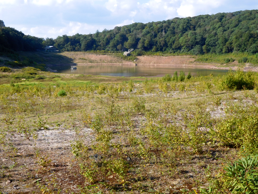
Mountain Lake in June, 2002 (click on images for larger versions)

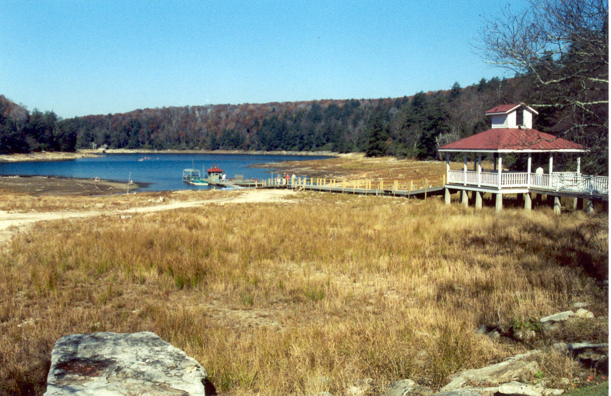
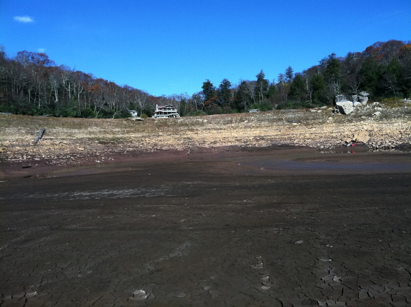
Mountain Lake on October 20, 2001 (click on images for larger versions)
Mountain Lake in 2003 vs. 2025
Source: ESRI,
Mountain Lake drains into Little Stony Creek, then water flows to the New River, Ohio River, Mississippi River, and ultimately the Gulf of Mexico
Source: Library of Congress, A map of the state of Virginia, constructed in conformity to law from the late surveys authorized by the legislature and other original and authentic documents (1859)
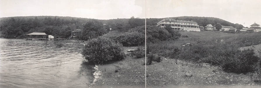
wooden hotel at Mountain Lake in 1914, before current stone structure was built
Source: Library of Congress, Mountain Lake, Va.
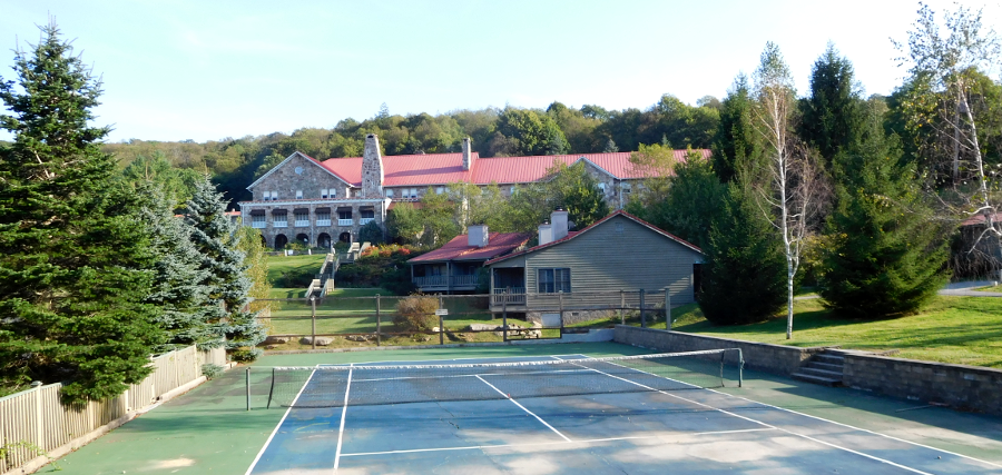
the current Mountain Lake complex offers rooms in the lodge and rental cabins, tennis, volleyball, a pool, and outdoor activities
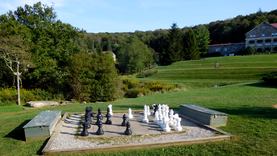
since Mountain Lake became too small for most recreational use, the resort has emphasized other activities