The boundary between Virginia and Maryland was established by multiple colonial charters, two negotiated settlements by the states in 1785 and 1958, an arbitrated agreement in 1877, and several Supreme Court decisions. The details of the Potomac River boundary line, and the boundary on the Eastern Shore separating Accomack County in Virginia from Worcester/Somerset counties in Maryland, were not defined easily.
The Potomac River divides Maryland and Virginia, but Virginia does not own half of the Potomac River. The Maryland-Virginia boundary is next to the Virginia shoreline at the low-water mark in most places; the line separating Maryland from Virginia is not in the middle of the river.
As a result of this peculiar boundary:
- in the 1950's, when gambling and liquor-by-the-drink were legal in Maryland but not Virginia, Colonial Beach and Prince William County had slot machines located on boats docked in the river off the Virginia shoreline. (Customers would park in Virginia, walk out a pier, and "step across the line" into Maryland.)
- today, if you want to get married on a boat in the middle of the Potomac River while looking at Mount Vernon, you need a Maryland marriage license.
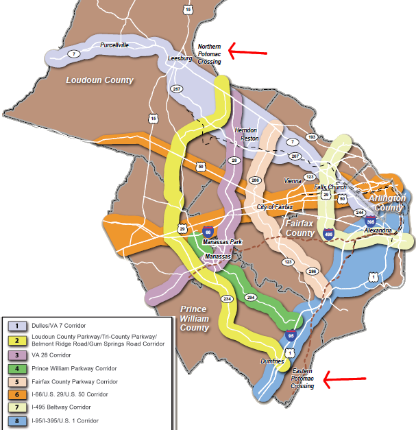
- bridges crossing the Potomac River are almost completely in Maryland... and the dreams of Virginia transportation planners to build new bridges across the Potomac River in Loudoun/Prince William counties can be blocked by Maryland, which has expressed clear opposition to road projects that would extend urban sprawl further into Montgomery/Charles counties.
proposed bridges across the Potomac River will require Maryland's consent
Source: Northern Virginia Transportation Authority, TransAction 2040 Summary Map
Three charters issued by James I between 1606-1612 included most of what is now Maryland within the boundaries of the Virginia colony. After James I revoked Virginia's charter in 1624 and converted it into a royal colony, there were no constraints on how the king could alter the boundaries of Virginia.
In 1632, King Charles I granted a charter to Cecil Calvert, Baron of Baltimore, and reduced the size of Virginia. The king gave to the Calverts the land south of the south of the 40° ° line of latitude to the Potomac River. That grant included the northern part of the Delmarva Peninsula and the top of the Chesapeake Bay, plus all of the Potomac River.
The Calverts named their new colony after the wife of Charles I, Queen Henrietta Maria. An earlier colony founded by George Calvert on the island of Newfoundland was called Avalon, but Maryland provided some political advantage by honoring the king's wife. Virginia colonists had sought royal favor in the same way, naming their colony after the "virgin queen" Elizabeth and naming the first town after James I.
The original plan of Charles I had been to reward Cecil Calvert's father George. George Calvert had considered asking the king for land between the James and Chowan rivers, picking off the southern end of the Virginia colony. The area was not "unoccupied," but land claims by Native Americans were not a factor in drawing the boundaries of English colonial charters.
Virginia officials, and others in England who hoped to obtain their own grant for the Carolinas, steered Calvert and King Charles' officials into choosing land far to the north of the Virginia settlements on the James River. Encouraging Calvert's Catholic settlers to occupy the uncolonized land north of the Potomac River would help England compete with the Dutch, who were starting to settle in the gap between New England and Virginia.1
George Calvert anticipated getting the entire Delmarva Peninsula in his grant. However, he died before the paperwork was finalized, and royal officials realized that Virginia colonists had already settled in what today are Accomack and Northampton counties.
Delmarva Peninsula, without political boundaries later imposed by English officials
Source: US Fish and Wildlife Service, Wetlands Mapper
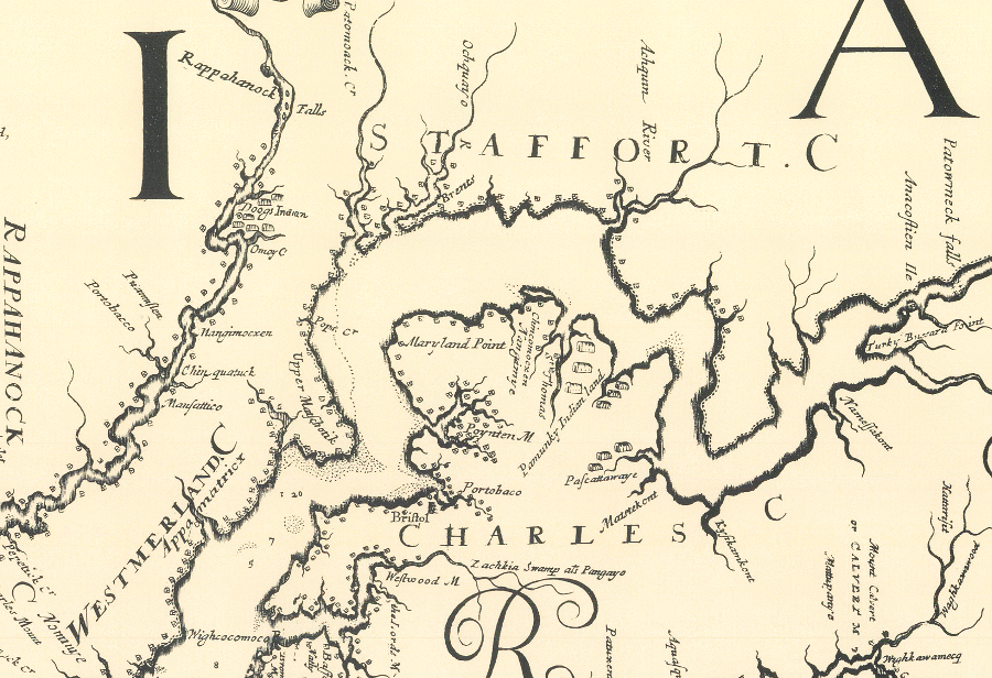
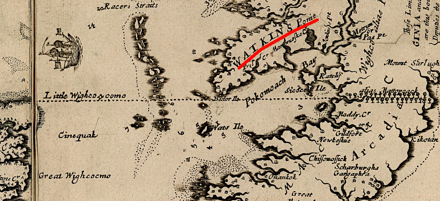
When George's son Cecil Calvert got his charter for Maryland, the southern part of the Eastern Shore was excluded and remained within the Virginia colony's boundaries. The 1632 Maryland charter defined the new colony's southern boundary on the Eastern Shore:2
by a Right Line drawn from the Promontory, or Head-Land, called Watkin's Point, situate upon the Bay aforesaid, near the river Wigloo, on the West, unto the main Ocean on the East
the 1632 Maryland charter defined the new colony's southern boundary on the Eastern Shore as a straight line from Watkin's Point to the Atlantic Ocean (NOTE: map is oriented with West at the top, and North to the right)
Source: Library of Congress, Virginia / discovered and discribed by Captayn John Smith, 1606
The northern boundary of the new colony of Maryland was defined by drawing a line due west from the ocean along the 40 degree parallel, the southern boundary of the New England grants, until getting to a point due north of the beginning of the Potomac River.
In reality, the 40 degree parallel was located further north where Philadelphia is now located, creating an overlapping claim to land after William Penn was granted a charter for a new colony in 1681. Maryland and Pennsylvania argued about their border until the Mason-Dixon Line was surveyed in 1767 by Charles Mason and Jeremiah Dixon.
John Smith's map indicated that the 40th parallel of latitude was at the northern tip of the Chesapeake Bay
(NOTE: map is oriented with West at the top, and North is to the right)
Map Source: Library of Congress, Virginia / discovered and discribed by Captayn John Smith, 1606
The western boundary of Maryland was based on the location where the Potomac River started, along a line running directly south from the 40th parallel (at least that's what they thought in 1632...) to the spring at the headwaters of the Potomac River. The Deakins Line was surveyed in 1788, starting at the sandstone monument (the "Fairfax Stone") that had been erected in 1746 and moving north to the Pennsylvania-Maryland line.
In 1910, the US Supreme Court ruled in in Maryland v. West Virginia that the Deakins line would remain the boundary. Virginia and Mayland had agreed in 1852 to resurvey the line, and Lieutenant Nathaniel Michler of the United States Topographical Engineers completed a more-accurate survey in 1859. He set 20 monuments to mark the proposed new Virginia-Maryland boundary. When Michler reached the Mason-Dixon Line, his surveyed meridian line was about one-half mile further west of the intersection of the Deakins Line with the Mason-Dixon Line. About nine square miles would become part of Maryland rather than Virginia, if both states accepted the more-accurate 1859 Michler Line to replace the 1788 Deakins Line.
The Civil War prevented any effort of Maryland and Virginia to deal with their boundary issue. After 1863, refining the location of the boundary required Maryland and the new state of West Virginia to reach agreement. West Virginia declined to transfer nine square miles of territory to Maryland, and Maryland filed suit in the US Supreme Court in 1891 to force resolution.
Maryland hired William McCulloh Brown and Louis Agricola Bauer to survey a new boundary. Rather than start at the Fairfax Stone, they defined a different tributary as the source of the North Branch of the Potomac River. Brown and Bauer started surveying north from a point 1.25 miles to the northwest of the Fairfax Stone. They placed a new "Potomac Stone" at their starting point, claiming it was the true southwest corner of Maryland.
The Potomac Line surveyed by Brown and Bauer intercepted the Mason-Dixon Line over a mile further west than the location defined by Lieutenant Nathaniel Michler as the northwest corner of Maryland. West Virginia officials rejected the attempt by Maryland to expand even more, at West Virginia's expense.
In 1910, the US Supreme Court affirmed the Deakins Line as the West Virginia-Mayland boundary, because so many land titles and county charters had used that historical survey. In 1912, a new survey to retrace the Deakins Line was completed by Julius Monroe, Samuel Gannett, and William McCulloh Brown. Brown represented Maryland, Monroe represented West Virginia, and the court chose Gannett as a neutral professional.
The surveyors rebuilt the Fairfax Stone and moved north. Over the 35 miles to the Mason-Dixon Line, they set 65 monuments to mark their retracement of the 1788 Deakins Line. They also made four adjustments to keep parcels of property intact within just one state.
Choosing three rather than two surveyors turned out to be a wise decision. Brown refused to concur with the survey, but there was a 2-1 majority for support of the final product. Monroe and Gannett met the Mason-Dixon Line about one-half mile east of Michler's intersection, preserving West Virginia's territory.3
As defined in the 1632 charter, the Maryland boundary crossed the river to the southern bank. Key language in the grant from Charles I was that Maryland's western boundary kept going south and crossed the Potomac River to its southern shore, before following the southern edge of the Potomac River to the Chesapeake Bay. The western boundary extended:3
in original Latin: ad ulteriorem dicti Fluminis Ripam et eam sequendo qua Plaga occidentalis ad Meridionalem spectat usque ad Locum quendam appellatum Cinquack
in English: unto the further Bank of the said River, and following the same on the West and South, unto a certain Place, called Cinquack, situate near the mouth of the said River.
Maryland's border was defined in 1632 charter by a line running south from 40th parallel (supposedly...) to the start of the Potomac River, then unto the further Bank of the said River before following the southern edge of the Potomac River to the Chesapeake Bay
Map Source: US Fish and Wildlife Service, Wetlands Mapper
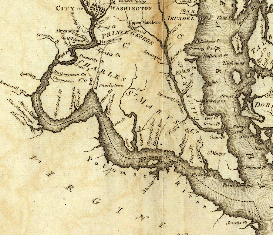
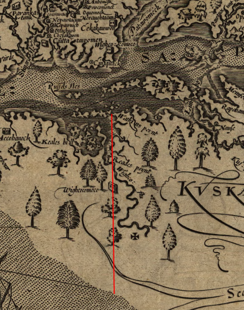
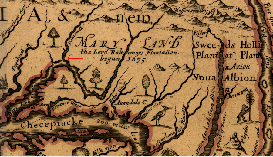
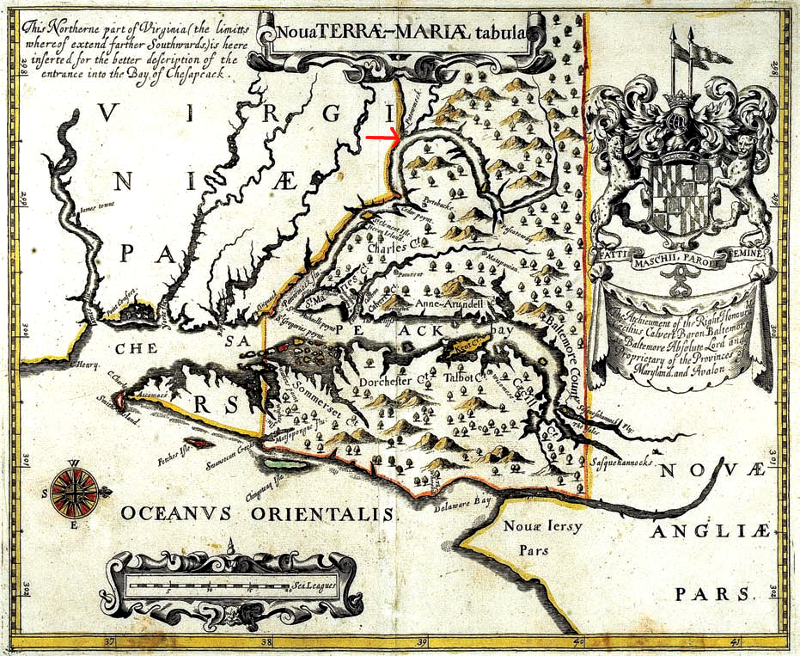
No one knows why the 1632 charter was so generous to Maryland, giving the entire Potomac River to Maryland instead of drawing the boundary in the middle of the river. The decision may have been intended to give Maryland officials an extra measure of control. George Calvert had visited Jamestown with his family in 1629, and the Virginia colonists had demonstrated their distrust of him both as a Catholic and a potential rival.
Another possibility is that no one in London cared much about the details of the boundaries, far across the Atlantic Ocean. In Lord Calvert's earliest maps of the colony, the location of the Potomac River was defined to Maryland's advantage. By defining Potomac Creek or Aquia Creek as the main stem of the river, the land to the north (starting at modern Stafford County) would be incorporated into Maryland.
It is hard to believe such efforts reflected ignorance of which stream was the main Potomac River. The first European known to have explored the area, John Smith, had clearly recognized in 1608 which channel was the main Potomac River and which creeks were the smaller tributaries.
the first map of Maryland placed the colony's southern boundary on the southern side of Aquia Creek in modern Stafford County
Source: Maryland State Archives, Nova Terrae-Mariae tabula (by Jerome Hawley and John Lewger, 1635)
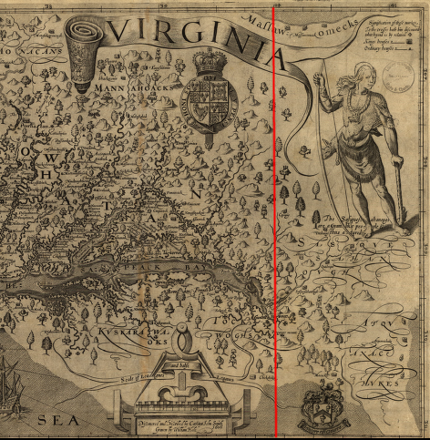
in 1721, John Senex duplicated Guillaume de L'Isle in using the Acconachena [Shenandoah] River as the Maryland-Virginia border
Source: Library of Congress, A Map of Louisiana and of the River Mississippi (by John Senex, 1721)
Complicating the status of the river, in 1688 James II modified the boundaries of the "Northern Neck" grant made originally by Charles II in 1649, and renewed as the Hopton grant in 1667. James II gave Lord Culpeper the entire Potomac River in 1688:4
All that entire tract, territory or parcel of land situate, lying and being in Virginia in America and bounded by and within the first heads or springs of the rivers of Tappanhannocke alias Rappahanocke and Quiriough alias Patawomacke Rivers, the courses of the said rivers, from their said first heads or springs, as they are commonly called and known by the inhabitants and descriptions of those parts, and the Bay of Chesapoyocke, together with the said rivers themselves and all the islands within the outermost banks thereof, and the soil of all and singular the premisses. (emphasis added)
In 1776, the first Constitution of Virginia acknowledged that the Maryland charter was valid, but avoided defining the limits of that state's claim to the Potomac River. The 1776 Virginia constitution did assert the right of Virginians to exercise free navigation on the Potomac and Pocomoke rivers, and to use the water and shoreline ("riparian rights"):5
The territories, contained within the Charters, erecting the Colonies of Maryland, Pennsylvania, North and South Carolina, are hereby ceded, released, and forever confirmed, to the people of these Colonies respectively, with all the rights of property, jurisdiction and government, and all other rights whatsoever, which might, at any time heretofore, have been claimed by Virginia, except the free navigation and use of the rivers Patomaque and Pokomoke, with the property of the Virginia shores and strands, bordering on either of the said rivers, and all improvements, which have been, or shall be made thereon.
Left unclear was determination of the location of the actual line on the south bank, the "further Bank of the said River" (in Latin, ad ulterioram predicti fluminis ripam).
Maryland manages oyster bars in the Potomac River, up to the boundary line with Virginia
Source: Maryland Department of Natural Resources, Maryland's Historic Oyster Bars
Virginians were not legalistic about defining the edge of the shoreline, or even respectful of Maryland's claim to the entire river. In Tidewater, the rise and fall of the tides can produce a wide, sandy beach/mudflat on the river's edge.
Above the high-water mark, defined by the edge of vegetation along the shoreline, the upland was clearly Virginia. Below the low-water mark (the normal edge of the water when the tide is out, "the point to which the water recedes at its lowest stage" according to Black's Law Dictionary), the river bottom was clearly Maryland. The shoreline itself could be interpreted as being in Virginia or in Maryland.6
A literal interpretation of the 1632 grant to Lord Baltimore might suggest the boundary was set at the high-water mark. Virginia landowners chose to interpret the right of "navigation and use" to include using the shoreline down to the low-water mark. Wharfs were built on the shore at plantations such as Stratford Hall, with no consideration of paying Maryland taxes for the shoreline real estate.
In 1688, Thomas, Lord Culpeper arranged to have King James II re-confirm the Northern Neck grant that Charles II had originally issued in 1649. By that time, Culpeper owned 5/6ths of what later became known as the Fairfax Grant. In his 1688 action, King James II used language that reversed ownership of the Potomac River by giving away (emphasis added):7
All that entire tract, territory, or parcel of land situate, lying, and being in Virginia in America, and bounded by and within the first heads or springs of the Rivers of Tappahannock als. Rappahannock and Quiriough als. Patowmack Rivers, the courses of said rivers from their said first heads or springs, as they are commonly called and known by the inhabitants and description of those parts and the Bay of Chesapeake, together with the said rivers themselves and all the islands within the outermost banks thereof...
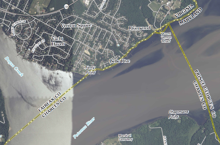
There was apparently no legalistic examination of language regarding the exact ownership of the shoreline in the 17th or 18th Century. George Washington operated a herring fishery in the Potomac River offshore from Mount Vernon. It provided a more reliable source of income than growing tobacco and wheat, but he never asked for permission or paid Maryland anything for catching "their" fish or using the land between the high-water and low-water marks.8
modern boundaries at the location of George Washington's fishery, near Ferry Point
Map Source: US Geological Survey (USGS), Mount Vernon 7.5 x 7.5 topographic map (2011)
Virginia's first constitution, adopted in 1776, sought to increase colonial unity by dropping Virginia's claims to lands within the chartered boundaries of Maryland. The Virginia constitution used language that did not clarify if the state still claimed ownership of the shoreline of the Potomac River down to the low-water mark:9
The territories, contained within the Charters, erecting the Colonies of Maryland, Pennsylvania, North and South Carolina, are hereby ceded, released, and forever confirmed, to the people of these Colonies respectively, with all the rights of property, jurisdiction and government, and all other rights whatsoever, which might, at any time heretofore, have been claimed by Virginia, except the free navigation and use of the rivers Patomaque and Pokomoke, with the property of the Virginia shores and strands, bordering on either of the said rivers, and all improvements, which have been, or shall be made thereon.
After the American Revolution, the new United States was only a loose confederation, governed by a weak national Congress. Maryland had refused to ratify the Articles of Confederation until 1781, maneuvering Virginia and other states into ceding their western lands claims (beyond the Ohio River) to the new national government first. Maryland could have asserted its right as an independent state and its claim to the Potomac River, and tried to tax commercial traffic going to Virginia ports such as Alexandria.
However, it was not clear how Maryland could enforce any claim based on the now-rejected authority of English kings. Virginia still remained the largest, most-populated state in the new nation, and the "United States in Congress Assembled" under the Articles of Confederation might not support ancient land grant claims by Maryland against Virginia.
In 1785, there was no judicial referee to resolve interstate conflicts. The idea of a Supreme Court, operating as an independent third branch of government, would not be established until the Constitution was ratified in 1788 and the court asserted its independence over the next 20 years. It was unclear how a weak national Congress could force Virginia to comply with Maryland's interpretation of its 1632 charter.
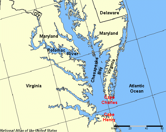
Besides, Virginia had real leverage to convince Maryland to resolve conflicting claims to use of the Potomac River: Virginia owned the mouth of the Chesapeake Bay. Virginia was an independent state that could tax all Maryland ships coming from the Atlantic Ocean into the Chesapeake Bay, before they sailed north to "Maryland's" Potomac River.
The tradeoffs to reach agreement were based on the shape of the bay as well as the colonial boundaries. While Maryland might own the Potomac River, Virginia controlled the entrance to the Chesapeake Bay. Under the Articles of Confederation, Virginia could impose a high tax on all vessels sailing between Cape Charles and Cape Henry on the way to the Potomac River.
All of Maryland's significant ports were on the bay and the rivers draining into the bay, such as Annapolis and Baltimore. There were no good harbors on Maryland's Atlantic coastline. As a result of natural and political geography, nearly all commercial traffic going to (or from) Maryland could be forced to pay an import or export fee on their cargoes passing through Virginia's portion of the Chesapeake Bay.
Bottom line: each state could wreak economic havoc on the other.
Virginia owns both Cape Charles and Cape Henry, so it controls the mouth of the Chesapeake Bay
Source: National Atlas
The solution was to negotiate, in order to encourage rather than block each state's commerce and economic development. Maryland supported chartering the Potowmack Company in 1784, which would benefit both states, and agreed to send delegates in 1785 to a meeting regarding commercial use of the river.
Each state appointed commissioners to negotiate a compact. The commissioners met initially in Alexandria, then moved to Mount Vernon. In part because George Washington hosted the discussions (even though the Virginia General Assembly had not designated him as a commissioner), the negotiators crafted the Compact of 1785 and the General Assemblies of both states ratified the deal.
Maryland and Virginia agreed in the Compact of 1785 that neither state could interfere with the other's trade or fishing on the Potomac River. Virginia and Maryland also agreed to allow each other free access on the Chesapeake Bay. The first provision in the Compact of 1785 stated:10
The commonwealth of Virginia disclaims all right to impose any toll; duty or charge, prohibition or restraint, on any vessel whatever sailing through the capes of Chesapeake bay to the state of Maryland, or from the said state through the said capes outward bound; and agrees that the waters of Chesapeake bay, and the river Pocomoke, within the limits of Virginia, be for ever considered as a common highway, free for the use and navigation of any vessel belonging to the said state of Maryland, or any of its citizens, or carrying on commerce to or from the said state, or with any of its citizens, and that any such vessel, inward or outward bound, may freely enter any of the rivers within the commonwealth of Virginia as a harbour, or for safety against an enemy, without the payment of port duties, or any other charge; and also that the beforementioned parts of Chesapeake and Pocomoke river be free for the navigation of vessels from one port of the state of Maryland to another.
Through that statement, Virginia traded away its theoretical ability to impose tolls on Maryland vessels entering the Chesapeake Bay between Cape Charles and Cape Henry, near Norfolk. In exchange, Virginia was guaranteed free access to the Potomac River.
The challenges in resolving the Virginia/Maryland issues through bi-state negotiations revealed clearly that the new national government was not capable of dealing with multi-state concerns. To comply with the Articles of Confederation, Virginia and Maryland were supposed to get approval by a majority of the Congress, where other states could be competitive rather than cooperative and potentially block commercial development in the Chesapeake Bay region:11
The commissioners called for another meeting among all the states to address larger interstate commerce issues. This led to the Annapolis Convention, which begat the Constitutional Convention in Philadelphia in 1787, which begat the Constitution and the current political structure for the United States of America. The Virginia/Maryland border dispute triggered the conflict resolution process that led to the Commerce Clause authorizing the new Federal Government to "regulate commerce with foreign nations, and among the several states, and with the Indian tribes."
To get a sense of the challenge under the Articles of Confederation to resolve the interstate conflict over the rights to the Potomac River, look at today's debates over the relative authority of individual states in the European Union. In 1785 it was not clear that the 13 new states would remain under one federal government, just as the future of the European Union is unclear today. The development of the Constitution was not pre-ordained, and the leaders of the newly-independent states had no crystal ball showing that a new Constitution would change the authorities of the individual states.
Like the Articles of Confederation, the new Constitution required that interstate compacts had to be approved by the national Congress. No two states would be allowed to cut side deals without concurrence by all the other states. However, the Compact of 1785 was "grandfathered in" because it preceded adoption of the national Constitution. In 1958, another compact between Maryland-Virginia to resolve boundary issues was ratified by the US Congress.
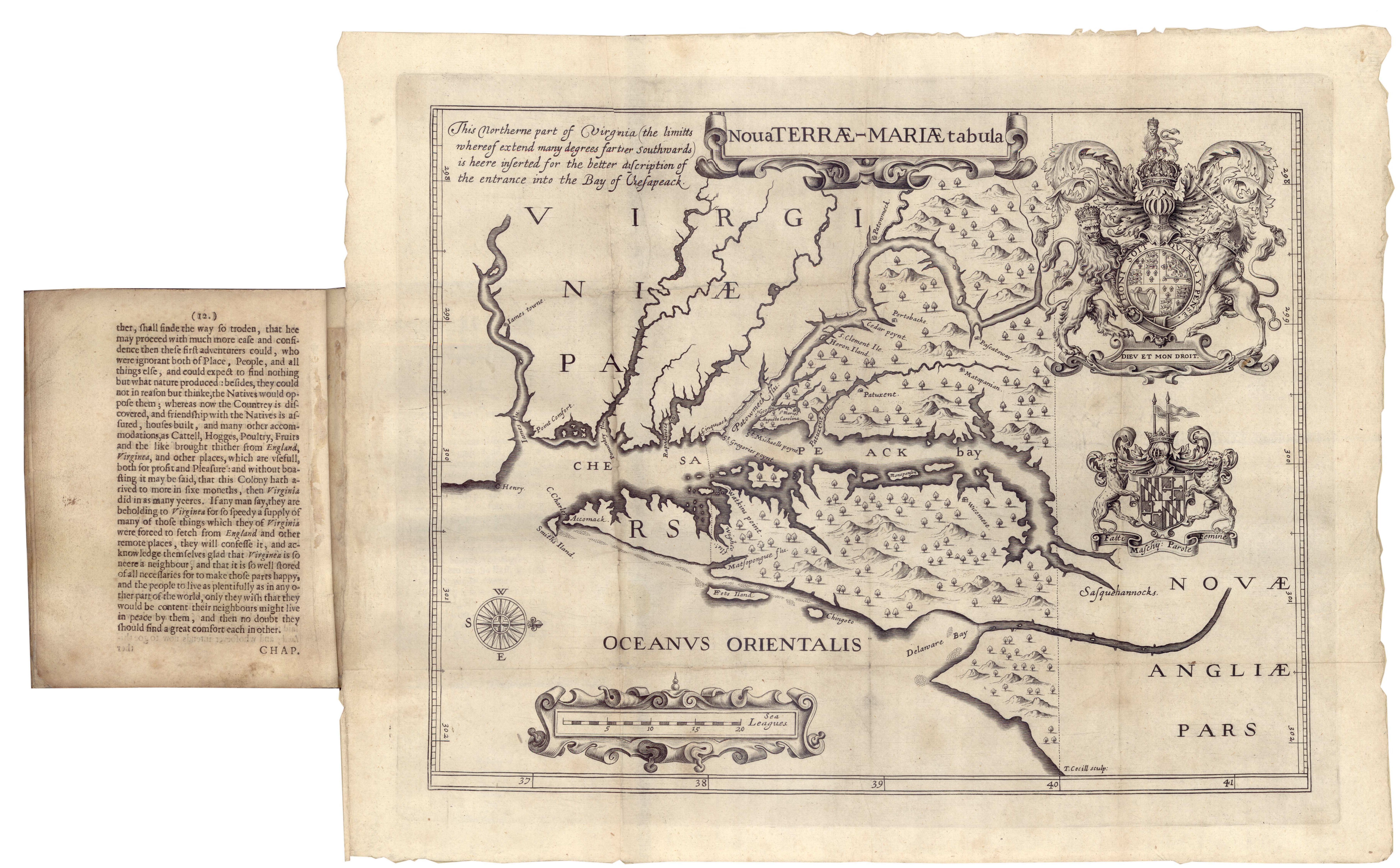
The Compact of 1785 resolved the dispute over navigation and taxation. It also made clear that Smith's Point was the mouth of the Potomac River and the starting point for the line across the Chesapeake Bay. Maryland made no effort to extend its claim south to the location of Cinquack, as marked on John Smith's map.12
However, the Compact of 1785 did not fix the location of the boundary line along the Potomac River, or clarify if the high-water mark or the low-water mark should be used. Ultimately, a lawsuit in the District of Columbia led to a US Supreme Court decision that determined ownership of the shoreline, and surveys that marked a fixed boundary on the southern bank of the Potomac River. The Potomac River became the first clear inter-colonial boundary in 1632, and the river as a natural feature has remained as the interstate boundary. In the lower 48 states, all but Montana, Wyoming, Utah and Colorado use rivers to define a portion of their state boundaries.13
In 1829, a canal was opened to connect the northern tip of the Chesapeake Bay to the Delaware Bay. The Chesapeake and Delaware Canal bypassed the passage of Baltimore-bound shipping through Virginia, via the natural opening at Cape Charles/Cape Henry, and now carries 40% of all the shipping to the port of Baltimore.14
Had the Chesapeake and Delaware Canal been built before the Compact of 1785, ships would have been able to sail between Baltimore and the Atlantic Ocean without having to use the mouth of the Chesapeake Bay and sail through Virginia waters. Without the leverage of control over traffic in the lower Chesapeake Bay, Virginia would have been in a weaker position to bargain with Maryland. Virginia's rights to use the Potomac River, including extension of wharves from the shoreline, may have evolved differently.
the Chesapeake and Delaware Canal allows ships to take a shortcut from the Chesapeake Bay to the Delaware Bay, bypassing Virginia completely
Source: ESRI, ArcGIS online
Determining exactly where to draw the boundary line was a political, surveying, and legal decision. Rather than ask the Supreme Court to make a decision, Virginia and Maryland agreed to a commission of arbitrators. Their final decision is known by the name of two of the three commissioners, Jeremiah S. Black of Pennsylvania and Charles J. Jenkins of Georgia. The third commissioner, James B. Beck of Kentucky, did not agree with the boundary decision for the Eastern Shore section.
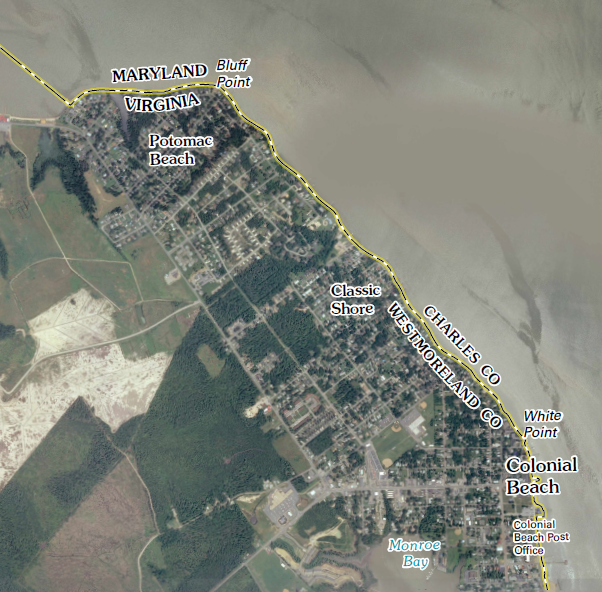
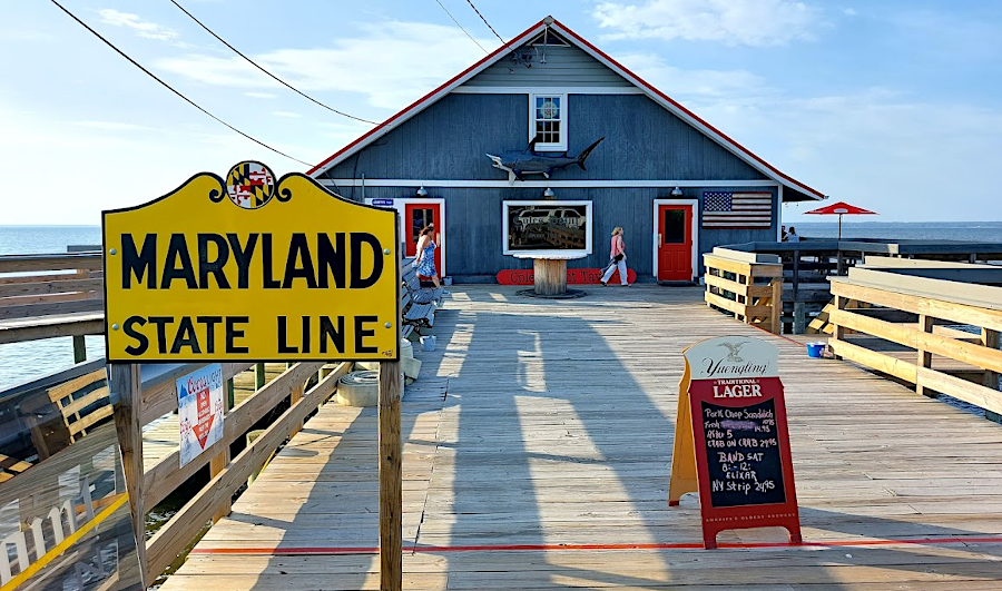
Colonial Beach is part of Westmoreland County, Virginia... but the Potomac River just offshore is located in Charles County, Maryland
Map Source: US Geological Survey (USGS), Colonial Beach North 7.5 x 7.5 topographic map (2011)
In the Black-Jenkins arbitration decision of 1877, Maryland's boundary was determined to be the low-water mark on the southern shore of the Potomac River. Maryland's 1632 charter had granted it ownership of the Potomac River shoreline up to the high-water mark, unto the further Bank of the said River.
The arbitration decision modified the Virginia-Maryland boundary along the Potomac River, as defined by a literal interpretation of the language in the charter given by Charles I to the Calverts. The size of Virginia expanded slightly.
Maryland lost the land between the high-water mark and the low-water mark because of "prescriptive use" of that riparian area by Virginians since the Compact of 1785. Since Maryland had not objected effectively to Virginians using the shoreline between the high-water and the low-water mark, the arbitrators decided that the line of traditional use should be adopted as the boundary. In the 1910 decision in Maryland v. West Virginia, the US Supreme Court ruled that the boundary between Maryland and West Virginia was also the low-water mark.
The adjudicators affirmed that islands within the Potomac River were owned by Maryland. Virginia gained no right to sell submerged lands underneath the Potomac River in the Black-Jenkins arbitration decision. As noted in a later US Supreme Court decision:15
The record discloses no evidence that at any time any substantial claim was ever made by Lord Fairfax, heir at law of Lord Culpeper, or by his grantees, to property rights in the Potomac River or in the soil thereunder, nor does it appear that Virginia ever exercised the power to grant ownership in the islands or soil under the river to private persons. Her claim seems to have been that of political jurisdiction.
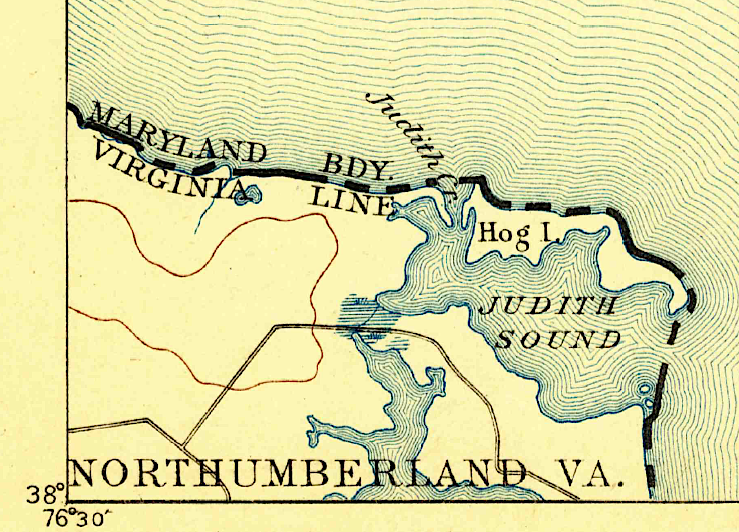
There was a dispute regarding Hog Island near the Coan River, with debate regarding whether it was "in" or "on" the Potomac River. The final decision gave the island and associated oyster beds to Virginia, in order to avoid having the boundary curve in and out of every little indentation on the shoreline. The island has since washed away.
The General Assemblies of Virginia and Maryland approved the 1877 decision by the arbitrators. The US Congess confirmed it in 1879. By that Congressional action, it also confirmed the Conmpact of 1785 which had been negotiated before the US Constitution was created.
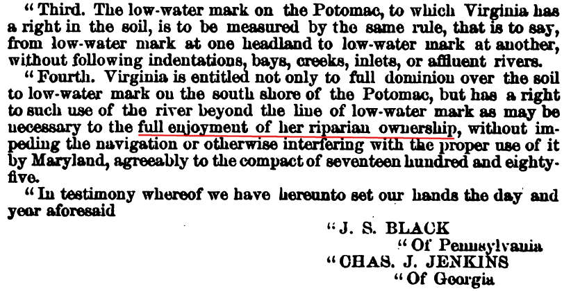
To minimize confusion about the location of the low-water mark, the line downstream of Washington DC was defined as a fixed boundary to be define by a survey. The arbitration decision in 1877, as confirmed in 1879, even authorized Virginians to build improvements on the riparian area, such as wharves extending out from the shoreline, so long as they did not block navigation:16
Third. The low-water mark on the Potomac, to which Virginia has a right in the soil, is to be measured by the same rule, that is to say, from low-water mark at one headland to low-water mark at another, without following indentations, bays, creeks, inlets, or affluent rivers.
Fourth. Virginia is entitled not only to full dominion over the soil to low-water mark on the south shore of the Potomac, but has a right to such use of the river beyond the line of low-water mark as may be necessary to the full enjoyment of her riparian ownership, without impeding the navigation or otherwise interfering with the proper use of it by Maryland, agreeably to the compact of seventeen hundred and eighty-five.
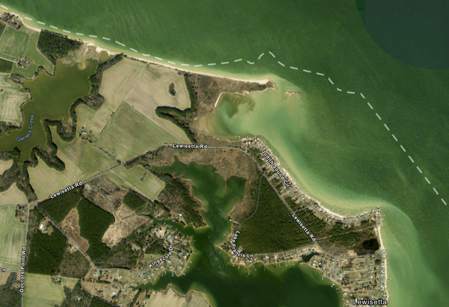
In 1889, the two states disputed the boundary near what is now Lewisetta in Northumberland County. Henry Whiting in the United States Coast and Geodetic Survey interpreted the Black-Jenkins arbitration decision and the states accepted his opinion.
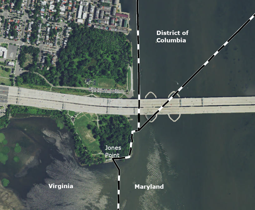
The arbitrators in 1877 had called for the low-water line to be converted into a fixed surveyed line on the tidal portion of the Potomac River, from Jones Point downstream to Smith Point. A fixed boundary would eliminate the need for interpreting the Black-Jenkins arbitration decision.
In 1927 Maryland and Virginia tasked their state geologists to define a fixed boundary. Edward B. Mathews from Maryland and Wilbur A. Nelson from Virginia identified specific headlands on the southern bank that jutted out into the river, with embayments between them. Establishing a straight line between headlands as the state boundary would eliminate the need to interpret how the location of the riverbank changed by the natural processes of accretion and reliction (erosion), thus changing the location of the state boundaries. Maryland benefitted by avoiding legal disputes, while granting Virginia control over waters within embayments between headlands.
The Mathews-Nelson survey defined a boundary based primarily upon straight lines:17
from low-water mark at one headland to low-water mark at another, without following indentations, bays, creeks, inlets, or affluent rivers.
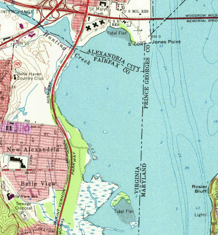
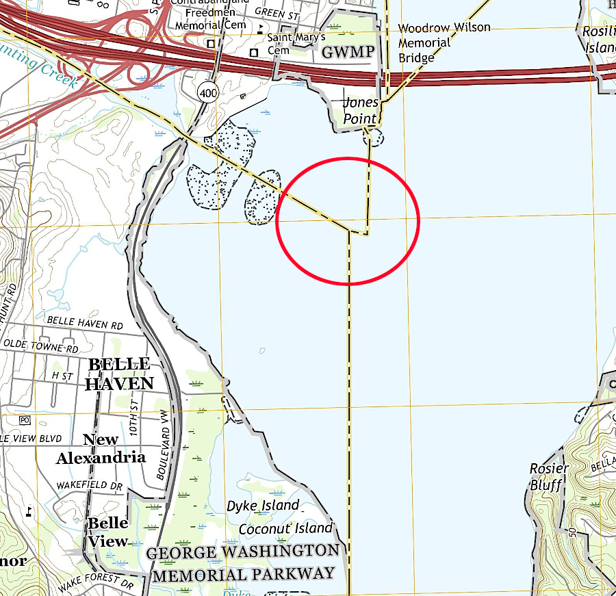
Shallow-water embayments were granted to Virginia, and the Maryland-Virginia state line crossed between points of land (headlands) jutting into the Potomac River. As a result, the state boundaries downstream from Jones Point do not follow the shoreline exactly, and the boundaries do not change when land is eroded away from the shoreline or accreted to it.
the straight Mathews-Nelson line defines the Virginia-Maryland boundary south of Jones Point and the Woodrow Wilson Bridge
Source: US Geological Survey (USGS), Alexandria VA 1:24,000 topographic quadrangle (2019)
The Mathews-Nelson line simplified the challenge of determining jurisdiction in coves along the Virginia shoreline, replacing the low-water mark as the boundary between those headlands where straight lines were marked by 58 concrete monuments.
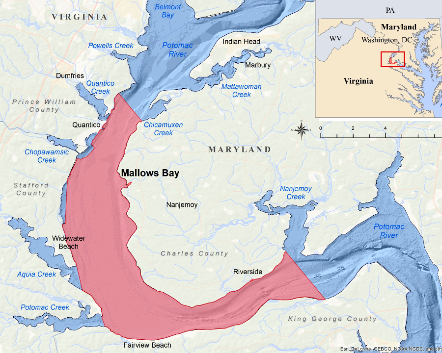
when the National Oceanic and Atmospheric Administration (NOAA) proposed a new marine sanctuary on the Potomac River in 2017, the Federal agency proposed boundaries based on the Mathews-Nelson line
Source: National Oceanic and Atmospheric Administration (NOAA), Mallows Bay - Potomac River
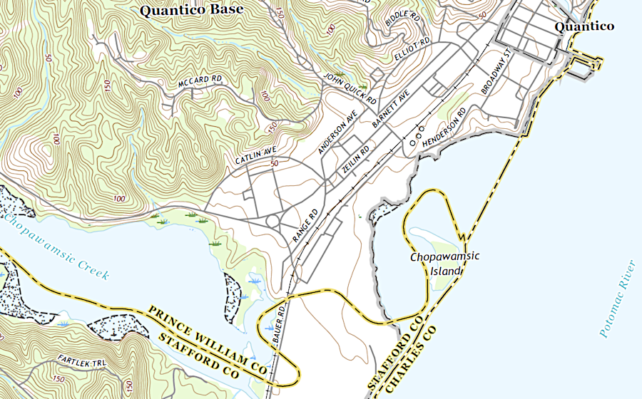
When Mathews and Nelson surveyed the boundary near Quantico, they chose a line between headlands that left Chopawamsic Island within Virginia. The first owner supposedly was Giles Brent, with a 1649 patent. It was known later as Scott's Island, perhaps because Reverend Alexander Scott, the rector of Aquia Church, acquired it when he established Dipple Plantation on the mainland. Marines now refer to Chopawamsic Island 300 yards offshore from their base as "Chop Island" or, because of its shape, "Pork Chop Island."
The island was used as a hunting retreat until the 1930's; President Theodore Roosevelt hunted waterfowl there. When the Federal government purchased land in 1917 to create Marine Corps Base Quantico, it left the island in private ownership. The island is off-limits to Marines at the base, and access to the water on the western side of the island (closest to the base) is limited. However, a real estate agent once noted that the private owners had a front-row seat to seeing the president's helicopter take off and land, on its way from the HMX-1 hangar at Quantico to the White House.
after the Mathews-Nelson line was surveyed and adopted, Chopawamsic Island offshore from Marine Corps Base Quantico ended up in Stafford County, Virginia
Source: US Geological Survey (USGS), Quantico, VA 1:24,000 topographic quadrangle (2019)
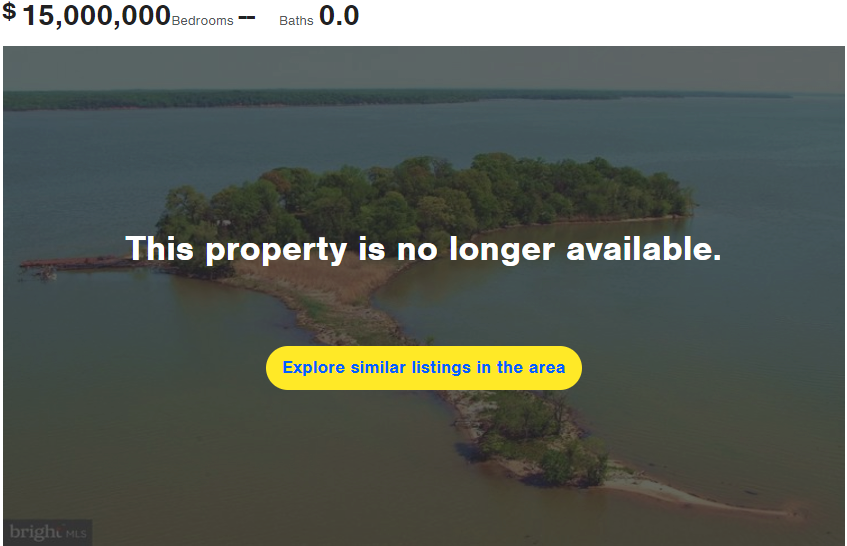
A doctor at the Marine Corps Base Quantico hospital purchased Chopawamsic Island in 1958. He restored the three houses that had not been occupied since the Great Depression, and even built a swimming pool. Electricity came via an underwater cable from the base; water came from a well. The highest point on the island was 13' above sea level, protected from river floods.
The doctor's family sold the 13-acre island for $500,000 in 1979. The buyers tried to resell it in 1989 for $1.1 million, but in 1991 accepted an offer for $375,000. In 2018, Chopawamsic Island was listed for sale with a $15 million price tag, but then took it off the market.18
the attempt to sell Chopawamsic Island for $15 million in 2018 was unsuccessful
Source: Weichert Realty, Chopawamsic Island
The low-water mark boundary was not altered upstream of Jones Point by the Mathews-Nelson survey. In 2014, a court determined that the normal alteration of that shoreline would shift the boundary as well, ensuring that all the land above the low-water mark on the Virginia side would stay in Virginia.
Where the low-water mark still defines the boundary, property owners on the Virginia side of the river can gain acreage through accretion when natural sediment deposition expands the size of a parcel. Similarly, parcels shrink through reliction, when erosion reduces the amount of land on one part of a shoreline as the channel shifts slowly.19
downstream of Jones Point, the Maryland-Virginia border is defined between key headland points by the straight lines of the Mathews-Nelson survey
Map Source: US Geological Survey (USGS), Colonial Beach South 7.5 x 7.5 topographic map (2011)
In 1940, Congress gave its consent to a new interstate compact for managing the Potomac River. Maryland, West Virginia, Pennsylvania, Virginia, and the District of Columbia entered into a Congressionally-approved compact that created the Interstate Commission on the Potomac River Basin (ICPRB) and the Potomac Valley Conservancy District, to address water quality and related land resources issues in the Potomac River watershed.
In the 1950's, the dispute between Maryland and Virginia over rights to oysters and other resources in the Chesapeake Bay/Potomac River turned violent again. Both states armed patrol vessels and renewed "Oyster Wars" led to a effort to abrogate the Compact of 1785. Virginia started a lawsuit at the Supreme Court, but state officials were able to negotiate their differences and replaced the Compact of 1785 with the Compact of 1958.
The 1958 agreement established the Potomac River Fisheries Commission. It defined the jurisdictional boundaries for that commission's powers in great detail for the Maryland side of the Potomac River, but simply referencing the mean low-water mark of the Potomac River on the Virginia side (as marked by the Matthews-Nelson Survey of 1927). After both the Virginia and Maryland legislatures and the Maryland voters approved the 1958 agreement, Congress affirmed it in 1962.
Based on court decisions, the Maryland-Virginia border upstream of the District of Columbia was defined as the low-water mark on the Virginia shoreline. As the shoreline changes gradually by accretion and erosion, the boundary shifts.
Within the Disatrict of Columbia, the boundary is the high-water mark from Little Falls downstream to the city of Alexandria. Within the city, the boundary is the pierhead line surveyed by the US Army Corps of Engineers.
Downstream of Jones Point, the boundary is a fixed survey line. It follows the shoreline in places, but cuts in a straight line between different headlands.
modern boundaries of Maryland
Source: Ray Sterner, Color Landform Atlas of the United States, modern boundaries of Maryland
In 2003, another US Supreme Court decision reaffirmed that the 1877 Black-Jenkins arbitration decision gave Virginians the right to use the riparian area beyond the low-water mark. Structures could extend from the Virginia shoreline, intruding into Maryland, without having to get permission from that state.
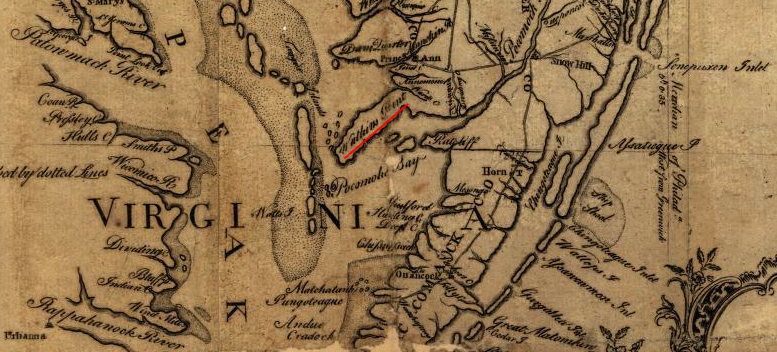
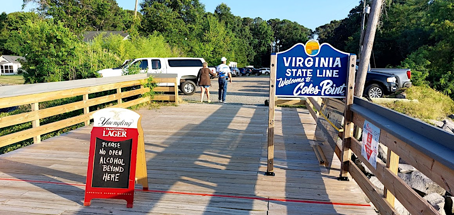
Coles Point Tavern on the Potomac River is in St. Mary's County (Maryland), and a red line marks the boundary with Westmoreland County (Virginia)
Fairfax County had installed a water pipe in the bed of the Potomac River, beyond the low-water mark, and pumped clean water from near the middle of the river to the Corbalis Water Treatment Plant. Maryland objected, but the US Supreme Court ruled that Fairfax County was authorized to "the full enjoyment of her riparian ownership, without impeding the navigation or otherwise interfering with the proper use of it by Maryland."20
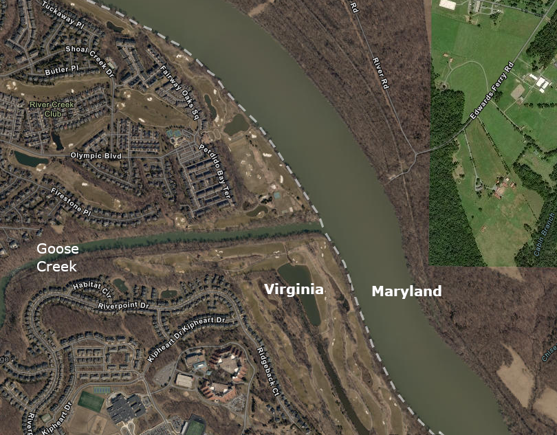
Questions regarding the Maryland-Virginia boundary delayed response by emergency personnel to a drowning in June 2020, at the mouth of Goose Creek. A 16-year old boy attempted to swim across the confluence of Goose Creek and the Potomac River, and when he disappeared his companions called 911. Dispatchers send personnel first from Montgomery County, Maryland; Montgomery County had easy access to get boats on the Potomac River at Edwards Ferry. Loudoun County responders did not arrive for 30 minutes. After the death, Loudoun County changed policy and decided to send emergency personnel immediately to incidents in the Potomac River, even if it turns out later that Maryland officials will have jurisdiction.
That same month, the District of Columbia rescued 12 people trapped on rocks one day near Chain Bridge, in the Potomac River. Rising waters after a rainstorm stranded them on three different groups of rocks, after the people had walked from the Virginia shoreline across the state line. The D.C. Fire and EMS personnel and the D.C. Police Harbor Patrol managed the rescue without needing assistance from Arlington County.21
after a drowning in 2020 at the mouth of Goose Creek, Loudoun County decided to respond to Potomac River incidents first and resolve jurisdictional authority later
Source: ESRI, ArcGIS Online
Maintaining ownership of the Potomac River was the only boundary fight in which Maryland managed to maintain most of its original claims. It lost battles with Pennsylvania to define the eastern and northern sides of the colony.
The 1632 charter for Maryland defined its boundary "unto that Part of the Bay of Delaware on the North, which lieth under the Fortieth Degree of North Latitude."
The 1681 charter for Pennsylvania also used the 40th parallel, setting Pennsylvania's southern boundary "on the South by a Circle drawne at twelve miles distance from New Castle Northward and Westward unto the beginning of the fortieth degree of Northern Latitude, and then by a streight Line Westward."22
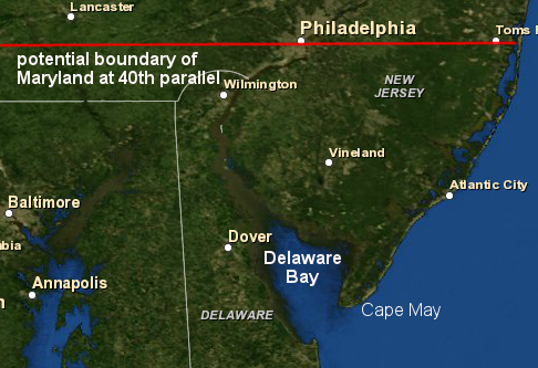
The geography surprise was that the 40th parallel of latitude was further north than expected. It ran through what became Philadelphia, not through the northern tip of the Chesapeake Bay. A circle with a twelve miles radius centered on New Castle did not intersect the 40th parallel, so a key spot used to define the Maryland-Pennsylvania boundary did not exist.
Delaware Bay and the southern 1/3 of New Jersey could have been part of Maryland
Map Source: US Fish and Wildlife Service, Wetlands Mapper
If the Calverts had succeeded in getting the 40th parallel defined as the boundary, then Maryland would have controlled the mouth of the Delaware River.
Maryland's control of the Delaware Bay entrance would have been comparable to Virginia's control of Cape Charles/Cape Henry at the mouth of the Chesapeake Bay. All ships sailed to Philadelphia through the Delaware Bay. Under the Articles of Confederation, Maryland might have taxed all ships going to and from the Delaware River to the Atlantic Ocean, constraining Pennsylvania's commercial development.
The Calverts lost their fight with the Penns and were to accept a boundary line south of Philadelphia, 15 miles below the 40th parallel. Charles Mason and Jeremiah Dixon surveyed the northern border of Maryland in 1763-1767.
Pennsylvania also blocked Maryland from acquiring control of three counties along the western shore of Delaware Bay, territory that had been settled earlier by Swedes and Dutch. The three counties ended up becoming the separate colony of Delaware, while the eastern shore of Delaware Bay - including Cape May - ended up as part of New Jersey.
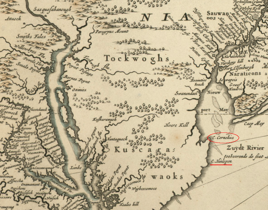
The Penns and Calverts agreed that the southern border of the Lower Counties would be defined by a line starting at Cape Henlopen. The map used to identify the site of Cape Henlopen mistakenly showed it to be further south, at what today is known as Fenwick Island. When the Calverts discovered the error, they sought to modify the deal and have the boundary drawn further north, which would have increased the acreage within Maryland. Officials in London rejected the efforts to incorporate in Maryland what today is the southern third of Delaware.23
the Calverts and Penns used an incorrect map that labeled Fenwick Island as Cape Henlopen, but the Calverts later failed in their efforts to get the correct location - marked on the map as Cape Cornelius - used to define the southern border of the Lower Counties (Delaware)
Source: New York Public Library, Novi Belgii Novaeque Angliae nec non partis Virginiae tabula (by Nicolaes Visscher, 1690)
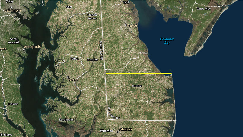
territory south of the yellow line ended up in Delaware instead of Maryland, due to mis-location of Cape Henlopen on map
Source: ESRI, ArcGIS Online
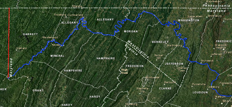
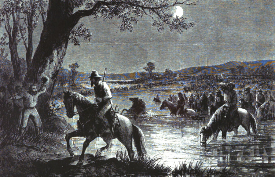
when the Army of Northern Virginia invaded Maryland in August, 1862, it crossed the border when soldiers and horses first got their feet wet in the Potomac River
Source: Harper's Pictorial History of the Civil War, Pope's Campaign in Virginia (p.392)
![the French in 1718 defined the Acconachena [Shenandoah] River as the Maryland-Virginia border](graphics/french1718mdvaborder.png)
![in 1721, John Senex duplicated Guillaume de L'Isle in using the Acconachena [Shenandoah] River as the Maryland-Virginia border](graphics/senex1719.png)


