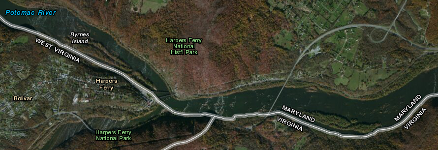
the confluence of the Shenandoah and Potomac rivers is now close to the boundary between three states
Source: US Fish and Wildlife Service, Wetlands Mapper
the confluence of the Shenandoah and Potomac rivers is now close to the boundary between three states
Source: US Fish and Wildlife Service, Wetlands Mapper
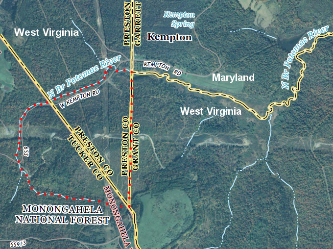
The 1632 land grant to the Calverts established that the Potomac River would be the boundary between Virginia and Maryland, and that Maryland would "own" the entire river. Several key disputes regarding which stream was the Potomac River and where was its beginning ("headspring") were resolved before the Civil War, during the time when Virginia and Maryland bordered each other all the way to Maryland's western boundary.
A US Supreme Court decision in 1866 affirmed that Jefferson County was part of West Virginia. Since then, the edge of the Potomac River - from the Loudoun Heights at Harpers Ferry to the headspring - has separated West Virginia and Maryland upstream.
In 1736 the surveyors of the Fairfax Grant started at the confluence of the Shenandoah and Potomac rivers, where Harpers Ferry would develop later. The Shenandoah was just another tributary flowing through Virginia, and did not define a state boundary at the time. Today, the river approximates the border between Virginia-West Virginia at Harpers Ferry.
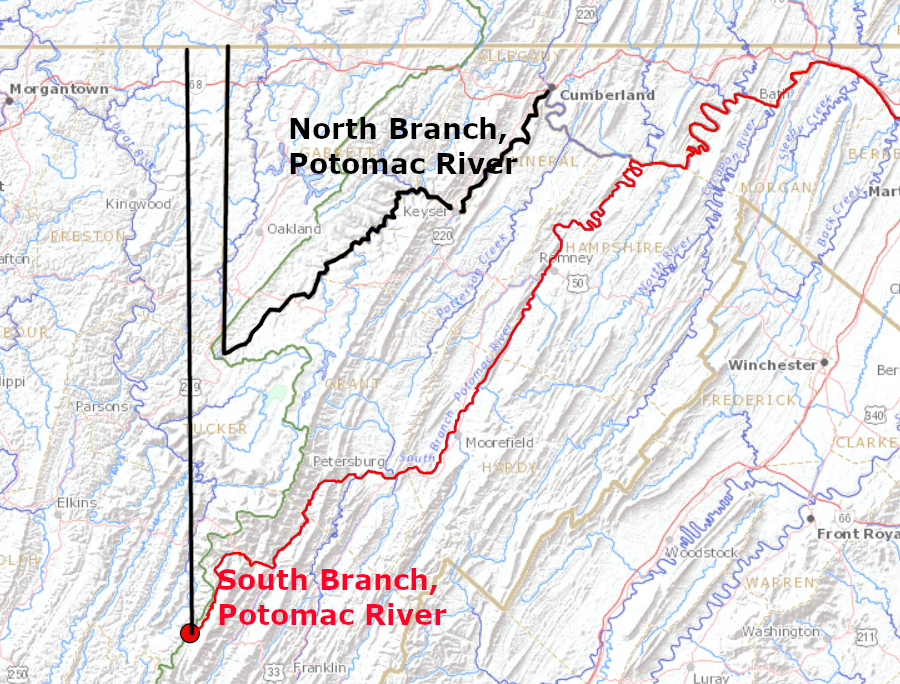
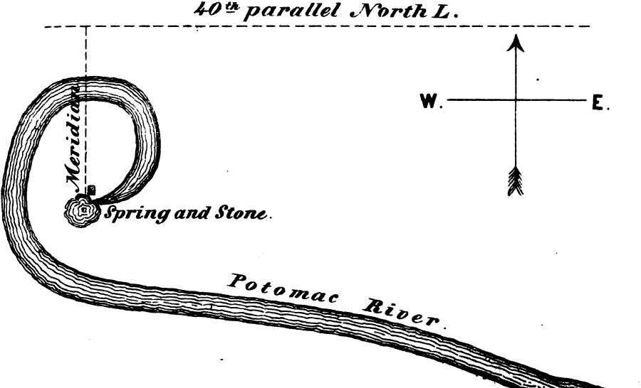
The surveyors chose the headspring of the North Branch (with its wider valley) as the source of the Potomac River, rejecting the option of the South Branch of the Potomac River. The water flow of the two is about equal, but a traveler going upriver would continue straight to follow the North Branch. A traveler would have to make a 90-degree left turn to follow the South Branch. The surveyors marked blazes on trees and scratched "Fx" into a stone placed at the head of the North Branch of the Potomac River in 1736.
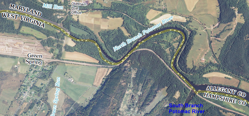
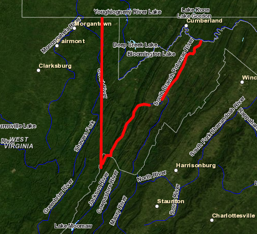
the confluence of the South Branch with the North Branch of the Potomac River is just downstream of Oldtown, Maryland
Source: US Geological Survey (USGS), Oldtown 7.5x7.5 topographic map (2011)
Lord Fairfax and the colony of Virginia had separate teams of commissioners and their hired surveyors when marking the boundaries of the Fairfax Grant. The colony of Maryland had no participants in the 1736 survey that determined the headspring of the Potomac River and thus Maryland's western edge.
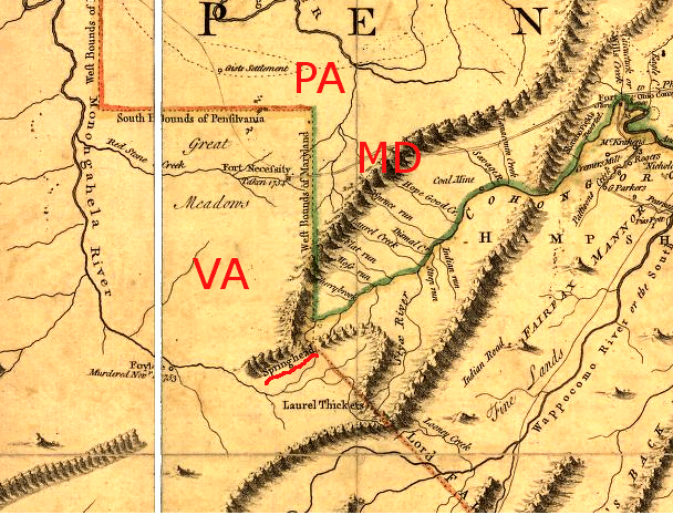
location of Fairfax Stone at "springhead," as depicted on Fry-Jefferson Map of 1755
Source: Library of Congress, Fry-Jefferson Map
In 1753, Maryland sought to have the South Branch used as the border. Designating the South Branch as the main stem would have enlarged Maryland's territory on its western and southwestern borders. The French and Indian War intervened, followed by the American Revolution, and Virginia did not react to that proposal.1
Maryland would have been enlarged if the South Branch of the Potomac River was designated as the main stem and became the state boundary
Source: US Geological Survey (USGS), Streamer
The Potomac River was an obvious natural feature defining the southern edge of the state, but the northern edge was unclear as the Calverts and Penns disputed the appropriate way to define the 40th degree of latitude. In the 1760's, Maryland finally resolved its disputed northern boundary with Pennsylvania with the survey of the Mason-Dixon line. Because both branches of the Potomac River originated at a southern point and flowed north, Maryland had a wedge of land on its western tip - but ended up being only two miles wide at Hancock, and five miles wide at Cumberland.
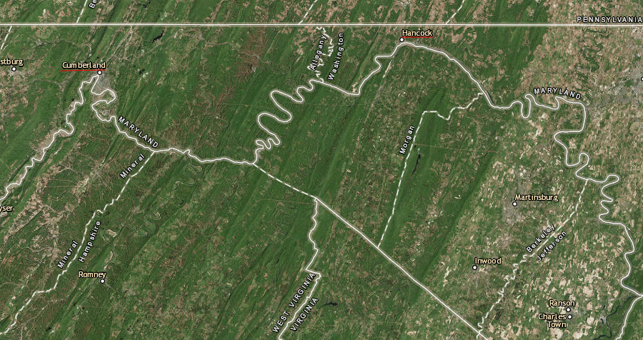
resolution of the Pennsylvania-Maryland boundary left Maryland only two miles wide at Hancock, and only five miles wide at Cumberland
Source: ESRI, ArcGIS Online
In 1788, Maryland hired Francis Deakins to survey a line due north of the Fairfax Stone. The Maryland General Assembly planned to authorize 50-acre parcels for soldiers who had fought in the Revolutionary War. A western boundary separating Maryland-Virginia was required, in order to identify where Maryland had authority to issue grants to its veterans.
The Deakins Line ran north from the Fairfax Stone to the Pennsylvania border. It became the traditional boundary that everyone used to define the western edge of Maryland, where a narrow stretch next to Virginia was not defined by the Potomac River.
The 1788 Maryland General Assembly noted that it considered the correct boundary to be further west of the Deakins Line. Maryland tried to get Virginia to appoint commissioners to adjust the line in 1795, 1801, and 1810. After another effort by Maryland in 1818, Virginia did appoint commissioners, but no action followed their initial meeting in 1822.
In 1834, Maryland finally sued Virginia. The suit claimed that the western edge of the colonial grant to Virginia was the South Branch of the Potomac River, not the North Branch. A suit between two states is a case of "original jurisdiction," so the suit went directly to the US Supreme Court - but the suit was dismissed. Then in 1854, Virginia appointed commissioners in response to another Maryland effort, and the commissioners jointly asked the Federal government to provide a topographical engineer to resurvey the boundary.
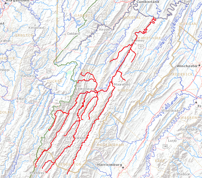
if the South Branch of the Potomac River had been chosen to define the "headspring," the southwestern border of Maryland would have been 50 miles further south and beyond the latitude of Harrisonburg
Source: US Geological Survey (USGS), Streamer
In 1859 Lieut. N. Michler surveyed another line straight north from the Fairfax Stone, using more-accurate equipment. The original stone was found by Lieutenant Michler, who reported:2
In comparison to the Deakins Line surveyed in 1788, the Michler Line veered to the west and reached the Pennsylvania boundary 3/4 of a mile further west. If Michler's survey was the correct boundary line, then a triangular slice of Maryland had been inappropriately governed by Virginia since the Deakins Line was completed.
Maryland quickly approved Michler's survey. In 1887 the new state of West Virginia (created in 1853) also approved a new boundary line based on Michler's survey, but West Virginia imposed conditions on its approval that Maryland ultimately rejected. That same year, Virginia and Maryland agreed to resolve their boundary disputes in arbitration, but that did not happen.
A decade later in 1897, Maryland asserted that the Fairfax Stone should have been placed on a different creek. The state placed a Potomac Stone where it claimed the "first fountain" flowed off Backbone Mountain.
how Maryland would have been enlarged and Virginia (mostly West Virginia now...) would have been reduced, if the headspring at the South Branch of Potomac River had been chosen in 1736
Source: ESRI, ArcGIS Online (with US EPA Hydrography layer)
In 1910, the US Supreme Court ruled that
1) the West Virginia-Maryland boundary would be based on the North Branch, and
2) the Maryland-West Virginia boundary would be the 1788 Deakins Line, beginning about one mile north of the Fairfax Stone where the Deakins line crossed the North Branch.
The court's rejection of the 1859 Michler Line was based on the philosophy of adverse possession. The court did not claim that the 1788 Deakins survey was as accurate as the 1859 Michler survey; instead, the court ruled that accuracy was not the issue.
If accurate tracing of the line north from the Fairfax Stone to the Pennsylvania border was the basis for the Maryland-West Virginia boundary in 1910, then the Supreme Court could have moved the disputed triangle between the Deakins Line and the Michler Line from West Virginia to Maryland. Instead, the court confirmed long-utilized boundaries based on the surveys in 1736 and 1788 in order to minimize disruption of traditional land boundaries and property ownership claims, and determined that it was irrelevant if Michler's 1859 survey was more accurate than Deakins's 1788 survey.
There were other boundary complications other than the contested triangle defined by the Michler/Deakins surveys. Because the Potomac River flowed west from the Fairfax Stone before curling around back to the east, there was confusion regarding whether Maryland included a horseshoe of land between the "head" and where the Deakins line crossed the Potomac River.
the curl of the Potomac River and the Supreme Court's 1910 decision to use the Deakins Line as the state boundary resulted in the site of the original Fairfax Stone being located completely in West Virginia
Source: Commission on Boundary Lines, Report and Accompanying Documents of the Virginia Commissioners Appointed to Ascertain the Boundary Line Between Maryland and Virginia (p.89)
Based on the 1910 court decision, the segment of land created by curl of the Potomac River to the west ended up completely within West Virginia. As a result, the site of the Fairfax Stone itself is not on the border with Maryland. The stone itself has long disappeared, and the original site is within a West Virginia state park.
the Potomac River curls west and north of the Fairfax Stone, and the Supreme Court determined in 1910 that Maryland's border started north of the Fairfax Stone (leaving land within red dotted line in West Virginia)
Source: US Geological Survey (USGS), Davis 7.5 x 7.5 topographic map (2014)
The Supreme Court also determined in 1910 that the low-water mark of the south bank of the Potomac River was the Maryland-West Virginia boundary.
The original 1632 Maryland charter extended the colony's ownership to the high-water mark on the southern side of the Potomac River. However, the court ruled that years of prescriptive use should be applied and West Virginia landowners should control property to the low-water mark.
That same reasoning had been used in the 1877 Black-Jenkins arbitration decision between Virginia and Maryland. That decision gave Virginia control over the southern bank of the Potomac River down to the low-water mark. West Virginia was a separate state in 1877, so the arbitration decision was limited to Virginia's portion of the Potomac River. It took another three decades before the 1910 decision by the Supreme Court established the same boundary at Harper's Ferry and upstream.
A 2014 decision by the Court of Special Appeals of Maryland determined that the low-water boundary between Maryland and West Virginia would shift, as the river channel eroded or deposited sediments. A Maryland rafting company had claimed it owned land on the south bank at the Potomac Wayside, where people crossed from the upland owned by Virginia to launch their own boats. The company wanted to charge people for using the land, which it claimed under a Maryland deed.
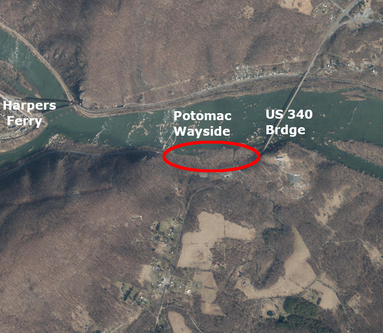
the Court of Special Appeals of Maryland ruled in 2014 that the shoreline at the Potomac Wayside is part of Virginia
Source: ESRI, ArcGIS Online
That land had "accreted" to the shoreline after the 1632 charter had established the border between two colonies. The rafting company argued that new sediments added to the Virginia shoreline became part of Maryland, as the channel shifted naturally over time.
The court rejected the argument, and decided that land down to the shifting low-water mark was in Virginia. Had it ruled otherwise, an old shoreline on the southern shoreline would have defined the boundary between Maryland and Virginia, greatly complicating law enforcement challenges.
In its appeal, the rafting company sought to establish ownership of the rocks in the middle of the river. That claim might have received greater consideration from the court had it been included in the original lawsuit, but it was excluded as outside the scope of the case.
Downstream of Jones Point, however, the boundary no longer shifts as the shoreline changes. A 1927 survey by Edward B. Mathews from Maryland and Wilbur A. Nelson from Virginia identified headlands and drew straight lines between them. Maryland and Virginia adopted the surveyed line, replacing the shifting shoreline with a fixed boundary - but that Mathews-Nelson line has no effect on the boundary upstream of the District of Columbia.3
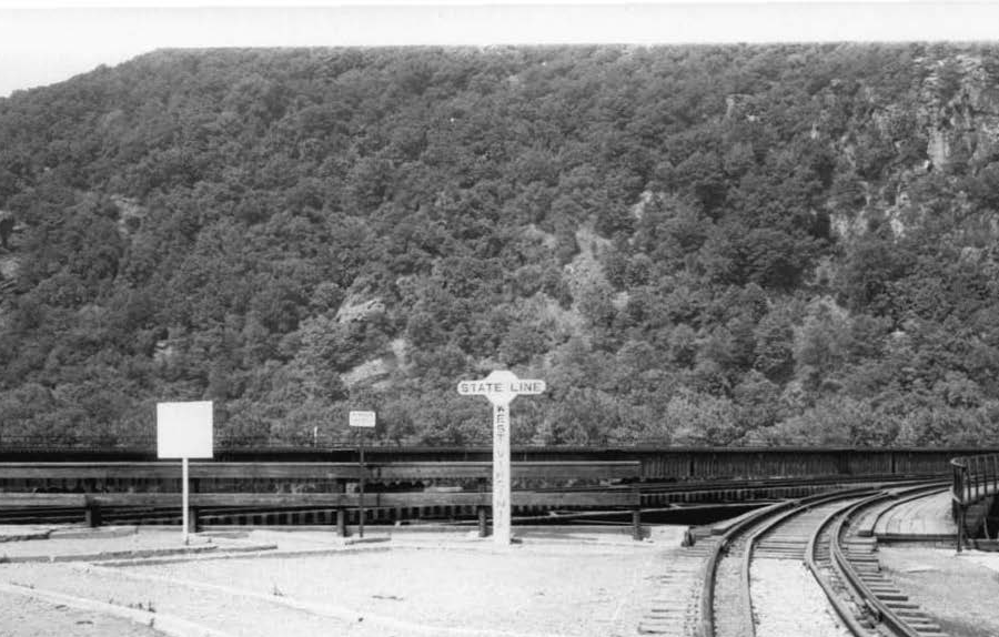
the Baltimore and Ohio (B&O) railroad bridge constructed in 1894 at Harpers Ferry had a sign showing the state boundary was on the southern edge of the Potomac River, not in the middle
Source: Maryland Historical Trust, B&O Railroad Bridge, Potomac River & Tunnel
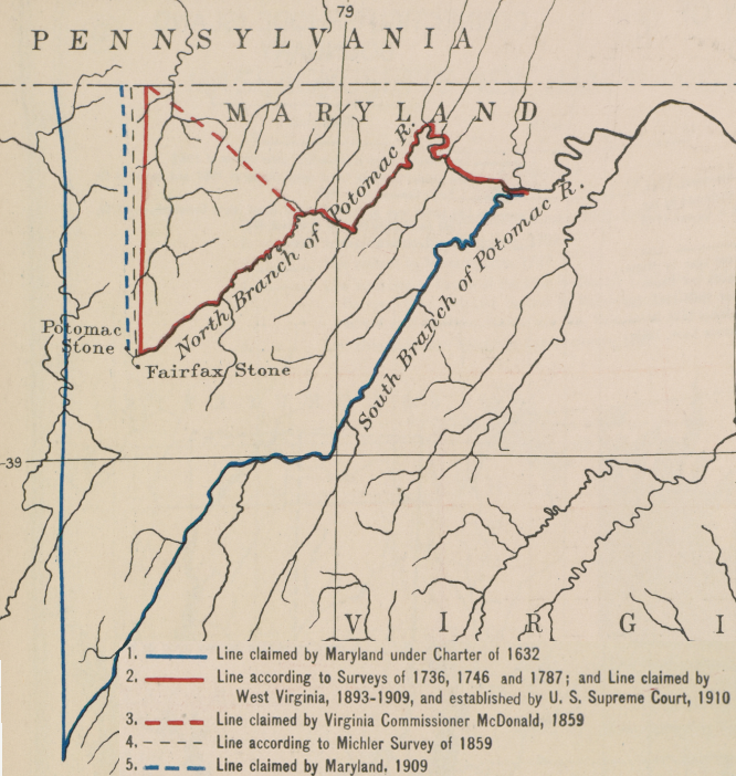
Maryland sought to define the South Branch of the Potomac River as the boundary for its 1632 charter
Source: Atlas of the Historical Geography of the United States, Western Boundary of Maryland (Plate 98a) digitized by University of Richmond