if a hurricane strikes Coastal Virginia, residents are supposed to use major roads to drive to higher ground
Source: Virginia Department of Emergency Management, Virginia Hurricane Evacuation Guide
if a hurricane strikes Coastal Virginia, residents are supposed to use major roads to drive to higher ground
Source: Virginia Department of Emergency Management, Virginia Hurricane Evacuation Guide
After Hurricane Floyd in 1999, disaster planning in Hampton Roads focused on how to evacuate people from low-lying areas and move them all the way to the Fall Line before a Class 3 storm hits. Hampton Roads residents could just move to higher ground within the region rather than flee to Ashland, Richmond, or Petersburg, but there are too few shelters on high ground for the 1.25 million people who could be affected. In Virginia Beach, the city has planned for its emergency shelters to house only 15% of the 100,000 people who might be told to evacuate.1
Coastal officials recognize that the threat from flooding further inland can be just as great as the threat from high winds and a storm surge near the Atlantic Ocean and Chesapeake Bay. Massive rainfall from Hurricane Camille in 1969 (perhaps as much as 31" in one night) led to landslides and floods in Nelson County. Over 100 people died in that Blue Ridge county, over 150 miles away from the coastline.2
When Hurricane Florence threatened to strike as a Category 4 storm in 2018, Virginia Beach officials planned to evacuate Back Bay and Sandbridge and open seven shelters to offer a place to stay within the city. The director of the city's Office of Emergency Management commented:3
Gov. Northam ended up becoming Virginia's first governor to issue a mandatory evacuation order and open state-run shelters. Until then, local governments had always been responsible for providing housing for evacuees under different circumstances, including hurricanes.
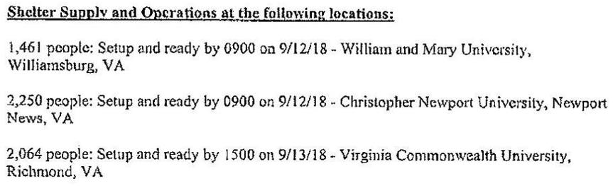
The Virginia Department of Emergency Management quickly contracted for emergency shelter housing for storm evacuees. It paid to have 5,775 beds installed at three locations, with 2,064 beds at Virginia Commonwealth University, 1,461 beds at the College of William & Mary, and 2,250 beds at Christopher Newport University.
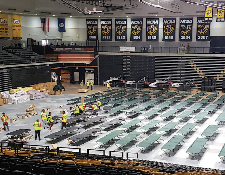

the Siegel Center at Virginia Commonwealth University was converted into an emergency shelter for Hurricane Florence evacuees
Source: SLS, Hurricane Florence Response 2018 - VDEM Emergency Shelters and Richmond Times-Dispatch, Virginia lawmakers eliminate $4M budgeted for emergency shelter supplies, ask Northam official to create new plan
The hurricane shifted its path, and just 52 people used the emergency housing established by the state at a cost of $31 million. Even after Federal reimbursement for the natural disaster, Virginia spend nearly $8 million on the housing.
The obvious alternative to last-minute, high-cost emergency contracting was to stockpile supplies in advance, plus pre-arrange contracts for a surge of showers, toilets, and other equipment for activation when needed. However, the 2019 General Assembly declined to approve funding for a hurricane stockpile until there was a new procurement plan for shelter services and supplies. The governor had requested less than $5 million, but anticipated a $30 million up-front investment would be required to prepare for a future evacuation order.
In 2014 and 2017, the Virginia Department of Emergency Management was unable to find contractors willing to commit to provide sufficient shelter capacity within 72 hours. The contract for Hurricane Florence was so expensive in part because the state required mobilization within 48 hours.
By September, 2019, the governor approved a new Commonwealth of Virginia Emergency Operations Plan (COVEOP). It was an all-hazards plan, synchronized with the Federal Emergency Management Agency's National Incident Management System. The 2020-2022 budget called for the Virginia Department of Emergency Management to inventory locations which could be used as state-run shelters.4
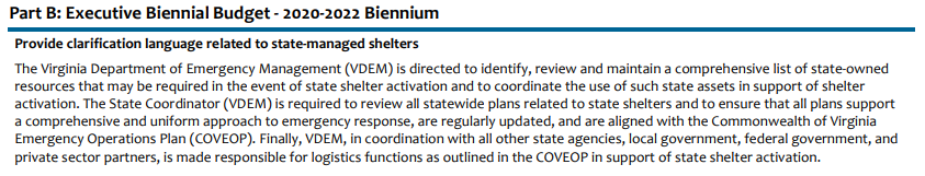
the Virginia Department of Emergency Management is responsible for an inventory of potential shelter locations
Source: Virginia Department of Planning and Budget, The 2020 Executive Budget Document
Failure to comply with a mandatory evacuation order is a misdemeanor offense, with potential punishment up to a $2,500 fine and a maximum of a year in jail. Some residents still simply refuse to move. One person in Sandbridge has re-used the same plywood to protect his windows, and has painted that plywood with the names of storms that have passed through the area while he stayed in this house. In 2018, he added Florence to a list which already included Irene, Matthew, Joaquin, and Sandy.
The Virginian-Pilot reported that half of the residents in Sandbridge consistently planned to ride out storms rather than to evacuate. That led to some blunt talk by emergency management personnel:5
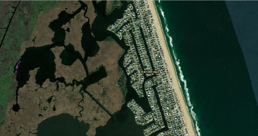
Sandbridge is one of the areas at high risk from flooding and wind damage, but some residents still refuse to evacuate
Source: ESRI, ArcGIS Online
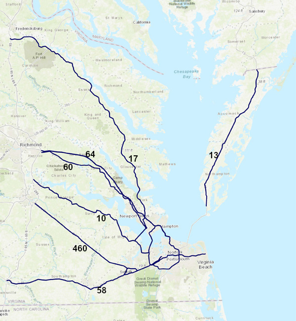
The greatest challenge for a successful evacuation is that the roads headed inland could become jammed with traffic, and people could be trapped on flooded highways when a storm arrives. The seven primary hurricane evacuation routes are designed for standard traffic patterns and not for one time, "worst case scenario" events. If many residents comply with an evacuation order, vehicle traffic will far exceed the road capacity unless residents leave different areas at different times.
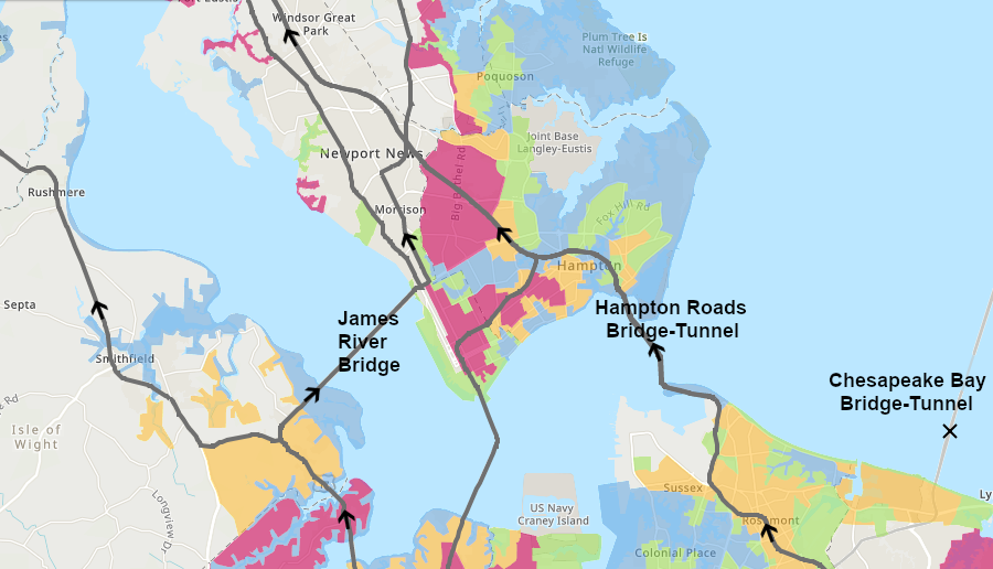
For the residents in Hampton Roads, there are three roads south of the James River (US 58, US 460, and State Route 10) which provide planned escape routes. Drivers can also cross over the James River Bridge and take US 17 north, but I-664 North is not an evacuation route. The northbound tube of the Monitor-Merrimac Memorial Bridge-Tunnel (I-664) will be closed to minimize congestion at the I-664/64 interchange in Newport News, and northbound I-664 traffic will be detoured to the James River Bridge (US 17).
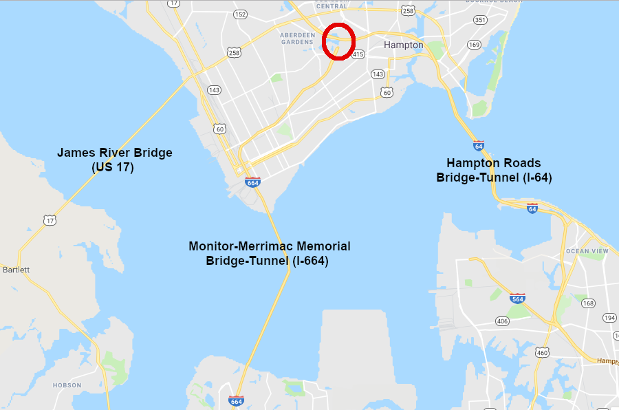
the northbound tunnel of the Monitor-Merrimac Memorial Bridge-Tunnel (I-664) will be closed to avoid congestion at the I-664/I-64 interchange (red circle)
Source: GoogleMaps
Primary evacuation routes north of the river are US 60 and I-64 (including the High Occupancy Toll lanes) on the Peninsula, plus US 17 headed north across the Rappahannock River at Yorktown. On the Eastern Shore, US 13 provides a route to flee north towards Accomack County and Salisbury, Maryland, if a storm makes landfall south of the Chesapeake Bay.
Only people already on the Eastern Shore are supposed to use US 13. Norfolk and Virginia Beach residents living near the south end of the Chesapeake Bay Bridge-Tunnel are not supposed to drive north on US 13 in order to cross the mouth of the Chesapeake Bay via the bridge-tunnel and reach the Eastern Shore. Instead, they are directed to flee westward via the Hampton Roads Bridge-Tunnel and to follow I-64 inland.
The Chesapeake Bay Bridge-Tunnel restricts crossing by large vehicles once winds reach 40 miles per hour. Once winds reach 65 miles per hour, only cars are allowed to use the facility. Once hurricane gusts approach that speed, the Chesapeake Bay Bridge-Tunnel could be closed.
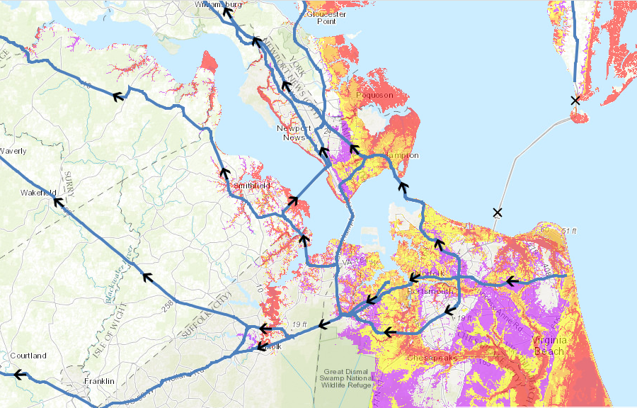
Hampton Roads evacuation routes in 2014 assumed the Chesapeake Bay Bridge-Tunnel will be closed and no one should flee to the Eastern Shore
Source: Virginia Department of Emergency Management, Virginia Hurricane Storm Surge Tool
Residents living in southern Virginia Beach and most of Norfolk are supposed to use US 58, US 460, and State Route 10 to flee to higher ground near the Fall Line. Virginia Beach residents living north of I-264 and Norfolk residents who live east of I-64 are supposed to drive through the Hampton Roads Bridge-Tunnel, then stay on the interstate highway and drive westward towards Richmond.
in 2017, state officials assumed some residents in South Hampton Roads would cross the James River Bridge and drive west on the Peninsula
Source: Virginia Department of Emergency Management, Virginia Hurricane Evacuation Zone Lookup Tool
Evacuation plans assume that residents living on the Peninsula will use US 60 and I-64 to drive west towards Richmond, or US 17 to go north towards Fredericksburg.6
In the first plans developed after Hurricane Floyd, Virginia officials had planned for personnel at Langley Air Force Base in Hampton to drive south on Route 17 over the James River Bridge, and then head west to Fort Pickett. The James River Bridge is now viewed as an escape route to the north as well. South Hampton Roads residents can drive across the bridge to access US 60 and I-64 on the Peninsula, while at the same time residents in Newport News might be driving south across the James River to Isle of Wight County.
Evacuation plans for what is now Joint Base Langley-Eustis have been revised as well. When Hurricane Florence threatened Hampton Roads in 2018, military officials authorized travel to any safe haven location within 750 miles of Joint Base Langley-Eustis. The jets were flown out to Rickenbacker Air National Guard Base in Ohio.7
Source:
Virginia Department of Emergency Management, Virginia Hurricane Evacuation: I-64 Lane Reversal
The evacuation plan assumes a wave of people can move out of the danger zone in time, if people leave at staggered times rather than all at once. To double the capacity of I-64 to handle extra traffic, the governor can order that the normal direction of vehicles using the eastbound lanes be reversed to allow for "contraflow" traffic. A lane reversal is most likely to be ordered if a Class 4 hurricane is expected to hit Hampton Roads.
Once the governor declares that evacuation is required, ramps that normally provide access to the eastbound lanes leading towards Norfolk will be blocked and state police will ensure all westbound traffic is out of those lanes. During the evacuation, all vehicles on I-64 will travel westbound-only from the Hampton Roads Bridge-Tunnel to Exit 200 (I-295).
Traffic will move into the reversed lanes at only one location, in Norfolk. All traffic headed west from South Hampton Roads will cross over at Mile Marker 273, south of Willoughby Spit and east of the Hampton Roads Bridge-Tunnel. That westbound contraflow traffic will use the normally eastbound tube of the bridge-tunnel to get to the Peninsula. Other vehicles will be able to access the standard westbound lanes at the 4th View ramp and use the westbound tube, then stay in the standard westbound lanes though Hampton, Newport News and York County.
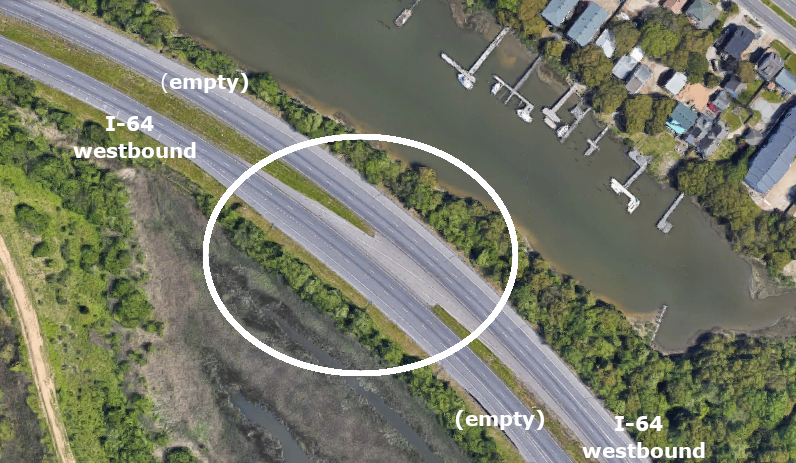
on I-64 just south of Willoughby Spit, pavement is in place for switching all westbound traffic to the reversed lanes before using the Hampton Roads Bridge-Tunnel
Source: GoogleMaps
The contraflow drivers will have the opportunity to get off I-64 at Williamsburg (Exit 234) and Bottoms Bridge (Exit 205) to get gas, food, or a rest stop. At Exit 200 (I-295), all vehicles on the normal westbound I-64 lanes will have to exit onto I-295, clearing those lanes of traffic. The contraflow drivers in the reversed lanes will cross over the median and end up in the normal westbound lanes, where drivers will continue westward on I-64 towards Richmond. Any driver in the contraflow lanes who wants to exit onto I-295 will have to exit I-64 at Bottoms Bridge and re-enter using the normal westbound lanes.
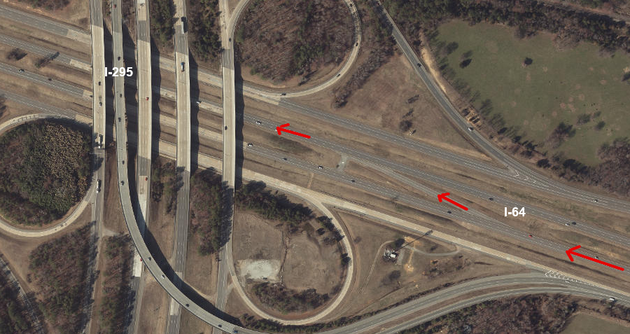
traffic in the normal westbound lanes on I-64 will exit onto I-295, then contraflow traffic will use a crossover to shift to those westbound lanes
Source: ESRI, ArcGIS Online
On the Peninsula, vehicles in all I-64 lanes will be westbound until reaching I-295. Drivers will be able to use the New Kent Rest Area and return to the contraflow (normally eastbound) lanes. Vehicles who exit the contraflow lanes at Williamsburg (Exit 234) or Bottoms Bridge (Exit 205) to fill up with gas or empty out at restrooms will be able to access I-64 again, but only by using the normal westbound lanes where traffic congestion may be greater.
Before reversing the I-64 lanes and initiating contraflow for 73 miles of I-64, the Virginia Department of Transportation originally planned to have employees drive to each I-64 interchange and install portable barriers on ramps. In 2006-2007, 440 gates were installed at the entrance ramps so the lane reversal process could be completed within six hours.8
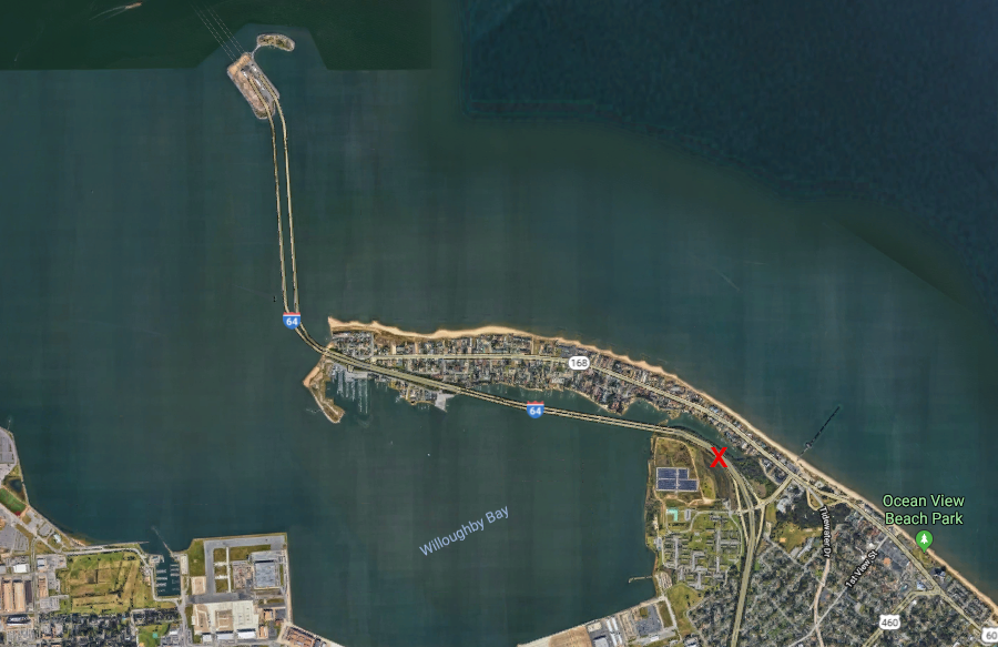
traffic headed westward on I-64 from South Hampton Roads will cross over to the normally east-bound lanes at Mile Marker 273 (red X), before entering the Hampton Roads Bridge-Tunnel
Source: GoogleMaps
At that time, the state's evacuation plan assumed 36 hours would be required for everyone to get to higher ground. Critics had noted:9
In 2014, state emergency management professionals felt more confident about the National Weather Service's ability to predict the path of strong storms, and thus avoid premature evacuation orders. Meteorologists using better computer models could provide a more-accurate assessment of the expected path and speed of hurricanes. Greater predictability of the path of a storm allowed a revision of plans. The governor could order an evacuation to be started earlier with less chance of a false alarm that would disrupt normal living and business activity, and be politically embarrassing.
Until 2014, state officials had planned to wait until 38 hours before a storm was predicted to arrive before ordering a mandatory evacuation. In 2014, they extended that timeframe to start evacuations 48 hours before storm arrival.10
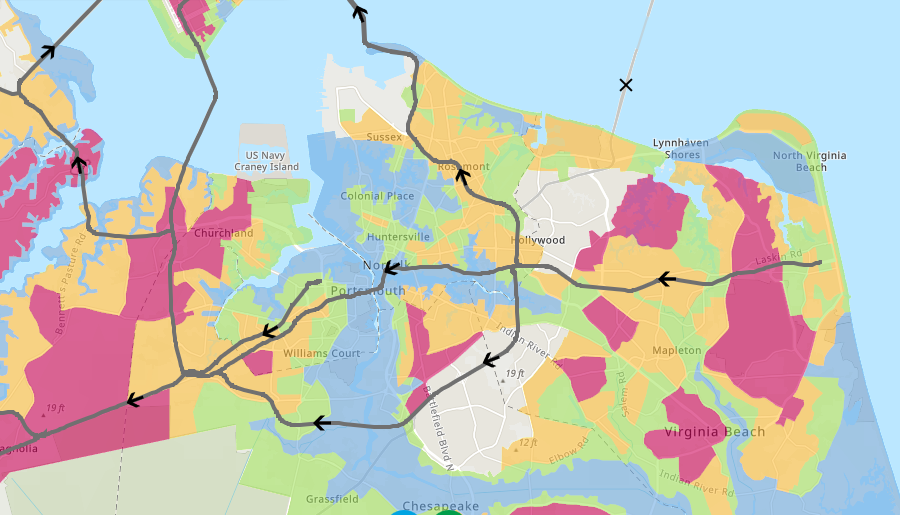
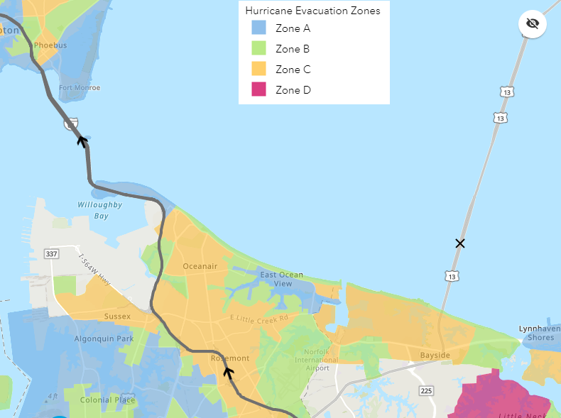
Evacuation planning was simplified and standardized three years later in 2017. The Virginia Department of Emergency Management defined four separate evacuation zones (A, B, C, and D) that applied to 23 separate jurisdictions in Hampton, the Middle Peninsula, Eastern Shore, and Northern Neck. A color-coded Know Your Zone map allows residents to identify when their specific neighborhood has been advised to evacuate.
The 2017 revision was completed after:11
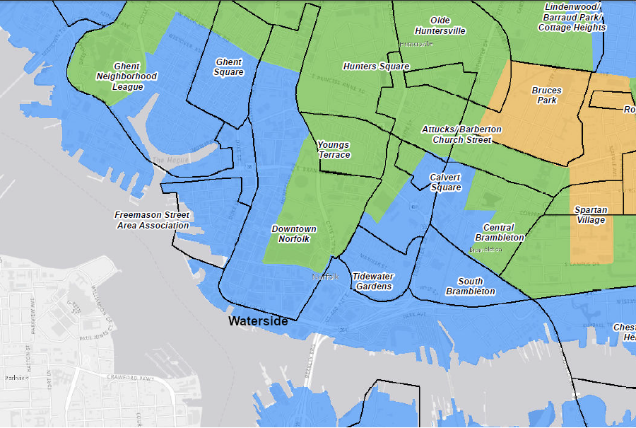
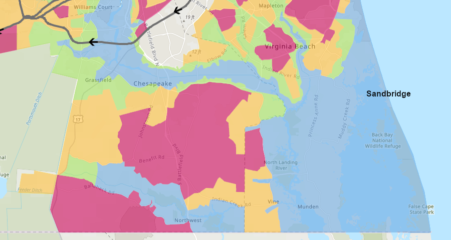
Norfolk's Waterside District on the Elizabeth River is in Zone A, the first to be evacuated
Source: City of Norfolk, Hurricane Evacuation Zones
Zone A, colored blue on the Know Your Zone map, includes the topographically-low areas of highest risk that will be evacuated first. Zone B (green) and Zone C (orange) are higher lands, and progressively less at risk.
Zone D is colored red, and includes the acreage that is least likely to need to be evacuated. The highest ground, where no evacuations are planned, is not color-coded. The uncolored area is where some of those having to evacuate may choose to go, perhaps by taking advantage of rental services such as Airbnb to find an less-convenient-but-safer place for a night or three.
the 2017 evacuation planning created four color-coded zones, with blue defining the area of greatest risk to be evacuated first
Source: Virginia Department of Emergency Management, Virginia Hurricane Evacuation Zone Lookup Tool ("Know Your Zone" map)
One major challenge for emergency management officials is still determining when to order a mass evacuation. The path of a storm changes and the disruption of an evacuation is significant, so there is a natural desire to wait until weather forecasters are confident about a storm track.
In September, 2018, Hurricane Florence was predicted to reach landfall near the Chesapeake Bay as a Class 3 or even Class 4 storm. The slow-moving system was expected to produce two feet of rain, in addition to the storm surge.
Governor Northam ordered a mandatory evacuation of the 245,000 people living in Zone A. It was the first time a governor based an evacuation order on the "Know Your Zone" designations in Hampton Roads, and the process was complicated when the state's website hosting the Know Your Zone maps crashed. Though the threat of the hurricane was high, state preparations were still measured. Governor Northam did not order a lane reversal on I-64, and winds never reached high enough speeds to justify closure of any bridges or tunnels.
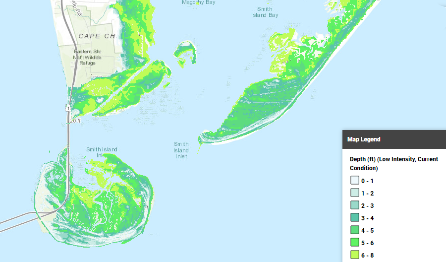
the storm surge from a Class 1 hurricane might not cover Route 13 in Northampton County, but emergency planners assume the Chesapeake Bay Bridge-Tunnel will be closed due to high winds
Source: Coastal Resilience, Virginia Eastern Shore
The state arranged for shelters with food and showers for 5,775 storm refugees, for at least seven days. Shelters opened to the public at Christopher Newport University (for 2,250 people) and the College of William and Mary (for nearly 1,500 people). The shelter at Virginia Commonwealth University (for 2,000 people) was prepared, but never opened after the storm path changed.
Local jurisdictions closed schools, suspended garbage collection, and also opened their own shelters for people unable/unwilling to drive inland.
In recognition that some people will not leave their homes if that requires abandoning their cats and dogs, localities designated pet-friendly shelters for people leaving Zone A. The various shelters were not planned to accommodate everyone directed to flee by the governor's order. There were 19,000 housing units affected in Hampton, but the city opened only two shelters.
Northampton County does not open emergency shelters; instead, it directs people to Nandua High School eight miles north in Accomack County.12
Hampton Roads jurisdictions and Accomack County opened shelters in advance of the predicted arrival of Hurricane Florence in 2018
Source: ESRI, ArcGIS Online
The predicted rainfall and massive flooding came true, but after the storm moved south. Eastern North Carolina caught the brunt of the impacts and Hampton Roads was only marginally affected by wind and water.
The evacuation order still disrupted the tourism business and normal life. In Norfolk, the Waterside District was shut down for two days. Particularly in Virginia Beach, businesses closed because workers and customers had fled town.
State officials estimated that preparations for Hurricane Florence would cost $60 million, most of which were expected to be reimbursed by the Federal government. Roughly half of that cost was for the three state-funded shelters, which cost $10 million each. They were contracted out to a Texas company that provides disaster services, after state officials determined that Virginia-based companies were unable to provide the needed emergency services. The other major cost was $20 million to mobilize two urban search and rescue teams.
Members of the Senate Finance Committee made clear that the costs were "shocking," and questioned if contractors were "gouging" the state. The Secretary of Finance explained that Hurricane Florence was the first time Virginia officials had implemented the emergency management plan to mandate evacuation and establish shelters. Emergency officials wanted shelters set up within 36 hours, and the company already under contract with the state required 72 hours.
75% of the state's public response costs were reimbursed by the Federal Emergency Management Administration, after President Trump approved declaration of a major disaster for Hurricane Florence in Virginia. Still, one legislator stated bluntly:13
in 2018, state officials committed over $30 million for a contractor to provide shelters and feed 5,775 people evacuating from Hampton Roads
Source: Richmond Times-Dispatch
For Hurricane Florence in 2018, evacuation ended up not being necessary. The combination of imprecise weather predictions, plus the long time required to move people from danger, forces emergency managers to make decisions that may disrupt normal routines and not be followed by an actual disaster. After Hurricane Florence bypassed Hampton Roads, the state coordinator of emergency management commented:14
all of Sandbridge is designated Zone A, and a future storm surge could end up drowning those who choose not to evacuate
Source: Virginia Department of Emergency Management, Virginia Hurricane Evacuation Zone Lookup Tool ("Know Your Zone" map)
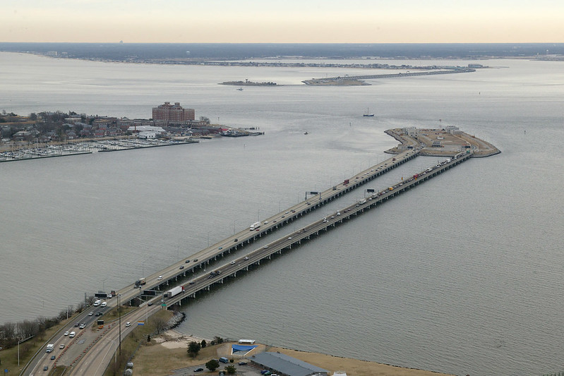
the Hampton Roads Bridge-Tunnel is a chokepoint for evacuating Norfolk/Virginia Beach residents in advance of a hurricane
Source: Virginia Department of Transportation, Hampton Roads Bridge-Tunnel
none of the people evacuating from the four color-coded zones in Norfolk/Virginia Beach should use the Chesapeake Bay Bridge-Tunnel because high winds make it dangerous
Source: Virginia Department of Emergency Management, Virginia Hurricane Evacuation Zone Lookup Tool ("Know Your Zone" map)
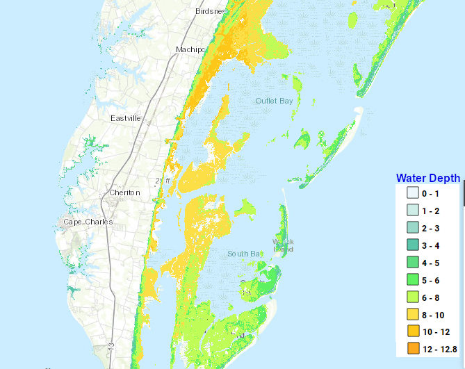
if a 12' high storm surge floods much of Northampton County, residents are supposed to flee north towards Salisbury, Maryland
Source: Coastal Resilience, Virginia Eastern Shore