Limestone in Virginia
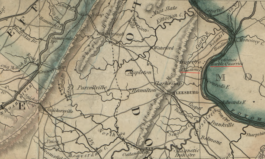
the limestone deposits in Loudoun County were mined primarily for agricultural lime prior to the Civil War
Source: Library of Congress, A map of the state of Virginia, constructed in conformity to law from the late surveys authorized by the legislature and other original and authentic documents (1859)
Calcium carbonate crystals (CaCO3) have been deposited multiple times when oceans and lakes covered what is now Virginia. Today the state has different types of rocks rich in calcium carbonate, including limestone, dolomite, marl, marble and travertine.
The first major limestone deposits on Earth formed on the bottom of the original oceans, as carbon dioxide (CO2) from underwater volcanoes and in the atmosphere was absorbed into the water. That carbon dioxide combined with dissolved ions of calcium (Ca2+) already in the ocean. Supersaturated calcium carbonate crystals (CaCO3) eventually precipitated as limestone onto the bottom of the ocean floor.
Dolomite, a calcium-magnesium carbonate with a chemical formula of CaMg(CO3)2, developed as magnesium and calcium atoms aligned with carbonate molecules (CO3) in orderly rows on the edge of growing crystal surfaces. Dolomite appears to have formed when tides or currents swept regularly across the carbonate crystals. The water dissolved calcium and magnesium ions which had not aligned consistently, allowing dolomite crystals to grow in consistent layers.1
The earth's atmosphere and oceans have maintained an equilibrium that sequestered carbon in limestone and dolomite. In contrast, once-similar Mars had an atmosphere with a higher percentage of sulfur. When sulfur was dissolved in the oceans that once existed on Mars, the resulting sulfuric acid prevented the precipitation of limestone and dolomite. Rovers sent to Mars are finding sulfur-rich minerals in the places where water once existed. In contrast, Earth's oceans are coated in calcium-rich minerals.2
Some of the oldest limestone in Virginia is derived from sediments deposited after the supercontinent Rodinia formed about a billion years ago. What today is called the "Grenville basement" bedrock was created as chunks of continental crust were pushed together. Later, calcium carbonate (CaCO2) precipitated out of lakes on top of the basement bedrock. Some of the earliest forms of algae may have secreted the CaCO2.
During or after a failed rifting event 750 million years ago, volcanic eruptions and eroding sediments created the formations found today around Mount Rogers. Heat from the vulcanism metamorphosed limestone-rich sediments. There is marble within the Alligator Back formation near Lynchburg as well.
Local tradition holds that a block of stone from a quarry in Grayson County near Troutdale was used in the construction of Grant's Tomb.3
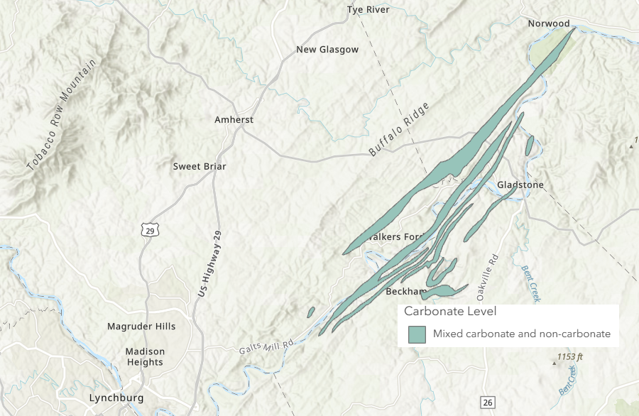
there are units with Cambrian/Precambrian marble within the Alligator Back formation near Lynchburg
Source: Virginia Energy, DGMR/Carbonate Rock (MapServer)
When Rodinia finally broke up, basalt lava erupted through cracks in the thinning crust. Lava reached the surface 550-570 million years ago and coated what is now exposed as the Blue Ridge. That lava flowed on top of older sediments which geologists call the Swift Run Formation, as well as the billion-year old Grenville basement rock underneath those sediments. The 550-570 million year old lava is known today as the Catoctin Formation.
Heat from the Catoctin basalt metamorphosed the calcium carbonate deposited on the bottom of lakes. The heat altering the crystal structure and converted limestone into marble. The marble found today within the Swift Run formation on the Blue Ridge is in discontinuous thin beds less than three meters thick. That pattern is the basis for assuming the original deposition of the limestone (before metamorphism into marble) was in separate lakes, rather than in a continuous layer underneath the ocean on the edge of the continent.4
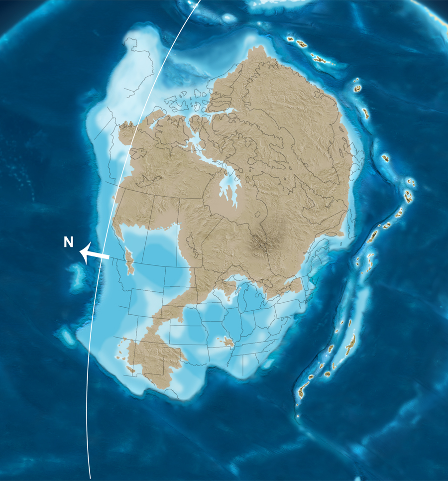
About 500 million years ago during the Cambrian Period, after the Catoctin basalt stopped flowing, the chunk of continental crust which includes modern Virginia was south of the Equator. "Virginia" was on the edge of the Iapetus Ocean, in a part known as the Sauk Sea.
Coral reefs grew in the warm waters. Zooplankton and larger forms of life protected by shells thrived in the Sauk Sea. When they died and sank to the bottom, deposits of limestone (and magnesium-rich dolomite) gradually accumulated in sedimentary layers. The calcium-rich sediments were gradually buried below the sands and cobbles deposited by freshwater rivers and in saltwater embayments.
As conditions in the ocean changed, the chemistry and alignment of crystals varied. Dolostone/dolomite (limestone with a high percentage of magnesium along with calcium) also formed on the continental shelf. Geologists map different formations of limestone/dolomite based on those differences.
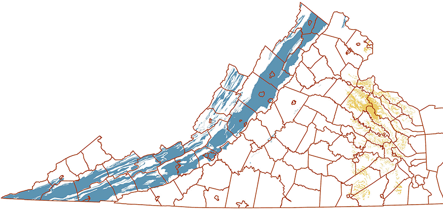
Those limestone/dolomite layers are now exposed on the floor of different valleys in the Valley and Ridge physiographic province. They are the common bedrock in the Shenandoah Valley, in the Roanoke Valley, in the New River Valley, and in the valleys of the Tennessee River's upper tributaries (Holston, Clinch, and Powell rivers).. Limestone outcrops in farm fields are readily visible from Interstate 81, which crosses that province from the Shenandoah Valley in the north to the Tennessee border.
Tectonic forces in the Taconic, Neo-Acadian, and Alleghenian orogenies interrupted the deposition of limestone and uplifted mountains. Erosion from the mountains buried limestone sediments, but the heat/pressure was not sufficient to transform the crystal structure of the calcium carbonate molecules and metamorphose them into marble.5
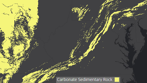
nearly all limestone exposed at the surface in Virginia today was deposited in the Iapetus Ocean, before the addition of the land between the Blue Ridge and Atlantic Ocean
Source: ESRI, Ecological Tapestry of the World
Tectonic forces moved chunks of continental crust and closed the Iapetus Ocean to create the supercontinent of Pangea about 300 million years ago. For 100 million years until Pangea broke apart, the bedrock of modern Virginia was in the middle of a massive land mass without ocean sediments being deposited nearby.
New continental crust, terranes from island arcs, were pushed against the edge of Virginia in the Taconic, Acadian, and Alleghenian orogenies. The island arcs widened the crust over the last 400 million years to create the Piedmont and Coastal Plain physiographic provinces. Carbonate layers that were once at the bottom of the Sauk Sea, and on the edge of Rodinia, are now far from the modern Atlantic Ocean shoreline.
The Taconic, Acadian, and Alleghenian orogenies narrowed the chunk of continental crust known as Laurentia, as well as widened it by accreting new terranes. Tectonic collisions squeezed the sedimentary layers that had originally been deposited on the floor of the Sauk Sea. Those layers cracked and slices were thrust upwards on ramps of softer shales.
Limestone formations were shoved on top of other layers. What had originally been aligned in flat layers, like bricks in a sidewalk, ended up stacked like pancakes. As a result, the continent contracted in width and expanded in height as Pangea formed.
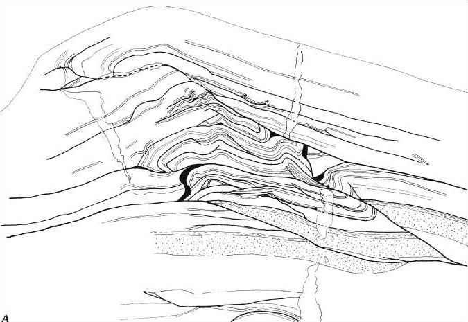
tectonic forces during orogenies cracked sedimentary layers at weak zones and slid layers of limestone on top on one another, like a stack of pancakes
Source: US Geological Survey (USGS), Lateral Ramps in the Folded Appalachians and in Overthrust Belts Worldwide - A Fundamental Element of Thrust-Belt Architecture (Figure 4A)
More than limestone layers were thrust upwards and westwards by the Alleghenian orogeny. One large slice of the Grenville basement, deep underneath the Sauk Sea sediments and on what had become the western edge of the accreted terranes, was broken off and uplifted. That slice of crust, today's Blue Ridge, was shoved up and pushed 40 miles to the west.
The Grenville basement slice, the billion year old Blue Ridge, ended up on top of the much younger (500-350 million year old) limestone/dolomite layers. Faults on the eastern and western edges of the Blue Ridge identify the slice of igneous bedrock that was thrust westward. Underneath that slice are the remains of limestone sediments deposited in the Sauk Sea, transformed in the process of the emplacement of the Blue Ridge.
Deposition of limestone started again along Virginia's new shoreline about 200 million years ago, after the breakup of Pangea and the formation of the Atlantic Ocean. Those sediments deposited on the Piedmont have eroded away, but sediments from the Cretaceous Period are exposed at the Fall Line and buried underneath the Coastal Plain.
Shells deposited in Coastal Plain formations during the Miocene and Pliocene epochs, within the last 25 million years, have created calcium-rich layers east of the Fall Line. In some places, the calcium in the shells has dissolved and the surface has collapsed, creating sinkholes.
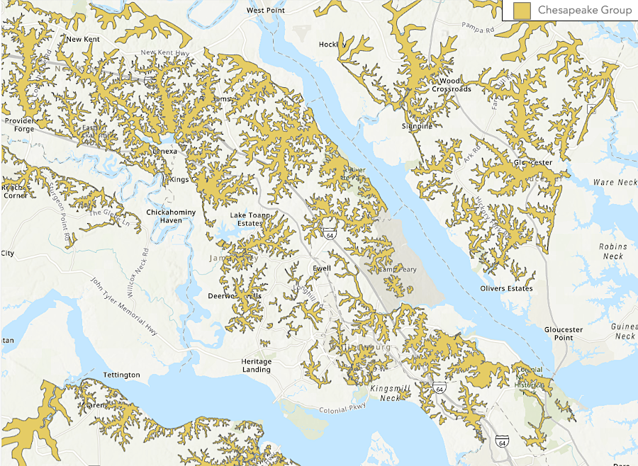
sinkholes form in the Coastal Plain where calcium-rich bedrock in Chesapeake Group sedimentary formations has dissolved
Source: Virginia Energy, Sinkholes and Karst; DGMR/CarbonateRock (MapServer)
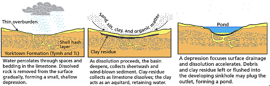
The National Park Service has identified karst topography at Colonial National Historical Park, which links Jamestown with Yorktown. Components of the Yorktown Formation on the Coastal Plain are rich in fossils of coquina shells; "shell hash" beds are as much as 70 feet thick. Enough calcium in them has dissolved and transported away by groundwater to create sinkhole depressions at the surface that resemble Revolutionary War battlefield fortifications.
General Charles Cornwallis supposedly hid in a "cave" during the 1781 battle at Yorktown. That cave had originally been excavated by colonists for storage and was not a natural feature. Depressions at the surface nearby are sinkholes, created as fossil shells have dissolved and clay/sand sediments filled the resulting voids.
Brackens Pond on the Colonial Parkway is a perennially wet sinkhole. So is Grafton Pond near Newport News, but many of the 100 other sinkhole ponds nearby are seasonally wet vernal pools.
sinkholes and karst ponds form in the Yorktown Formation on the Coastal Plain
Source: National Park Service, Geologic Resources Inventory Report, Colonial National Historical Park
Marl accumulations in the Coastal Plain were mined for fertilizer in colonial times, and for a flux in blast furnaces smelting iron. In the 1900's, marl near Suffolk was mined for production of cement.
Starting with settlers at Jamestown, oyster shells were heated ("burned") to create powdered lime for production of plaster and mortar. Remains of post-Revolutionary War lime kilns are at Leesburg and near Blacksburg, but archeologists have not identified any lime kilns dating from the colonial period. Early locations for burning lime may have been simple pits in the ground filled with wood and layers of shells, leaving little evidence other than a thin rim of scorched clay.
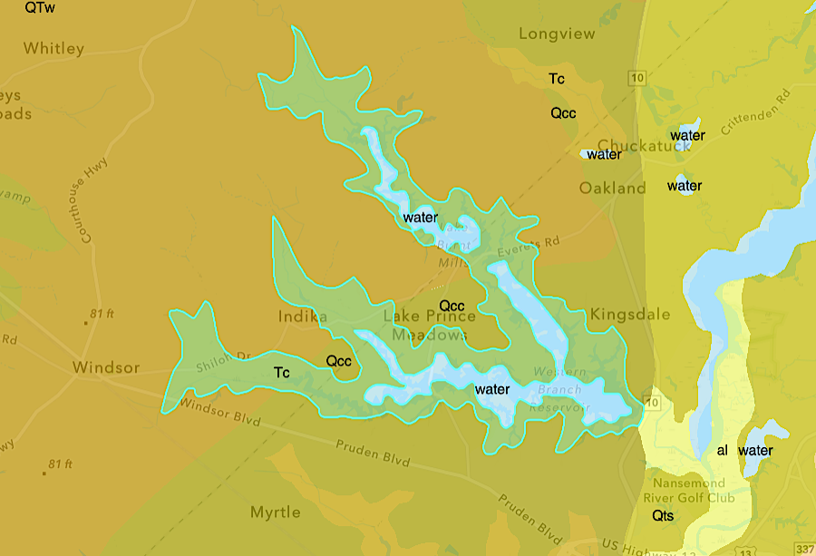
enough marl was mined out of Chesapeake Formation sediments near Suffolk to create a series of lakes
Source: Virginia Energy, Geology and Mineral Resources
Nearly all commercial limestone production comes from quarries west of the Blue Ridge. Some of the large limestone quarries today crush what they excavate to produce agricultural lime, but most limestone quarries sell crushed stone for construction of roads and buildings.
In addition to serving as gravel, foundation stones, and facing stone on the exterior of buildings, some quarried limestone is pulverized to create wallboard and cement. Cement is 10-15% of concrete, "the most abundant manufactured material on the planet." Cement is the essential ingredient which glues together the sand and aggregate particles.
Virginia's only remaining cement manufacturer is the Roanoke Cement Company. It has a quarry and adjacent processing plant located near Tinker's Cliffs in Bedford County. The company excavates raw material from the Moccasin Formation, which was deposited in the Ordovician Period over 450 million years ago before land plants had spread across the continents.6
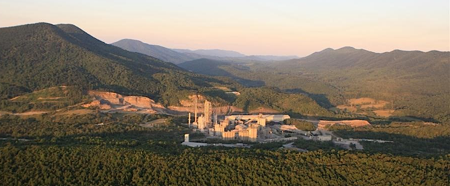
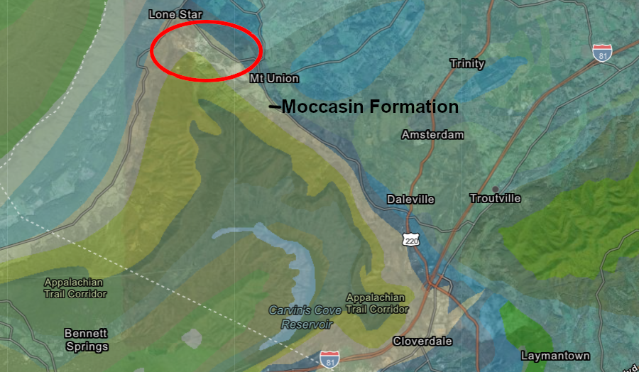
Roanoke Cement Company, Virginia's only active cement plant, converts rock over 450 million years old into cement
Source: PW Newswire, Roanoke Cement Company Honored by EPA's Energy Star Program for 11th Straight Year (July 27, 2017) and Virginia Department of Energy, Geology Mineral Resources
Limestone is still used as a building stone; many government buildings such as the US Capital have a limestone exterior. As far back as the mid-1700's, Shenandoah Valley residents used limestone blocks to build fortified houses that offered protection against Shawnee, Seneca, and Cherokee raids. Courthouses and other public buildings west of the Blue Ridge are often made of limestone, in contrast to the brick courthouses east of the Blue Ridge and the buildings such as the Rotunda at the University of Virginia in Charlottesville.
The standard architecture for buildings at Virginia Tech relies upon dolomite quarries near Blacksburg that supply "Hokie Stone." That rock is used for exterior walls of buildings on campus. Hokie Stone is a dolostone from the Chepultepec Formation deposited roughly 480 million years ago.7

Virginia Tech uses dolomite known as "Hokie stone" to clad nearly all of its building on the campus at Blacksburg
Railroads haul crushed limestone from the Shenandoah Valley east through the Blue Ridge and use the gravel as ballast to support the track beds. East of Thoroughfare Gap, where the exposed bedrock is red sandstone or black basalt, railroad tracks are placed on top of the grey limestone gravel. The grey ballast with white streaks of calcite appears out of place in the iron-rich reddish bedrock of the Culpeper Basin.
There are a few outcrops of limestone east of the Blue Ridge.
Thomas Jefferson purchased four acres of "limestone land" in 1771 and 1773 for production of mortar, which was needed to build his mansion house. The lime-based mortar was used between the bricks to cement them into weight-bearing walls, and to coat the columns on the West Front that appear on the nickel coin. Limestone Creek that flows into the Rivanna River in Albemarle County, five miles southeast of Monticello.
Lime produced from the Everona Member of the True Blue Formation was also used to make the mortar required to build the brick structures at the University of Virginia. The layer of limestone is 1,000' thick at Limestone Creek, in the trough of the Everona Syncline. The sediments were deposited on top of the Catoctin Formation, probably sometime during the Cambrian Period.8
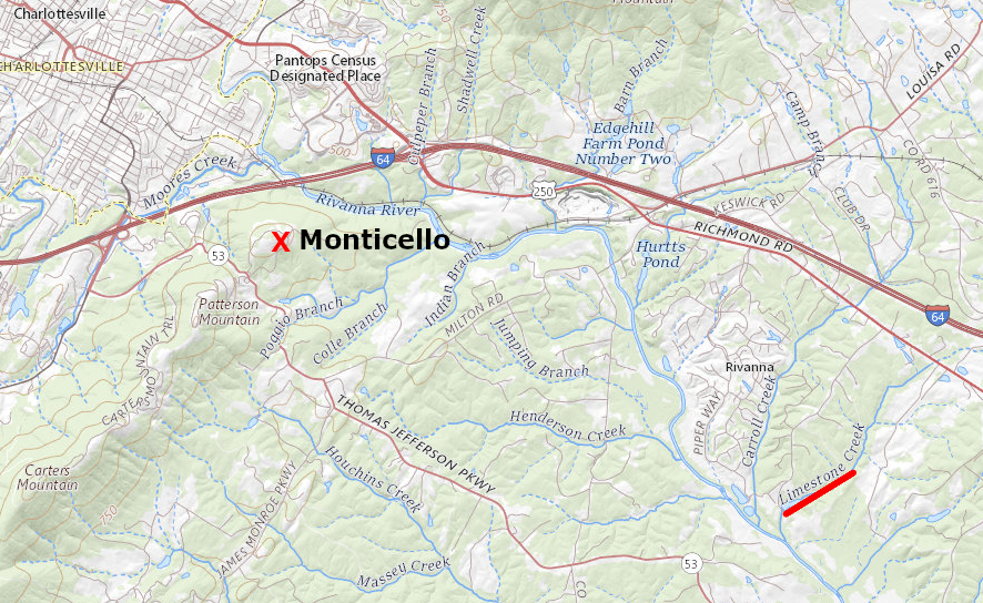
Jefferson bought a quarry on Limestone Creek, to obtain lime from the Everona Member for building Monticello
Source: US Geological Survey (USGS), The National Map
Orange County has identified the Everona Limestone as "one of the County’s greatest groundwater assets," and mapped it as part of the Groundwater Protection Zone.9

the Orange County Comprehensive Plan identifies the Everona Limestone, in the trough between two slices of the Blue Ridge, as a potential source of groundwater
Source: Orange County, 2013 Comprehensive Plan (p.81)
Limestone in Virginia is crushed for both agricultural use as a fertilizer, and for a variety of industrial uses. Underground coal mines spray a slurry with limestone on their walls, to reduce methane emissions which could become explosive. The decline in underground coal mining, as natural gas became less expensive after fracking increased supply, led to a layoff at the Carmeuse Lime and Stone quarry outside of Strasburg. The quarry was located far from the coal mines, but had developed a successful business selling "rock dust" to increase safety underground. As coal-fired power plants closed, demand for the limestone powder declined along with the demand for coal.10
In 2019 the Clorox Company, which sold Fresh Step cat litter, wanted to build a manufacturing facility next to the Carmeuse quarry in Strasburg. Frederick County was an attractive site for the business because of local labor availability and wages, and the particular site was preferred because limestone is a key ingredient in cat litter. A conveyor belt was planned to transport the raw limestone excavated from the quarry to the plant, and the final product would be transported via the adjacent Norfolk Southern railroad.
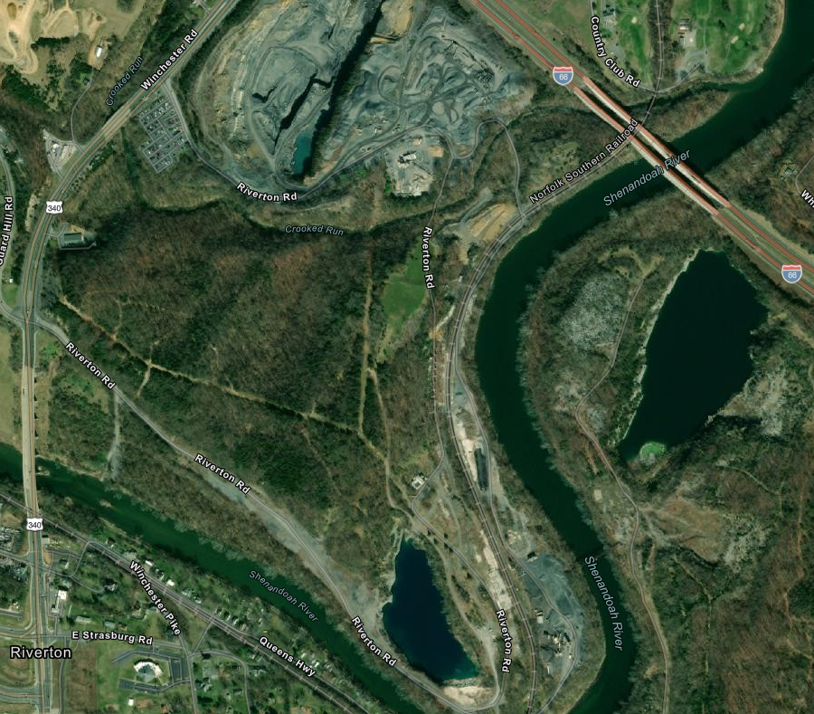
active and abandoned limestone quarries are located at Front Royal on the Shenandoah River
Source: ESRI, ArcGIS Online
Frederick County supervisors rejected a rezoning proposal on 146 acres that was needed for construction of the cat litter plant, despite the potential addition of 100 jobs and $500,000 annually in tax revenue. Residents on Brucetown Road objected to the anticipated truck traffic on a road with already was rated with a Level of Service of "F" by the Virginia Department of Transportation. The Clear Brook quarry had at least a 15-year supply of limestone, but supervisors were concerned that eventually the limestone might be trucked via Brucetown Road to the cat litter plant.11
In 2023, the Frederick County Board of Supervisors did approve in a 5-2 vote a rezoning for Carmeuse Lime and Stone to open a new limestone quarry. It was planned on 392 acres, slightly over a mile away from the existing quarry. People living near the site objected to anticipated blasting, lowering of the water table, and increased truck traffic. Impacts would begin in 8-15 years, as supply of accessible stone at the existing quarry was exhausted.
One neighbor objecting to the rezoning testified:12
- ...studies show property values decrease 25 to 30% on land up to several miles away from active quarries. If the rezoning is allowed, think about how that will affect landowners whose property is adjoined to the land zoned for extractive mining. They thought they bought land in a nice rural setting.
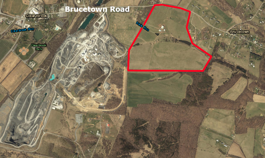
the Clorox cat litter plant would have been located on 146 acres (red polygon) near the Carmeuse quarry in Frederick County
Source: ESRI, ArcGIS Online
Underground mining extracts limestone in Giles County. Virginia Tech uses the mine for its Kimballton Underground Research Facility. The physics department has facilities on the surface, plus two underground at different levels at which cosmic rays are attenuated due to the density of limestone. The limestone has little radioactive material, so it emits few gamma photons and neutrons that might interfere with the sensitive measurements of neutrinos, muons, and other subatomic particles that penetrate deep underground.13
In 2022, a cave-in engulfed and killed an equipment operator mining the limestone.
The limestone was burned in kilns at the surface (driving off the water in the hydrated calcium carbonate molecules) before being shipped via the Norfolk Southern railroad to steelmaking plants. Excessive sulfur dioxide emissions caused the Virginia Air Quality Control Board to place Kimballton Plant No. 1 on the air pollution non-attainment list. When listed in 2022, the kilns became the only industrial facility in the state on that list.14
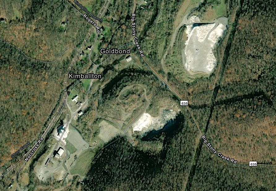
the Kimballton mine in Giles County is underground, with kilns which burn the limestone visible on the surface
Source: ESRI, ArcGIS Online
The geologic process of limestone formation continues today. Calcium carbonate is being deposited constantly on the Continental Shelf east of the Eastern Shore and Virginia Beach, at the edge of the North American continent. Modern deposition mimics the creation of the limestone formations 500-350 million years ago underneath the Iapetus Ocean, on the edge of the supercontinent Rodinia.
All of Virginia's tourist caves have been etched out naturally within limestone that was deposited 570-350 million years ago on the continental shelf of the Iapetus Ocean. The caves themselves are much younger than the bedrock in which they are located.
Various types of cave formations, primarily stalactites and stalagmites, evolved as calcium carbonate dissolved in groundwater has crystalized. The youngest limestone in Virginia solidified in the last second, when a drip of water evaporated at the end of a "soda straw" formation somewhere in a Virginia cave. Evaporation deposited a tiny addition to that straw.
Today the Atlantic Ocean is on the edge of Virginia. The calcium-rich shells and coatings of dead zooplankton, slowly accumulating now on the Continental Shelf, may eventually be compacted by future tectonic collisions. New limestone formations, comparable to the bedrock of the Shenandoah Valley, could emerge - in geologic time.
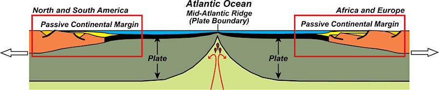
for over the last 150 million years, new limestone formations have been deposited at the bottom of the Atlantic Ocean on the passive continental margin
Source: National Park Service, Mature Ocean Basin Diagram
Links
in the Cambrian Period, the limestones of the Valley and Ridge physiographic province were deposited in a shallow Iapetus Ocean
Source: Dr. Ron Blakey, Paleogeography and Geologic History of North America
References
1. "Limestones," Sedimentary geology course, Massachusetts Institute of Technology, https://ocw.mit.edu/courses/12-110-sedimentary-geology-spring-2007/b66608c6883c8d1512c36e49504f8b7a_ch5.pdf; "The 'Dolomite Problem' - Scientists Resolve 200-Year-Old Geology Mystery," SciTechDaily, January 8, 2024, https://scitechdaily.com/the-dolomite-problem-scientists-resolve-200-year-old-geology-mystery/; Joonsoo Kim, Yuki Kimura, Brian Puchala, Tomoya Yamazaki, Udo Becker, Wenhao Sun, "Dissolution enables dolomite crystal growth near ambient conditions," Science, Vol 382, Issue 6673 (November 23, 2023), https://doi.org/10.1126/science.adi3690; Dr. Dan Doctor, "Determining the Age of a Cave," Virginia Cave Owners Newsletter, April 2012, https://www.dcr.virginia.gov/natural-heritage/document/vacaveownersnewsletter24apr12.pdf (last checked January 15, 2023)
2. "This Is Why Mars Is Red And Dead While Earth Is Blue And Alive," Forbes, May 14, 2019, https://www.forbes.com/sites/startswithabang/2019/05/14/this-is-why-mars-is-red-and-dead-while-earth-is-blue-and-alive/#680c0536395b (last checked January 8, 2023)
3. Adam Gattuso, "Tectonic Significance of the Late Neoproterozoic Swift Run Formation and Basement-Cover Unconformity in the Virginia Blue Ridge," Undergraduate Honors Thesis, College of William and Mary, May 15, 2009, https://scholarworks.wm.edu/handle/internal/12001; Harry W. Webb, Palmer C. Sweet, "Interesting Uses Of Stone In Virginia - Part I,", Virginia Minerals, Virginia Department of Mines, Minerals and Energy, Volume 38 Number 4 (November 1992), p.31, https://www.dmme.virginia.gov/commercedocs/VAMIN_VOL38_NO04.PDF; Z.X. Li et al., "Assembly, configuration, and break-up history of Rodinia: A synthesis," Precambrian Research, Volume 160, Issues 1–2 (January 2008), https://doi.org/10.1016/j.precamres.2007.04.021 (last checked June 13, 2026)
4. Alex Johnson, Chuck Bailey, "The Catoctin Formation - Geology Is For Lavas," Glimpses of the Past: Geology of Virginia, https://wm1693.app.box.com/s/6r6cqm1bpzaowp0pm38qzhjymmx88dft; Scott Southworth, William C. Burton, J. Stephen Schindler, Albert J. Froelich, "Geologic Map of Loudoun County, Virginia" pamphlet to accompany Geologic Investigations Series Map I-2553, US Geological Survey, 2006, p.22, https://pubs.usgs.gov/imap/2553/ (last checked June 13, 2026)
5. Scott Southworth, William C. Burton, J. Stephen Schindler, Albert J. Froelich, "Geologic Map of Loudoun County, Virginia" pamphlet to accompany Geologic Investigations Series Map I-2553, US Geological Survey, 2006, p.22, https://pubs.usgs.gov/imap/2553/ (last checked June 13, 2026)
6. "Roanoke Cement Company LLC," Titan America, https://www.titanamerica.com/our_company/business_activities/roanoke_cement_company/; "Geology Mineral Resources," Virginia Department of Energy, https://energy.virginia.gov/webmaps/GeologyMineralResources/; "The huge climate problem of cement, steel and chemicals, visualized," Canary Media, October 23, 2023, https://www.canarymedia.com/articles/clean-industry/the-huge-climate-problem-of-cement-steel-and-chemicals-visualized; "Geologic Resources Inventory Report," Natural Resource Report NPS/NRSS/GRD/NRR—2016/1237, Colonial National Historical Park, June 2016, pp.21-23, https://npshistory.com/publications/colo/nrr-2016-1237.pdf; "Grafton Ponds Natural Area Preserve," Virginia Department of Conservation and Recreation (DCR), https://www.dcr.virginia.gov/natural-heritage/natural-area-preserves/grafton: Steven M. Roble, Dirk J. Stevenson, "Records of Odonata, Fish, and Birds from the Grafton Ponds Sinkhole Complex, York County, Virginia," Banisteria, Number 12 (1998), https://virginianaturalhistorysociety.com/wp-content/uploads/sites/28/2022/12/Ban_12-Roble-Stevenson_Grafton-Ponds-1.pdf (last checked March 28, 2026)
7. "All About Hokie Stone," Virginia Tech, https://www.vt.edu/about/traditions/hokie-stone.html (last checked June 13, 2026)
8. Bob Self, "Columns Return to 'Rendered' Appearance," Monticello, May 23, 2013, https://www.monticello.org/site/blog-and-community/posts/columns-return-%E2%80%98rendered%E2%80%99-appearance; "Limestone Land," Monticello, https://www.monticello.org/site/research-and-collections/limestone-land#footnote7_yo7ifkp; Wilbur A. Nelson, "Geology and Mineral Resources of Albemarle County," Virginia Division of Geology and Mineral Resources, Bulletin 77, 1962, pp.61-62, p.70, https://www.dmme.virginia.gov/commercedocs/BUL_77.pdf; Avery Ala Drake, Jr., Louis Pavlides, "Stratigraphic Notes, 1993," U.S. Geological Survey Bulletin 2076, 1994, pp.B4-B6, https://pubs.usgs.gov/bul/2076/report.pdf; "Alligator Back Formation - Feldspathic metagraywacke (VACAZmy;0)," Natural Atlas, https://naturalatlas.com/geologic-formations/alligator-back-formation-2769284 (last checked March 28, 2026)
9. "2013 Orange County Comprehensive Plan," Orange County, 2013, p.48, p.50, p.81, http://orangecountyva.gov/DocumentCenter/View/1442/2013-Comprehensive-Plan---BOS-amended-5-8-18?bidId=; "Orange County's Rapidan River reliance," Orange County Review, July 2, 2020, https://dailyprogress.com/community/orangenews/news/orange-countys-rapidan-river-reliance/article_8bfa6134-e353-11e2-b92a-0019bb30f31a.html (last checked December 5, 2020)
10. "Carmeuse is downsizing Strasburg plant in June," Northern Virginia Daily, April 24, 2019, https://www.nvdaily.com/nvdaily/carmeuse-is-downsizing-strasburg-plant-in-june/article_add7feed-0761-53e1-876c-c93a81772f78.html; "Carmeuse to lay off up to a third of Strasburg workforce," Northern Virginia Daily, May 15, 2019, https://www.nvdaily.com/nvdaily/carmeuse-to-lay-off-up-to-a-third-of-strasburg/article_7332ce78-7eda-564c-8fd2-06fb85b1b31e.html (last checked May 22, 2019)
11. "Supervisors' vote buries proposed cat litter plant," Winchester Star, May 24, 2019, https://www.winchesterstar.com/winchester_star/supervisors-vote-buries-proposed-cat-litter-plant/article_41e9e3a6-af0f-52e2-bfbc-c26af1cf2f38.html (last checked May 24, 2019)
12. "Carmeuse Lime and Stone gets approval for new mine in Clear Brook," Winchester Star, November 9, 2023, https://www.winchesterstar.com/winchester_star/carmeuse-lime-and-stone-gets-approval-for-new-mine-in-clear-brook/article_1a154cf9-9bc4-59f4-9a8a-5169eb4c6920.html (last checked November 10, 2023)
13. "1 dead, 1 injured in mine cave-in at Giles County lime plant," WSET, June 20, 2022, https://wset.com/news/local/crews-on-scene-mine-cave-callapes-lhoist-chemical-lime-plant-jon-butler-emergency-services-coordinator-ripplemead-giles-county-virginia; "Lime processing plant in Giles County unable to meet air pollution standards," The Roanoke Times, October 8, 2022, https://roanoke.com/news/local/lime-processing-plant-in-giles-county-unable-to-meet-air-pollution-standards/article_5f7bd868-45b4-11ed-b230-1f8d8901f3d6.html; "Kimballton Underground Research Facility," Virginia Tech, https://www.phys.vt.edu/centers-and-programs/KimbaltonUndergroundResearchFacility.html (last checked October 8, 2022)
14. "Lime processing plant in Giles County unable to meet air pollution standards," The Roanoke Times, October 6, 2022, https://roanoke.com/news/local/lime-processing-plant-in-giles-county-unable-to-meet-air-pollution-standards/article_5f7bd868-45b4-11ed-b230-1f8d8901f3d6.html (last checked August 3, 2023)
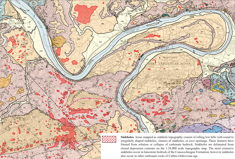
sinkholes are common in the New River Valley near Radford
Source: Virginia Department of Mines, Minerals and Energy, Geologic Map Of The Radford North Quadrangle, Virginia (2009)
Rocks and Ridges - The Geology of Virginia
Virginia Places
