Mining Marl in Southeastern Virginia

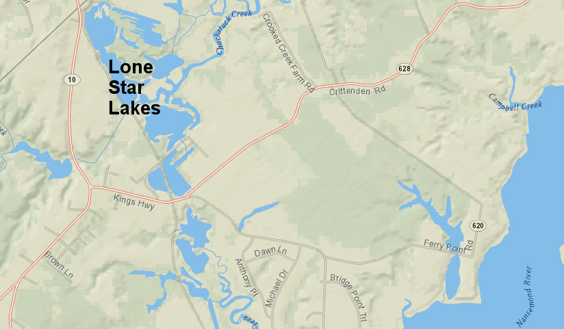
Lone Star Lakes Park in the City of Suffolk marks where marl was excavated for 50 years
Source: ESRI, ArcGIS Online

In Delaware, New Jersey and New York, "marl" refers to Cretaceous Period sediments also known as "greendsands." They are rich in glauconite, a potassium, iron, aluminum silicate derived roiginally from the fecal pellets of marine organisms. Beds of greensands in the Middle Atlantic states may not include a signifcant amount of calcium carbonate (CaCO3).

Farmers near Marlboro, New Jersey, recognized the value of greensand to improve crop yield starting in 1768. The value of adding potassium to the soil was determined by Professor William B. Rogers at the College of William and Mary in 1835.

Greensands in Virginia also are enriched with calcium. It was added by shells on the ocean floor among which the fecal pellets accumulated. Edmund Ruffin studied agricultural chemistry in hopes of restoring the fertility of old tobacco fields, and is credited with the discovery of a greensand deposit in 1818. Ruffin became a well-known agriculturalist and published An Essay on Calcareous Manures in 1832.

Until the 1850's, marl was dug up along the James, Pamunkey, Mattapony, and Rappahannock rivers and spread by enslaved laborers on farm fields. "Marling" was thought to improve crop yields for a decade or more. Before the Civil War, less-expensive and more-concentrated guano from Chile and potash fertilizer from Germany outcompeted Virginia marl.1

An advocate for using marl as a soil amendment and fertilizer wrote:2

Briefly, the decided advantages of using the greensand marl are
First. It is cheaper than all other fertilizers.
Second. It acts favorably on all soils, either clay, sandy or loamy.
Third. It contains nearly all the constituents that are constantly being removed by all crops.
Fourth. It will continue (unlike barn-yard manure) its good effects for many years,variable according to the state of land.
Fifth. In consequence of its affinity for moisture, it keeps the crops in good dark green growing condition in a dry season, when surrounding crops, not marled, die and' dry out.
Sixth. When the land has been limed to death and will yield no crops, the application of say 250 bushels to the acre, will make it fruitful the first year, and its beneficial effects will show more advantageously at every year up to the the third and fourth year, when it will hold its own for a dozen years, with no additional fertilizing.

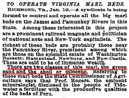
greensands in Virginia include the mineral glauconite (a potassium, iron, aluminum silicate) plus calcium carbonate
Source: TimesMachine New York Times (Jan. 11, 1891)

West of the Blue Ridge, marl deposits were formed in the Quaternary Period from calcium that leached out of Paleozoic Era limestone formations and was deposited near freshwater springs. Travertine and marl have been identified in 57 streams within 17 western counties:3

Deposited as valley fills, some Virginia marls extend to widths of 500 feet across terraced flood plains and have thicknesses up to 60 feet. Buildups of travertine and/or calcareous tufa result from precipitation from stream and spring waters supersaturated with calcium carbonate... Travertine-marl deposits form downstream from sites where groundwater emerges from carbonate rocks. These emergent waters generally mix with surface water prior to calcium carbonate deposition...

The deposits form in summer or early fall during periods of the warmest water temperature and lowest surface flow. Precipitation of calcium carbonate proceeds downstream from the zone of mixing of the warm low calcium surface water and cool higher calcium groundwater... Deposition occurs only after the mixed waters reach supersaturation with respect to calcium carbonate, a result of C02 outgassing.

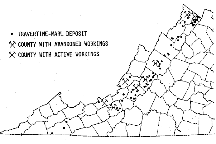
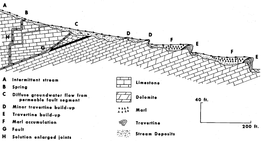
marl deposits west of the Blue Ridge are from freshwater springs, unlike marine deposits on the Coastal Plain
Source: Virginia Minerals, Travertine-Marl Deposits of the Valley and Ridge Province of Virginia - A Preliminary Report (February 1985. Figure 4 and Figure 5)

Calcium-rich marl in Southeastern Virginia comes from a sedimentary bed of shells, or coquina, in the Yorktown Formation that accumulated in the Pliocene Epoch about three million years ago. Within the Yorkown Formation in Virginia, some of the shells once grew on shallow bars on the continental shelf in the Atlantic Ocean. Sea levels were higher 5-10 million years ago during the Late Miocene epoch, and the shoreline was further west at the line of the Suffolk Scarp. A precursor to the James River also carried broken shell fragments down to the bars in the warm waters of the estuary.

During the Pliocene:4

The shoreline retreated from the Fall line area to a position west of Chuckatuck... Along this new shoreline a series of coalescing longshore coquina bars were deposited in water less than 20 feet deep across the bars. The coalescing bars were composed of shells living in situ and fragments of locally derived shells... This late Yorktown longshore-bar complex extended from south of Chuckatuck northward at least to Yorktown.

Sediments deposited in the Pliocene and Pleistocene epochs on top of the Yorktown Formation were later stripped off by erosion, exposing the coquina bars at the surface.

At the northern end of the coquina beds near Yorktown, the Jamestown Portland Cement Corporation mined coquina beds that were as much as 15 feet thick from the bluffs along the York River. The material there was 75-85% calcium carbonate. The Colonial Portland Cement Corporation owned beds as much as 30 feet thick on the James River at the community of Grove, southeast of Williamsburg near the Carters Grove plantation.5

From 1929-1971, marl was mined in Nansemond County, from the Nansemond River ultimately past Chuckatuck to the Isle of Wight County line. Prior to 1924 acquisition of the land by a cement company, sisters Annie and Lucy Upshur mined the marl for use in chicken feed, fertilizer and even driveway construction.6

The raw material was floated by barge to South Norfolk and heated in furnaces there. The American Cement Company built the furnaces on the Elizabeth River, opposite the Norfolk Naval Shipyard, to produce Portland cement. It used marl instead of hard limestone bedrock as the source of the calcium, and was built after shipping marl to the company's existing plant in Pennsylvania to prove the resulting cement would meet the company's standards. The Portland cement, a mixture of silica from local clay and calcium from local marl, was shipped to customers via barge and via the Norfolk & Portsmouth Belt Line.7

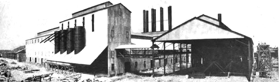
a plant in Norfolk, built in the 1920's, transformed marl mined in Nansemond County (now City of Suffolk) into Portland cement
Source: Cement Age, New Portland Cement Plant at Norfolk, Virginia (p.91)

The potential of using marl from the Nansemond River region to fertilize the soil, and even to make cement, was recognized a century before the American Cement Company completed its plant in South Norfolk.8

The cement companies wanted to built plants closer to their customers in the South as the region began to industrialize after World War I, but there were no outcrops of limestone bedrock in Tidewater where ships could distribute the cement to customers. In Virginia, the closest outcrops were in Loudoun County.

Limestone sediments near Cumberland Gap were economic to develop because coal for heating the furnaces was nearby. The coquina beds near the mouths of the James River and York River were used as raw material primarily because transportation costs were so low. A 1913 report from the US Geological Survey noted:9

They owe their great importance as cement materials not to any superiority in their composition but entirely to their location on tidewater. Indeed, the composition of most of them is hardly attractive to the cement manufacturer, and such of them as do not outcrop on or near deep water and within easy reach of a coal carrying road may as well be dismissed from consideration at once. This fact practically limits development to the beds lying on or near James and York rivers.

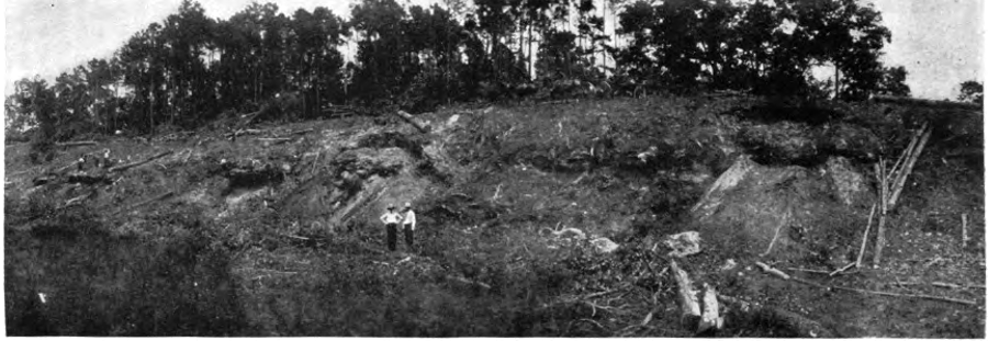
marl was mined from beds on the surface, then excavated from pits that later became recreational lakes
Source: Cement Age, New Portland Cement Plant at Norfolk, Virginia (p.91)

At the mining site, a drag line excavated blue mud from the creekbeds and the narrow (1 mile wide and 5 miles long) vein of marl which had been deposited 35 million years ago. The electrically-powered drag line could excavate marl from as much as 90-120 feet deep. When the rock was so hard the drag line bucket could not scrape it free, dynamite was dropped down to the bottom of the pit. Observers later commented that the resulting geyers were "better than any Disney ride."

The marl was loaded into cars pulled slowly by coal-fired steam locomotives and then by diesels to the hammer mill and washer plant on the Nansemond River. Sand, clay, whale vertebra, and reportedly a fragment of a meteorite were removed before the crushed stone was transferred by conveyor belt to barges and carried to the furnaces in South Norfolk.

The marl pits filled with water and became swimming holes. Local children ignored the No Trespassing signs erected after one boy drowned and used the ponds for skinny dipping. One later reported to the Greater Chuckatuck Historical Foundation:10

Riding your bicycle off the diving board as fast as possible was also a great sport. After the first time we realized that a rope needed to be tied to the bike because it did not float very well even with two inflated tires.

The mining site today is Lone Star Lakes Park, which is in the City of Suffolk after Nansemond County became a city in 1972 and then merged with the City of Suffolk in 1974.

Lone Star Lakes Park includes 12 lakes, some of which are interconnected. Water has filled 490 acres of pits excavated by the Lone Star Cement Company on Cedar Creek. Kings Highway, which leads to the park from Route 10, was the path of the railroad line that carried crushed marl to be loaded on barges on Chuckatuck Creek. Mining stopped in 1971, when the company chose not to upgrade the furnaces in order to meet air quality standards.11

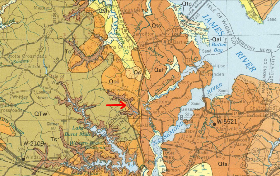
coquina bars from the Yorktown Formation (see red arrow) were deposited in the Miocene epoch, and were mined for over 40 years
Source: US Geological Survey, Geologic map and generalized cross sections of the Coastal Plain and adjacent parts of the Piedmont, Virginia (1989)

Building Stones of Virginia

Limestone in Virginia

Marble in Virginia

Minerals of Virginia

Quarries

Links

References

1. P. S. Boyer, E. A. Guinness, M. A. Lynch-Blosse, R. A. Stolzman, "Greensand fecal pellets from New Jersey," Journal of Sedimentary Research, Volume 47, Number 1 (March 1, 1977), https://doi.org/10.1306/212F714E-2B24-11D7-8648000102C1865D; John Robsin Skeen, "Greensand as a Source of Potassium for Green Plants," American Journal of Botany, Volume 12, Number 10 (December, 1925), https://www.jstor.org/stable/2435305; John McClure, "Edmund Ruffin (1794–1865)," Encyclopedia Virginia, December 7, 2020, https://encyclopediavirginia.org/entries/ruffin-edmund-1794-1865 (last checked January 15, 2024)
2. C. A. Green, Fertilizers in general and the greensand marl of King William County, Virginia, in particular, 1884, pp.5-6, https://lccn.loc.gov/agr12000865 (last checked January 17, 2024)
3. "Travertine-Marl Deposits of the Valley and Ridge Province of Virginia - A Preliminary Report," Virginia Minerals, February 1985, p.3, https://www.energy.virginia.gov/commercedocs/VAMIN_VOL31_NO01.pdf (last checked January 17, 2024)
4. Nicholas K. Coch, "Geology of the Newport News South and Bowers Hill Quadrangles, Virginia," Report of Investigations 28, Virginia Division of Mineral Resources, 1971, https://www.dmme.virginia.gov/commercedocs/RI_28.pdf; H. Dowsett, M. Robinson, K. Foley, T. Herbert, "The Yorktown Formation: Improved Stratigraphy, Chronology, and Paleoclimate Interpretations from the U.S. Mid-Atlantic Coastal Plain," Geosciences, November 24, 2021, https://doi.org/10.3390/geosciences11120486 (last checked January 15, 2024)
5. Samuel Sanford, William Bullock Clark, Benjamin LeRoy Miller, Edward Wilber Berry, Thomas Leonard Watson, "The Underground Water Resources of the Coastal Plain Province of Virginia: 1912-1913," University of Virginia, 1912, pp.254-257, https://books.google.com/books?id=guFIAQAAMAAJ (last checked January 22, 2018)
6. "Lone Star Cement Corporation," Greater Chuckatuck Historical Foundation, http://www.chuckatuckhistory.com/our-story/interests/stores-and-businesses/historical-up-to-1950s/chuckatuck/lone-star-cement-corporation/ (last checked January 17, 2018)
7. Samuel Sanford, William Bullock Clark, Benjamin LeRoy Miller, Edward Wilber Berry, Thomas Leonard Watson, "The Underground Water Resources of the Coastal Plain Province of Virginia: 1912-1913," University of Virginia, 1912, p.253, https://books.google.com/books?id=guFIAQAAMAAJ; "New Portland Cement Plant at Norfolk, Virginia," Cement Age, Volume 12, Number 2 (February 1911), pp.91-93, https://books.google.com/books?id=eJUPAQAAIAAJ (last checked January 22, 2018)
8. "Capacity of the Clays and Rock-Marl of Virginia, to Form Hydraulic Cement, and the Applicability of Rock-Marl to Burning Lime," The Farmer's Register, Volume 9, Number 5 (May 13, 1831), pp.264-267, pp.270-271, https://books.google.com/books?id=Rxg4AQAAMAAJ (last checked January 22, 2018)
9. Edwin Clarence Eckel, "Portland Cement Materials and Industry in the United States," US Geological Survey, Bulletin 522, 1913, p.351, p.356, https://books.google.com/books?id=UO2A3JK_vagC (last checked January 22, 2018)
10. "Lone Star Lakes," Virginia Department of Game and Inland Fisheries, https://www.dgif.virginia.gov/waterbody/lone-star-lakes/; "The hidden jewel," Suffolk News-Herald, May 19, 2015, http://www.suffolknewsherald.com/2015/05/19/the-hidden-jewel/; "Centuries of settlement," Bay Journal, March 30, 2015, https://www.bayjournal.com/article/centuries_of_settlement, "Lone Star Cement Corporation," Greater Chuckatuck Historical Foundation, http://www.chuckatuckhistory.com/our-story/interests/stores-and-businesses/historical-up-to-1950s/chuckatuck/lone-star-cement-corporation/; "Centuries of settlement," Bay Journal, March 30, 2015, https://www.bayjournal.com/article/centuries_of_settlement (last checked January 17, 2018)
11. "Lone Star Lakes," Virginia Department of Game and Inland Fisheries, https://www.dgif.virginia.gov/waterbody/lone-star-lakes/ (last checked January 17, 2018)


Rocks and Ridges - The Geology of Virginia
Virginia Agriculture
Virginia Places