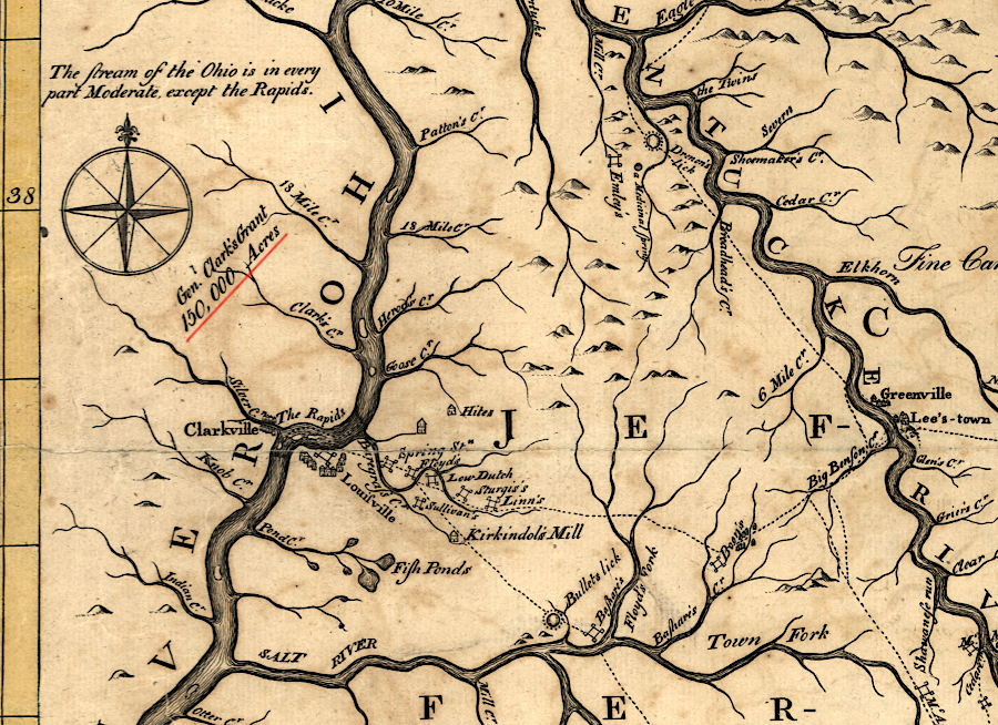
the General Assembly designated 150,000 acres north of the Ohio River for land grants to qualified members of the Illinois Regiment
Source: University of Nebraska-Lincoln, The Discovery, Settlement and Present State of Kentucke (John Filson, 1784)
the General Assembly designated 150,000 acres north of the Ohio River for land grants to qualified members of the Illinois Regiment
Source: University of Nebraska-Lincoln, The Discovery, Settlement and Present State of Kentucke (John Filson, 1784)
At the start of 1778, George Rogers Clark was given a secret assignment to capture the British forts northwest of the Ohio River. As an extra incentive to recruit volunteers willing to make a difficult march from the Ohio River through the wilderness, three key members of the General Assembly wrote to Clark:1
Clark and his 175 men (initially volunteers, then organized as the Illinois Regiment) succeeded in capturing Kaskaskia, Cahokia, and Vincennes. The British reoccupied Vincennes, but Clark recaptured it in 1779 and seized the British commander for the region. Lieutenant Governor Henry Hamilton, known as the "hair buyer" because he was reputed to pay for scalps, and about 25 other British captives were marched back to Williamsburg.
Clark planned to capture the British fort at Detroit, eliminating the base which supplied the Native Americans attacking the western edge of the rebelling states. However, Clark could not gather enough men and supplies. The Illinois Regiment's successful capture of British forts north of the Ohio River led to Great Britain ceding its claims to the Northwest Territory in the 1783 Treaty of Paris. The success of Clark and his men was key to the extension of the boundaries of the United States of America to the Mississippi River at the end of American Revolution.2
The General Assembly honored the secret promise to award land grants to the men in the Illinois Regiment. On January 2, 1781, the legislature authorized the officers to identify a 150,000 acre tract north of the Ohio River, from which parcels would be surveyed for those who qualified. Paperwork asserting a claim to a grant had to be submitted by April 1, 1784.
Clark's Grant ended up being located in the modern state of Indiana, across the Ohio River from Louisville, Kentucky. Clark's Grant is separate from the two military districts that were established by Virginia for soldiers to claim land for their service in the Revolutionary War. Land for the first Virginia Military District was set aside in western Kentucky in 1779, before Kentucky became an independent state. A second military district north of the Ohio River, in what today is the state of Ohio, was reserved in 1784 as part of the arrangement when Virginia ceded its claims to the Northwest Territory to the Continental Congress.3
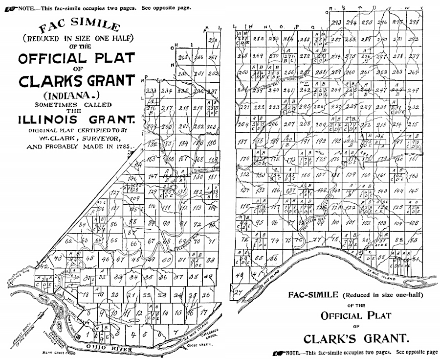
the General Assembly allowed the Illinois Regiment officers to determine the location of 150,000 acres north of the Ohio River for land grants
Source: HathiTrust, Conquest of the country northwest of the river Ohio 1778-1783; and life of Gen. George Rogers Clark (by William Hayden English, 1896)
In 1783, the General Assembly designated 10 officers as commissioners who were responsible for selecting a site for the 150,000 acre grant. They chose a location just downstream from the Falls of the Ohio, which was Clark's preference. The officers had to get the land surveyed in lots that were no larger than 500 acres, and then distribute individual parcels to the Illionois Regiment soldiers. The veterans of that regiment were required to submit paperwork to claim their share by April 1, 1784. They were also required to pay $1.00/100 acres to cover surveying costs.
In the same law, the legislature required that a 1,000-acre parcel be surveyed into 1/2 acre lots for the town of Clarksville. The legislature named the officers as the first ten trustees for the new town, and assigned to the trustees the responsibility for selling the 2,000 lots. There was no requirement for the trustees to live in Clarksville; when one died or resigned, the other trustees replaced him without local elections. Not until sometime after 1889 were the trustees required to live in the town and be elected by town residents.4
The remaining 149,000 acres of the Clark's Grant were distributed only to members of the Illinois Regiment. Revolutionary War soldiers who served in other Virginia units were eligible for lands in the two Virginia Military Districts, but only Illinois Regiment soldiers qualified for land within Clark's Grant.
Officers of the Illinois Regiment determined that grants would be awarded only to those soldiers and officers who had enlisted in the Illinois Regiment prior to January 2, 1781. In order to receive a portion of the Clark's Grant of 150,000 acres, soldiers had to have served prior to the capture ("reduction") of the British posts on the northwest side of the Ohio, or for three years, or to the end of the war. The 10 commissioners decided:5
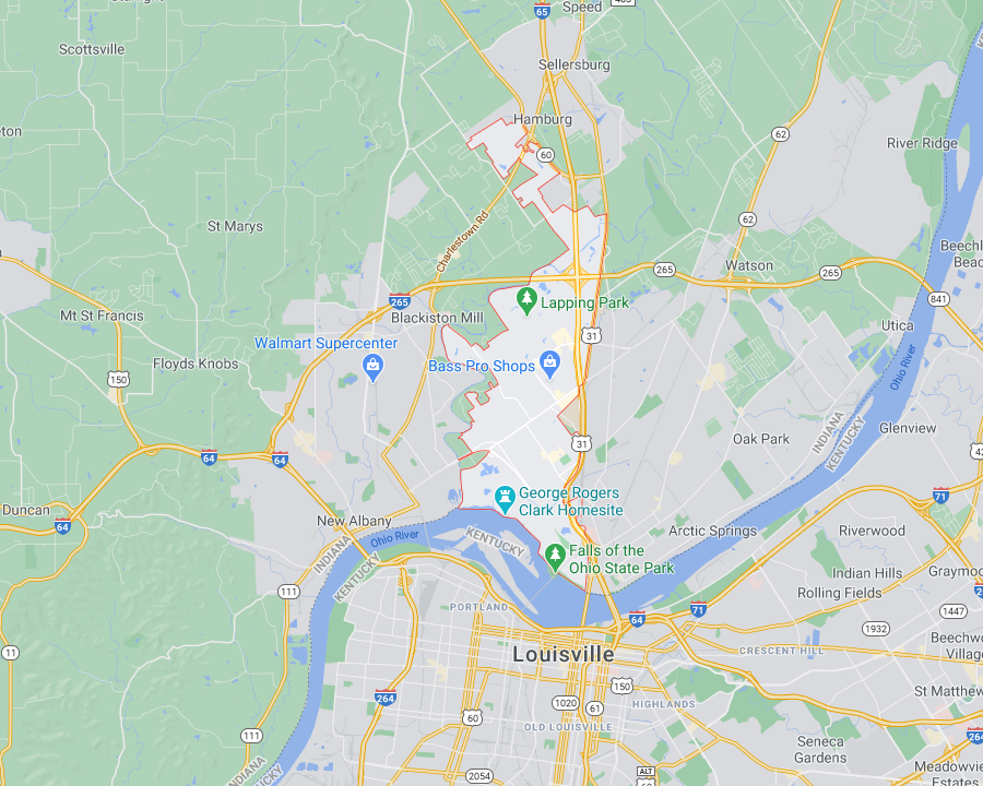
where George Rogers Clark retired to live in Clarksville is now part of the Falls of the Ohio State Park
Source: GoogleMaps
Five surveyors defined the boundaries of the tracts to be conveyed to the soldiers and officers, and whenever they made mistakes the surveys typically provided extra land to the claimant. The commissioners determined how much would be awarded to the 64 officers and 236 privates. George Rogers Clark was given over 8,000 acres, and all officers were granted over 2,000 acres each.
The hierarchical nature of society at the time was reflected in the land allocations - 123,512 acres distributed among the 64 officers, and 25,488 acres distributed among the 236 privates. Privates each got 108 acres, less than the 300 authorized in 1778. The officers who served as the board of commissioners approved the following land grants:6
1 Brigadier-General - 8,049 acres total
1 Lieutenant-Colonel - 4,851 acres total
3 Majors, (4,312 acres each) - 12,936 acres total
14 Captains (3,234 acres each) - 45,276 acres total
20 Lieutenants (2,156 acres each) - 43,120 acres total
23 Sergeants (216 acres each) - 4,968 acres total
1 Ensign - 2,156 acres total
1 Cornet - 2,156 acres total
236 Privates (108 acres each) - 25,488 acres total
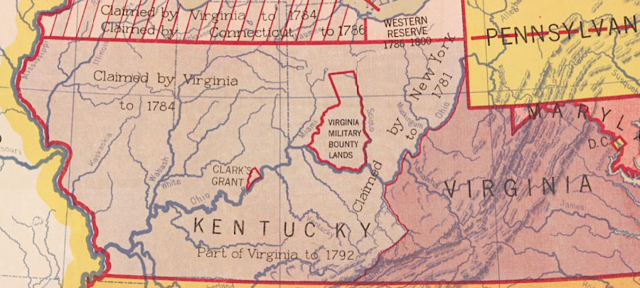
Clark's Grant, 150,000 acres rewarded to members of the members of George Rogers Clark's expedition that captured Vincennes in 1779, ended up in the state of Indiana
Source: Library of Congress, State claims, 1776-1802 (Hart-Bolton American history maps, 1917)