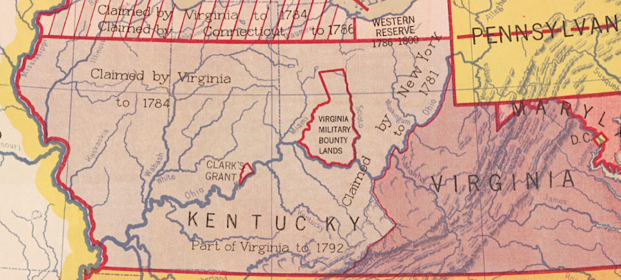
Virginia Military District - Kentucky
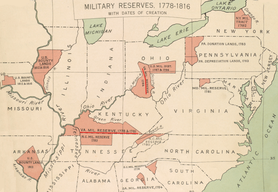
Virginia Revolutionary War veterans could claim land in two military districts, one on each side of the Ohio River in the modern states of Kentucky and Ohio
Source: Atlas of the Historical Geography of the United States, Military Reserves, 1778-1816, With Dates of Creation (Plate 45b, digitized by University of Richmond)
Free land has been an incentive for military service in Virginia since 1646, when 100 acres were provided to encourage a colonist to take command of the palisade at Middle Plantation. Starting in 1679, large chunks of land were granted for free to wealthy individuals who committed to attract settlers, who would increase the colony's ability to resist raids by Native Americans.1
Colonial officials in Virginia planned since 1754 to use western lands to provide bounties promised to those willing to fight. There were two promises of land grants to recruit soldiers for the French and Indian War. Governor Dinwiddie set aside 200,000 acres for the 300 men he wanted to serve under Colonel Fry and George Washington before the Battle of Fort Necessity. Those who enlisted in that initial military force sent to the Forks of the Ohio in 1754 knew they would be paid, but an extra bonus of a land bounty was needed to recruit volunteers.
In 1763, the royal government offered a land bounty for soldiers who enlisted to fight in the French and Indian War after the defeat at Fort Necessity; those soldiers did not qualify for the 200,000 acres set aside by Governor Dinwiddie. The Proclamation of 1763 awarded 50 acres to privates and 5,000 acres to field officers. Soldiers who served only in militia units were not eligible for a bounty; militia duty was a standard requirement for men over 16 years of age during the colonial period.
In 1774, Lord Dunmore committed to set aside 200,000 acres to reward those who fought in what became know as Dunmore's War. He recruited men personally in Pittsburg, while Andrew Lewis led a second column of men recruited on the western edge of the colony. Most came from west of the Blue Ridge, especially from Augusta and Fincastle counties, and some men marched across the Bule Ridge from Culpeper County.
The Proclamation of 1763, with the king's promise of land for veterans, simultaneously included a prohibition against settling west of the Appalachians. That ban prevented colonial governors from authorizing surveys and issuing patents to veterans before the outbreak of the American Revolution.
Governor Dinwiddie had identified in 1754 that 200,000 acres of bounty land would be located near the Forks of the Ohio. However, by the end of the French and Indian War there were many overlapping claims there. A surge of squatters also reached the Ohio River after Pontiac's War ended in 1764, occupying the best acres for farming. Many French and Indian War veterans decided not to wait for their acreage to become available and sold their warrants to land speculators such as George Washington.
The land speculators were willing to finance unauthorized surveys of parcels west of the Proclamation Line of 1763. Thomas Bullitt led a party down the Ohio River in the summer of 1773.
William Preston sent surveyors on the Kanawha River in 1774, despite threats from the Shawnee2
The newly-independent Commonwealth of Virginia re-opened the Land Office in 1779. By that time, a similar offer of "bounty land" was being promised both by Virginia and the Continental Congress in order to recruit soldiers to serve in the Continental Army plus Virginia's state army and navy.
By the time the American Revolution ended, the Virginia Land Office had to deal with bounties promised in order to recruit soldiers to enlist in Virginia's provincial army between 1754-1763, to join Dunmore's special expedition in 1774, and to serve in the State and Continental armies and navies in 1777-1783. A specific 150,000 acre commitment also had been made to encourage men to join the force led by George Rogers Clark to capture British forts in the far northwest in 1778-1779.
In 1777, the General Assembly promised 100 acres to soldiers if they were willing to serve at least three years continuously in the State Army or the Continental Line, or as a sailor in the Virginia Navy. Later, soldiers and sailors who promised to serve until the end of the war were promised an additional 100 acres. The Continental Congress even promised free land to Hessian soldiers who would defect from the British forces. The General Assembly declared that bounties would be provided only after soldiers had completed their time of service.
The rebelling Virginians were not the only ones using land bounties in the Ohio River watershed for recruitment. The British promised land bounties to loyalists and soldiers who enlisted to fight for King George III during the American Revolution. Officials in London expected to award land grants after defeating George Washington's army and re-establishing royal rule in all of North America. After 1783, British promises ended up being fulfilled by using land in other British colonies, particularly Canada.
Before the outbreak of the American Revolution, George Washington established personal relationships with Governor Botetourt and then Governor Dinwiddie and managed to get surveys authorized for allocating Dinwiddie's bounty land to officers and soldiers who had served before the surrender at Fort Necessity. By investing his own funds, Washington got about 20 surveys completed in 1773.
Large tracts were surveyed on the Kanawha River, rather than in the 200,000 acres around Pittsburgh, because there was less risk of a competing claim further west. Washington and fellow investors who helped fund the surveys planned to subdivide those large tracts. Parcels would be allocated first to entitled veterans (or land speculators who had purchased their warrants) who helped fund the surveys.
Governor Dunmore never received directions from London authorizing his to accept surveys and patent land west of the Allegheny Front. He did issue a final patent to his ally Dr. John Connolly on December 16, 1773 for two parcels, 2,000 acres each. That came after the governor visited the site of Fort Pitt and discussed plans to settle western lands with Connolly while there. The county surveyor had rejected the survey, but Dunmore overruled him. (Dunmore ended up a loyalist. In 1780, his 4,000 acres was seized by Virginia.)
A few other grants in Kentucky were also finalized despite the Proclamation of 1763. Beneficiaries included the deputy superintendent of Indian affairs and also the interpreter to
the Six nations at Fort Pitt.
Williamsburg officials did not finalize surveys and award patents to many French and Indian War veterans before the colonial Land Office closed at the start of the American Revolution. The patents for the 200,000 acres promised in 1754 by Lord Dinwiddie to Virginia's first French and Indian War veterans were issued in 1780, after the new Commonwealth of Virginia had opened its Land Office a year earlier.3
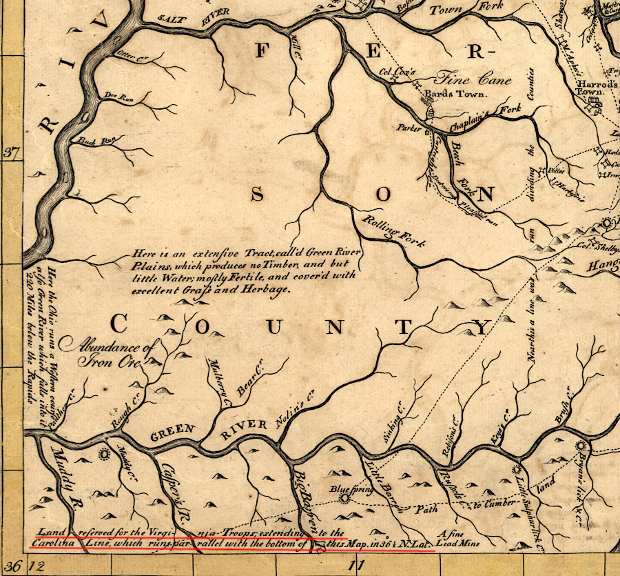
The difficulty in getting Dinwiddie's 200,000 acres surveyed and patented, as promised in 1754, was a clear "lesson learned." To ensure Revolutionary War veterans would not be delayed excessively in obtaining their land bounties by conflicting claims, the General Assembly decided in 1778 to reserve a large portion of western Kentucky. There were few squatters that far west, and no surveys completed by any of the Ohio Company, Loyal Land Company, or other land companies with royal grants to interfere with patents what would be issued by the state.
When Virginia declared independence in 1776, the new state government became the owner of land not already transferred out of colonial control. Treasury rights to purchase state-owned land were sold for for £40/hundred acres to raise revenue. Squatters who had planted corn or already lived on a parcel were able to protect their land against those with a treasury right. In 1779 the General Assembly decided that squatters could validate preemption claims up to 400 acres, and an additional 1000 acres could be purchased at very low rates as well.4
In the Land Law of May 3, 1779, the General Assembly officially reserved lands between the Green River and the North Carolina boundary for military veterans to claim their land bounties, using warrants based on their service.
Since Tennessee had not been established as a separate state in 1779, the southern boundary of the reservation was defined using the "Carolina line":5
- ...a certain tract of country to be bounded by the Green river and a southeast course from the head thereof to the Cumberland mountains, with the said mountains to the Carolina line, with the Carolina line to the Cherokee or Tennessee river, with the said river to the Ohio river, and with the Ohio river to the said Green river, ought to be reserved for supplying the officers and soldiers in the Virginia line with the respective proportions of land which have been or may be assigned to them by the general assembly, saving and reserving the land granted to Richard Henderson and company, and their legal rights to such persons as have heretofore actually located lands and settled thereon within the grounds aforesaid.
North Carolina later defined its own military district in its western lands south of the Virginia-North Carolina boundary. That reservation was established before North Carolina ceded its western lands to the Continental Congress, which created the Southwest Territory The state of Tennessee honored the North Carolina claims when it entered the union in 1796.6
The eastern border of the Virginia Military District established in 1779 was, in practice, at the "Cherokee or Tennessee river" rather than at the Cumberland Mountain (now the eastern border of Tennessee). Settlement on Cherokee-controlled land within the Virginia Military Reserve was not authorized.
The initial western boundary of the Virginia Military District reflected the reality that land there was still controlled by the Chickasaw. In 1781, after the survey of the Virginia-North Carolina boundary revealed how much of the Virginia Military Reserve would be unavailable because it was south of the state boundary, the General Assembly added the section of Kentucky that was west of the Tennessee River and extended to the Mississippi River. That western extension created a reserve totaling 6,000,000 acres for war veteran land bounties.
200,000 acres of land was reserved for Richard Henderson. The General Assembly had rejected all of the patents he awarded in his effort to create a 14th colony called Transylvania, based on his purchase from the Cherokee in the 1775 Treaty of Sycamore Shoals, but the legislators did grant him 200,000 acres. He was given land in the far western edge of Kentucky, in territory later acquired from the Chickasaw. The General Assembly's grant to Henderson was of low value, because the land was located where settlers were not yet seeking to acquire land.
Under the 1779 land law, treasury rights dated after January 1, 1778 could no longer be used to acquire land within the Virginia Military Reserve. Only soldiers with a military warrant, almost all of which were based on Revolutionary War service in the state forces or the Continental Army, could select a parcel in southwestern Kentucky.
Preemption ("tomahawk") claims were valid only north of the Green River, outside the boundaries of the Virginia Military Reserve.7
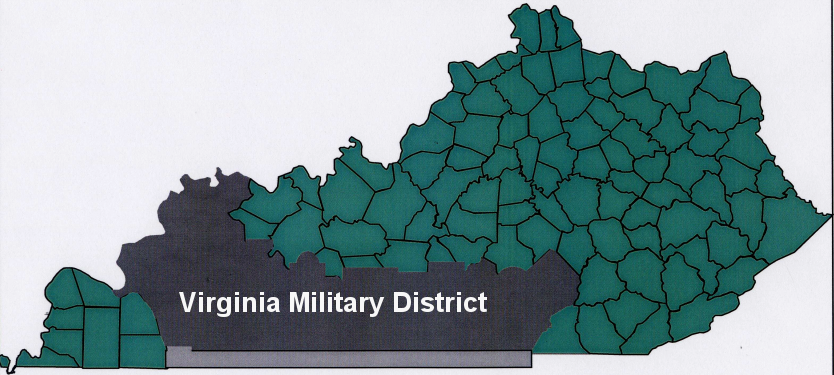
Virginia created a military district in 1779, before Kentucky became an independent state in 1792
Source: Kentucky Secretary of State, Virginia's Military District in Kentucky; Virginia's Western Counties 1780
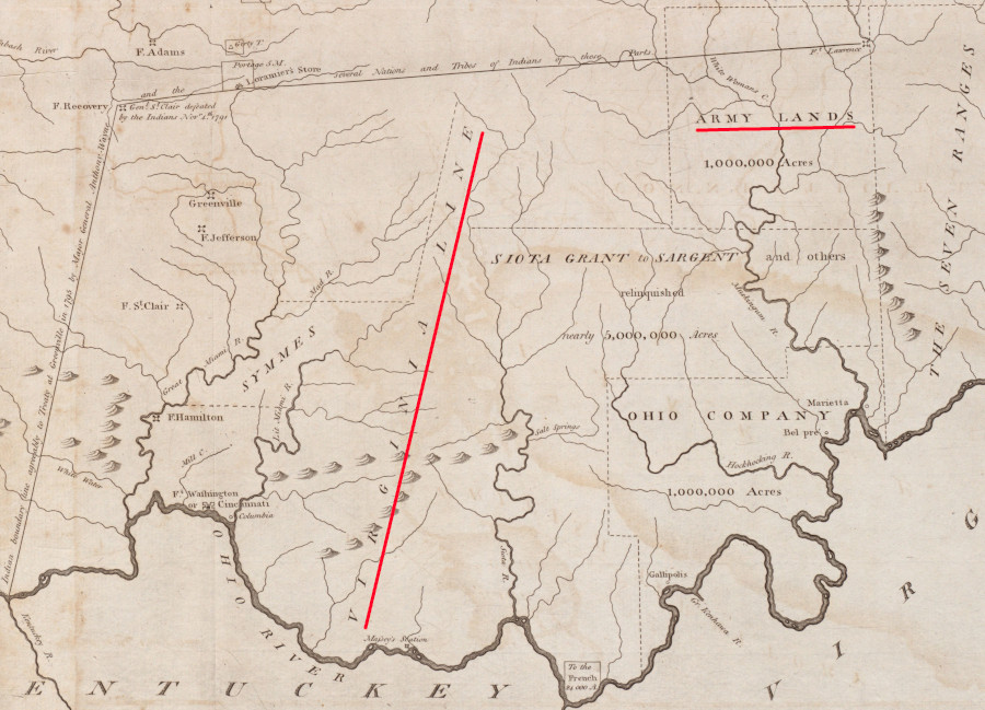
Virginia legislators were still concerned that the state lacked enough land to fulfil its promised land bounties. When the Northwest Territory was ceded to the Federal government on March 1, 1784, Virginia retained the right to authorize grants between the Scioto and Little Miami river. The land reserved north of the Ohio River totaled another 3,700,000 acres. Between the Virginia Military Reserve in Kentucky and the equivalent reserve in Ohio, Virginia banked 9,700,000 acres for its promised land bounties.
Settlers judged the quality of land by the tree cover. Much of the Virginia Military Reserve in Kentucky was grassland. Native Americans had traditionally burned the area to create a grassland which increased the population of buffalo, but settlers viewed treeless "barren" lands as inferior. Only about 2,000,000 acres of the reserve were considered high value. To accommodate demand for better land, the 3,700,000 reserved acres north of the Ohio River were opened to survey and patent on January 25, 1787.
When Kentucky became a separate state in 1792, it ended the ability to use Virginia's military warrants to acquire land. Kentucky opened the lands south of the Green River to settlers willing to buy it. However, the new state agreed to honor the Virginia warrants which had already been accepted. Until 1816, Kentucky approved the surveys required to identify specific parcels based on pre-statehood claims.
By 1792, veterans had submitted entries to claim 1,900,000 acres. Most of the patents were issued to land speculators who had purchased the warrants from the original soldier. George Croghan, who had fought in the American Revolution, was one of many officers who acquired additional warrants. Croghan ended up with the largest land grant of 27,818 acres. An additional 13 people each acquired more than 5,000 acres.8
In May 1782, the General Assembly passed a law saying that anyone claiming land for military service in the American Revolution was required to submit certificates validating their claim to the state war office by January 1, 1783 or, if living outside the state, by June 1. Those who had served for six or more years were given a bonus of 1/6th additional acreage.9
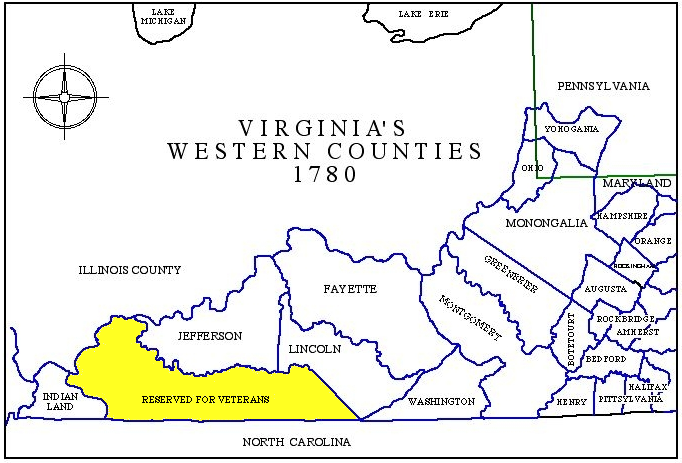
the military district in Kentucky was south of the Green River
Source: University of Nebraska-Lincoln, The Discovery, Settlement and Present State of Kentucke (John Filson, 1784)
Applicants proved to the satisfaction of a local court, using affidavits from their officers regarding how long they had served, that they were entitled to a bounty. Those whose claims were judged to be qualified were given a military certificate by the local justices of the peace.
The certificate was taken to the Virginia Land Office created in 1779. It issued a military warrant which could be presented by the claimant to the official surveyor of the Virginia Military Lands. Military surveyors produced a sketch of a parcel, plus a written description of metes-and-bounds boundaries, that totaled the amount of acreage listed on the warrant.
Claimants then filed the survey documentation with the Virginia Land Office, and that office issued a patent. Those patents (deeds) start the chain of title which documents land transfers over time to modern owners.
The military warrant process was only slightly different from the process for acquiring vacant state-owned land using treasury rights, or headrights obtained by importing indentured servants or enslaved workers. A certificate of military service was not required to use a treasury right or headright. Instead, a certificate was required showing payment for the treasury right or of the number of people imported for the headrights. Surveys were done by county surveyors or their deputies, for which a fee was charged.
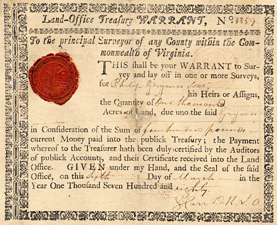
the number of acres of bounty land awarded for Revolutionary War service was determined by the soldier's rank and time of service
Source: Kentucky Secretary of State, Grymes, George (Revolutionary War Warrant 1589.0)
Few veterans were able to complete all the steps required, due to the expense of the paperwork and surveying. Most veterans sold their warrants to land speculators, and not all who qualified for a land bounty even obtained a warrant. The large majority of parcels patented in the Virginia Military District went to people unrelated to the soldier who had served in the American Revolution, Dunmore's War, or the French and Indian War.10
an official land warrant authorized surveyors to identify land in the Virginia Military District for veterans
Source: Kentucky Secretary of State, Virginia and Old Kentucky Patent Series
Claiming land grants while the American Revolution was underway was unrealistic, but soon after the Treaty of Paris the state began to honor its promise. Virginia opened a land office at Soldier's Rest near Louisville on July 20, 1784, to complete the metes-and-bounds surveys required to define the boundaries of specific parcels.
Robert C. Anderson was the principal surveyor appointed by Virginia to run the land office. Within three years he recognized that there was insufficient land remaining in the military reservation in Kentucky. He opened for survey the Virginia Military Reservation in Ohio on August 1, 1787, soon after the Continental Congress passed the Northwest Land Ordinance on July 13.
The US Congress disagreed and voided the initial surveys, after deciding there was still land to be granted in Virginia's "Cumberland Reservation" in Kentucky. Processing to eventually award patents (land deeds) for military service was limited to surveys in Kentucky until 1790, when the US Congress authorized surveying land north of the Ohio River.11
On December 21, 1795, Kentucky's General Assembly passed an act which required the claimant for land in the state's military district to file paperwork before January 1796 to start the process. After that date, land in the Virginia Military District which had not been not identified for a military claim could be patented by others. In 1795 Kentucky also permitted squatters with preemption claims to purchase 200 acres at $0.30/acre, a bargain when the Federal government was selling land in Ohio at $1.00/acre. Through a variety of subsequent laws, the lands south of the Green River ended up being owned by many small farmers. They acquired 200-400 acres from the state at low prices. The farmers raised primarily corn and cattle, and shipped their surplus down the Mississippi River to acquire cash.12
To define the specific boundary of the military district, Kentucky surveyed a line "from the head of Green river to the Cumberland mountain" in 1798.
Some people holding warrants for military land claims, including heirs of veterans and speculators who had purchased the warrants at a discount, filed required paperwork in the Kentucky land office but did not survey specific parcels and obtain final patents. Some claims could not be processed because they conflicted with lands reserved for a settlement with the Transylvania Company. Those who had filed warrants were entitled to land, but finding available parcels was not always feasible. Latecomers discovered that other settlers had already established rights to almost all the land in the district between the Green River and the Tennessee border.
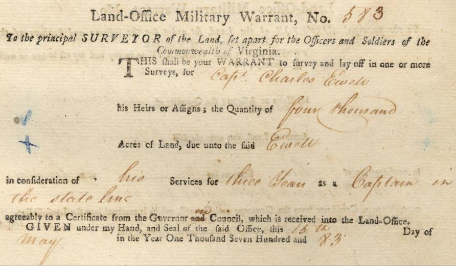
Captain Charles Ewell of Prince William County obtained a warrant in 1783 for a surveyor to define his 4,000-acre parcel of bounty land in Kentucky
Source: Kentucky Secretary of State, Revolutionary War Warrant 0583.0
In 1818, Kentucky purchased claims to land west of the Tennessee River, where some Revolutionary War veterans had already settled. The Jackson Purchase was acquired from the Chickasaw. The Kentucky General Assembly passed a law in 1820 requiring all holding military warrants to complete surveys and file for patents in the Jackson Purchase by the start of 1823. That led to the grant of 242 more patents.13
Heirs and others holding rights to Revolutionary War military land claims obtained the first Bounty Warrants in 1783. A total of 4,748 bounty land warrants were processed. The last grant was awarded in 1876.14
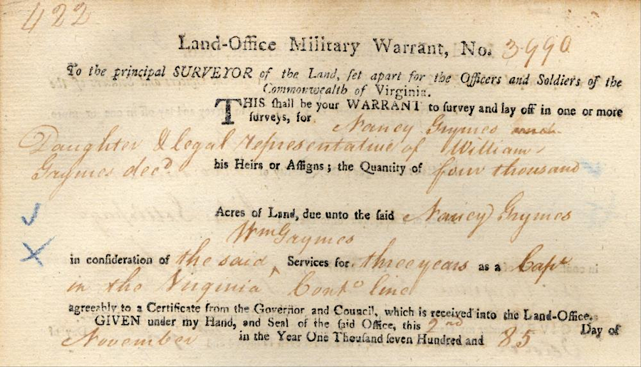
descendants of soldiers and officers, or of land speculators who purchased rights to file claims, obtained bounty lands until 1876
Source: Kentucky Secretary of State, Detailed Information About Grymes, William (deceased) (Land Warrant 3990.0)
Clark's Grant, 150,000 acres rewarded to members of the members of George Rogers Clark's expedition that captured Vincennes in 1779, ended up in the state of Indiana
Source: Library of Congress, State claims, 1776-1802 (Hart-Bolton American history maps, 1917)
Links
two districts with lands for military veterans were established in the Land Ordinance of 1785
Source: Leventhal Map Collection, Boston Public Library, A map of part of the N:W: Territory of the United States: compiled from actual surveys, and the best information (by Samuel Lewis, 1800)
References
1. Benjamin Horace Hibbard, A History of the Public Land Policies, 1924, p.116, https://digital.library.cornell.edu/catalog/chla3069379 (last checked January 12, 2025)
2. Jack M. Sosin, "The British Indian Department and Dunmore's War," The Virginia Magazine of History and Biography, Volume 74, Number 1, Part One (January, 1966), pp.42-43, https://www.jstor.org/stable/4247178 (last checked February 16, 2026)
3. "Researching Revolutionary War Veterans Who Settled In Kentucky," Kentucky Secretary of State, September 13, 2018, https://www.sar.org/wp-content/uploads/2020/02/Researching-Revolutionary-War-Veterans-Who-Settled-in-KY.pdf; "Revolutionary War Military District," Kentucky Secretary of State, http://www.sos.ky.gov/admin/land/military/revwar/Pages/Revolutionary-War-Military-District.aspx; Gabriel Neville, "The New Dominion: Virginia's Bounty Land," Journal of the American Revolution, December 4, 2025, https://allthingsliberty.com/2025/12/the-new-dominion-virginias-bounty-land/; "The Virginia Land Office," Research Notes Number 10, Library of Virginia, February 2010, https://old.lva.virginia.gov/public/guides/Research_Notes_20.pdf; Benjamin Horace Hibbard, A History of the Public Land Policies, 1924, pp.117-118, https://digital.library.cornell.edu/catalog/chla3069379; Wilbur H. Siebert "Kentucky's Struggle with Its Loyalist Proprietors," The Mississippi Valley Historical Review, Volume 7, Number 2 (September, 1920), https://www.jstor.org/stable/1902653 (last checked January 28, 2025)
4. "Revolutionary War Military District," Kentucky Secretary of State, http://www.sos.ky.gov/admin/land/military/revwar/Pages/Revolutionary-War-Military-District.aspx; "Location of Military District - December 19, 1778," Kentucky Secretary of State, https://www.sos.ky.gov/land/resources/legislation/Documents/Location%20of%20Military%20District.pdf (last checked July 10, 2025)
5. "Revolutionary War Military District," Kentucky Secretary of State, http://www.sos.ky.gov/admin/land/military/revwar/Pages/Revolutionary-War-Military-District.aspx; "Location of Military District - December 19, 1778," Kentucky Secretary of State, https://www.sos.ky.gov/land/resources/legislation/Documents/Location%20of%20Military%20District.pdf (last checked July 10, 2025)
6. "Early North Carolina / Tennessee Land Grants at the Tennessee State Library and Archives," Tennessee Secretary of State, https://sos.tn.gov/tsla/guides/early-north-carolina-tennessee-land-grants-at-the-tennessee-state-library-and-archives (last checked June 15, 2025)
7. "Notes and Documents relating to the Transylvania and Other Claims for Lands under Purchases from the Indians [Editorial Note]," Founders Online, National Archives, https://founders.archives.gov/documents/Jefferson/01-02-02-0033-0001; "Settlement Begins: Tennessee and Kentucky-Virginia Takes Over Kentucky," Journal of Applied Research in Economic Development, https://journal.c2er.org/history/vol1-part-x-chapter-x-pre-1800-settlement-of-kentucky-and-tennessee-c-settlement-begins-and-virginia-takes-over-kentucky-watauga-transylvania-company-and-daniel-boone-the-economic-developer/; Gabriel Neville, "The New Dominion: Virginia's Bounty Land," Journal of the American Revolution, December 4, 2025, https://allthingsliberty.com/2025/12/the-new-dominion-virginias-bounty-land/ (last checked January 3, 2025)
8. James A. Ramage, "The Green River Pioneers: Squatters, Soldiers, and Speculators," The Register of the Kentucky Historical Society, Volume 75, Number 3 (July 1977), pp.172-173, pp.176-177, https://www.jstor.org/stable/23378735 (last checked January 5, 2025)
9. William Waller Hening, ed., The Statutes At Large: Being a Collection of All the Laws of Virginia, Volume 11, 1822, pp.82-83, https://catalog.hathitrust.org/Record/009714930 (last checked January 8, 2025)
10. "Clark's Daring Plan," Indiana Historical Bureau, https://secure.in.gov/history/2993.htm; "Revolutionary War Military District," Kentucky Secretary of State, http://www.sos.ky.gov/admin/land/military/revwar/Pages/Revolutionary-War-Military-District.aspx; "About the Revolutionary War Bounty Warrants," Library of Virginia, https://www.lva.virginia.gov/public/guides/opac/bountyabout.htm; "Colonial Wars Bounty Lands (VA-NOTES)," Library of Virginia, https://www.lva.virginia.gov/public/guides/va16_colonial.htm (last checked January 17, 2021)
11. Nelson Wiley Evans, A history of Adams County, Ohio, 1900, pp.39-40, https://archive.org/details/ahistoryadamsco01stivgoog; "Northwest Ordinance (1787)," National Archives, https://www.archives.gov/milestone-documents/northwest-ordinance (last checked July 5, 2025)
12. James A. Ramage, "The Green River Pioneers: Squatters, Soldiers, and Speculators," The Register of the Kentucky Historical Society, Volume 75, Number 3 (July 1977), pp.181-182, p9.186-187, https://www.jstor.org/stable/23378735 (last checked January 5, 2025)
13. "Revolutionary War Military District," Kentucky Secretary of State, http://www.sos.ky.gov/admin/land/military/revwar/Pages/Revolutionary-War-Military-District.aspx; Dr. George W. Knepper, Ohio Lands Book, The Auditor of State (Ohio), 2002, pp.19-23, https://ohioauditor.gov/publications/OhioLandsBook.pdf; "Atlas of Historical County Boundaries," Newberry Library, https://publications.newberry.org/ahcbp/map/map.html#VA; "Anderson, Richard Clough. Papers, Ohio Manuscripts, 1782-1905, 1912-1914," University of Illinois Library, https://archon.library.illinois.edu/ihlc/index.php?p=collections/controlcard&id=425; "Payment to Croghan & Thompson 1798," Kentucky Secretary of State, https://www.sos.ky.gov/land/resources/legislation/Documents/Payment%20to%20Croghan%20Thompson.pdf (last checked July 10, 2025)
14. "Revolutionary War Warrants Database," Kentucky Secretary of State, https://sos.ky.gov/admin/land/military/revwar/Pages/default.aspx; "About the Revolutionary War Bounty Warrants," Library of Virginia, https://www.lva.virginia.gov/public/guides/opac/bountyabout.htm (last checked January 23, 2021)
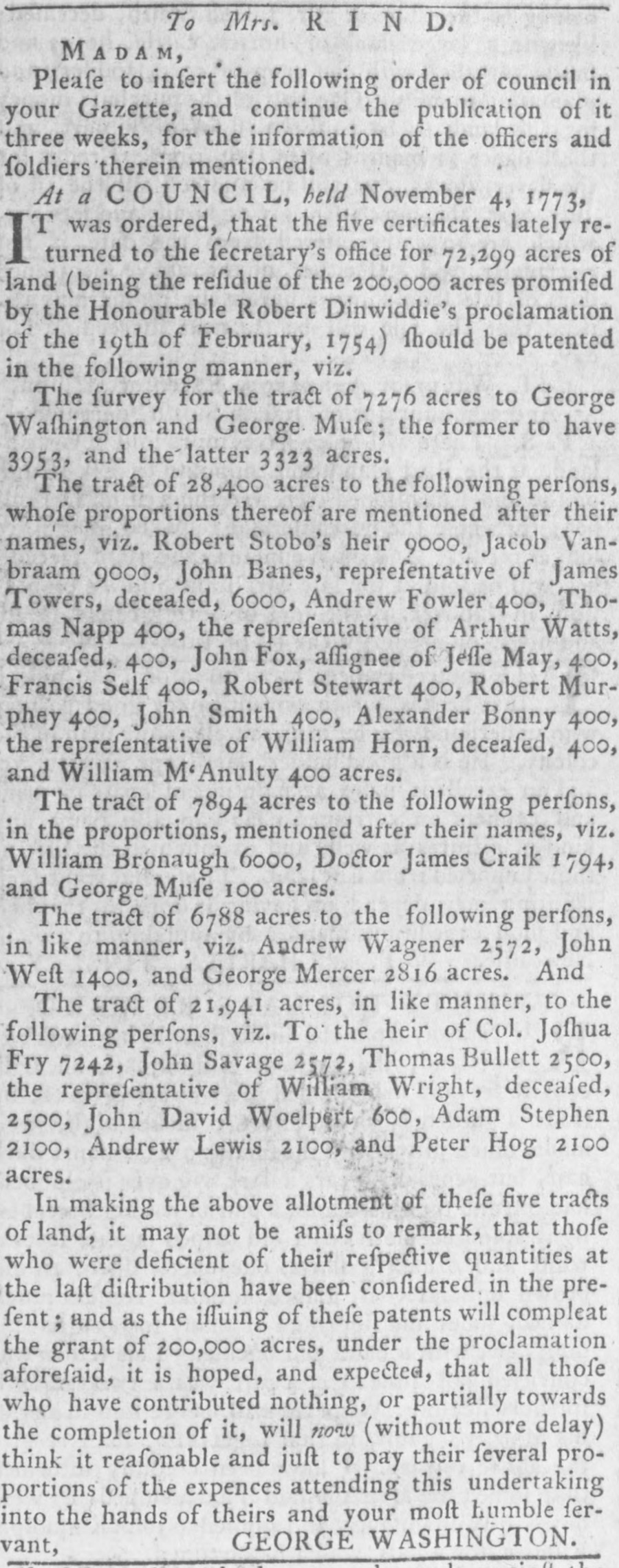
George Washington announced in 1773 the completion of the last surveys for lands granted for French and Indian War veterans
Source: Virginia Chronicle, Virginia Gazette (December 2, 1773, p.3)
The Military in Virginia
Virginia Places