the Coastal Plain is the land between the Fall Line and the shoreline
Source: Virginia Division of Mineral Resources Bulletin 82, Post-Miocene Stratigraphy and Morphology, Southeastern Virginia (Figure 7)
the Coastal Plain is the land between the Fall Line and the shoreline
Source: Virginia Division of Mineral Resources Bulletin 82, Post-Miocene Stratigraphy and Morphology, Southeastern Virginia (Figure 7)
The Coastal Plain extends eastward from the Fall Line to the shoreline of the Atlantic Ocean. Sediments deposited since the Cretaceous Period cover crystalline bedrock. The basement bedrock beneath the Coastal Plain is hard metamorphic rock that was compressed against the edge of Virginia between 450-300 million years ago. In the Taconic and neo-Acadian tectonic orogenies, "terranes" of new crust were pushed against the billion-year old Grenville basement.
In the Alleghenian orogeny 300 million years ago, the tectonic plates with Africa and North America merged to form the supercontinent Pangea. When that supercontinent split up, it left some of the Gondwana (Africa) crust still attached to the edge of Virginia. As the tectonic plates which had created Pangea moved apart and the Atlantic Ocean formed, what is now the eastern edge of Virginia dipped downward.
The original Appalachian Mountains, once about 20,000 or more feet high and located along the route of modern I-95 in Virginia, eroded away. Rivers deposited literally miles of sediment on top of the hard metamorphic bedrock, as the original Appalachian Mountains disappeared over perhaps 50 million years of erosion. Underneath the current Eastern Shore, sediments carried eastward by rivers have piled up over 2,000 feet thick. Since Pangea broke apart, particles that were once at the top of the Appalachians are have been buried between the hard Grenville bedrock and the current land surface.
Going westward from the edge of the Continental Shelf, moving closer to the original Appalachian Mountains, sediment thickness on the Coastal Plain gets thinner and thinner. At the Fall Line, the granitic roots of the original Appalachian Mountains are exposed with no sediment coating the bedrock of the waterfalls in the James River at Richmond, the Rappahannock River at Fredericksburg, or the Potomac River at Washington DC.
Most of the sediments on the surface of the Coastal Plain today are unconsolidated. They were not metamorphosed by lateral pressure because no new terranes have been accreted onto the edge of Virginia in the last 250 million years. The pressure from overlying layers of sediments, deposited by 200 million years of erosion, has not been great enough to compress underlying layers into hard bedrock which were then exposed by erosion on the surface.
Modern construction projects require no blasting; bulldozers and shovels can move the compacted sediments with little difficulty. At the Fall Line, hard metamorphic rock
Native Americans living east of the Fall Line made stone tools from cobbles in the streambeds, since there were no rock outcrops or suitable sites for quarries. The earliest Virginians also traveled and traded to acquire better materials from west of the Fall Line, including hard metamorphic rock from the Blue Ridge and the Uwharrie Mountains now in North Carolina.
In colonial times, English settlers found few outcrops where stone could be quarried. Because early colonists found no stone to use for house foundations, throughout the 1600's even the relatively wealthy leaders lived in structures were made of readily available wood. The manor houses constructed in the 1700's and 1800's on the Coastal Plain, plus the colonial capitols at Jamestown/Williamsburg and the state capitol building at Richmond, used clay. Coastal Plain sediments had to be heated and transformed into brick, as the alternative to building wooden structures.
The gentry displayed their wealth in the 1700's by using enslaved labor to make bricks for mansions such as Westover, and occasionally importing stone. The pavers installed in 1735 on the floor of Christ Church in Middlesex County were brought from southern England, carved out of the Purbeck Limestone Group.1
limestone pavers on the floor of Christ Church were imported from England, since there were no rock outcrops on the Coastal Plain of Virginia
Source: ESRI, ArcGIS Online
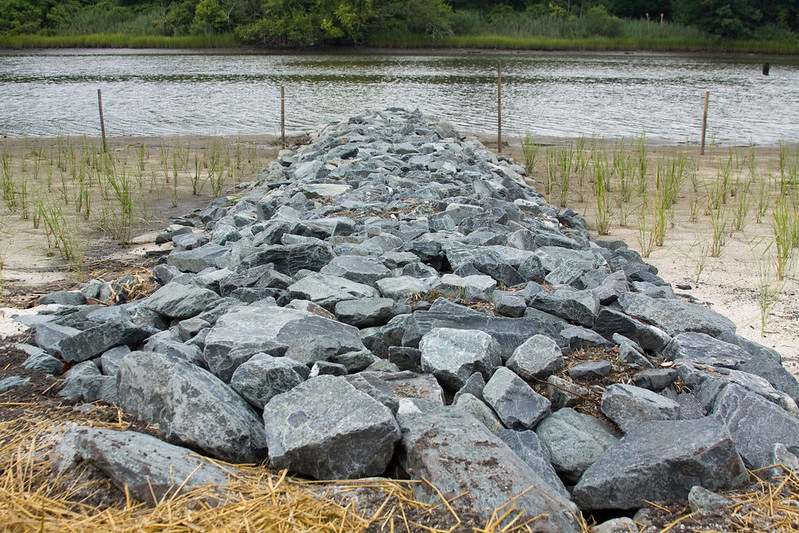
restoring wetlands along Scuffletown Creek, a tributary of the Elizabeth River, required importing metamorphic rock for a barrier on the Coastal Plain
Source: US Army Corps of Engineers, 100804-A-5177B-013
Erosion from the mountains have constantly brought sand, clay, and silt particles downstream. Those that reach sea level settle to the bottom of the Atlantic Ocean.
Changes in sea level resulted in the ocean flooding what today is the Coastal Plain multiple times. Different sedimentary formations were created under different conditions. Formations created when sea levels were high, when the Atlantic Ocean shoreline was at times west of modern I-95, include silica-rich and calcium-rich shells from phytoplankton and zooplankton. Remnants of ocean reefs, shark's teeth, and whale fossils are scattered within the Coastal Plain formations which formed underwater.
When shoreline was west of Richmond, marine sediments were accumulating on what is now part of the Piedmont as well as the current Coastal Plain. Later erosion has stripped sediments off the Piedmont, revealing at the surface the granitic plutons of the original Appalachian Mountains at the Fall Line plus the metamorphic bedrock of the accreted terranes westward to the Blue Ridge.
Erosion is constantly moving sediments and the boundary of the Piedmont eastward, exposing more of the hard igneous and metamorphic bedrock at the Fall Line. Rising sea levels are moving the Atlantic Ocean shoreline westward. As a result, the width of the Coastal Plain between the Piedmont and the Continental Shelf is getting reduced very gradually.
Change is constant over geologic time. Since North America and Africa split apart, sea levels have risen and fallen as tectonic plates and the climate have shifted. When a bolide (comet or meteor) struck what is now eastern Virginia 35 million years ago, there was no Chesapake Bay. That bolide hit the water of Atlantic Ocean, and then drilled deep through accumulated sediments until cracking the hard metamorphic bedrock layer.
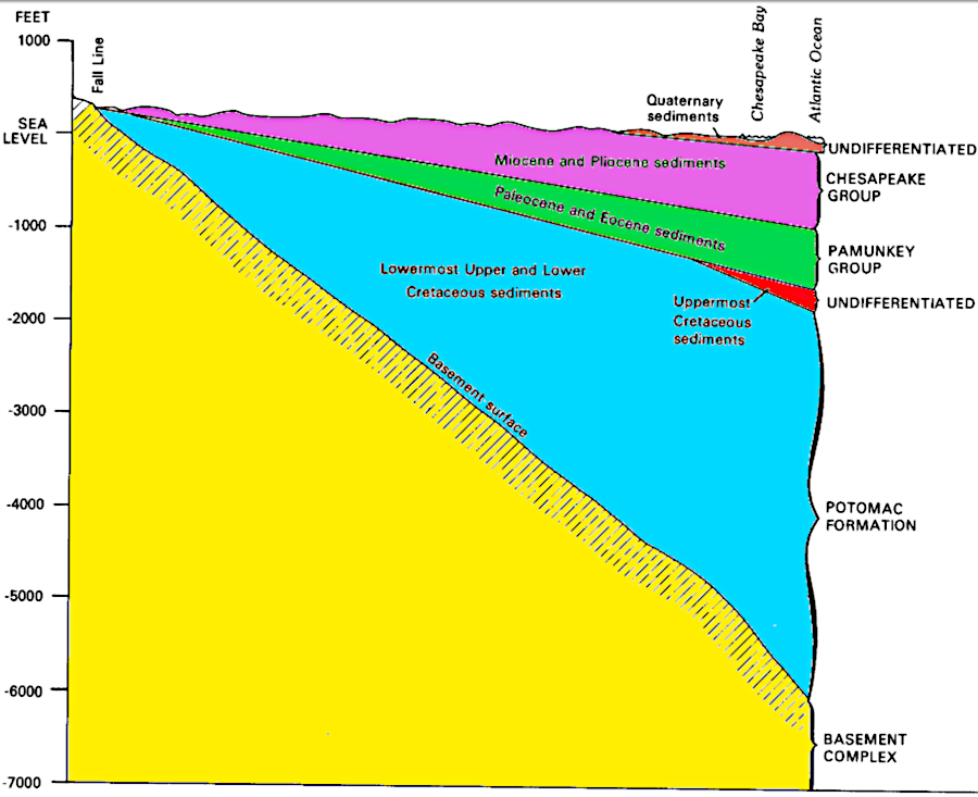
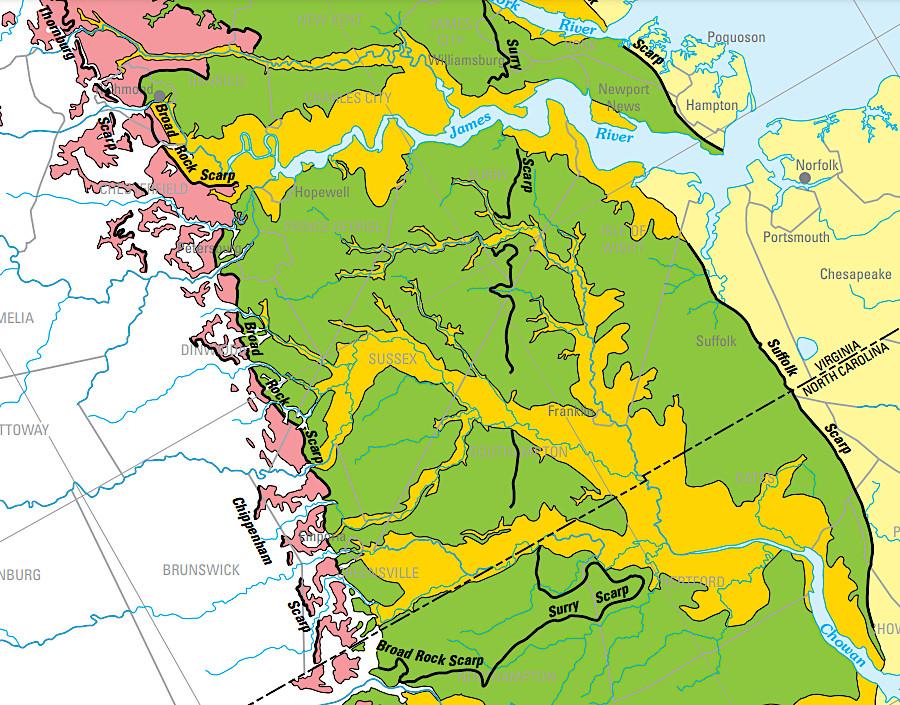
wedges of sediment cover the tilting Coastal Plain bedrock known as the Basement Complex
Source: US Geological Survey, Hydrogeologic Framework of the Virginia Coastal Plain (Figure 5)
Many of the sediments which accumulated during high stands of the Atlantic Ocean later eroded away when the sea level dropped. Sediments deposited when shorelines reached furthest west have washed away, exposing the metamorphic bedrock and soils of the Piedmont physiographic province. The western edge of the Coastal Plain is where sediments still remain, sitting on top of the same sort of metamorphic rocks exposed further west to the edge of the Blue Ridge. The boundary between the Coastal Plain and the Piedmont is marked roughly north of Petersburg by I-95, and by I-85 south of Petersburg to Raleigh.
Geological studies completed before construction of the Surry Nuclear Power Plant revealed that all deposits there during the Miocene Epoch have washed away, along with the last deposits with settled on the ocean floor in the older Miocene and the first deposits of the more-recent Pleistocene epochs. After assessing how the Miocene deposits had been compressed by the overburden, geologists calculated that 150-200 feet of sediments once at that site had eroded away before newer sediments accumulated there during the Pleistocene.2
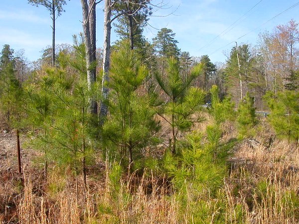
loblolly pine regeneration on sandy soil of Coastal Plain
(Hog Island Wildlife Management Area, north of Surry nuclear power plant)
During the Ice Age, sea levels dropped by roughly 400 feet and Virginia's Coastal Plain extended an additional 40 miles to the east. About 18,000 years ago, sea levels began to rise again, and flood that land. What is now the Outer Continental Shelf is comparable to today's Coastal Plain, with a thin layer of recent sediments on top.
The remaining Coastal Plain, between the Piedmont and the modern shoreline, is a flat surface with a very gentle dip from the Fall Line to the ocean. The flatness is interrupted by two types of topographical features, cliffs and scarps.
scarps on the Coastal Plain reflect times when sea level was higher
Source: US Geological Survey, A Surficial Hydrogeologic Framework for the Mid-Atlantic Coastal Plain (Figure 1)
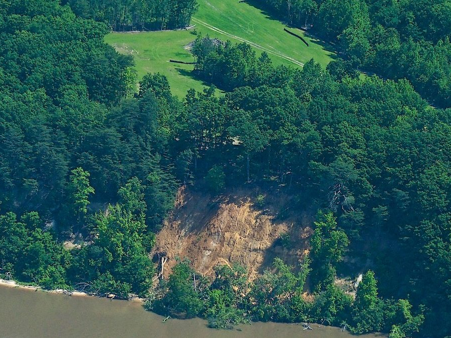
There are steep cliffs on the sides of major rivers. In addition, smaller tributaries have carved their own valleys into the sediments.
At Westmoreland State Park, the Potomac River has etched a channel with cliffs that expose sharks teeth, whale vertebrae, crocodile bones, and other fossils buried in the Miocene-age sedimentary formations. Beaches directly beneath eroding cliffs there and at Stratford Hall Plantation are closed to fossil collecting because of safety concerns. A teenager died in 1975 after a section of the Stratford Cliffs collapsed and the landside crushed him.
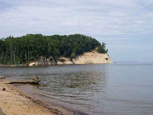
there are cliffs on the Coastal Plain, including Westmoreland State Park
Source: Department of Conservation and Recreation, Westmoreland State Park Master Plan Executive Summary (2017 Update)
On the Rappahannock River, the light-colored diatomaceous earth of Fones Cliffs is exposed for four miles on the river's north bank. In 2015, a developer got authorization from Richmond County to build the "Rappahannock Cliffs" golf course and luxury resort. Near the edge of the 75' tall cliff, 22 houses would have spectacular views to the west. Over 700 other housing units, plus a 116-room lodge, were proposed for the site.
The Chesapeake Bay Foundation and other conservation groups opposed the project, noting the environmental sensitivity of the area. After the developer cleared 13 acres of forested land next to the cliffs for a golf course, but failed to obtain the required permits of install the appropriate stormwater controls, a section of the cliffs collapsed. In response, the state of Virginia sued to block the development from adding excessive sediment to the Rappahannock River. The normal process of erosion had been accelerated by the clearing of the forest above the cliff. The owner, Virginia True Corporation, declared bankruptcy in May, 2019.
Another developer with adjacent property had proposed to build 200 housing units in 10 condominiums. In 2018, he abandoned his plans and agreed to sell the property to a conservation group and ultimately have it transferred to the US Fish and Wildlife Service's Rappahannock River Valley National Wildlife Refuge.
In part because the cliffs attracted bald eagles, members of the local Rappahannock tribe considered the site to be an ancestral ceremonial landscape. They may be the site of the Native American towns "situated high upon white clay cliffs" reported by John Smith in 1608.3
clearing the forest at Fones Cliffs created a surge of erosion and cliff collapse
Source: Friends of the Rappahannock, Fones Cliffs
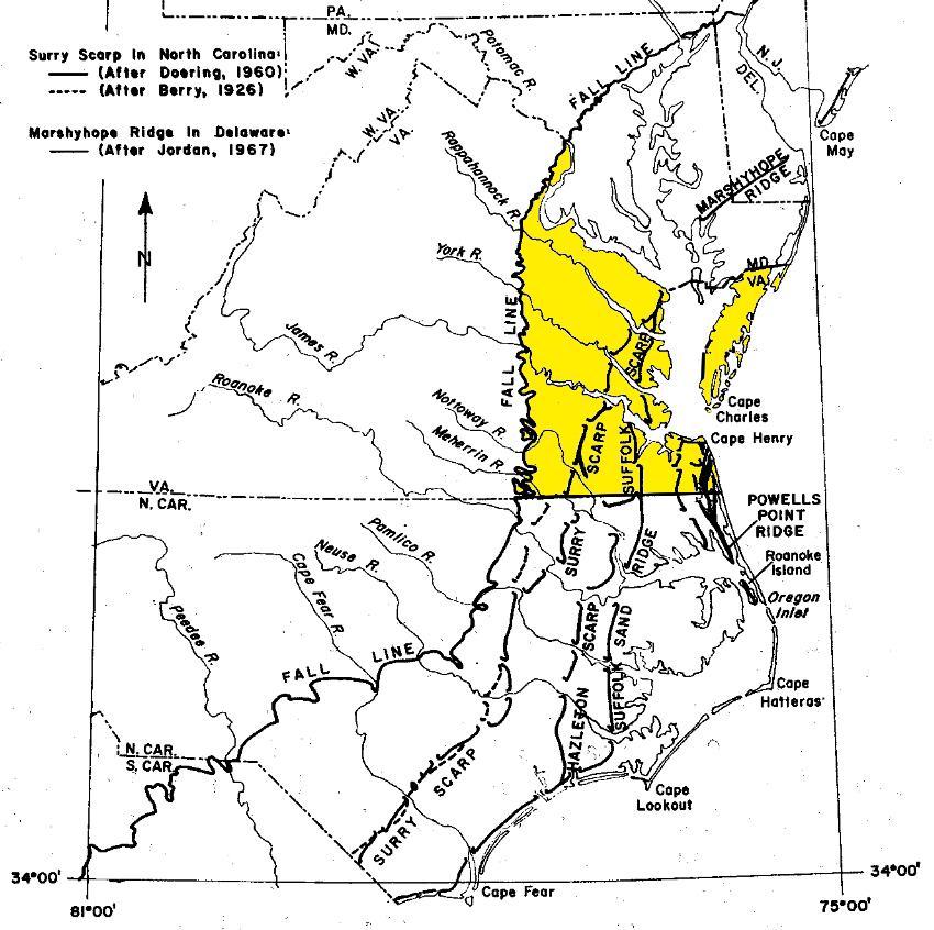
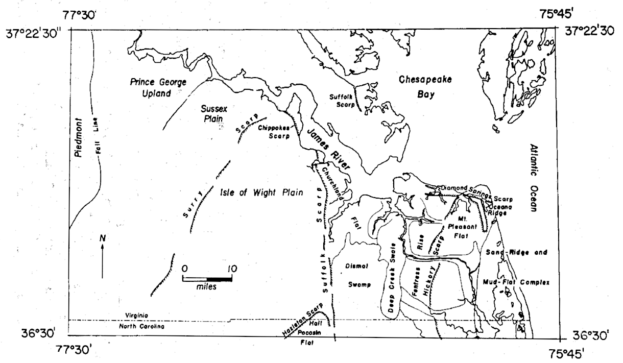
Scarps, where the topography drops 10-50 feet, crisscross the Coastal Plain and are roughly parallel to the Fall Line. Most scarps were created by series of sea level changes.
The Suffolk Scarp drops about 25 feet at the western edge of the Great Dismal Swamp. The Suffolk Scarp formed during an interglacial sea-level high-stand about 125,000 to 80,000 years ago. Everything east of the Suffolk shoreline was flooded when sea level was 20-25 feet higher than today.4
Approximately 50 miles further west, the Surry Scarp rises about 50 feet higher at the western edge of the Isle of Wight Plain. It reflects an older time when sea level was higher.
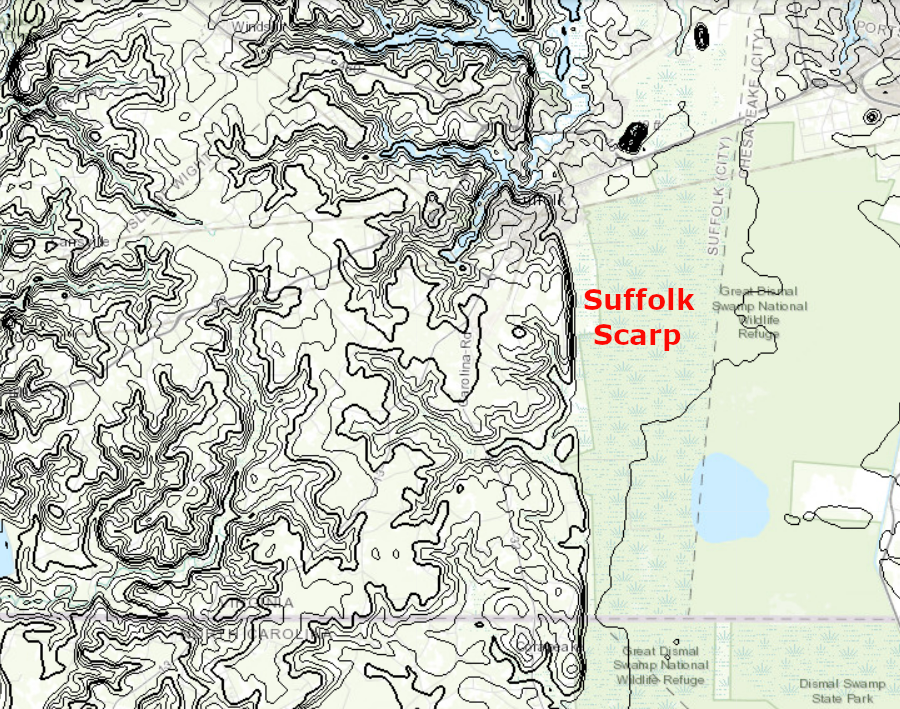
the Suffolk Scarp is just west of Dismal Swamp
Source: US Geological Survey (USGS), The National Map
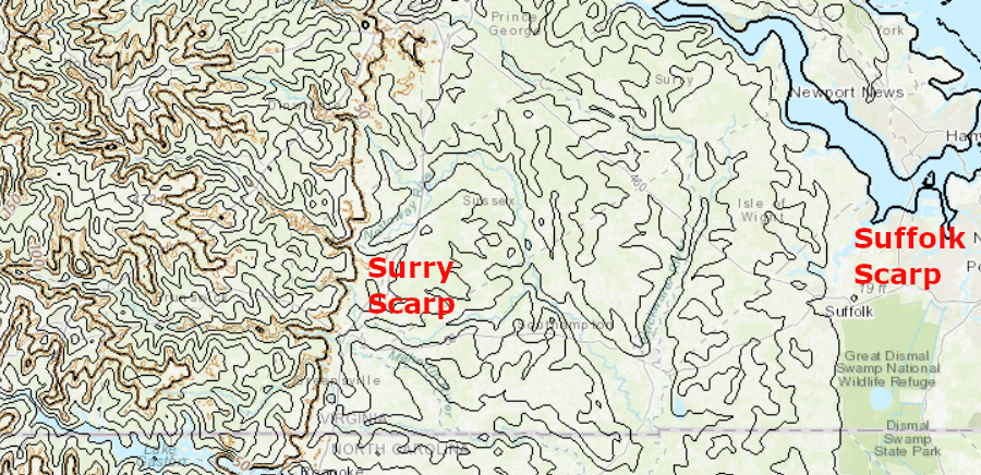
the Surry Scarp is west of the Suffolk Scarp, separated by the Isle of Wight Plain
Source: US Geological Survey (USGS), The National Map
The Atlantic Ocean has flooded over and retreated from the Coastal Plain since the Cretaceous Period, when Pangea split up. During different periods of steady sea level, the waves at the temporary shoreline etched into sediments that had been deposited previously and built barrier islands, dunes, and beaches. When sea level dropped later, a ridge of sand was left inland of the new shoreline.
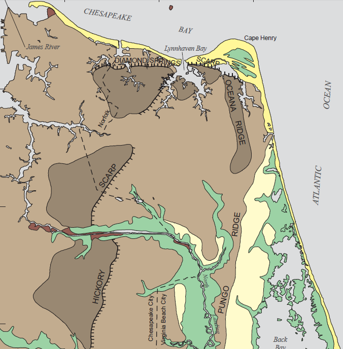
Hickory Scarp formed when sea levels were higher and the Atlantic Ocean shoreline was further west
Source: US Geological Survey, Conceptual Hydrogeologic Framework of the Shallow Aquifer System at Virginia Beach (Figure 12)
A 1973 report from the Virginia Division of Mineral Resources noted that the remaining Coastal Plain:5
Some changes in the sediments at the surface reflect faults in the underlying bedrock. The Stafford Fault slip rate has varied from 0.3 to 1.5 meters/million years over the last 120 million years, with earthquakes triggering faster motion for brief periods. Evidence for the fault includes displacement at the base of the Potomac and Aquia formations. Pleistocene terrace gravels on the surface also have been displaced as a result.
In eastern Prince William/Stafford counties, the fault in the buried crystalline bedrock appears to lie beneath the point where V-shaped valleys at the headwaters of streams broaden into wide flat-bottomed valleys in which creeks and marshes are tidal.
The Stafford Fault, along with the parallel Dumfries, Fall Hill, and Hazel Run faults, may be part of an East Coast fault system stretching 375 miles from South Carolina to Virginia. Due to the fault system:6
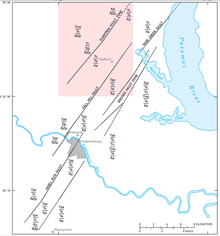
multiple buried faults in the crystalline bedrock affect the location of river channels on the Coastal Plain in Northern Virginia
Source: US Geological Survey (USGS), Geologic Map of the Stafford Quadrangle, Stafford County, Virginia (2005)
The General Assembly passed the Groundwater Management Act in 1973 and updated it in 1992. The Eastern Shore Groundwater Management Area and the Eastern Virginia Groundwater Management Area now provide focal points for research and policy proposals regarding the capacity of Coastal Plain groundwater aquifers and their ability to provide a reliable, long-term supply for municipal, agricultural, and industrial users.
Rivers have continuously eroded the mountains uplifted by the Alleghenian Orogeny. After the supercontinent Pangea broke up, sediments were deposited beneath the Atlantic Oceean. The Potomac Formation, formed during the Cretaceous Period, is the largest aquifer beneath the surface of the Coastal Plain. Later deposits included, at times, more clay particles. The clay-rich layers are mostly impermeable. They have become "aquaclude" that block the flow of groundwater between layers of sand-rich deposits.
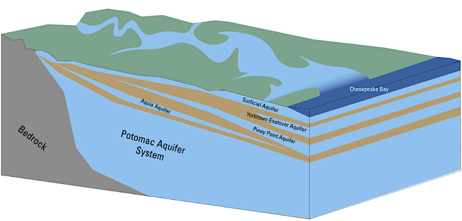
clay-rich layers (brown) are "aquacludes" which separate sand-rich sedimentary layers beneath the surface, forming different aquifers with limited water flow between them
Source: US Geological Survey (USGS), Land Motion and Subsidence on the Virginia Coastal Plain Wells are drilled to different depth to tap into different aquifers.
Major water users, such as the paper mills at West Point and Franklin, extract massive volumes of groundwater from the sand-rich Potomac Formation for industrial use. The Hampton Roads Sanitation District is taking advantage of the permeability of that aquifer for the opposite purpose.
The Sustainable Water Initiative for Tomorrow (SWIFT) initiative is injecting treated wastewater into the aquifer for two major reasons. Injection of wastewater, rather than discharge into the James River, reduces the nitrogen released into the Chesapeake Bay watershed. That reduction is required to meet the Clean Water Act standards and "Save the Bay."
Injection for the Managed Aquifer Recharge (MAR) project in Hampton Roads is also expected to repressurize the aquifer as much as 50 miles away. Repressurization should slow or stop compaction of the sediments which occurred after groundwater withdrawal. Land subsidence from that compaction, together with sea level rise and isostatic sinking of the Coastal Plain after the retreat of the ice sheet that had uplifted it 18,000 years ago, has caused flooding in Norfolk and other areas on the coastline.7
the topography of the Coastal Plain is marked by almost-flat terraces separated by steeper scarps, plus stream channels eroded into the sediments
Source: Virginia Division of Mineral Resources Bulletin 82, Post-Miocene Stratigraphy and Morphology, Southeastern Virginia (Figure 6)
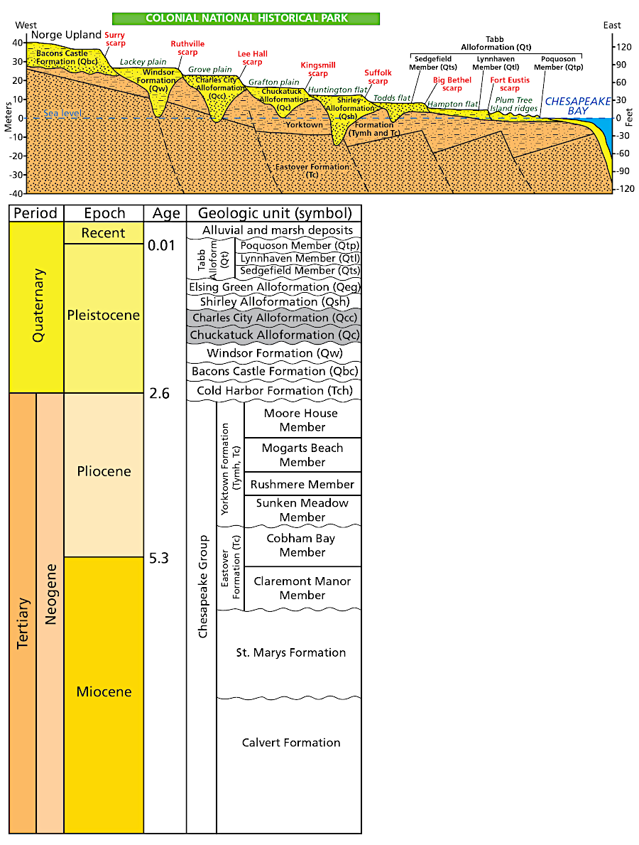
there are multiple stair-step scarps on the Coastal Plain near Williamsburg, created when the Atlantic Ocean was at different sea levels
Source: National Park Service, Cross Section and Stratigraphic Column
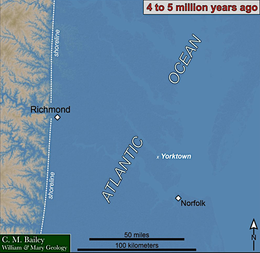

the Yorktown Formation was deposited when sea levels were higher in the Pliocene epoch
Source: Chuck Bailey, College of William and Mary, Geologists Siege Yorktown and Dr. Ron Blakey, Paleogeography and Geologic History of North America
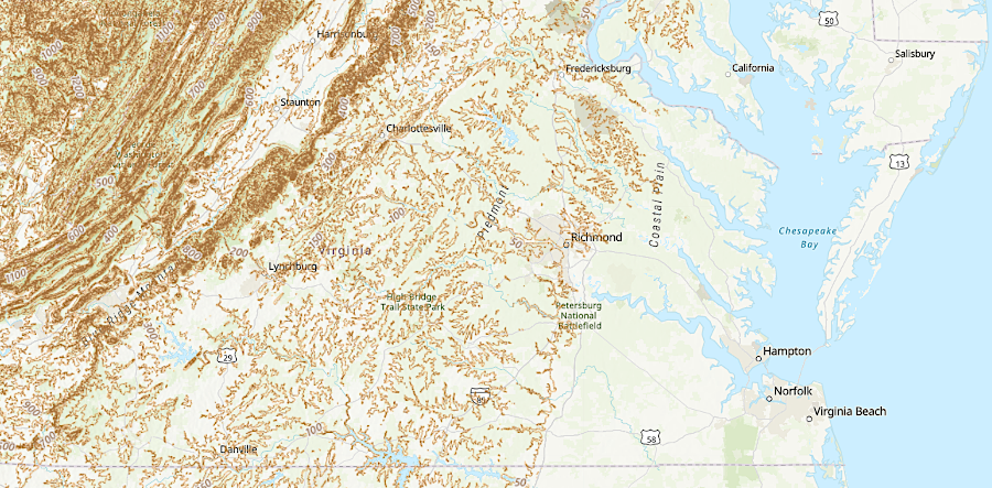
the Coastal Plain has far less topographic relief that the rest of Virginia west of the Fall Line
Source: ESRI, ArcGIS Online
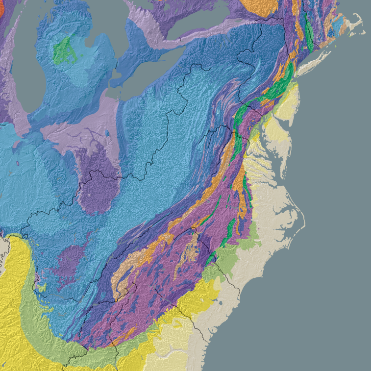
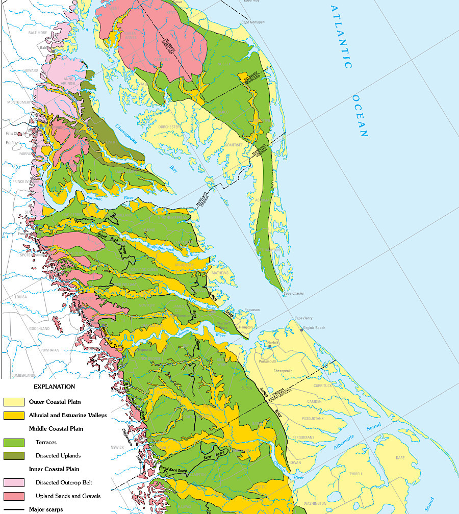
the Coastal Plain (light tan) is located on the eastern edge of the North American continent
Source: US Geological Survey, North America Tapestry of Time and Terrain