Transylvania
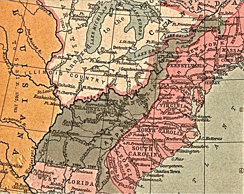
land speculators attempted to establish the Transylvania and Vandalia colonies in the territory acquired in 1763 at the end of the French and Indian War
Source: Library of Congress, The British Colonies in North America, 1763-1775 (from Historical Atlas by William R. Shepherd, 1911)
After the French and Indian War ended in 1763, American colonists anticipated they could settle western lands once claimed by the French. Wealthy investors with political influence who had already obtained land grants, particularly the Ohio Company and the Loyal Land Company, anticipated receiving revenue as parcels were sold. Other investors schemed to obtain new land grants.
Colonists hungry for owning land did not wait for legal arrangements to be completed before moving into the headwaters of the Tennessee River. The Sevier and Robertson families started arriving in 1769.1
Settlers established tomahawk or corn rights that defined an ownership claim by planting crops and building a place to live. Preempting land by being the first to occupy the headwaters of the Holston River was considered legitimate by settlers who lacked another mechanism to acquire ownership.
Military action during the French and Indian War forced the Cherokee out of towns they had occupied for generations. To prevent continuous Native American warfare, early settlers arranged their own deals with the Cherokee. West of the Blue Ridge, the "Overmountain Men" created the rules for occupying land and ensuring community defense based on the patterns they brought from Virginia.
Colonists living on the western edge of European settlement in the 1760's received few benefits from the governments of either North Carolina or Virginia, but desired a government-issued patent that offered legal title to individual parcels of land. However, the location of the edge between the colonies of Virginia and Carolina was unclear. People in the North Holton and Carter's Valley areas did not know the exact location of the 36° 30' line of latitude, which had defined the boundary since 1665.
Most new settlers reached the upper Tennessee River watershed in the 1770's by walking south through Virginia on the west side of the Blue Ridge, rather than heading west from North Carolina and crossing the rugged mountains. They assumed they could obtain land patents someday from Virginia officials. The relevant Virginia county courts for the area were identified as Augusta County until 1770, then Botetourt County until Fincastle County was created in 1772, and Kentucky County until 1780.2
King George III's Proclamation of 1763 blocked settlement in the Mississippi River watershed. The proclamation line was intended to minimize impacts of settlement on Native Americans, thus reducing the costs for the British military to maintain peace between the Appalachians and the Mississippi River.
According to the proclamation, all colonists living in the headwaters of the Tennessee River were supposed to abandon their farms and move east across the mountains. There was no effort to implement such an unrealistic policy by colonial officials, or to block more settlers from moving westward. Instead, the Superintendents of Indian Affairs for the Southern District and the Northern District sought to get Native American approval for shifting the proclamation line further west and legitimizing the expansion of settlement by English, Scotch-Irish, and German-speaking immigrants and any enslaved workers they brought.
The Proclamation of 1763 imposed what colonists expected to be just a temporary constraint on colonial governments authorizing surveys and patenting parcels west of the Appalachians. However, it blocked official surveys and patents.
William Johnson, Superintendent of Indian Affairs for the Northern District, negotiated the 1768 Treaty of Fort Stanwix with the Iroquois. That removed the Iroquois claim to the lands south of the Ohio River. Shawnee, Delaware, Mingo, and others living north of the Ohio River were not allowed by the Iroquois or William Johnson to participate in the Fort Stanwix negotiations. Their objections led to Dunmore's War in 1774, but in the Treaty of Camp Charlotte those tribes relinquished their hunting rights to the lands south of the Ohio River.
John Stuart, Superintendent of Indian Affairs for the Southern District, negotiated with the Cherokee to authorize a revision of the 1763 Proclamation Line. In the 1768 Treaty of Hard Labor and then in the 1770 Treaty of Lochaber, the Cherokee agreed to allow settlement south of the Ohio River and west to the mouth of the Kentucky River. British officials in London approved the treaties negotiated by John Stuart and William Johnson, but still did not issue instructions to royal governors to authorize land patents west of the 1763 Proclamation Line.
John Donelson, surveyor for Pittsylvania County and a member of the Virginia House of Burgesses, surveyed the edge of Cherokee-Virginia territory based on the Treaty of Lochaber and created the Donelson Line in 1772. There was no engagement by North Carolina officials.
Donelson's line was considered to mark the Virginia boundary. Existing settlements at Watauga (now Elizabethton, TN), Nolichucky (now Erwin, TN), and Carter's Valley (between Rogersville and Kingsport, TN) were south of that line. In 1772 those residents formed the Watauga Association, a compact for self-governance which had no official allegiance to North Carolina or Virginia.
The Watauga settlers arranged for a 10-year lease with the Cherokee for use of that land and created a local government based on Virginia laws. The local militia was managed by the leaders of the "association," not by anyone appointed by a governor in Williamsburg or New Bern.3
In 1775, there was no clear colonial authority in the Tennessee River Valley. One entrepreneur, Richard Henderson, took advantage of the void. Henderson was a former judge for the North Carolina colony. On August 27, 1774 he assembled five other investors to create the Louisa Company. Their intent was to buy western land from the Cherokee and create a proprietary colony, and negotiations began in Fall 1774. The British had confirmed in the 1770 Treaty of Lochaber that the Cherokee controlled the land south of the Ohio River and west of the Kentucky River.
On January 6, 1775, Henderson expanded the business partnership and formed the Transylvania Company with a total of eight investors.4
The Transylvania Company purchased 20,000,000 acres from the Cherokee at the Treaty of Sycamore Shoals on March 17, 1775. They paid for the land with £10,000 of trade goods loaded on five wagons.
There were 1,200 Cherokee at Sycamore Shoals, led by Attakullakulla (Little Carpenter), Oconostota, and Sewanooko. A significant number of Cherokee objected to the sale, in part because the payment distributed among so many Cherokee was less than what the men could acquire through a year of hunting. Tsiyu Gansini (Dragging Canoe) led those who rejected the treaty south to create new communities on Chickamauga Creek, and warned that the purchased land would be a "a dark and bloody ground."
The Cherokee on Chickamauga Creek soon allied with the British at the start of the American Revolution and led attacks against the rebelling settlers who occupied the Tennessee River Valley.5
The acreage involved in the Transylvania purchase was extraordinary. No royal grant ever authorized a land company to acquire so much land, though the British government did approve a 20,000,000 acre grant to create the new Vandalia colony in 1774. Creating the Vandalia colony was blocked by the American Revolution, after which a land grant from King George III had no value.
The Transylvania Company was founded upon the premise that it would become the 14th colony. It was to be a proprietary colony like Pennsylvania and South Carolina, and the grant that Lord Fairfax ended up owning. The investors in the Transylvania Company planned to profit by selling land and issuing legal title to their 20,000,000 acres.
Part of the Transylvania Company's purchase from the Cherokee included the "Path Deed." It provided a route from Sycamore Shoals (modern Elizabethton, Tennessee) to Cumberland Gap. Henderson hired Daniel Boone, who had explored Kentucky in 1769-1770, to build a road from Cumberland Gap into the acquired land.
Boone widened the pre-existing Warrior's Path used by the Cherokee to reach the Ohio River at the mouth of the Scioto River in order to raid against the Shawnee. The roadbuilding force reached the Kentucky River on April 1, 1775. There they started building Fort Boonesborough, not far from the existing Harrodsburg station.
Henderson quickly established his own government by organizing a general assembly with 18 delegates in Boonesborough on May 23, 1775. That was the first attempt to establish a colonial government west of the Appalachian Mountains. The delegates passed nine laws, sitting outside on logs probably covered with buffalo and deer hides.
The assembly met underneath a large elm tree with a trunk four feet wide. The tree's wide branches started nine feet above the ground; the leaves formed a green roof. Henderson said:6
- ...one hundred persons may commodiously seat themselves under its shade. This divine tree is to be our church, statehouse, and council chamber.
The May, 1775 gathering at Boonesborough was the only meeting of Henderson's local government. Purchasing land directly from the Cherokee was a very risky business investment for the Transylvania Company. Private land purchases from Native Americans had long been banned by colonial and royal officials. Governors and legislators made clear that only they had authority to negotiate land deals. Nearly all efforts by various colonial traders to acquire land directly were blocked, including side deals negotiated by traders while simultaneously serving as colonial or royal officials.
Many settlers found Henderson's prices to be too high and objected to his demand for two shillings/100 acre in quit rents (equivalent to annual property taxes). New arrivals chose to occupy lands in Kentucky but not to pay the Transylvania Company for surveys or deeds. Instead, the new settlers anticipated that Virginia officials would eventually control the region and grant ownership to those who had preempted land.
North Carolina declared Henderson's purchase to be invalid even before the Sycamore Shoals treaty was signed. The Council of Safety running the North Carolina government, after forcing royal governor Josiah Martin to flee, established the Washington District in late 1776. That district, soon converted into Washington County, annexed the Transylvania lands south of the Virginia border into North Carolina.
The new settlers in Kentucky elected two delegates to serve in the Fifth Virginia Convention, which met May 5–July 6, 1776 in Williamsburg. The District of West Augusta was entitled to elect two delegates, but the Kentucky residents acted on their own. However, when George Rogers Clark and John Gabriel Jones reached Williamsburg they discovered that the convention had already concluded.
The House of Delegates, which met in October, declined to seat the two unauthorized delegates. However, they were able to get the newly-established General Assembly to create Kentucky County on December 31, 1776. That action made clear that the state would not recognize land titles from the Transylvania Company.7
Virginia rejected the legitimacy of the Transylvania Company land purchase and it's attempt to create a local government. The General Assembly formed Kentucky County at the end of 1776, creating an "official" local government for the Transylvania Company's lands north of the North Carolina border. Boonsboro was chartered as a town by the Virginia General Assembly in October 1779, and Kentucky County was split into Jefferson, Fayette, and Lincoln counties on November 1, 1780.8
Henderson viewed the Continental Congress as another opportunity to get approval of the Transylvania purchase. An investor in the Transylvania went to Philadelphia in late 1775, but the representatives of the 13 colonies were seeking to unify as they dealt with the British. Virginia in particular had a leadership role in the Continental Congress, and viewed the control of the Kentucky region as an internal matter not subject to the control of other colonies. The 11 other colonies had no interest in irritating the Virginia or North Carolina delegations by endorsing Henderson's request to become a 14th member of the Continental Congress.9
Even though the American Revolution was underway, Virginia and North Carolina were not occupied by any British troops for several years. The state legislatures had the capacity to have their western boundary surveyed further west from where Joshua Fry and Peter Jefferson had stopped in 1749. The segment surveyed by John Donalson in 1771 was included in the survey which started in September, 1779.
Henderson, who supported the American Revolution and served in leadership positions in the region west of the mountains led the North Carolina component of the commission that oversaw the survey. Like Henderson, Thomas Walker on the Virginia team had a personal interest in determining the location of the boundary. Walker was an investor in the Loyal Land Company. It would be able to patent lands based on its 1749 land grant only in Virginia.
The surveyors and commissioners could not agree on where to draw the line. They ended up creating both a Walker and a Henderson line two miles apart, so confusion continued until a compromise "diamond line" was marked in 1802.10
North Carolina also granted Henderson 200,000 acres. The bold plan to acquire 20,000,000 acres at Sycamore Shoals ended up netting 400,000 acres from two states.
Henderson obtained new investors and John Donelson led settlers on boats down the Tennessee River in 1779. On April 24, 1780 they reached French Lick, a site on the Cumberland River already identified for them to build a settlement. They constructed Fort Nashborough, named after the commander of the North Carolina Continental Troops who was killed at the Battle of Germantown. Mimicking the process used at Boonesborough, the new settlers established a local government. It is now the city of Nashville.11
In 1780, when British officer Patrick Ferguson sent a message to the settlers living in the Tennessee River Valley west of the Blue Ridge that he would lead his army of loyalists:12
- ...over the mountains, hang their leaders, and lay their country waste with fire and sword.
The Overmountain Men then gathered at Sycamore Shoals, coming from as far north as Abingdon. They knew that their claims to land would be voided if the British won the Revolutionary War. About 1,000 men marched over 300 miles, crossing the Blue Ridge. They defeated Ferguson's army at King's Mountain on October 7, 1780 and hung a few loyalist leaders afterwards, firmly establishing that the western settlers were committed to independence from Great Britain.
On November 4, 1778, the General Assembly declared all direct land purchases from Native Americans by various land companies to be void The titles issued by the Transylvania Company were worthless. The legislature did award 200,000 acres to the company as "compensation for their trouble and expense, but it was too far west to have value. Surveys were not completed until 1796.13
Links
References
1. "Watauga Association," North Carolina History Project, Watauga Association (last checked January 3, 2025)
2. "Atlas of Historical County Boundaries," Newberry Library, https://publications.newberry.org/ahcb/va/; "Settlement Begins: Tennessee and Kentucky–Virginia Takes Over Kentucky," Journal of Applied Research in Economic Development, https://journal.c2er.org/history/vol1-part-x-chapter-x-pre-1800-settlement-of-kentucky-and-tennessee-c-settlement-begins-and-virginia-takes-over-kentucky-watauga-transylvania-company-and-daniel-boone-the-economic-developer/ (last checked January 3, 2025)
3. "Watauga Association," Tennessee Encyclopedia, https://tennesseeencyclopedia.net/entries/watauga-association/ (last checked January 3, 2025)
4. "Henderson, Richard," NCpedia, 2024, https://www.ncpedia.org/biography/henderson-richard; "Primary Source: The Transylvania Purchase and The Treaty of Sycamore Shoals, March 17, 1775," Anchor, 2024, https://www.ncpedia.org/anchor/primary-source-transylvania (last checked January 3, 2025)
5. "The Treaty of Sycamore Shoals," Tennessee State Museum, September 29, 2025, https://tnmuseum.org/junior-curators/posts/the-treaty-of-sycamore-shoals; "Watauga Association," North Carolina History Project, https://northcarolinahistory.org/encyclopedia/watauga-association/; "The Myth of Kentucky as a 'Dark and Bloody Ground'," Kentucky Heritage Association, https://heritage.ky.gov/Documents/Myth%20of%20Dark%20and%20Bloody%20Ground.pdf; The Kentucky Encyclopedia, pp.422-423, https://www.google.com/books/edition/The_Kentucky_Encyclopedia/8eFSK4o--M0C?q=&gbpv=1#f=false (last checked January 3, 2025)
6. "Daniel Boone's Trace," Kentucky Historical Society, https://explorekyhistory.ky.gov/items/show/404; "Henderson, Richard," NCpedia, 2024, https://www.ncpedia.org/biography/henderson-richard; "Virginia Rejected Kentucky’s First Attempt at Government," Kentucky Genealogical Society, https://kygs.org/first-kentucky-settlers-government-boonesborough/ (last checked January 3, 2025)
7. "George Rogers Clark battled Indians, elements in 1776," The Advocate-Messenger, December 18, 2023, https://amnews.com/2023/12/18/george-rogers-clark-battled-indians-elements-in-1776/; Donald Gunter, "George Rogers Clark (1752–1818)," Encyclopedia Virginia, Virginia Humanities, December 7, 2020, https://encyclopediavirginia.org/entries/clark-george-rogers-1752-1818/ (last checked February 20, 2026)
8. William Waller Hening, "Statutes at Large, Volume X," 1822, pp.134-135, p.315, https://www.google.com/books/edition/The_Statutes_at_Large/LDIwAAAAYAAJ; "Washington District, North Carolina," Carolana, https://www.carolana.com/NC/Counties/washington_district_nc.html (last checked January 3, 2025)
9. "Virginia Rejected Kentucky’s First Attempt at Government," Kentucky Genealogical Society, https://kygs.org/first-kentucky-settlers-government-boonesborough/ (last checked January 3, 2025)
10. "Records Relating To Tennessee In The North Carolina State Archives," Archives Information Circular, North Carolina
Department of Cultural Resources - Office of Archives and History, Number 3, 1968, http://www.ncdcr.gov/Portals/26/PDF/findingaids/Circulars/AIC3_Tennessee2009.pdf; Franklin K. Van Zandt, "Boundaries of the United States and the Several States," Geological Survey Professional Paper 1212, 1966, p.157, http://pubs.er.usgs.gov/publication/b1212 (last checked January 3, 2025)
11. "Nash, Francis," NCpedia, https://www.ncpedia.org/biography/nash-francis; "Settlement of Middle Tennessee," Journal of Applied Research in Economic Development, https://journal.c2er.org/history/vol1-part-x-chapter-x-pre-1800-settlement-of-kentucky-and-tennessee-d-tennessees-initial-settlement-nashville-and-north-carolina-squats-over-tennessee/ (last checked February 20, 2026)
12. "The Overmountain Men," American Battlefield Trust, https://www.battlefields.org/learn/articles/overmountain-men (last checked January 3, 2026)
13. "Notes and Documents relating to the Transylvania and Other Claims for Lands under Purchases from the Indians [Editorial Note]," Founders Online, National Archives, https://founders.archives.gov/documents/Jefferson/01-02-02-0033-0001; "Settlement Begins: Tennessee and Kentucky–Virginia Takes Over Kentucky," Journal of Applied Research in Economic Development, https://journal.c2er.org/history/vol1-part-x-chapter-x-pre-1800-settlement-of-kentucky-and-tennessee-c-settlement-begins-and-virginia-takes-over-kentucky-watauga-transylvania-company-and-daniel-boone-the-economic-developer/ (last checked January 3, 2025)
Exploring Land, Settling Frontiers
Virginia Places