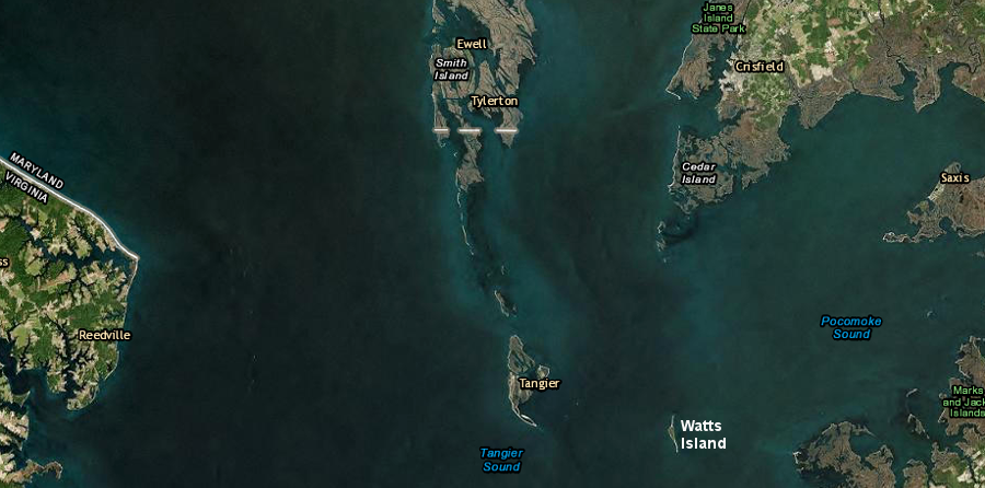
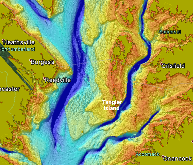
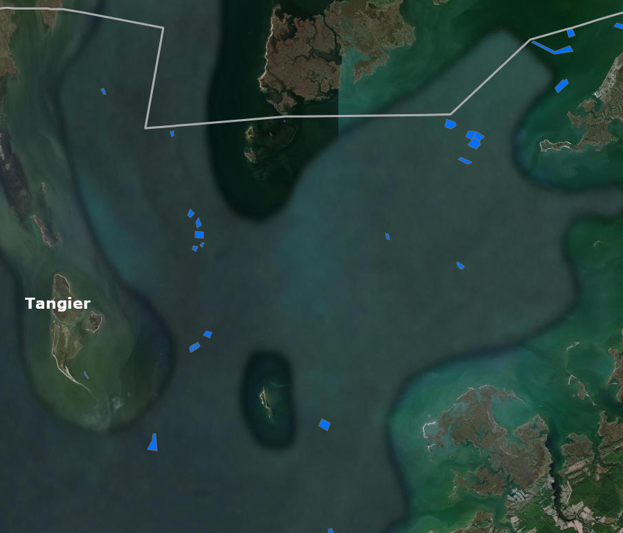
Tangier Island is in the middle of the Chesapeake Bay, with access by ferry from Crisfield, Maryland and (in the summer) Reedville and Onancock
Source: ESRI, ArcGIS Online
Tangier Island is in the middle of the Chesapeake Bay, with access by ferry from Crisfield, Maryland and (in the summer) Reedville and Onancock
Source: ESRI, ArcGIS Online
18,000 years ago, Tangier Island was a ridge on the edge of the ancestral Susquehanna River. When the Chesapeake Bay formed over the last 10,000 years, that ridge was isolated from the Delmarva Peninsula and the mainland of Virginia as saltwater flooded the valleys on either side.
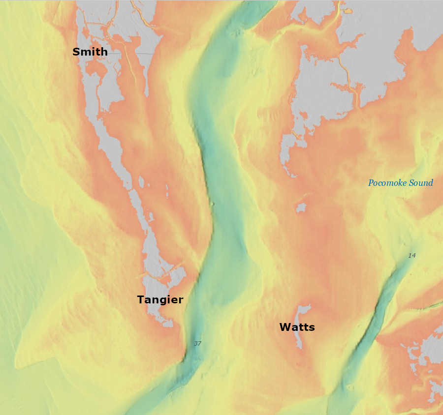
sea level rise over 18,000 years has drowned the valleys and almost all of the ridges close to the channel of the Susquehanna River
Source: National Oceanic and Atmospheric Administration (NOAA), Bathymetric Data Viewer
Today, the highest portions of that ancient ridge remain above water level as separate barrier islands. The existence of each island is seriously threatened by rising sea levels.
the deep channel that separates Tangier Island from the Eastern Shore was a narrow river until the Chesapeake Bay formed in the last 10,000 years
Source: National Oceanic and Atmospheric Administration (NOAA), Chesapeake Bay (M130)
Tangier Sound east of Tangier Island is deep water today, reflecting its origin as a river channel
Source: ESRI, ArcGIS Online
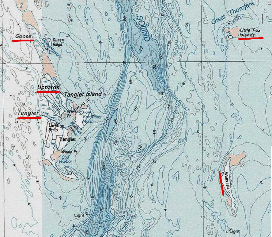
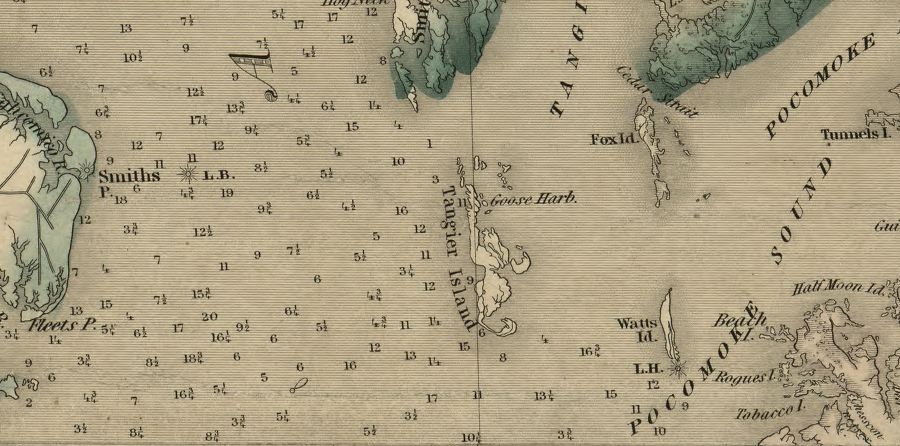
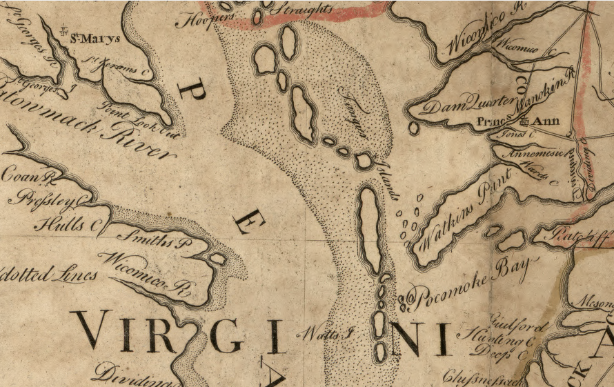
The highest elevation on Tangier is six feet, which is lower than elevations at Accomack County's other populated barrier islands at Saxis and Chincoteague. In the 1780's, colonists could walk along the string of Chesapeake Bay islands from Cedar Straights (now at the Virginia-Maryland border) to the southern tip of the Fox Islands.1
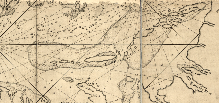
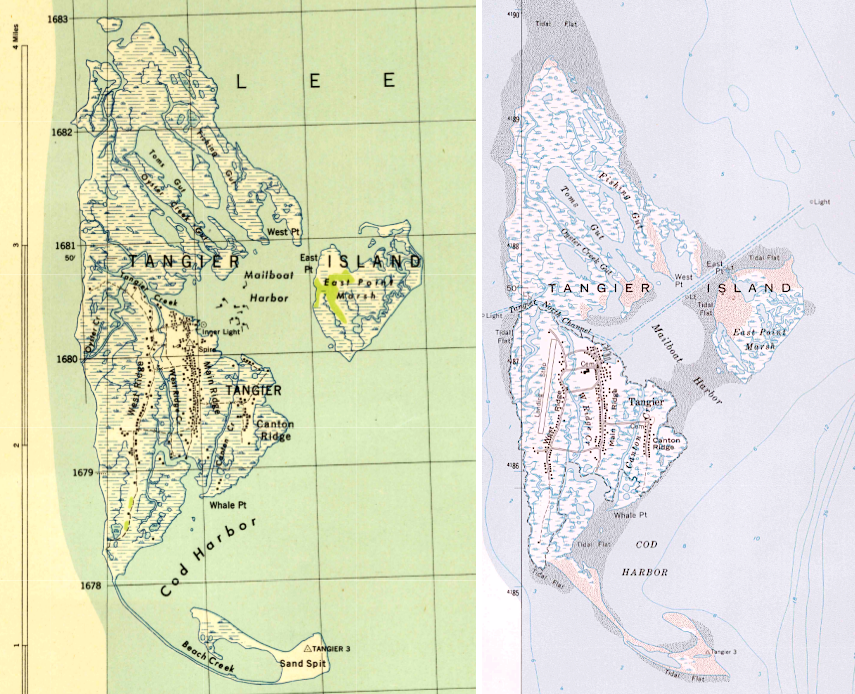
originally, Tangier was mapped as a series of islands, reflecting how ridgetops extended above water level
Source: Library of Congress, A new and accurate chart of the Bay of Chesapeake, with all the shoals, channels, islands, entrances, soundings, and sailing-marks, as far as the navigable part of the rivers Patowmack, Patapsco and north-east (1776)
the 1755 Fry-Jefferson map of Virginia shows more islands in the Chesapeake Bay than are present today, after 400 years of rising sea levels and island erosion
Source: Library of Congress, A map of the most inhabited part of Virginia containing the whole province of Maryland with part of Pensilvania, New Jersey and North Carolina (by Joshua Fry and Peter Jefferson, 1755)
shoals around Tangier Island in the Chesapeake Bay indicate its once-larger extent
Source: Library of Congress, A new and accurate map of Virginia & Maryland : laid down from surveys and regulated astronl. observatns (by Emmanuel Bowen, 1752)
The water table is just below the surface, and groundwater near the surface is saline. Until the 1940's, most houses relied upon rainwater trapped in cisterns for drinking water. In 1983 the private wells, including one dug in 1925 for a fish-packing plant, were consolidated into a community water system.
Fresh water recharge from the spine of the Eastern Shore does not reach the sediments underneath Tangier Island. The community water system relies upon wells drilled 800-1,000 feet deep, extracting groundwater from the deep Potomac Aquifer.
Unlike much of the Eastern Shore, which relies upon the Columbia and Yorktown-Eastover aquifers closer to the surface, the island's water source is the Potomac Aquifer. The aquifers beneath Tangier Island were not disrupted by the bolide impact 35 million years ago. That impact fractured sediments further south, near modern Cape Charles, but not as far north as modern Tangier Island.
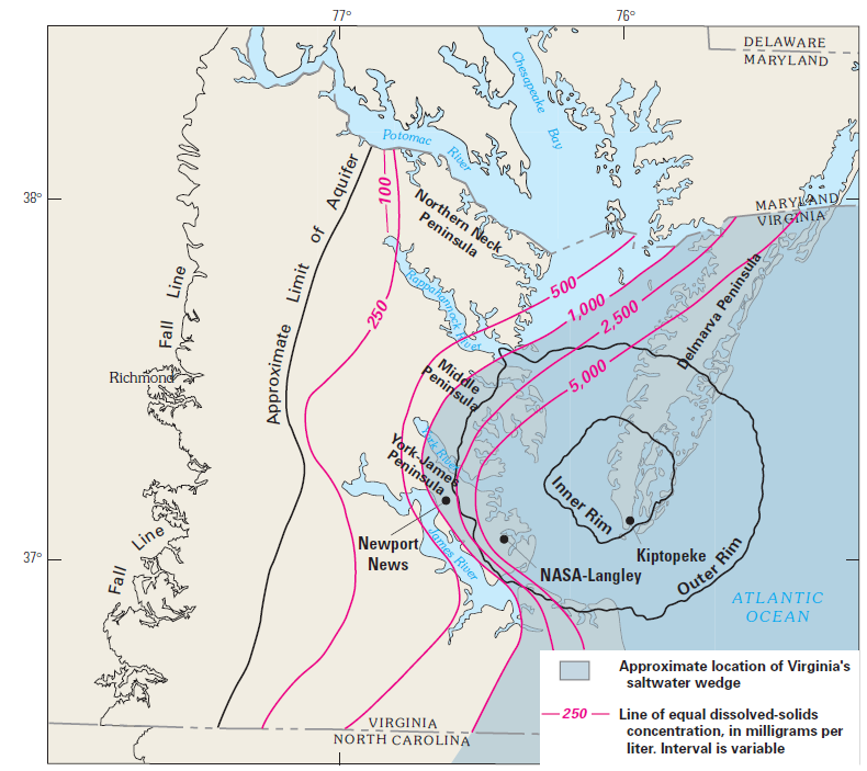
the bolide cracked aquifers south of Tangier, so today they are salty instead of fresh
Source: US Geological Survey (USGS) - Circular 1262, Ground Water in Freshwater-Saltwater Environments of the Atlantic Coast (Figure 15)
The Potomac Aquifer is too deep to be threatened by septic systems or nearby surface contamination, or to be recharged by rainfall on Tangier Island. Recharge of the groundwater originally trapped in the Potomac Aquifer might have to come from locations where that aquifer is at or near ground level. Those areas are located far away near I-95. It will take perhaps hundreds of thousands of years for "new" water to go underneath the Coastal Plain and then under the western side of the Chesapeake Bay, to end up deep below Tangier Island. Groundwater is being "mined" to supply Tangier Island, since it will not be replaced as fast as it is removed.
Distribution from the five 1,000 foot deep wells to customers on the island relies upon surface pipes, with a water tower providing pressure. In January 2019, the system failed. During reconstruction of two highway bridges, the distribution pipes were temporarily attached to the bridges. During a freeze, pipes broke and the 150,000 gallons in the tower drained out. Local residents had to collect seawater for flushing toilets, and fire hydrants were left dry for nearly three weeks.
The mayor of the island town surrounded by the Chesapeake Bay commented:2
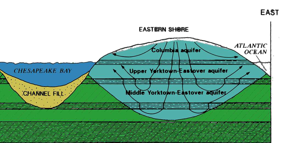
rainfall on the Eastern Shore recharges the groundwater at the top of the Yorktown-Eastover and the Columbia aquifers, but Tangier draws its groundwater from deep wells (800-1,000 feet deep) that tap the Potomac Formation
Source: Eastern Shore of Virginia Groundwater Committee, Our Eastern Shore Groundwater - Part I: Where is the groundwater and how much is there?
Native Americans hunted on the ancient ridgetops for as much as 15,000 years before the formation of the Chesapeake Bay converted the high spots into islands. The islands were uninhabited when the Spanish saw them in the 1500's and John Smith visited in 1608. Smith and his English explorers failed to find fresh water on the islands, so they were not attractive locations for the English immigrants. Colonists did not settle on Tangier Island for another century.
Smith assigned the name Russels Isles to the series of exposed ridgetops known today as Tangier, Goose, Fox, Uppards, and Watts Island (plus Smith's Island, north of the modern Virginia-Maryland border). The name assigned by John Smith in 1608 honored Dr. Walter Russell, the Doctor of Physic traveling in the barge who later treated Smith successfully after he was wounded by a stingray.
the complex of islands are the remaining tips of a peninsula drowned by sea level rise over the last 18,000 years
Source: ESRI, ArcGIS Online
The origin of the name "Tangier Islands" is not known. It was first associated with the complex of islands in 1682. Nine years earlier, "the Western Island" had been used instead of Tangier. A 1713 land grant refers to "Sandy Beach Island." Into the 1800's, references to Tangier could be describing multiple islands rather than the single island known today as Tangier Island.3
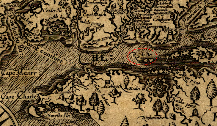
Tangier Island was originally named Russels Isles by John Smith, after the physician traveling on his 1608 journey
Source: Library of Congress, Virginia / discovered and discribed by Captayn John Smith
After the 1644 uprising led by Opechancanough, the English seized him and other warriors in his paramount confederacy. Opechancanough was murdered by an English guard, but other prisoners were carried to Tangier Island and abandoned there without any food.
That was apparently the first time people were expected to do more than just visit briefly, since the land had been isolated by sea level rise. Perhaps the Native American prisoners found trees large enough to make canoes and escape to the Eastern Shore, but it is unlikely that any of the prisoners survived long on Tangier Island. The island was used as a natural concentration camp, one where prisoners defined by their ethnic identity were expected to die through starvation.4
The date of the first colonial settlement on the island is unclear. Local tradition says the Crockett family arrived in the 1680's, though the first recorded deed dates from the purchase of 450 acres by Joseph Crockett in 1778. Crockett remains a very common surname on Tangier, along with Pruitt and Parks.
Tangier was settled permanently by English colonists in the late 1700's, after other Chesapeake Bay islands. Smith's Island to the north was more attractive because it was closer to the deep water channel in the bay. Watts and Fox islands provided adequate drinking water from wells, because they were closer to the peninsula and within the zone in which groundwater near the surface was recharged by local rainfall.
When British soldiers occupying Tangier Island in 1813 made shallow wells by putting open-ended barrels in the ground, the fresh water was quickly exhausted and the wells became brackish. As one author has noted:5
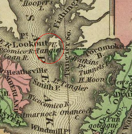
Chesapeake Bay islands have been known by different names - in 1836, what today is known as Smith Island was labeled Upper Tangier
Source: David Rumsey Historical Map Collection, New Map Of Virginia (Henry Tanner, 1836)
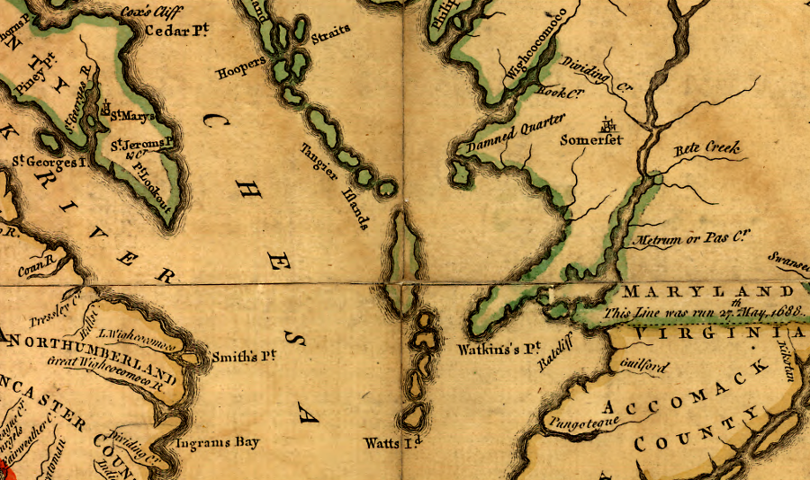
Occupation of the Chesapeake Bay islands did not spur Maryland and Virginia to clarify their colonial boundary. The value of the islands for grazing was minimal, and the submerged oyster beds were not highly valued in the 1600's. Maryland and Virginia surveyed their boundary line on the peninsula of the Eastern Shore in 1688, but did not see a need then to define exactly where the line crossed the Chesapeake Bay and its various islands.
Tangier Island was used for growing cattle and pigs for most of the 1600's and 1700's. Slaves, indentured servants, and hired hands transported livestock to the Eastern Shore by boat. Animals would graze on the marsh grasses unattended and without shelter, until being rounded up and transported back to the Eastern Shore for slaughter.
Tangier offered a guarantee that the cattle/pigs could not wander away without any expenses to build fences. The northern part of West Ridge is known still as Sheep Hill, while the southern part is called Hog Ridge.6
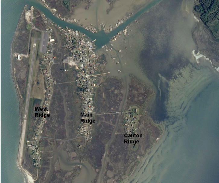
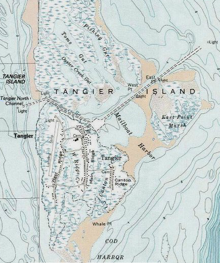
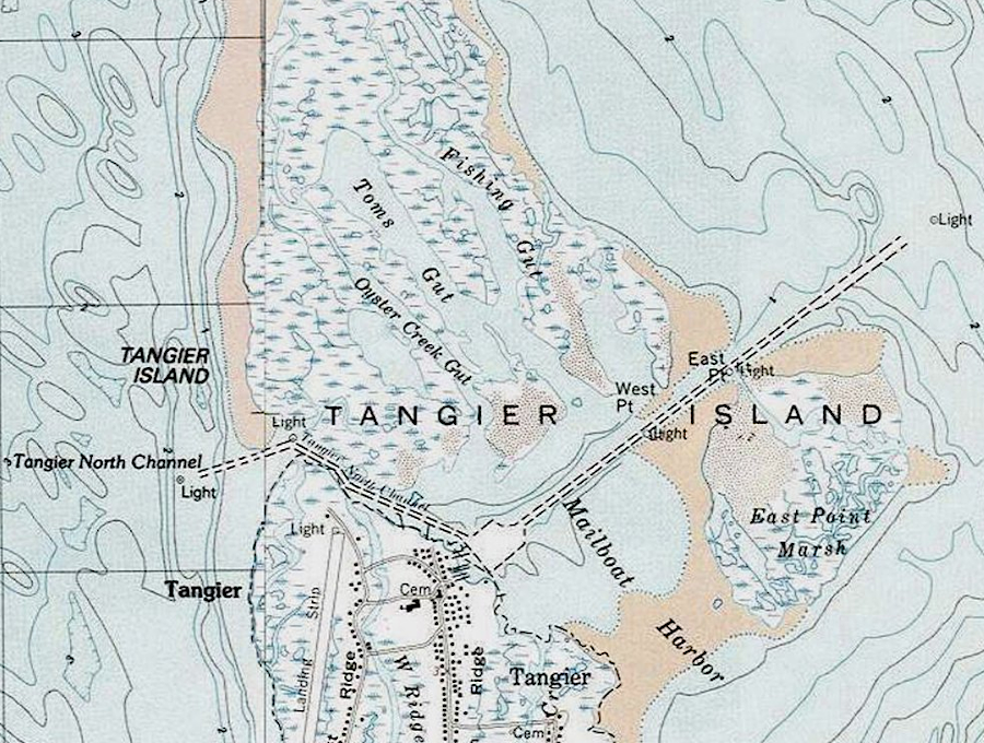
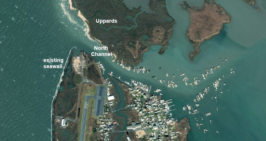
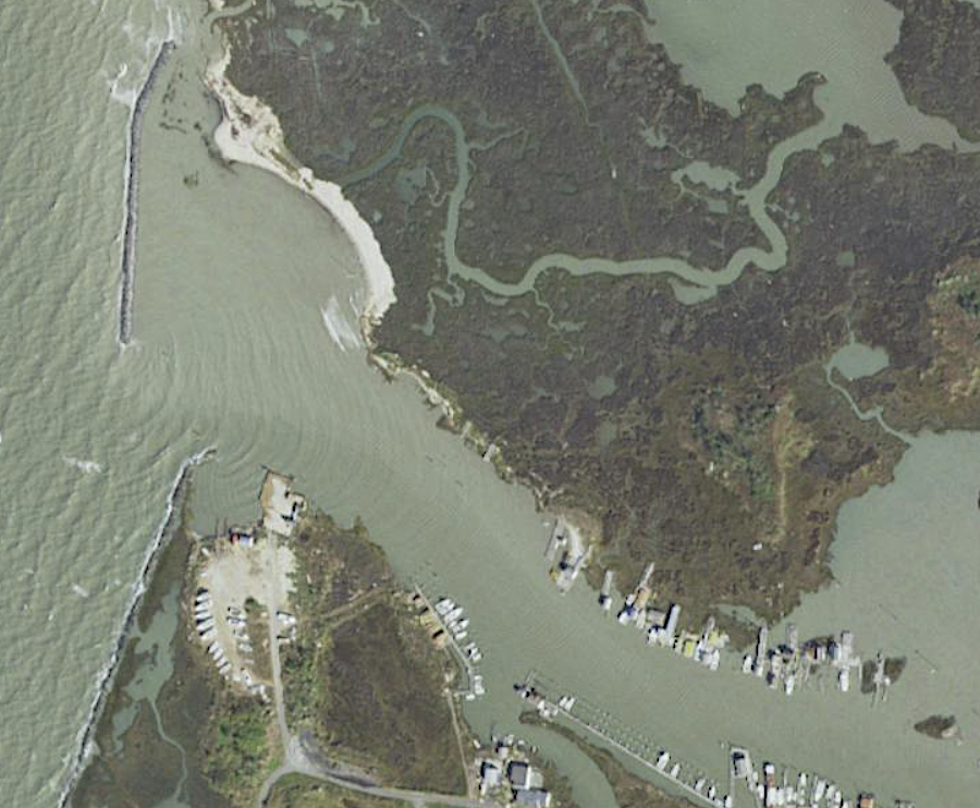
the Uppards area north of the harbor is now unoccupied, and human settlement on Tangier Island is concentrated on three ridges
Source: US Geological Survey (USGS), Tangier Island 7.5x7.5 topographic quadrangle (2013)
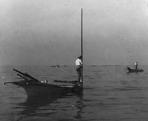
The two most productive ways to make a living on Tangier Island have been to raise livestock and to harvest the natural resources of the Chesapeake Bay by fishing, crabbing, and harvesting oysters. Harvesting blue crabs expanded once that food source became popular in the 1800's. Watermen have also earned cash by piloting other ships sailing in the Chesapeake Bay with captains who were unfamiliar with the shifting locations of shoals and channels.
modern oyster reefs near Tangier Island are in shallow waters to the east
Source: Virginia Marine Resources Commission, Virginia Oyster Stock Assessment and Replenishment Archive (VOSARA)
Islanders did not grow tobacco or other crops in the thin soil. Slavery was not profitable on the ranching operations or for oystering, so keeping an enslaved person on Tangier Island made little economic sense.
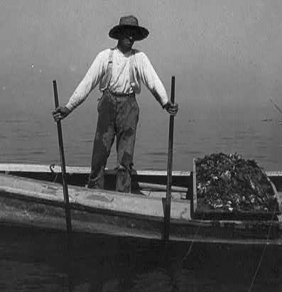
Tangier Island residents have always depended upon seafood to make a living
Source: National Oceanic and Atmospheric Administration (NOAA), Tangier Island crab shack
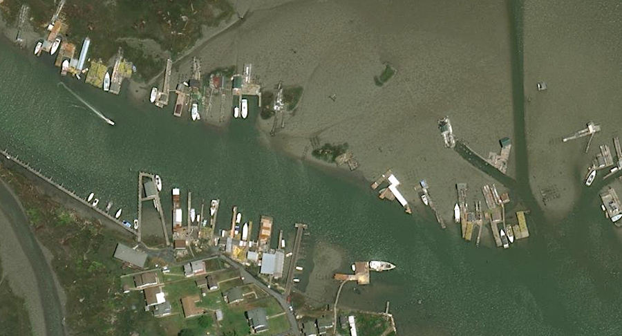
crab shacks line the waterway opposite the Tangier Island dock
Source: ESRI, ArcGIS Online
During the American Revolution, the continuous Loyalist/Patriot guerrilla warfare on land required the islanders to accommodate whoever arrived at Tangier seeking supplies or recruits.
The British roamed freely throughout the Chesapeake Bay, and ships patrolled Tangier Sound between the island and the Eastern Shore. Tangier Island was an easy target for British Navy warships, but the watermen already were inclined to be Loyalists. Tangier's support for the British had an element of "the enemy of my enemy is my friend," because most of the gentry on the mainland that the islanders resented had chosen to become Patriots.
Loyalist islanders with boats ("picaroons") raided like pirates throughout the Chesapeake Bay, seizing supplies to sell to the British forces and plundering for personal benefit. In 1780, a frustrated Governor Thomas Jefferson ordered that all surplus food be removed from Tangier Island. Maryland's governor issued his own order that all residents be forced to evacuate the island.
The Patriots lacked the military capacity to implement those orders, but in 1782 they finally were able to assemble a fleet of armed barges to confront the picaroons. The last naval battle of the American Revolution occurred north of Tangier, and the picaroons won the Battle of the Barges easily. Plans for a second American armada stopped when news reached the Chesapeake Bay that the Treaty of Ghent had been signed in Europe, ending the military phase of the American Revolution.7
Tangier was "no man's land" again in the War of 1812, but this time the British occupied it. During the Chesapeake Campaign in that conflict, the British Navy used the island as a naval base.
The British placed up to 1,000 formerly enslaved Virginians on Tangier. The British trained some to serve in the Corps of Colonial Marines, which was the 1814 equivalent to Lord Dunmore's creation of the Ethiopian Regiment at the start of the American Revolution. The Corps of Colonial Marines built Fort Albion on a portion of the island that has since disappeared.
A British fleet sailed north from Tangier to burn Washington/loot Alexandria and later to attack Baltimore, in the battle where Francis Scott Key wrote the lyrics for the Star Spangled Banner. Raiding the Eastern Shore for supplies continued until news of the peace treaty reached North America in 1815.
After the war ended, the remnants of the British fort which could not be carted away to Bermuda was burned. All the Corps of Colonial Marines and other formerly enslaved Americans were taken away as well by the British Navy, because Rear Admiral Cockburn refused to comply with Article 1 of the Treaty of Ghent. That article required the British to deliver all seized "property" to the Americans. In 1826, the British finally paid $1.2 million in compensation for failing to return the enslaved people.
A hurricane in 1821 washed away much of the evidence of Fort Albion, and archaeologists assume the site is now underwater.8
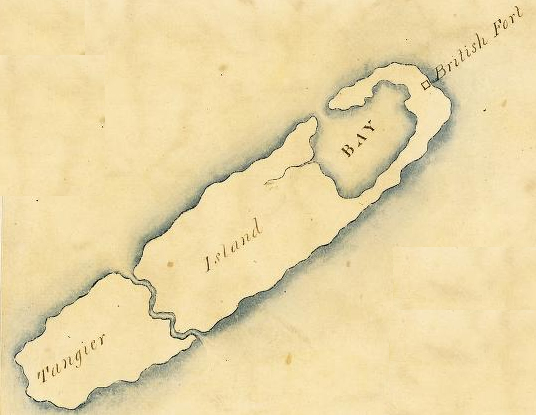
the site of Fort Albion was recorded by John Wood when he mapped Accomack County in 1820
Source: Library of Virginia, Accomack County (John Wood, 1820)
By the mid-1800's, much of the island's trade involved shipping seafood to cities in the northern states. Because of the absence of slavery and the economic links to the North, during the Civil War the island was sympathetic to the Union rather than to the Confederacy.
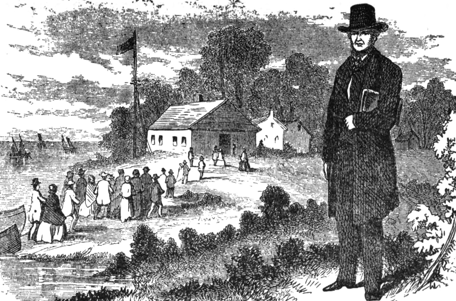
One thing has remained consistent on Tangier Island: the significant role of the Methodist Church in community life. That denomination became dominant on the Eastern Shore after the American Revolution, when the Anglican Church was associated too closely with the British government. Joshua Thomas, the "Parson of the Islands," is credited with holding fiery camp meetings on the island after he converted in 1808.
the Methodist faith has been dominant on Tangier Island for over 200 years
Source: The Parson of the Islands (p.45)
In 1814, at the request of British Admiral George Cockburn, Joshua Thomas preached to the British forces before they attacked Baltimore. In his confrontational "Thou Shalt Not Kill" sermon, Thomas predicted correctly that the attack would fail. Within a week, Francis Scott Key memorialized that British failure at Baltimore in the Star Spangled Banner.
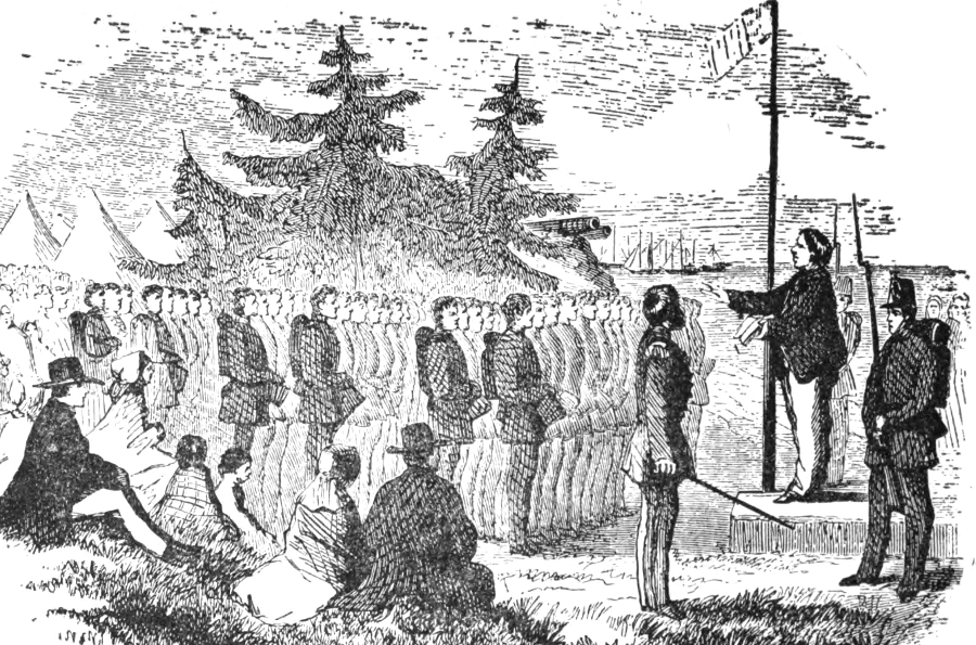
Rev. Joshua Thomas preached to the British soldiers in 1814 on Tangier Island, defiantly predicting their attack on Baltimore would fail
Source: The Parson of the Islands (p.45)
southern tip of Tangier Island where Joshua Thomas preached in 1866, before it eroded away
Source: National Oceanic and Atmospheric Administration (NOAA), Historical Map and Chart Collection, Chesapeake Bay, Potomac Entrance Tangier And Pocomoke Sounds. Sheet No. 3 (1866)
There are two churches today on Tangier. Swain Memorial United Methodist Church was divided in 1946 by a schism. The minister's theology drifted away from standard Methodist beliefs. He and a portion of the congregation started a separate congregation. The New Testament Church continues today, and is still unaffiliated with a particular denomination.
The split was not a happy one. The new church was vandalized with paint and excrement smeared on the walls, and the minister's boat was sunk twice. Since then, emotions have cooled and the separate churches now sponsor joint events occasionally.
The island community retains strong conservative values regarding what behavior is appropriate. In 1998, Tangier Island residents rejected a proposal by a Hollywood studio to film "Message in a Bottle" there. They passed up significant economic benefits because the alcohol, sex and profanity in the movie were inconsistent with island values. Despite an economic focus on tourism, no alcohol sales are authorized; Tangier Island is dry.9
After the railroad reached Crisfield, Maryland in 1866, the demand for seafood increased because watermen could ship fresh seafood quickly to New York.
After World War I, a shirt factory briefly operated on the island, taking advantage of the large number of women who had few other opportunities for work. At one time, there were 2,000 residents living on at least six separate ridges. Today, only three ridges remain populated, and there are closer to 500 residents. Tangier is the only island in Virginia with a permanent population which lacks a bridge to the mainland.
To provide prescription medicine to patients in the most isolated community in Virginia, Riverside Shore Memorial Hospital started a drone delivery program. After nearly two years of planning, on October 23, 2024 a drone completed a 17-mile "Beyond Visual Line of Sight" test flight from the hospital location on the Eastern Shore to Riverside Tangier Medical Center on Tangier Island. The next step was to scale up the technology to provide routine service, and to implement it in other rural areas to enhance health care.
The Virginia Department of Emergency Management arranged for assistance from Maryland in 2026, when ice in the Chesapeake Bay prevented the mail boat and passenger ferry from getting from Chrisfield to the island. At the same time, frozen snow on the airport runway interfered with landings. Drone service was still experimental.
Maryland's Eddie Somers, stationed at Crisfield, carved a path through ice for the fuel boat to reach the dock. The icebreaker also brought food, medicine, mail, and other supplies and transported people to doctor's appointments.10
bridges cross marshes and saltwater channels (guts) to connect the three populated ridges
Source: US Geological Survey (USGS), The National Map
Fishing, crabbing, and oystering still provide seasonal employment, especially raising soft shell crabs in shanties built on the harbor's waterfront. Other jobs are based on catering to tourists who come to see a unique location and to experience the unusual dialect spoken by islanders.
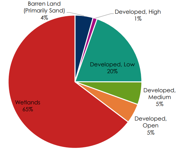
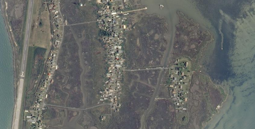
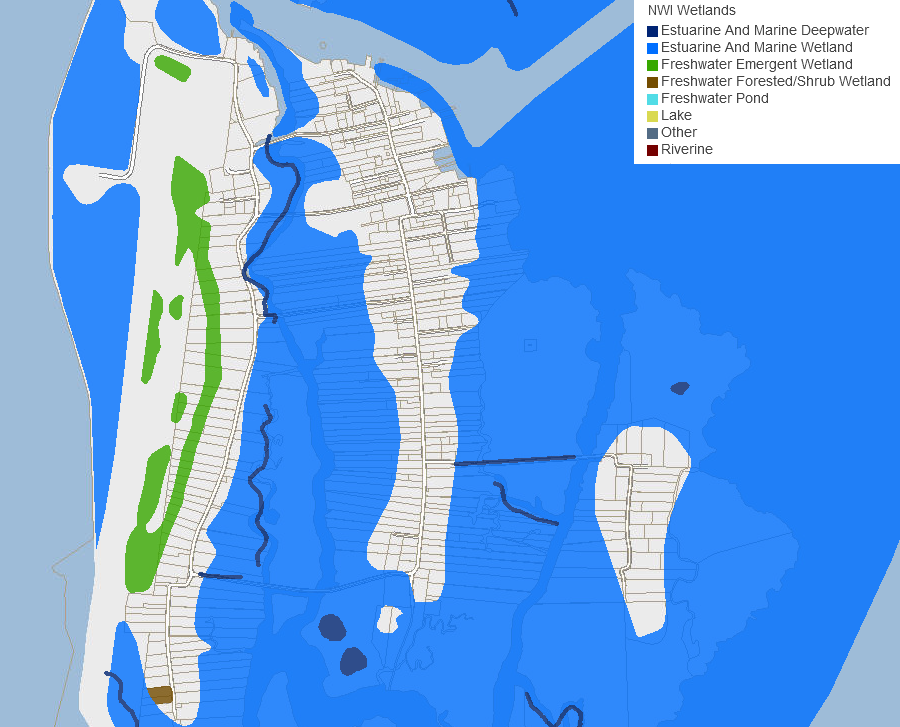
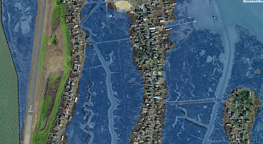
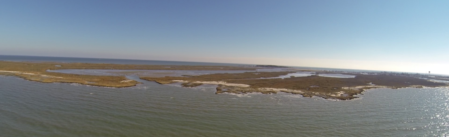
wetlands dominate the land cover on Tangier Island
Source: Accomack-Northampton Planning District Commission, Eastern Shore Hazard Mitigation Plan 2016 (Chapter 25, Page 9)
Claims that the local speech patterns are a relict of Elizabethan English may help attract some tourists, though Tangier Island was probably not settled until a century after Elizabeth I died. The idioms and stretched-out vowel sounds developed and were retained because the culture was isolated; few people moved to the island to work in a traditional water-based job. Most pronunciations (such as "ort" for "ought") and idioms (such as "in the sweet peas" meaning asleep), were created locally rather than inherited from England.
As modern transportation and telecommunications breaks down the isolation, the distinctive island speech is expected to disappear.11
Modern transportation helps the islanders survive. Starting in 1979 until he died in 2010, Dr. David B. Nichols would fly his airplane or helicopter to the island from White Stone in Lancaster County to provide volunteer medical care. His service earned him recognition as the Country Doctor of the Year award in 2006, and the local name of "Dr. Copter."
To ensure the care would continue, he helped an island resident get trained as a physician assistant and partnered with the Riverside Health System in Newport News to set up the Tangier Island Health Foundation. After the death of Dr. Nichols, Riverside Health System continued the pattern of flying a doctor to the island once a week, and budgeted $90,000 a year for the flights.
In 2023, Riverside Health System started delivering prescription medicines to patient's homes on Tangier Island via drones. The hospital partnered with a drone delivery company based in Virginia Beach, DroneUp. It was one of the first six companies in the United States to obtain an FAA Part 119 air carrier certificate under Part 135. That allowed transporting third-party packages by drone for up to 5 miles, and removed the requirement for the drone operator to keep it within a visual line of sight.
DroneUp focused on establishing delivery services in Dallas/Fort Worth as its first large market, but the company planned a $20 million facility for testing and training, along with research and development center, at Richard Bland College in Dinwiddie County.12
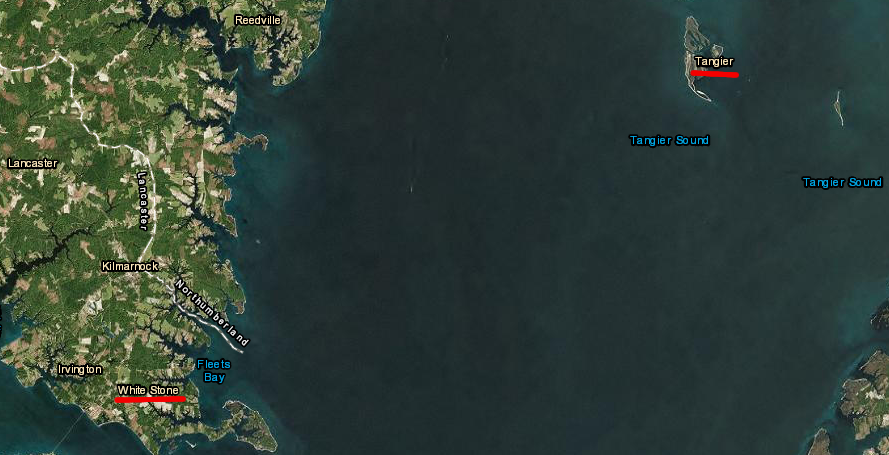
between 1979-2010, "Dr. Copter" flew weekly from White Stone in Lancaster County to provide medical services to residents on Tangier Island
Source: ESRI, ArcGIS Online
Helicopters also bring medicine and emergency supplies to the island when ice in the Chesapeake Bay stops boat traffic. In the winter of 1977, when almost the entire Chesapeake Bay froze; ice was 1.5-2 feet thick in many places.
Floating blocks of ice made it hard for pilots to get onto ships at Cape Henry. Their services were especially valuable because ice had dislocated all the buoys marking the shipping channels, and there was no Global Positional Service (GPS) capability for commercial ships in 1977. An Exxon tanker chose to stop at the mouth of the Rappahannock River, south of Tangiers Island, to wait for daylight before traveling north. When the ship dropped its 10-ton anchor, it just bounced off the frozen ice surface of the Chesapeake Bay.
The Virginia National Guard provided a delivery service again in 2015 and in 2018, when the normal ferry service was unable to dock at Tangier Island. Volunteer pilots also arranged in 2018 to bring MeowMix and other food for the local cats, which may exceed the number of people on the island.13
The Town of Tangier was incorporated in 1915. Residents vote in both town and Accomack County elections. For county elections, the island is part of Magisterial District 6, which also includes the Town of Onancock.
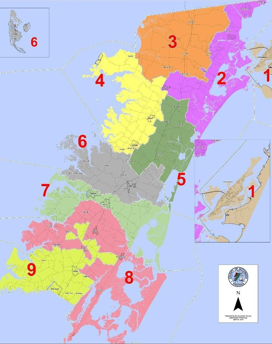
in Accomack County, the Town of Tangier is part of Magisterial District 6
Source: Accomack County, Election District Map
Electricity arrived in the 1920's. A diesel generator produced direct current, which required special converters to run standard appliances at houses. The generator ran for only a few hours each evening, providing power for street lights. It failed in 1944, leaving the island without electricity.
Henry Jander, who moved with his family to Tangier that year, failed in his initial effort to get the Rural Electrification Administration to provide replacement generators. He then the organized the islanders and raised enough funding for a new power plant, an amazing accomplishment in a community of strong individualists. However, he could not obtain war surplus generators.
The Rural Electrification Administration agreed to combine the needs from both Tangier and Smith islands, so the islanders sold the building intended to house the generators to the Chesapeake Islands Electric Cooperative. The co-op began selling electricity to islanders in 1947. To get electricity to Smith Island, poles were driven into the bed of the Chesapeake Bay and a power line strung on them. Years later, one Tangier waterman was almost electrocuted when he brushed against the wire on Goose Island.
In 1977, an underwater power cable connected Tangier to Eastern Shore. The diesel generators installed by Henry Jander were then retired.
the route of the electrical cable between Tangier and Smith islands is stil marked on nautical charts
Source: National Oceanic and Atmospheric Administration (NOAA), Booklet Chart: Chesapeake Bay - Pocomoke and Tangier Sounds, NOAA Chart 12228
Sewage waste is moved through an underground sewer and processed at a town-operated treatment plant. Solid waste management challenges are unique for the populated island. In 1993, the presence of an unsightly dump drew media attention. News articles contrasted the advertising used to attract tourists to the "largely unspoiled" island with the reality of the pile of waste.
The town now collects and incinerates most garbage. Items not suitable for burning, such as kitchen appliances, are still stockpiled at a temporary dump. Several times each year, ash from the incinerator and the stockpiled large items are barged to the Eastern Shore and trucked to the Northern Landfill.
Drilling wells in 1960 to obtain drinking water, replacing cisterns on the roofs used to capture rainwater, was surprisingly difficult on Tangier Island. The impact of a "bolide" (comet/meteor) 35 million years ago created a crater that disrupted sedimentary formations that would normally served as aquifers supplying fresh water. Extra-deep wells had to be drilled to mine ancient water from the Potomac Aquifer, rather than extract water from a shallow aquifer recharged by rainfall:14
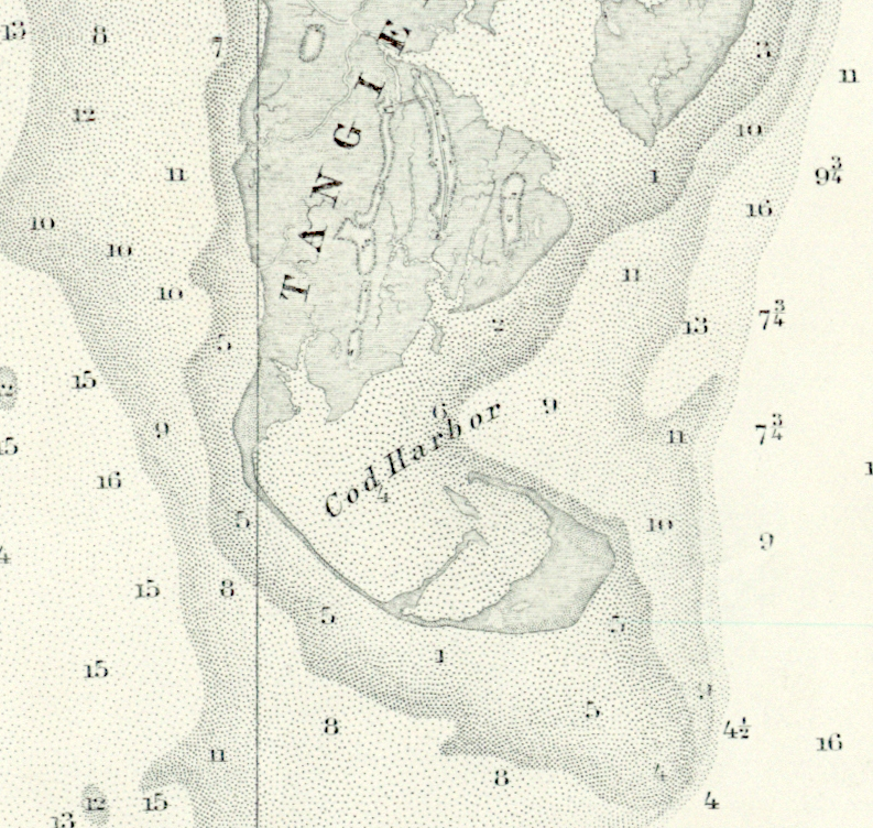
In 1917, the US Government dredged the boat basin in what is now Main Channel, and dug the channel on the east side in 1921. That channel is maintained by the Corps of Engineers at 8' depth. The 7' deep channel on the west side (known as North Channel) was carved through the former location of Oyster Creek in 1967, with the dredged materials used to create the land for the island's airport.15
navigation channels and the main harbor were carved through Tangier Island between 1917-1921
Source: US Geological Survey (USGS), National Map
Population changes reflect the changing economics of harvesting crabs, oysters, and fish, plus the challenge of maintaining house sites as the island washes away. Even before the oyster population dropped precipitously due to diseases (Dermo and MX) and overharvesting, erosion reduced the suitable living sites and made it harder for families to stay on the island.
when tongers faced competition from dredgers after the Civil War, competition for oysters increased and the Oyster Wars began
Source: Library of Congress, Oyster tongers fishing from side of boat, Chesapeake Bay, Md., U.S.A.
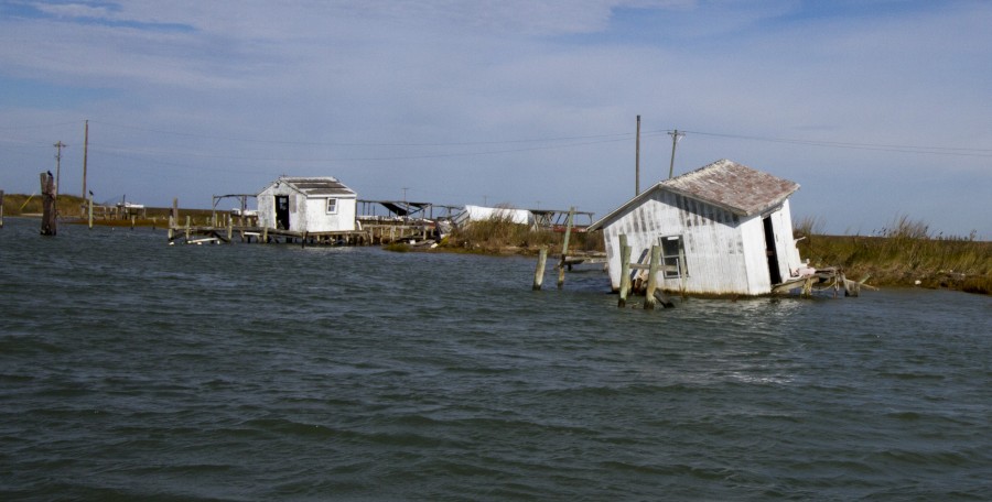
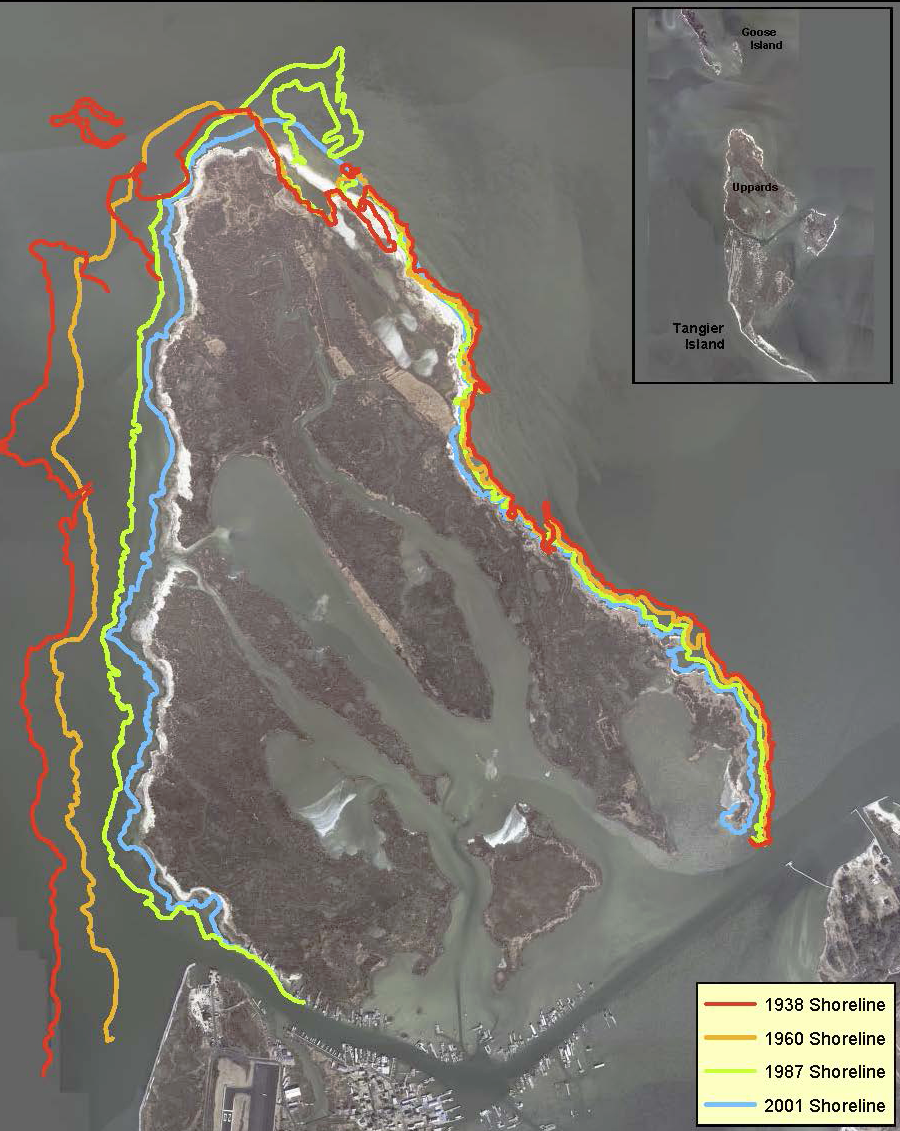
The communities on the "Uppards" (upwards) portion of Tangier north of the harbor (Canaan Ridge, Oyster Creek, Persimmon Ridge and Reubentown) were abandoned in the 1930's due to flooding. Some houses were relocated to the south, but graveyards were left in place. That portion of Tangier Island is now estuarine wetlands and no longer offers any locations suitable for houses.
Continued erosion on the Uppards is exposing burials from historic cemeteries. In Chesapeake Requiem, Earl Swift wrote of a local resident visiting the area known as Canaan at the northern tip:16
Across the island, new graves are raised above ground level due to the high water table. On Canaan, the shoreline is eroding south at a rate of 15' annually. All of the Uppards is predicted to be underwater by the year 2063, and the impact of change over time on the cemeteries draws regular attention. After Superstorm Sandy in 2012, a Corps of Engineers scientist visited the area and commented later:17
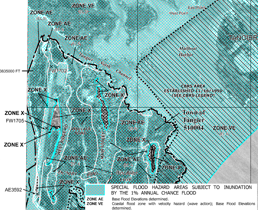
only tiny portions of Tangier Island are classified as Zone X, elevated above the 100 year flood plain
Source: Federal Emergency Management Agency (FEMA), Flood Zone Map (area number 51001C0380F)
The land is sinking, while sea level is rising. Tangier Island is outside the crater formed by a bolide 35 million years ago, but the land throughout the bay region is getting lower. One theory is that the ice sheets that covered the North American continent, down to Pennsylvania, compressed the land beneath the ice - but the pressure further inland squeezed up the Coastal Plain of Virginia.
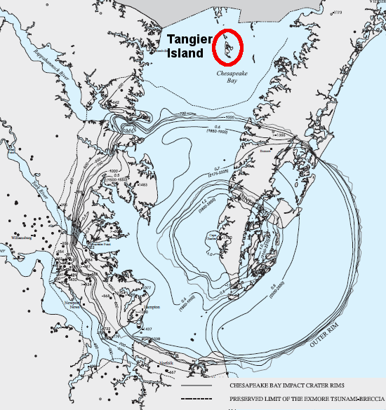
a 35-million year old bolide crater triggers unusual land subsidence to the south and does not affect the island - but Tangier is still affected by the regional land subsidence resulting from the melting of the ice sheets
Source: US Geological Survey (USGS), The Effects of the Chesapeake Bay Impact Crater on the Geological Framework and Correlation of Hydrogeologic Units of the Lower York-James Peninsula, Virginia (Plate 6A)
The ice sheet has melted and the continental crust on the eastern edge of North America is rebounding - and that rebound is pushing down the coastline of Virginia, causing land levels around the Chesapeake Bay to sink. At the same time, sea levels are rising worldwide. For Tangier Island, the combination of sinking land and rising water levels indicates the island's remaining existence will be short.
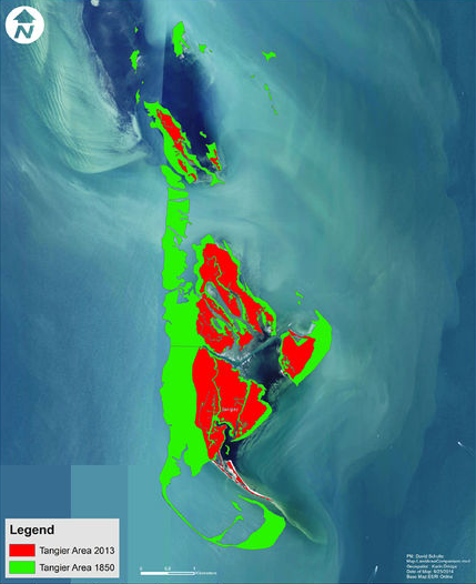
By some scientific estimates, 75% of the land that formed Tangier Island in 1850 disappeared by 2015. Less than 10% of the remaining land above water is habitable now.
Accomack County has mapped wetlands on Tangier Island
Source: Accomack County, AccoMap
houses on Tangier Island are on the higher ridges, not in the lower wetlands
Source: Accomack County, AccoMap
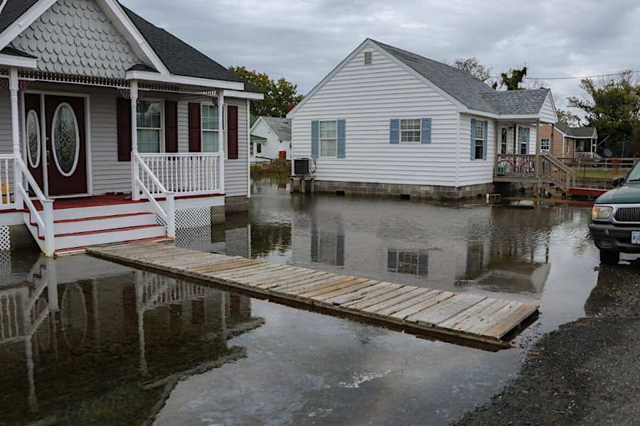
In 1821, a hurricane flooded the island with water three feet deep. In the August 23, 1933 Chesapeake and Potomac Hurricane, the entire island was covered with water deep enough to flood the entire first floor of some structures.
In a Category 1 hurricane, 75% or more the island could be inundated by the storm surge, as occurred in 1899 and 1984. The Base Flood Elevation is below 5', and 86% of all houses are located in the 100-year flood plain. All roads will be covered by salt water if a storm raises sea level one foot above mean higher high tide.
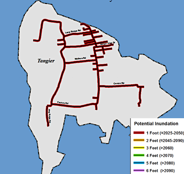
all three miles of roads on the island will be flooded by a one foot rise in water level above mean higher high tide
Source: Accomack-Northampton Planning District Commission, Eastern Shore of Virginia Hazard Mitigation Plan (Chapter 25, Figure 2)
Roughly 7-9 acres erodes away annually, and the entire island could be underwater in 50-100 years. Fort Albion is already 10' underwater. The seven ridges that were high enough for houses prior to 1900 shrank to six ridges by 1930, and now just three ridges are occupied.
Not surprisingly, local residents are very conscious of the rising sea levels, though the relative role of human actions causing the change is debated. Local residents contend that Tangier Island is being worn away by waves and tidal actions, and the problem is erosion rather than sea level rise.
Erosion destroyed Sharpes Island in the Chesapeake Bay, once located at the mouth of the Choptank River. That island was the model for "Devon Island" in the historical novel Chesapeake, written by James Michener. When seen by John Smith in 1608, the island may have been 1,400 acres in size with ridges seven feet above sea level. By 1954, Sharpes Island had disappeared. Today, the site is a shoal five feet underneath the surface of the Chesapeake Bay.
However significant the impacts of erosion, if relative sea level rise continues at nearly five millimeters a year then Tangier Island is likely to become uninhabitable by the year 2050. As described by one resident:18
in the last century, water has covered the southern hook of land where Fort Albion was built and Methodist camp meeting were held between 1809-1857
Source: Library of Congress, A map of the state of Virginia, constructed in conformity to law from the late surveys authorized by the legislature and other original and authentic documents (by Herman Boye, 1859)
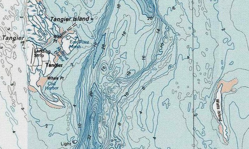
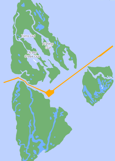
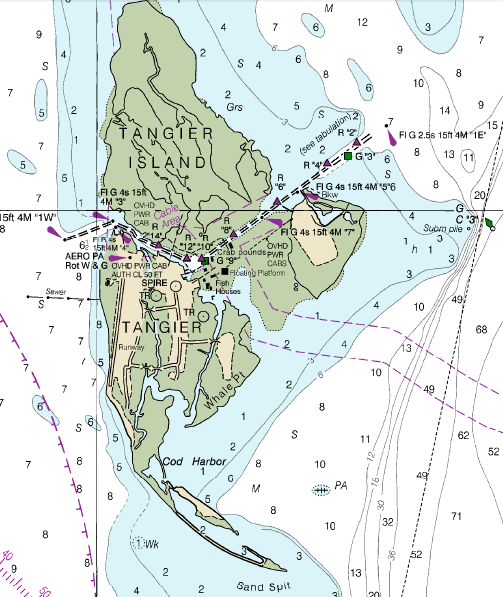
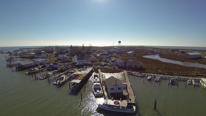
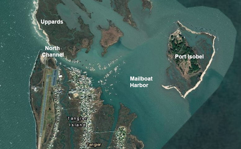
The Corps of Engineers has dredged two channels to ensure commercial and recreational boat access to the town harbor. The 3,820-foot long North Channel, maintained at a seven-foot depth, goes northwest from Mailboat Harbor to the Chesapeake Bay. Another channel, maintained at an eight-foot depth, goes 6,000 feet east to connect Mailboat Harbor to the Tangier Channel.
the Corps of Engineers dredged out Mailboat Harbor with a channel to the east, then later added North Channel to the west
Source: ESRI, ArcGIS Online
Mailboat Harbor itself is dredged to maintain a depth of seven feet. Commercial fishing vessels based at Tangier harvest blue crabs in particular, and require water depths between two feet to six feet.
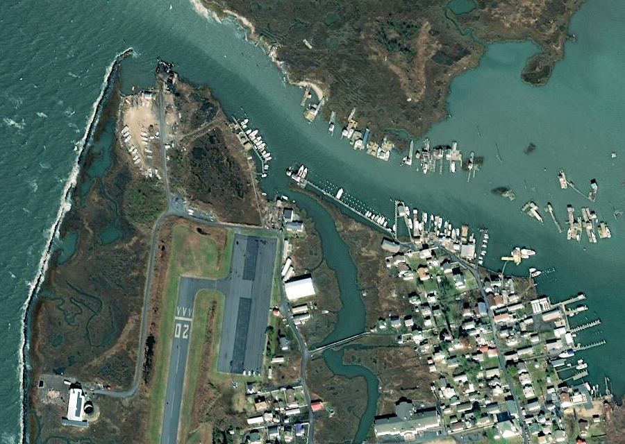
Tangier Island depends upon its harbor for moving people and cargo
Source: Virginia Department of Transportation, Bridges and Culverts
In 1990, the Federal agency built a 5,700-foot stone riprap seawall on the west side of the island to protect the airstrip built in 1969 and the wastewater treatment plant. The project was mandated by Congress, even though the benefit-to-cost ratio was below 1.0. The economic benefits were less than the cost of the seawall, but legislation stated:19
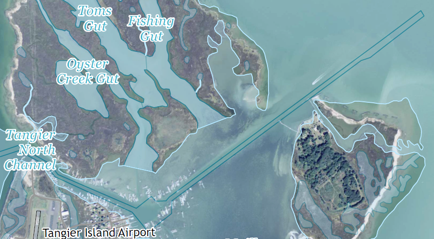
the Corps of Engineers constructed a navigation channel between Uppards and Tangier Island in 1967
Source: US Geological Survey (USGS), 7.5-minute topographic map for Tangier Island, VA (2016)
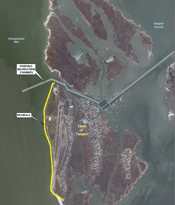
the seawall on the western side of Tangier Island protects the airport
Source: US Army Corps of Engineers, Tangier Island Jetty Section 107 Detailed Project Report (Figure 3)
Between 2001-2013, the Corps of Engineers identified how eight breakwaters placed on the shoreline could protect 1,300 acres of the Uppards. Further design and construction required funding from the Town of Tangier. The project stalled without that funding.
The seawall protected the portion of Tangier Island with the airport. North of the shipping channel, severe erosion (16 feet/year) on the western edge of the Uppards resulted in the continued conversion of land to shallow open water habitat.
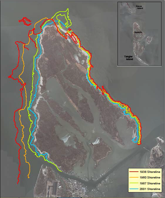
erosion has shifted the shoreline more on the western vs. eastern side of Tangier
Source: US Army Corps of Engineers, Tangier Island Jetty Section 107 Detailed Project Report (Figure 4)
In 2012, after Superstorm Sandy, Congress agreed to fund a $4.2 million project to build a stone jetty on the northern end of the seawall and the southern end of the Uppards. The intent was to reduce erosion of the island, and increase navigability in the Tangier North Channel.
Such a project had been "authorized" in 1994 and then studied in more detail. Congress chose not to provide funding, however, after studies showed a benefit-to-cost ratio of just 0.5 - meaning $4 million in costs would provide just $2 million in benefits.
The jetty project was one of many that had been proposed, including one by the local representative to the US Congress to sink barges and create a low-cost breakwater. Access to the Chesapeake Bay is essential to the island's economy. When plans for the jetty were announced, Tangier had about 500 residents and 125 were licensed commercial watermen.
the new jetty will maintain access to the shipping channel
Source: ESRI, ArcGIS Online; US Geological Survey (USGS) National Map Viewer
Supporters hoped the jetty might be completed by 2017, but the approval and final funding processes were not that swift. The Corps studied five alternatives:
(1) revetment
(2) revetment with a jetty
(3) offshore breakwaters
(4) geotextile tubes
(5) relocation of harbor facilities
The jetty was the only one with a benefit-to-cost ratio greater than 1.0. A revetment (a sloped wall on the shoreline, armored with rock) and breakwaters (stabilization structures made from piles of rock located near the shoreline) would not provide ant protect boats in the harbor against wave action.
Geotextile tubes (geosynthetic sheets filled with sand) placed along the shoreline could protect against some wave action, but not the intensity of waves that strike Tangier. Relocating the harbor would be prohibitively expensive, even if a better location could be found.
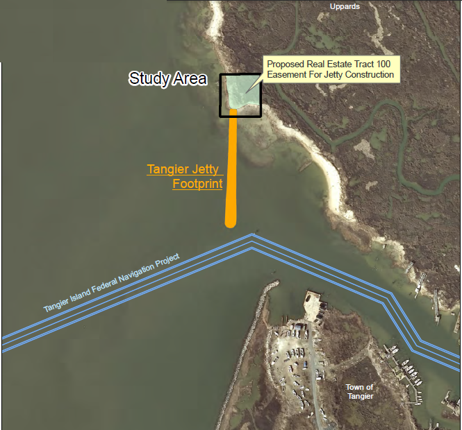
$2.6 million in funding for a new jetty, extending south from Uppards, was announced in 2018
Source: US Army Corps of Engineers, Real Estate Plan, Tangier Island Jetty Cap Section 107 Project (Exhibit A, Site Map)
In August 2018, the Federal and state government announced plans for a $2.6 million project to build the 494-foot stone jetty the southern end of the Uppards, with the Federal government providing 80% of the funding and the state providing 20% ($495,000).
Timing of the approval was convenient for the Congressional Representative for the area. Rep. Scott Taylor was in a tight race. He belonged to the same political party as the President, so the announcement of the decision helped cement support for his re-election. Virginia's governor belonged to the other political party, so support for Tangier Island's jetty crossed partisan political boundaries.20
the US Army Corps of Engineers dredges the shipping channel between Tangier and Uppards islands
Source: National Oceanic and Atmospheric Administration (NOAA), Bathymetric Data Viewer
Tangier Island
Source: National Oceanic and Atmospheric Administration (NOAA), Chesapeake Bay Pocomoke and Tangier Sounds (Chart 12228)
Despite the jetty, sinking land/rising seas may ultimately force evacuation of the island, just as Holland Island was abandoned in the 1920's before it disappeared. That triggered a columnist for the Virginian-Pilot to propose in 2014 to abandon the jetty and use the $4.2 million to give everyone on the island $8,400 to pay for moving costs.21
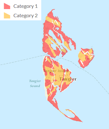
storm surges from Category 1 and Category 2 hurricanes will inundate Tangier
Source: Virginia Department of Emergency Management, Virginia Hurricane Storm Surge Tool
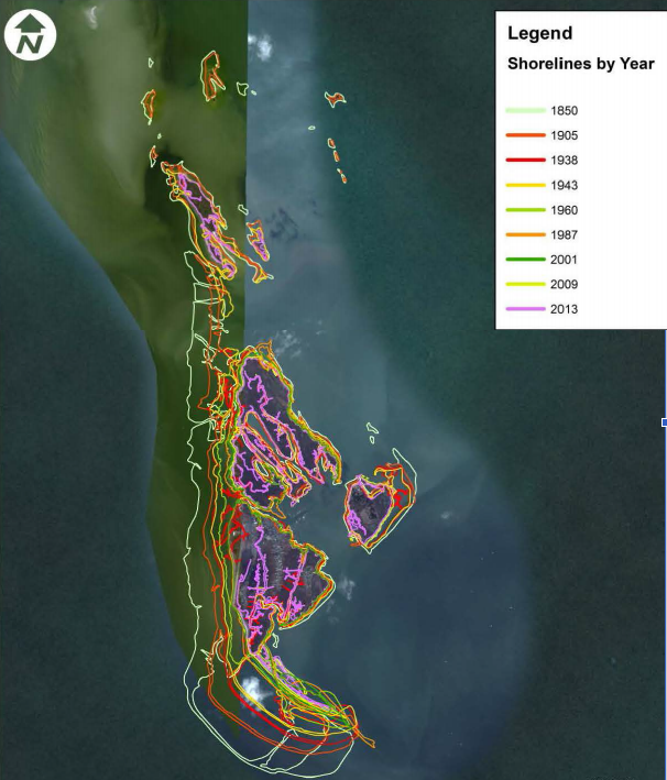
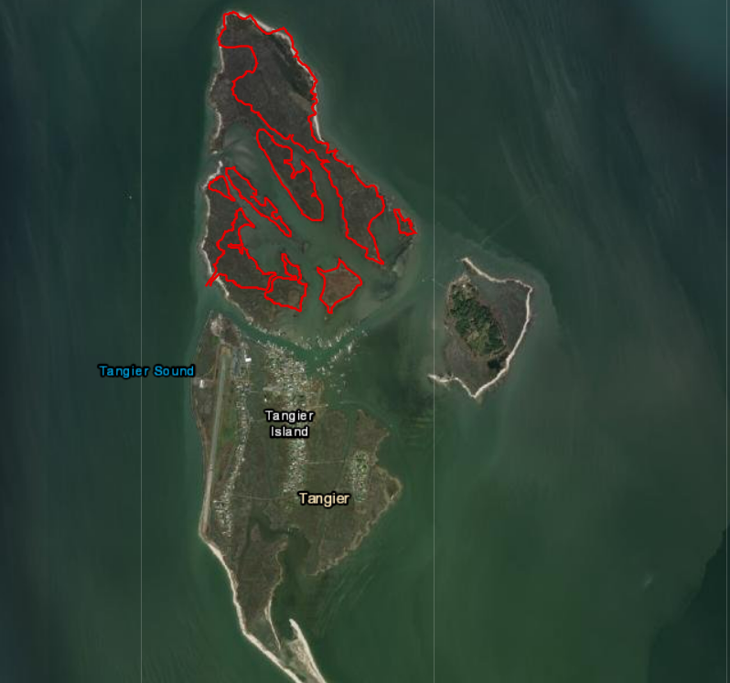
In 2015, a scientific report titled "Climate Change and the Evolution and Fate of the Tangier Islands of Chesapeake Bay, USA" concluded that since 1850, about two-thirds of Goose, Uppards, Port Isobel and Tangier Island have become uninhabitable. Basically, Tangier Island today is 1/3 of its size in 1850; the trend line is clear.
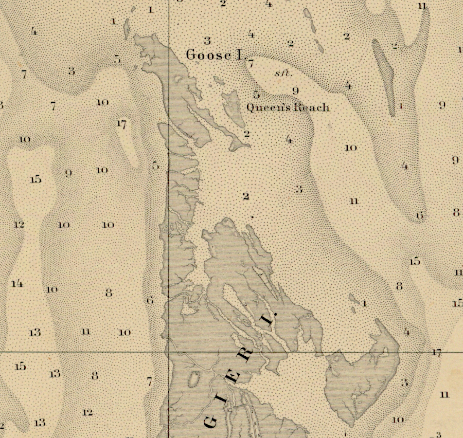
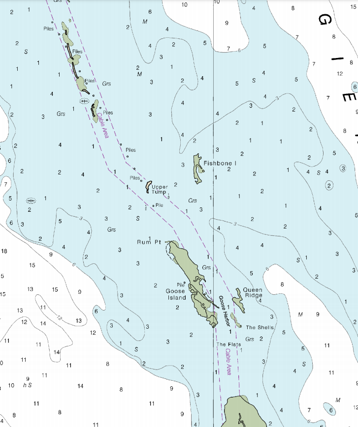
Goose Island was almost connected to Tangier Island in 1872
Source: National Oceanic and Atmospheric Administration (NOAA), Historical Map and Chart Collection, Chesapeake Bay Sheet No. 3 Potomac Entrance Tangier and Pocomoke Sounds Sheet No. 3 (1872)
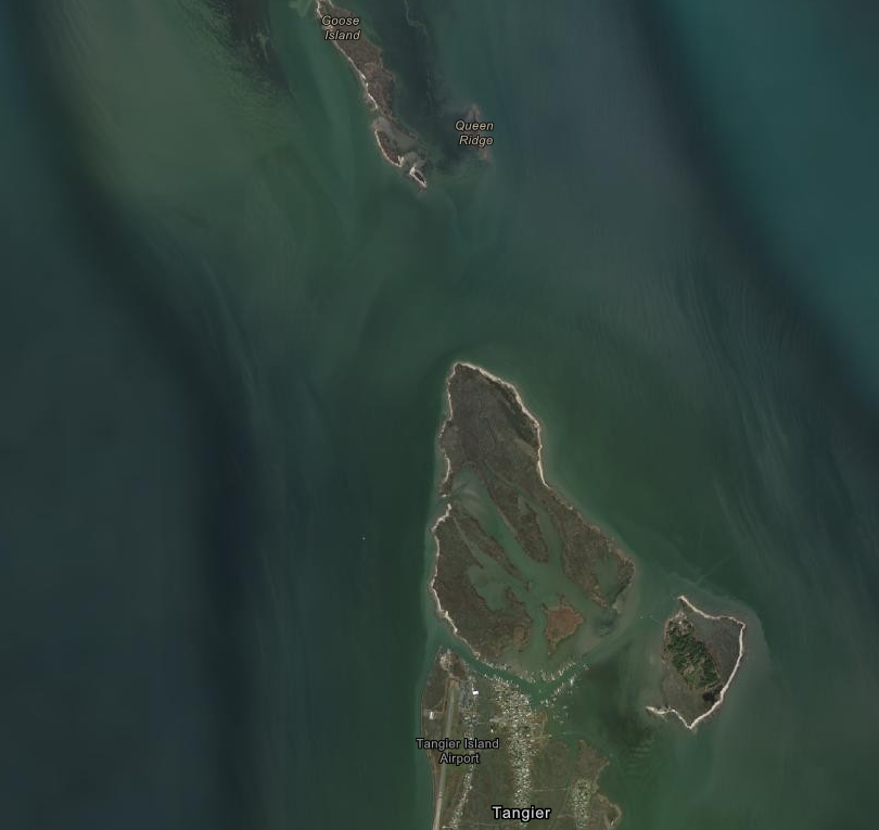
much of Goose Island has disappeared since 1850
Source: ESRI, ArcGIS Online
Relative sea level rise eroded away the land or submerged it, converting uplands into marshlands or open water. Since 1600, over 500 islands in the Chesapeake Bay have been lost. The US Army Corps of Engineers has tried to minimize land loss at the Uppards portion of Tangier Island. When the Corps dredges the shipping channel, it dumps the spoils at a spot on Uppards where a breach allows salt water to intrude inland.
The most ambitious proposal to "save" the island is to convert it into a dredge spoils storage facility. Poplar Island in Maryland was disappearing until the U.S. Army Corps of Engineers, the Maryland Department of Transportation, and the Maryland Port Administration began dumping dredge spoils there. What was a 1,140-acre island in 1846 had eroded down to just four acres in 1994, but is now over 1,000 acres in size. Poplar Island will regrow to 1,715 acres by 2044.22
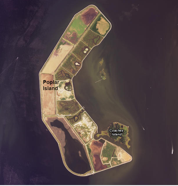
one option for preventing land loss at Tangier Island is to make it a dredge spoil disposal site, like Poplar Island in Maryland
Source: ESRI, ArcGIS Online
between 2019-2044, Poplar Island will grow by another 700 acres
Source: Maryland Environmental Service, About Poplar Island
Currently the mud, silt, and sand from dredging of the Baltimore shipping channels between Poplar Island and Craney Island are barged away and disposed of by "unconfined open water overboard placement of materiel." In other words, the spoils are dumped into Chesapeake Bay somewhere away from the shipping channels.
That process smears a layer of silt on the bottom of the bay, damaging the habitat of blue crabs and other wildlife. Transporting the spoils to a dredge spoils storage facility at Tangier Island would improve environmental conditions for fish and wildlife, as well as maintain Tangier Island's existence.
Further south, sediments dredged from the shipping channels at Hampton Roads are deposited in the equivalent Craney Island Dredged Material Management Area.
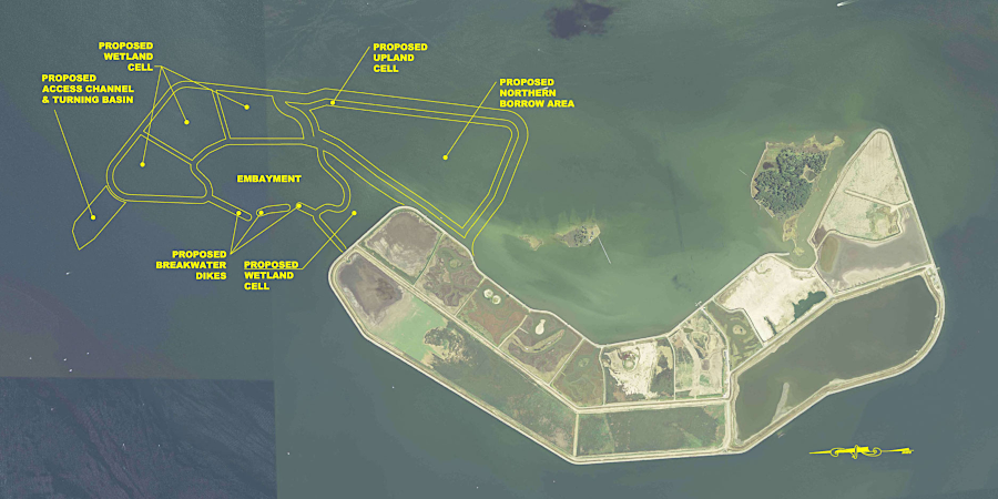
Converting Tangier Island into a dredge spoils storage area would require the US Congress and State of Virginia to make a major funding commitment, in the hundreds of millions of dollars. The future Tangier Island would look dramatically different from the present place.
The natural boundaries of the island would be replaced by earthen walls, and dredged materials would be pumped into cells between the walls. Tangier Island would grow to about 50' in height after decades of dumping and become a haven for seabirds in the bay.
Local residents have expressed support for the proposal, even though all the current structures on the island would have to be moved at some point and the distinctive island culture might be transformed. The alternative to an island re-engineered by humans, with a dramatically different appearance, is to watch Tangier Island just disappear.
In 2016, the Virginia Marine Resources Commission submitted a proposal to the Corps of Engineers to study the option:23
Tangier residents noted that on the Uppards, trees were still growing on dry land that had been raised by the deposition of dredge spoils in the 1960's. In 2025 a town official endorsed raising the elevation of Tangier Island with more dredge spoils, comparable to how Maryland used the material excavated from the Baltimore shipping channel to expand Poplar Island:24
Uppards portion of Tangier Island, where the Corps of Engineers has tried to block water from flowing into interior of the island
Source: US Army Corps of Engineers, Norfolk District Image Gallery
In addition to absolute sea level rise raising water levels, Tangier Island is sinking. Up to half of local land subsidence was caused by compaction of the aquifer after groundwater was pumped up 900 feet to the surface for use by residents on the island. The remainder of the subsidence was due to glacial rebound from the retreat of Laurentide Ice Sheet over the last 18,000 years, and by the lingering effects of a nearby bolide (meteor/comet) impact 35 million years ago.
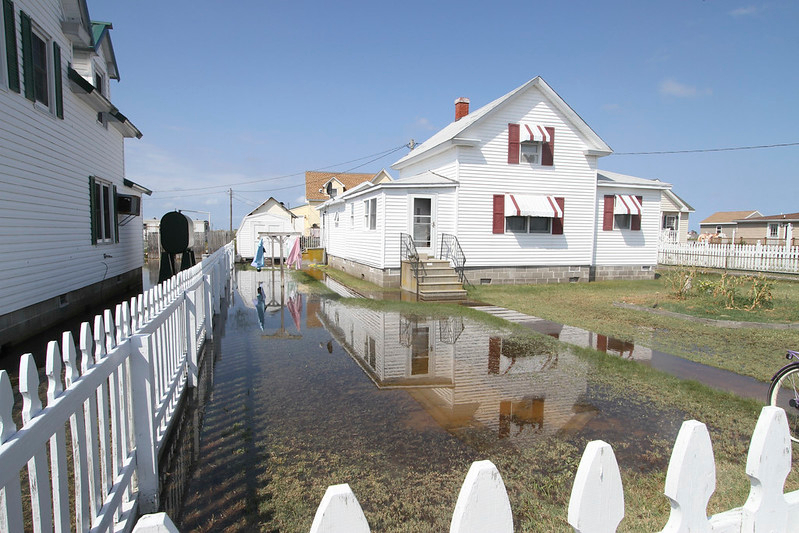
tidal flooding at Tangier Island on September 16, 2016
Source: US Army Corps of Engineers, 160916-OI229-A-009
The "Climate Change and the Evolution and Fate of the Tangier Islands of Chesapeake Bay, USA" report concluded:25
since 1850, 2/3 of the land of the land at Goose, Uppards, Port Isobel and Tangier Island has been submerged or converted into marsh
Source: Scientific Reports, Climate Change and the Evolution and Fate of the Tangier Islands of Chesapeake Bay, USA (2015)
In 2017, CNN broadcast a program on the impact of rising sea levels on Tangier Island. President Trump then called the mayor of the island, reassuring him that the island would survive for hundreds of year more.
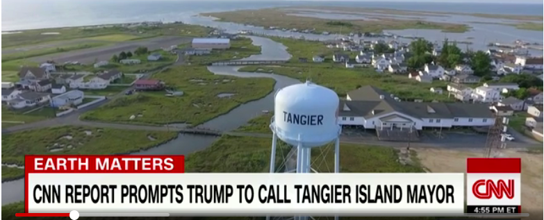
risks to Tangier Island became national news in 2017 when President Trump called
Source: CNN, CNN report prompts Trump to call mayor of disappearing island
That claim generated more attention, since President Trump had announced two weeks earlier that the United States would withdraw from the international Paris Accord on climate change. It also triggered speculation that the Trump Administration would propose funding a seawall, behind which dredged material would be deposited to raise the elevation of the island.
One resident noted that the debate over climate change was not a significant factor in the 2016 presidential election, in which Trump won 87% of the vote on Tangier:26
all Tangier Island structures are at risk now
Source: US Army Corps of Engineers, Norfolk District Image Gallery
The occupied portion of Tangier Island was excluded from the Coastal Barrier Resource System when it was created in 1982. Only undeveloped land was added to the system, which limits development by prohibiting use of Federal funding for new development. The US Fish and Wildlife Service classifies Port Isobel as Other Protected Area, because it is privately owned but managed by the Chesapeake Bay Foundation for conservation purposes.27
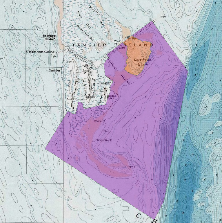
Port Isobel and the undeveloped southern part of Tangier Island is included within the Coastal Barrier Resources System
Source: US Fish and Wildlife Service, CBRS Projects Mapper
The local, state, and Federal governments may decide that the costs to armor the shoreline and raise the elevation of Tangier Island exceed the benefits, and implement a plan to retreat from the site. If so, residents of Tangier Island will not be the first climate refugees to be evacuated from their homes due to sea level rise.
98% of the Isle de Jean Charles in Louisiana disappeared underwater after 1950. In 2016, the Federal government committed nearly $50 million to resettle the remnants of the Biloxi-Chitimacha-Choctaw band from their homes there. Moving the group 40 miles inland was designed to protect them from flooding, but inevitably cut them off from the bayou and disrupted their cultural traditions.
A comment about protecting Tangier Island so 400 or so residents can remain there revealed the scope of the challenge. Sea level rise is occurring across the planet, and 200 million residents in threatened waterfront areas worldwide may be more concerned more about their places and cultures than about Tangier Island:28
Any proposal to evacuate Tangier Island will have to deal with substantial social impacts and concerns about loss of identity. Many are related, with last names of Parks, Pruitt, Thomas, Crockett, and Charnock. Island residents generate substantial income from tourists, but do not welcome strangers into their community life. The author of one magazine article noted:29
The relative isolation of the 700 acres of Tangier Island, with 12 miles of water between it and the Eastern Shore, was beneficial when the COVID-19 disease spread across Virginia in 2020. No cases were identified on the island even during the Summer tourist season, and the islanders were relaxed about wearing masks and maintaining a "social distance" though the Fall. The mayor commented before the first cases were discovered at the end of 2020:30
It was unclear how the infection reached the island, but the residents assumed it spread from pre-Thanksgiving service at the New Testament Church. Gatherings at the post office or grocery store could also have been significant, but the community responded with a self-imposed lockdown. Everyone chose to wear masks, and community gatherings - including church services - were cancelled.31
The COVID-19 pandemic demonstrated the need for high-speed internet connections. The Eastern Shore of Virginia Broadband Authority installed fiber on the island in April, 2021. No fiber was installed underwater; instead, microwave dishes on the water tower were aligned to dishes on the mainland. For the fiber-laying operation, installers used gasoline-fueled equipment. On an island that used golf carts for most transportation, advance logistical planning was required to barge all vehicles and other equipment to Tangier.
Tangier was the last of the 19 incorporated towns on the Eastern Shore to get a broadband connection.32
Source: Chesapeake Conservancy, Tangier Island
Investment in new infrastructure for Tangier might have a short time to provide benefits. A 2021 assessment noted that two-thirds of the islands landmass had disappeared since 1850 and predicted complete conversion of the island to wetlands by 2051. Tangier was predicted to become another of the 500 islands in the Chesapeake Bay that had already disappeared due to erosion and sea level rise since English colonists arrived in 1607.
Formerly forested uplands and farmland had already disappeared, and unlike barrier islands Tangier had no significant source of sand for natural processes to rebuild the landmass. The process of conversion of uplands to wetlands was one-directional, and accelerating. The three ridges in 2021 had a limited life expectancy, and the study predicted that all uplands would be lost within three decades:33
Tangier uplands are being converted to wetlands, and houses on the three ridges are seeing higher floodwaters
Source: Virginia Department of Forestry, Can Trees Save a Sinking Island?
The study calculated the costs to ring the island with a nine-foot high seawall and pump sand onto the land would cost about $250-350 million. Abandonment was also predicted to be less expensive but still costly, involving up to $100-200 million in lost assets and moving costs for the 436 residents counted in the 2020 Census.
By 2024, the cost to build a seawall around Tangier Island and elevate infrastructure to reduce flooding was estimated to be $300 million. Cost to move all residents off the island was $200 million. Population had dropped 40% between 2012 and 2022, so cost per person for abandonment was about $500,000.
The prediction for the coming decades was bleak:34
Tangier Island in 1943
Source: US Army Corps of Engineers, Tangier Island VA (1943) and Tangier Island VA (1968)
The Virginia Department of Forestry partnered with local residents in 2021 to plant 150 eastern redcedar, southern bayberry, and live oak trees on the eastern shoreline to anchor the soil and reduce erosion. The state agency's story about the effort to increase resilience and extend the lifespan of the island was titled "Can Trees Save a Sinking Island?"35
The answer might be... no. However, in 2022 the US Congress appropriated $25 million for the use of dredge spoils from federal navigation projects to add material to the island. That will help offset the erosion from waves and currents, and raise the height of dry land to counter sea level rise.36
Source: Virginia Department of Forestry, Tree Planting on Tangier Island
Prognostications that the time for human occupation of Tangier Island was limited are now common. However, they did not stop the Virginia Department of Environmental Quality (DEQ) from awarding a $2.3 million grant in 2024 for the town to purchase the privately-owned petroleum storage facility on the island and to replace the tanks. The funding was intended to minimize the risk of an oil spill.37
Source: WAVY, Specal Report on Tangier Island (2023)
the Tangier Island shoreline has been shrinking since the first map was completed in 1850
Source: US Army Corps of Engineers, Water Resources Reform and Development Act (WRRDA) 7001 Submissions Package - Tangier Island (p.13)
looking south at Tangier Island from the harbor
Source: US Army Corps of Engineers, 151204-A-OI229-040
the patch of trees on Port Isobel, east of Mailboat Harbor, are located on fill that raised the land surface
Source: ESRI, ArcGIS Online
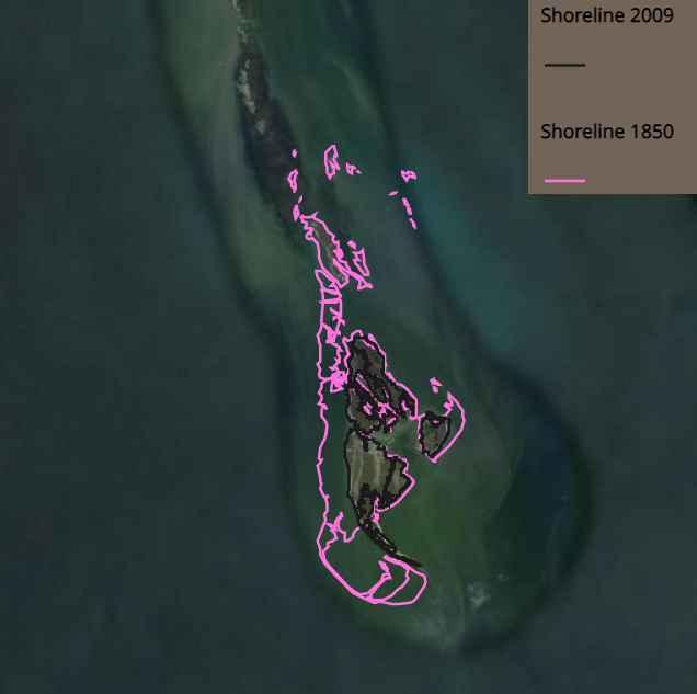
shoreline of Tangier Island has retreated from 1850 (pink line) to 2009 (black line)
Source: Virginian Institute of Marine Science (VIMS), Erosion Threatens Tangier Island
red line shows the small shoreline of Tangier Island projected to exist in 2063
Source: Virginian Institute of Marine Science (VIMS), Erosion Threatens Tangier Island
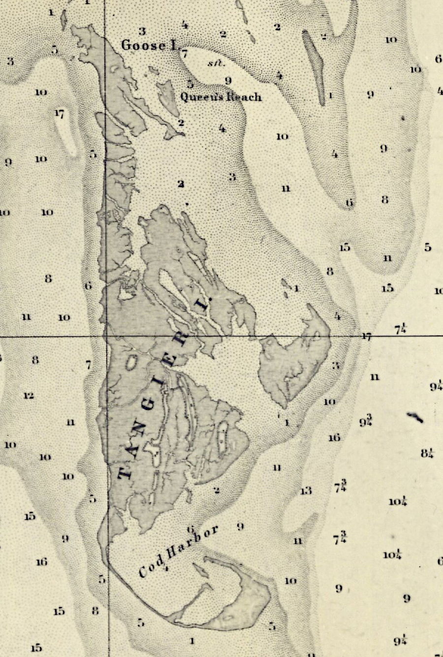
the series of islands originally mapped as the Tangier Islands are surrounded by shallow shoals, which impeded navigation but supported oysters
Source: Library of Congress, To the American Philosophical Society, this map of the peninsula between Delaware & Chesopeak bays, with the said bays and shores adjacent drawn from the most accurate surveys is humbly inscribed by John Churchman (1786)
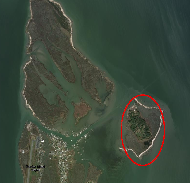
the Chesapeake Bay Foundation has an education center on Port Isobel (East Point Marsh)
Source: ESRI, ArcGIS Online
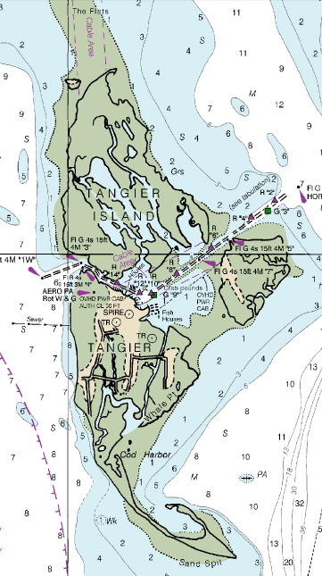
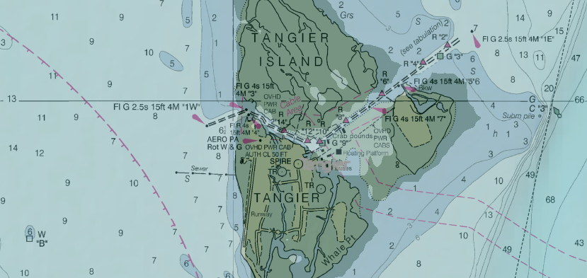
the Corps of Engineers dredges the channel on the east side of Tangier Island to maintain a depth of 8 feet, while the turning basin and west channel are maintained at 7 feet
Source: National Oceanic and Atmospheric Administration (NOAA), Chesapeake Bay - Pocomoke and Tangier Sounds, NOAA Chart 12228
a jetty on the west end of the channel was predicted to minimize erosion of the Uppards shoreline
Source: US Army Corps of Engineers, Norfolk District Image Gallery
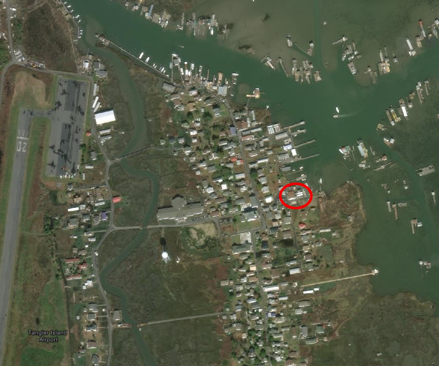
the electric plant on Tangier Island (red circle), where the cable from the Eastern Shore now comes ashore
Source: ESRI, ArcGIS Online
Tangier Island was much larger in 1863
Source: National Oceanic and Atmospheric Administration (NOAA), Historical Map and Chart Collection, Chesapeake Bay Sheet #3 Potomac Entrance Tangier and Pocomoke Sounds (1863)