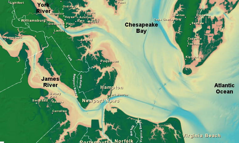
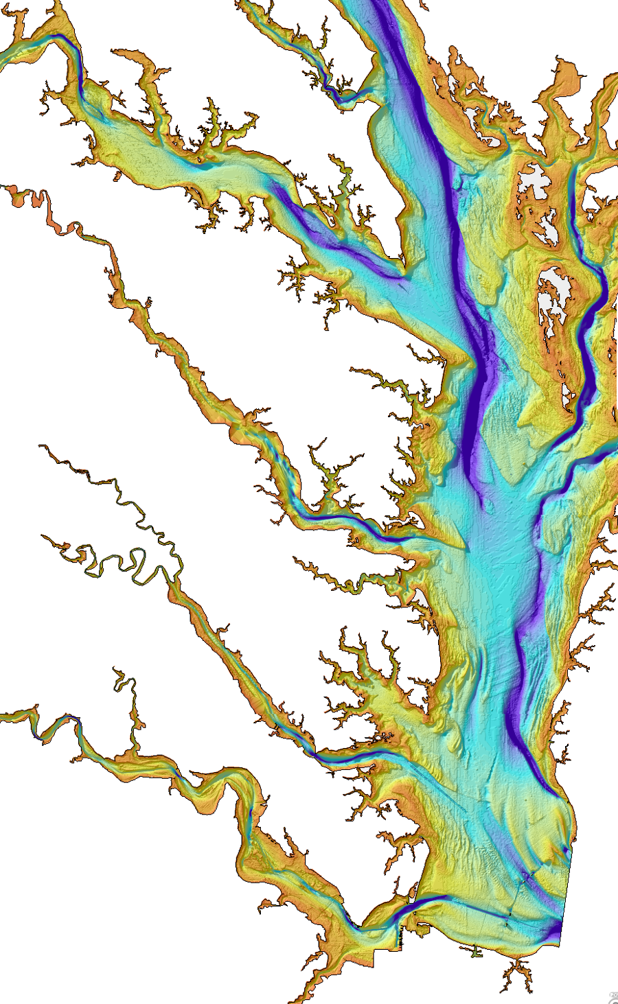
Chesapeake Bay bathymetry
Source: National Oceanic and Atmospheric Administration (NOAA) National Geophysical Data Center
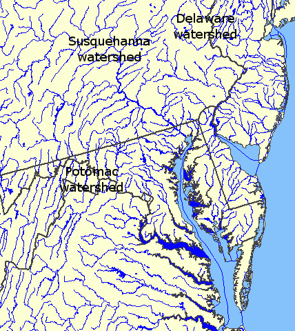
The Chesapeake Bay fills the drowned valleys of the Susquehanna and James rivers, plus tributaries that intersected the Susquehanna. The current shape of the bay is less that 10,000 years old - so Native Americans arrived in in Virginia in time to witness the conversion of multiple freshwater river channels into the brackish estuary of the modern Chesapeake Bay.
Chesapeake Bay bathymetry
Source: National Oceanic and Atmospheric Administration (NOAA) National Geophysical Data Center
The bay is a feature on the Coastal Plain. The Coastal Plain east of I-95 was created over the last 150-200 million years by erosion from the Appalachian Mountains and by deposition of sediments at the bottom of the Atlantic Ocean.
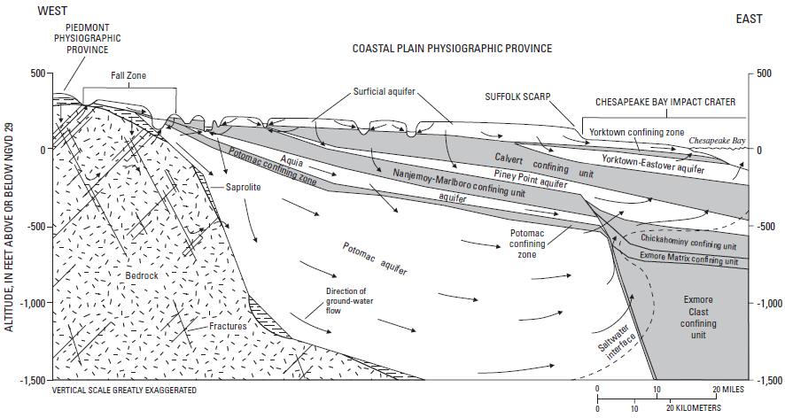
aquifers underneath Coastal Plain
Source: US Geological Survey, The Virginia Coastal Plain Hydrogeologic Framework (USGS Professional Paper 1731, Figure 2)
Various ridges, valleys, lakes, and rivers have formed and disappeared over that time; topography and hydrography have not been static. The sediments on the Coastal Plain include sharks teeth and whale fossils, documenting the different times when sea levels were higher and the Virginia shoreline located further west.
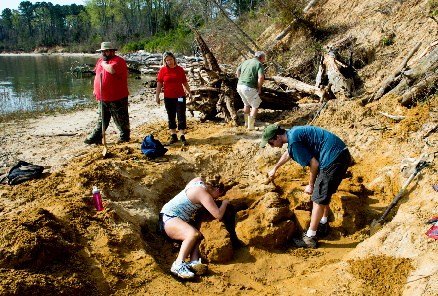
a 7-9 million-year-old whale skeleton was excavated at Naval Weapons Station Yorktown in 2013
Source: US Navy (130409-N-XJ695-007)
For at least several million years, the rivers we currently call the Susquehanna and Delaware have flowed from the uplands of New York and Pennsylvania to the Atlantic Ocean. For the last five million years, the Potomac River has eroded the remains of the Appalachian Mountains and carried them east through the gap at what is now called Harpers Ferry.
The specific paths of those rivers have varied as they have leveled the landscape. The rivers carved new channels across the Piedmont and Coastal Plain, cutting down through soft sediments and hard bedrock, as they carried dissolved/suspended particles downstream to be deposited on the ocean floor.

deposition from the north in Pliocene Epoch, prior to southern extension of Delmarva Peninsula in last 500,000 years
Source: US Geological Survey, Professional Paper 1067-A: Upper Cenozoic Deposits of the Central Delmarva Peninsula, Maryland and Delaware (Figure 2)
The rivers flowed down to the low spots on the edge of the continent formed by the Salisbury Embayment and Baltimore Canyon Trough. The mouths of each river have migrated in discrete "jumps," shifting to new channels after sea levels rose/fell during glacial periods in the last 2 million years. When sea levels rose, sand and gravel was deposited at the mouth of the rivers, blocking the old channel. Deltas, with barrier islands and spits, formed at river mouths during the periods of high sea level ("highstands").
Over geologic time since the oceans formed, sea levels have changed only about 1,000 feet. Subducting tectonic plates carry water down into the mantle, but that water does not stay trapped and gradually dry up the oceans. The water migrates back to the surface, primarily through volcanic eruptions.
Three major glaciations in the last 500,000 years caused sea levels to vary by as much as 500 feet. When sea levels dropped, an ancestor of today's river carved a new channel nearby, seeking the easiest path to the ocean - but bypassing the old river mouth, now blocked by accumulated sediments. The paleochannels, various scarps and terraces on the Coastal Plain, and canyons carved into the Continental Slope/Continental Rise, document the different stages of dropping sea levels.1
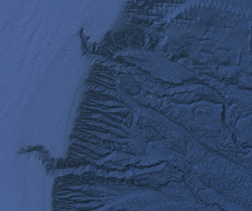
river canyons on Continental Slope, submerged about 15,000 years ago
Source: National Oceanographic and Atmospheric Administration (NOAA), Estuarine Bathymetric Data
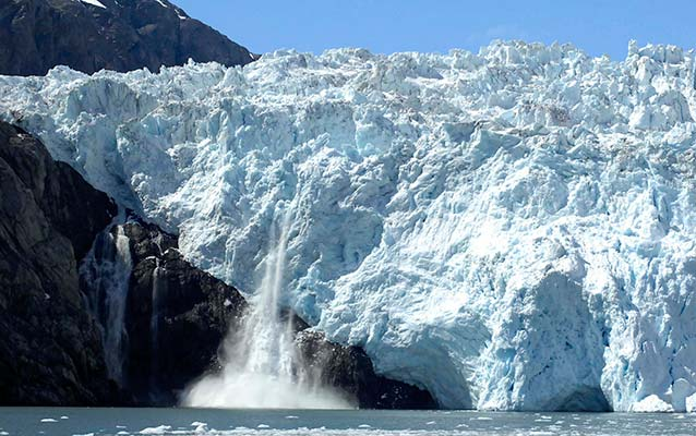
the Chesapeake Bay is a series of river valleys flooded by rising sea levels - not a fjord created by a glacier
Source: National Park Service, Those Fabulous Fjords!
The transformation of the Chesapeake Bay by changes in sea level is not unique. About 5 million years ago, sea level dropped over 2,000 feet. Major salt deposits accumulated at the bottom of a drying-out Mediterranean Sea before the connection with the Atlantic Ocean increased.
The shape of the modern Chesapeake Bay was formed through a combination of both erosion by the Susquehanna River and deposition by ocean currents. The trigger for shifting sands and river channels was the rise and fall of the Atlantic Ocean during various ice ages; water levels were as much as 300-400 feet higher or lower than today.
Over the last 500,000 years, the Delmarva peninsula has grown towards the south, fed by sediments eroded off the Appalachian Mountains in Pennsylvania/New York and carried by ocean currents. The channel of the Susquehanna River has been pushed south, past the former deltas of the Potomac/Rappahannock/York rivers and down to the channel of the James River.
Sediments were deposited during periods of high sea level and extended the ancient Delmarva "spit," while erosion of new Susquehanna River channels occurred during periods of low sea level. Old channels of the Susquehanna River can be identified underneath the current Eastern Shore, and on the edge of the continental shelf where "fossil" canyons such as the Washington Canyon show the former route of the river.
When the Susquehanna River carved new channels during low sea levels, the river migrated to the west of the old riverbed and the mouth of the river moved further south as the Delmarva Peninsula grew. Former channels of Susquehanna River were filled with sediment during "high stands" when sea levels were higher, and the river carved a new channel when sea level dropped to bypass the clogged channel.
Roughly 300,000 years ago, during a warm period when ice sheets had melted, the valley of what is now called the Susquehanna River was drowned by the high sea level. A precursor to the Chesapeake Bay formed, but the mouth of that earlier bay was 40 miles north of Cape Charles/Cape Henry. Then, after new ice sheets formed, that bay drained. The river flowed again, depositing sediments at its mouth and extending the Delmarva Peninsula further south.
About 150,000 years ago, after another cycle of changing climate and sea levels, the river valley was drowned again. Another bay formed, with its mouth 20 miles further south. The southern end of today's Delmarva Peninsula, ending at Cape Charles, was deposited when sea levels dropped again and sediments accumulated. The growth of the peninsula ended when the most recent Ice Age ended 18,000 years ago. Since then, the climate has warmed, sea levels have risen, the Susquehanna River valley has been drowned again, and the modern Chesapeake Bay has formed.
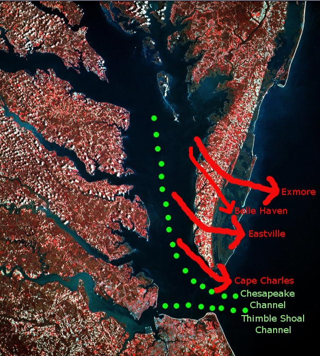
former channels of Susquehanna River were obliterated, as growth of Eastern Shore extended length of Chesapeake Bay (green dots show current Susquehanna River and James River channels)
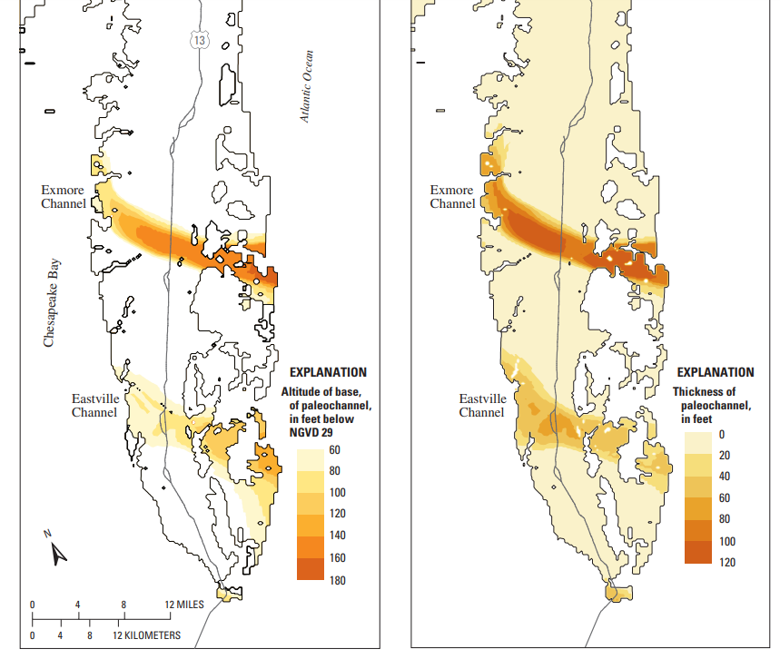
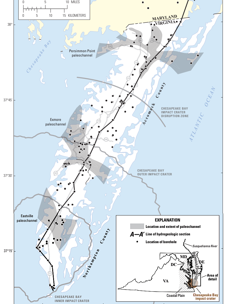
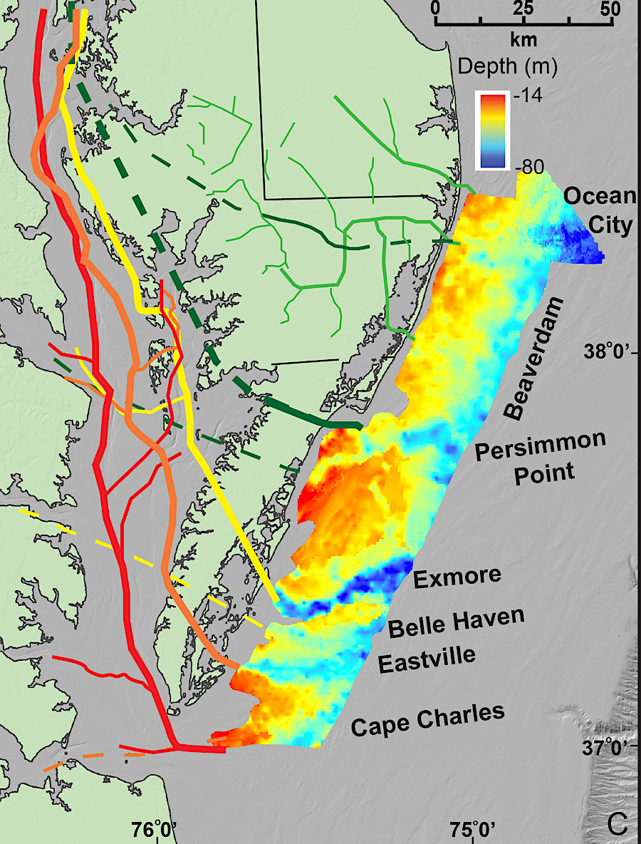
more-detailed maps showing the location of paleochannels across the Eastern Shore
Source: US Geological Survey (USGS), Simulation of Groundwater-Level and Salinity Changes
in the Eastern Shore, Virginia (Figure 6) and Hydrogeologic Framework of the Virginia Eastern Shore (Scientific Investigations Report 2019-5093, Plate 1); Marine Geology, Seismic stratigraphic framework of the continental shelf offshore Delmarva, U.S.A.: Implications for Mid-Atlantic Bight Evolution since the Pliocene (Figure 9)
A similar pattern is visible today at the mouth of the Mississippi River. The "birdsfoot delta" has been growing and the path of the river has been shifting, bypassing the deposits, for the last 7,000 years.2
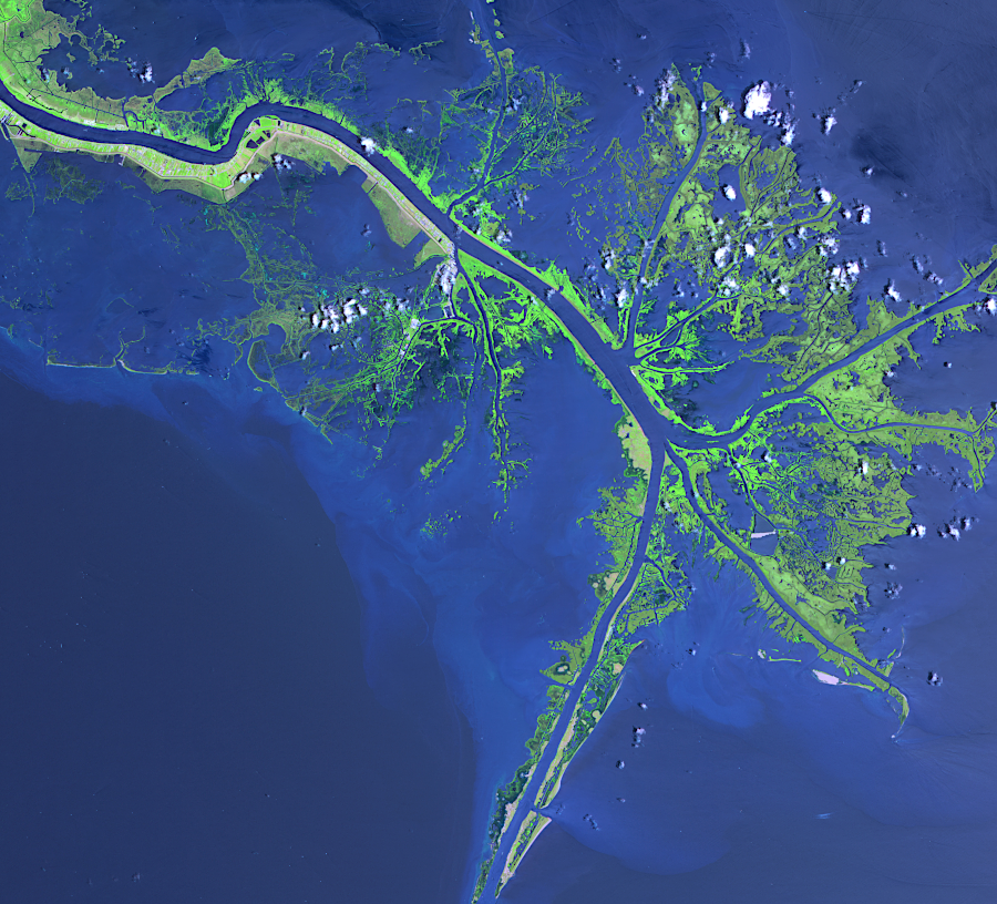
the shifting channels of the Susquehanna River are mimicked today at the mouth of the Mississippi River
Source: National Aeronautics and Space Administration (NASA), Mississippi River Delta
The Exmore Channel, the oldest paleochannel dating back to 300,000-500,000 years ago, was the path of the combined Susquehanna and Potomac rivers east across the Continental Shelf.
After sea level rose and covered the Continental Shelf, an estuary formed at the ancient mouth of the Susquehanna River. In the low-energy estuary, without strong river currents to flush away the sediments, the Exmore Channel filled up. Rising sea levels also triggered longshore currents that brought sediments from the north. The Accomack Spit grew southward, forming the northern portion of today's Delmarva Peninsula.
When sea level dropped again roughly 150,000 years ago as the ice sheets grew again, the Exmore Channel was filled with sediment and the old path was blocked by the Accomack Spit. The Susquehanna River did not return to its old path or carve a gap through the Accomack Spit. Instead, the river cut a new channel in softer sediments on the west side of the estuary, creating the Belle Haven channel. South of the barrier of the Accomack Spit and the old Exmore Channel, the mouth of the Belle Haven channel reached the Atlantic Ocean at roughly the latitude of today's Rappahannock River.
When sea levels rose again as ice sheets melted on the continents, an estuary developed at the mouth of the Belle Haven channel. At the same time, ocean currents deposited more sediments at the tip of the evolving Delmarva Peninsula, blocking the Belle Haven channel. When sea level dropped again, the Susquehanna River once again carved a new channel. Repeating the earlier pattern, the new Eastville Channel formed to the west of the old (Belle Haven) channel, with an outlet reaching the Atlantic Ocean further south.
Then again, sea levels rose and drowned the Continental Shelf and a portion of the Coastal Plain. Once again, another estuary formed at the mouth of the Susquehanna River as it flowed in the Eastville channel and that channel gradually filled with sediments. Along the oceanfront shoreline, longshore currents carried more sediments south from New York, New Jersey and Pennsylvania. The Nassawadox Spit grew, south of the Accomack Spit, and extended the Delmarva peninsula further south.
As summarized in a Chesapeake Quarterly article in 2011:3
The early Accomack spit, which blocked the Exmore channel, was deposited when sea levels were 12-15 meters above present level. The later Nassawadox spit, which blocked the Belle Haven and Eastville channels, was deposited when sea levels were 7.5-9 meters above present level. Ames Ridge on the Eastern Shore marks the boundary between the two.4
As the Laurentide ice sheet advanced to its maximum position, ocean levels dropped again with a rapid, final drop between 30-22,000 years ago.5
The Susquehanna River moved west one more time and etched the Cape Charles Channel - and once again bypassed the expanded Delmarva peninsula by migrating the river mouth further south.
When the last Wisconsin glaciation ended 18,000 years ago, sea levels rose one last time, drowning the mouth of the Cape Charles Channel and forming another estuary. Continued deposition by longshore currents extended the Delmarva Peninsula south and widened it out to Smith Island Shoals. Starting around 6,500 years ago, sediment transported from the shoals (and points north) buried the mouth of the Susquehanna River one last time, blocking the eastern end of the Cape Charles Channel. That forced the Susquehanna River over 5 miles to the south, to carve today's Chesapeake Channel to the Atlantic Ocean.
The mouth of the Chesapeake Bay is not migrating further, for the moment. The currents in the old Susquehanna and James river channels appear to be strong enough to block new sediment deposition, so the southern tip of the Eastern Shore is not growing to the south.6
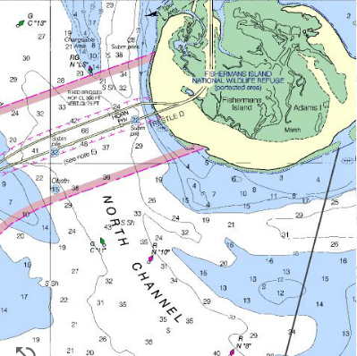
west of the entrance to the Chesapeake Bay, the North Channel is the former Cape Charles Channel, but the eastern portion has been buried by 160' of sediments (including Fisherman's Island)
Source: NOAA Nautical Chart On-Line Viewer Number 122208 - Approaches to Chesapeake Bay

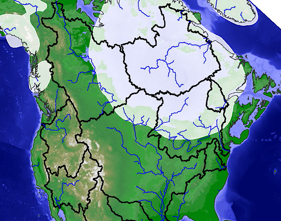
shape of North American when sea level was 110 meters below the present level 18,000 years ago
(there is no Chesapeake Bay, and the peninsula of Florida extends much further west)
Source: NOAA National Geophysical Data Center, Global Land One-km Base Elevation Project (GLOBE)
Virginia's eastern coastline did not move inland from the Continental Slope until about 12-15,000 years ago, when the ocean began to flood over the wide Coastal Plain of that time. Roughly 9-10,000 years ago, the rising Atlantic Ocean submerged the mouths of the James and Susquehanna rivers, and may have reached as far north as the Rappahannock River.7
Sea level rise tapered off about 6,000 years ago,8.
The bay took on its present shape about 3,000 years ago.9

eastern boundary of Virginia during last Ice Age
Source: USGS Circular 1262, Ground Water in Freshwater-Saltwater Environments of the Atlantic Coast
The creation of the bay may have occurred in stages, rather than in a steady process. Changing chemistry in sediment cores suggest one rapid expansion of the bay occurring roughly 8,200 years ago. The Chesapeake Bay expanded in a quick surge, after a lobe of the Laurentide ice sheet melted and glacial lakes Agassiz and Ojibway rapidly released a pulse of fresh water into the North Atlantic. When the lake water drained off the continent, that event increased the volume of the oceans, triggered both a quick rise in sea level, and altered ocean currents enough to create a brief cooler-than-normal climate.10
Another possibility: the Susquehanna River valley flooded slowly within its channel until sea water finally rose onto the floodplain, creating a sudden one-time increase in the size of the bay. In this scenario, the Susquehanna River floodplain flooded quickly because of its flat topography - rather than because a pulse of meltwater (from the ice sheet covering Canada) suddenly increased the volume of the oceans.11
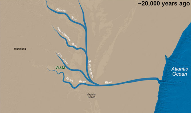
the Chesapeake Bay formed as sea level rose 300 feet and flooded the channels of the Susquehanna, James and other rivers
Source: Chuck Bailey, William and Mary, The Foundation of the College
When the ice sheet reached into Pennsylvania, New York, and Massachusetts, rocks and sand were deposited at the melting edge by the ancestral Hudson River, and even directly by the ice sheet. Terminal moraines still remain today as Cape Cod, Nantucket Island, Martha's Vineyard, and Long Island. South of the melting edge, the Delaware and Susquehanna rivers carried glacial debris to the edge of the Atlantic Ocean.
Sand from the northern coast has been pushed south by longshore currents. In the last 18,000 years (especially in the last 6,000), those sediments were shaped by waves and currents into the beaches/barrier islands along the East Coast shoreline, south to Cape Hatteras in North Carolina.
Sediments of the Eastern Shore were scraped up by the ice sheet and transported from as far away as Canada during the last Ice Age, before being deposited on the East Coast. At various times until about 11,000 years ago, water flowed from the drainage basins of the modern Great Lakes into the Susquehanna and Hudson rivers. Sand grains now at Chincoteague, on the bottom of the Chesapeake and Thimble channels, and at Virginia Beach could have come originally from Ontario and Quebec.
boundaries of drainage basins changed as the ice sheet melted, and sediments from as far away as Lake Superior washed to the Susquehanna and Hudson rivers
Source: Andrew D. Wickert, Reconstruction of North American Drainage Basins and River Discharge Since the Last Glacial Maximum (ANU model, 11,500 years ago)
The James River carved its own channel towards the edge of the Continental Shelf when sea levels were lower, and even today the Susquehanna and James flow in distinct paths. Their river channels parallel each other, at the mouth of the Chesapeake Bay between Cape Charles/Cape Henry.
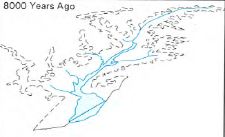
former shape of Susquehanna River valley, before sea level rise created Chesapeake Bay
Source: US Fish and Wildlife Service, Vanishing Lands - Sea Level, Society, and Chesapeake Bay (Figure 2)
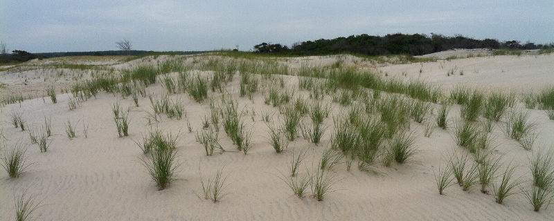
sand dune at Assateague Island, with quartz sand grains that may once have been on an Appalachian mountaintop
The two sets of tunnels for the Chesapeake Bay Bridge-Tunnel mark the Chesapeake Channel (on the north, in the Cape Charles Channel carved by the ancestral Susquehanna River), and the Thimble Shoal Channel (on the south, carved by the James River). Ships sailing to Baltimore use the Chesapeake Channel and follow the path of the drowned Susquehanna River north, while ships headed to Norfolk use the Thimble Shoal Channel and follow the drowned James River west. The pilings to hold up the bridge were located where the sand/mud was densest, so the bridge curves rather than runs in a straight line.12
Chesapeake and Thimble Shoal channels - drowned Susquehanna and James rivers at mouth of Chesapeake Bay
Source: National Oceanic and Atmospheric Administration (NOAA) Office of Coast Survey
The sea level of the Atlantic Ocean has been rising for roughly 18,000 years. When the ice sheets stretched to their greatest extent, the Atlantic was a much smaller ocean because so much water was still trapped in the ice. As the ice melted, fresh water surged into the oceans in various meltwater pulses, and flooded the valleys of the James River, Susquehanna River, and other tributaries to the Chesapeake Bay to create the present pattern of land and water - but that pattern will change.
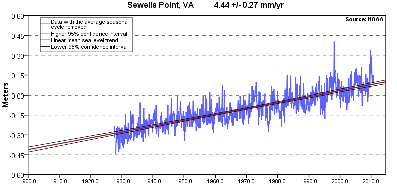
Sewells Point sea level rise from
1927-2006 (averaging 4.44 millimeters/year, equivalent to a change of 1.46 feet in 100 years"
Source: National Oceanic and Atmospheric Administration (NOAA), Sea Level Trends
Today, the Atlantic Ocean is roughly 350 feet (100-120 meters) higher than when glaciers reached into Pennsylvania, and sea level has been rising slowly at the rate of 6 inches/century.13
In November 2010, the Virginia Institute of Marine Science (VMS) calculated the trend of Absolute Sea Level rise for Virginia. Absolute Sea Level rise is measured relative to the center of a reference ellipsoid, in contrast to other studies that calculate relative sea level (RSL) by comparison with fixed points on the earth's surface. Using Absolute Sea Level separates changes in the ocean's height from changes in subsidence of land, both of which affect how Virginia's shoreline will change.
The 2010 VIMS study concluded that absolute sea level rise in the Chesapeake Bay between 1976-2007 is 1.8 mm/yr, less than the worldwide average of 3.1mm/year calculated by the Intergovernmental Panel on Climate Change (IPCC) Fourth Assessment Report in 2007. Subsidence ranged from -1.3 mm/yr to -4.0 mm/yr at different locations, causing over 50% of the change in relative sea level.
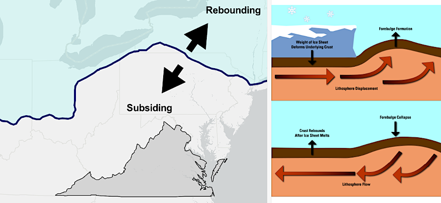
land once underneath the ice sheet is rebounding; land in front of it is subsiding
Source: US Geological Survey (USGS), Land Motion and Subsidence on the Virginia Coastal Plain
A study published in 2026 concluded that across the Chesapeae Bay, land was sinking by an average of 1.4 millimeters per year - the width of a penny. The fastest rate around Hampton Roads was slowing down, perhaps because groundwater withdrawal had been reduced. The rate of ground subsidence at Mexico City and Shanghai was reduced by injecting fluids underground, increasing the pressure at depth. The Sustainable Water Initiative for Tomorrow (SWIFT) Project in Hampton Roads to inject treated wastewater into the Potomac Aquifer could have the same effect.
In 2025, the Hampton Roads Planning District Commission proposed that local jurisdictions update building codes, land use plans, and highway/bridge construction designs that assumed the rate of sea level rise would be the average increase between 1980-2000. Instead, localities should assume:
- 1.5 feet of relative sea level rise by 2050
- 3 feet of relative sea level rise by 2080
- 4.5 feet of relative sea level rise by 2100
A 2023 study revealed that land in Hampton Roads is sinking twice as fast (6 millimeters per year) as sea levels are rising (3.3 millimeters/year). A 2020 study revealed that subsidence varies significantly within very close distances. Nearby neighborhoods are sinking at rates which vary as much as 15-20%, based on data from Interferometric Synthetic Aperture Radar (InSAR). Those planning future flood control measures can not rely upon average regional rates of sea level rise.
One scientist assessed the problem of subsidence vs. sea level rise:14
Land subsidence is significant enough to suggest that existing coastal communities are at risk of future flooding, no matter how local or state officials may feel about global warming. Even ancient archaeological sites will be affected. A 2012 study concluded that:15
higher levels of salt water have killed trees and created "ghost forests" on Goodwin Islands at the mouth of the York River
Source: Virginia Institute of Marine Sciences (VIMS), Coastal Geomorphology Lab - Goodwin Islands
The rate of sea level rise determines in part if an archaeological site will be drowned quickly and preserved, or eroded by wave action. Few, if any, are expected to survive. The same study noted:16
If sea level rise predictions of the Intergovernmental Panel on Climate Change come true, the Chesapeake Bay could disappear completely and become a salt water gulf comparable to the Gulf of Maine, after the Eastern Shore is covered completely by a rising Atlantic Ocean.17
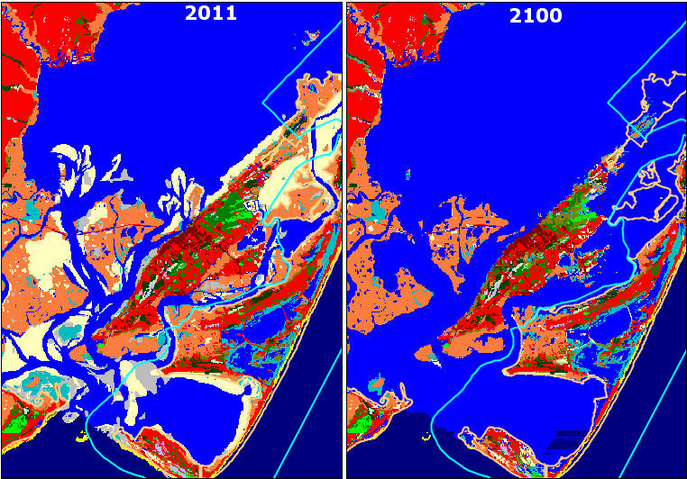
Potential impact of sea level rise at Norfolk/Virginia Beach
Source: Environmental Protection Agency (EPA), Maps of Lands Vulnerable to Sea Level Rise -- On the Mid-Atlantic Coast
projected impact at Chincoteague of sea level rising 0.7meters (2.3 feet) by 2100
Source: Sea Level Affecting Marshes Model (SLAMM)
Features along the Chesapeake Bay can be altered by "singular" events as well as by long-term changes in sea level. A meteorite or comet ("bolide") impacted 35 million years ago in what was then the Atlantic Ocean, but is now Cape Charles on the Eastern Shore. The crater still shapes the aquifers that supply groundwater, and may have caused subsidence that shaped the path of the James and Susquehanna rivers once the Susquehanna River deposited most of what is now the Eastern Shore.
An October 1749 hurricane thrust sand from the bottom of the Chesapeake Bay onto the southern shoreline. A second storm, the Great Coastal Hurricane of 1806, enlarged what is today Willoughby Spit. A future storm has the potential to dramatically erode the sediments there, causing great destruction to a recent geological feature on which people have built houses.18
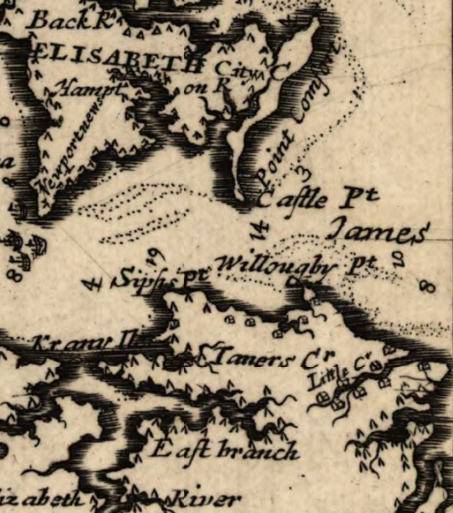
Willoughby was a primarily an underwater shoal, not a spit, in 1670
Source: Library of Congress, Virginia and Maryland as it is planted and inhabited this present year 1670 (by Augustine Herrman)
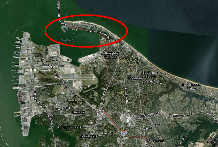
Willoughby Spit today
Source: ESRI, GIS Online
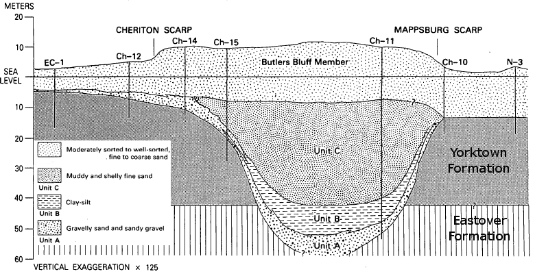
sediments filling Eastville Channel paleovalley
Source: Upper Cenozoic Deposits of the Central Delmarva Peninsula, Maryland and Delaware (Figure 18)
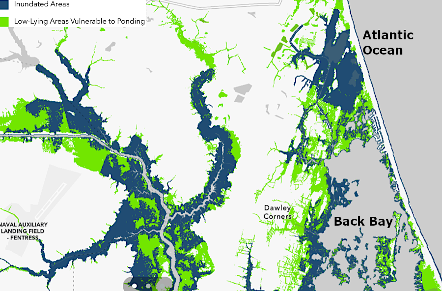
land adjacent to Back Bay and the North Landing River in the City of Virginia Beach will be flooded by 1.5 feet of sea level rise
Source: US Geological Survey (USGS), Land Motion and Subsidence on the Virginia Coastal Plain
major rivers providing sediment to form Delmarva Peninsula
Source: US Geological Survey, National Atlas
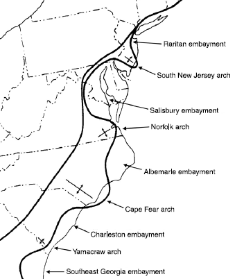
major embayments on eastern side of North America
Source: US Geological Survey, Geology of the National Capital Region - Field Trip Guidebook, Tertiary Lithology and Paleontology, Chesapeake Bay Region
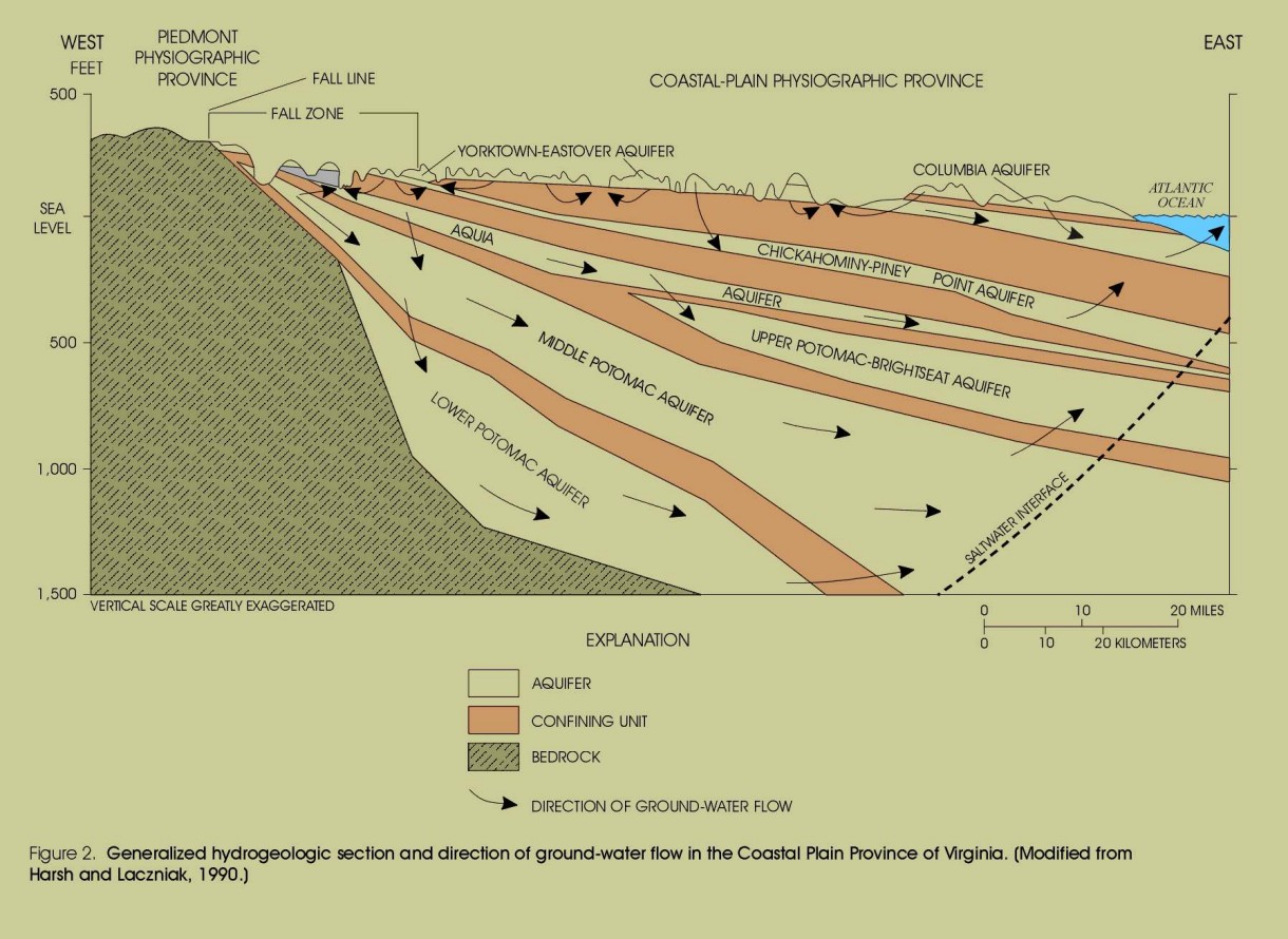
aquifers in sediments between surface of Coastal Plain and basement bedrock
Source: US Geological Survey, Design, Revisions, and Considerations for Continued Use of a Ground-Water-Flow Model of the Coastal Plain Aquifer System in Virginia, Water Resources Investigations Report 98-4085
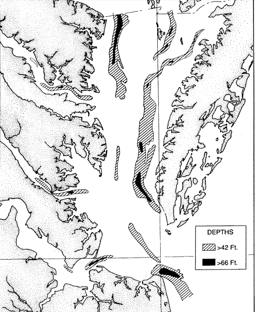
depths in the Chesapeake Bay reflect erosion by rivers, prior to sea level rise that has drowned the old river channels
Source: House Document No. 16, Beneficial Uses of Dredged Materials in Hampton Roads, Virginia (1993)
bathymetry of the Chesapeake Bay
Source: ESRI, ArcGIS Online (with National Ocean Service layer, "Bathymetric Data for Select U.S. Estuaries")