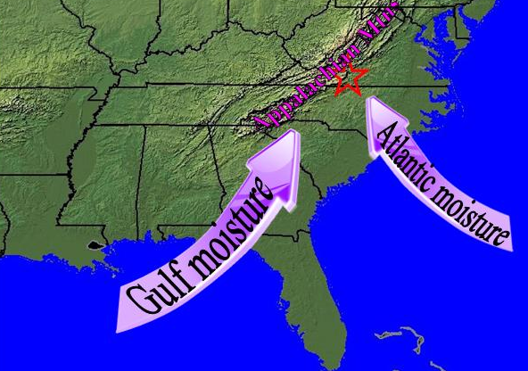
moisture sources for frontal cyclones (hurricanes, tropical storms, and nor'easters) in Virginia
Source: National Weather Service, The Heavy Rainfall Patterns of Winter
moisture sources for frontal cyclones (hurricanes, tropical storms, and nor'easters) in Virginia
Source: National Weather Service, The Heavy Rainfall Patterns of Winter
Almost every weather report will highlight if rain is predicted. There are two primary types of storms that generate rain in Virginia. Big storms (frontal cyclones) sweep in from the Atlantic Ocean and affect primarily the eastern edge of the state, while localized summer thunderstorms provide most of the rain in the mountains.
A few frontal cyclones, such as Hurricane Camille in 1969, can migrate all the way north from the Gulf of Mexico before drenching Virginia. Such storms can drop one to two feet of rainfall in a day, generating massive floods and stripping the soil off the Blue Ridge in dramatic landslides. Thunderstorms are routine in the summer when differential heating of land and water is more intense, but the rare frontal cyclones can cause more erosion and more damage to roads/houses in just 24 hours than several centuries of routine thunderstorms.
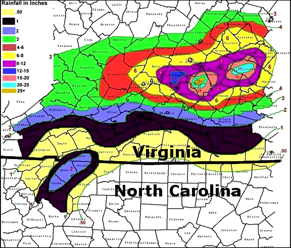
Hurricane Camille stalled over Nelson County and dropped nearly 30 inches in rain in one evening
Source: National Weather Service, Camille Turns 40
As described in a Virginia State Climatologist report, the major storms such as hurricanes are more important in recharging groundwater, providing rain to put out fires in Great Dismal Swamp, and raising water levels in drinking water reservoirs east of the Blue Ridge:1

Hurricane Floyd's rainfall pattern in Northern Virginia
Source: US Geological Survey (USGS), Hurricane Floyd Information - Rainfall Totals (NOAA map)

Hurricane Floyd's rainfall pattern in Southeast
Source: US Geological Survey (USGS), Hurricane Floyd Information - Rainfall Totals (NOAA map)
Storms are triggered by differential heating. Air is heated at the Equator, then rises up and moves north towards the cooler poles. High in the troposphere, warm air cools and descends in latitudes around 30° North, forming a "Hadley Cell." The Coriolis effect steers the descending air to the right, so wind currents (including the jet stream) bring storms from the west into Virginia.2
A "west wind" is a wind that blows from the west. The weather experienced yesterday in Missouri and Ohio will often be Virginia's weather today.In the winter, polar air masses from Canada are pushed south and then towards the east by the jet stream. Storms on the West Coast require several days to move across North America. An artic air mass in 1899 ran into moist air from the Atlantic Ocean resulting in 13" of snow falling on Norfolk between February 11-13. The "Great Blizzard" in Hampton Roads is also remembered as the "St. Valentine's Day Blizzard."
A January 24, 2026 snowstorm was followed by two weeks of freezing weather. Plows struggled to move the ice and "snowcrete" from the roads; 40% of the equiment in Henrico County was damaged by the unusually hard ice.
Citizens complained to elected officials, but a Henrico County supervisors put the challenge into context. It had been almost 30 years since a similar storm, and he did not consider it to be a smart investment to purchase and stockpile enough equipment to deal with such a rare event:3
In the summer, when the jet stream moves north and the low pressure systems from the Gulf of Mexico travel northeast, forecasters in Virginia also pay close attention to the weather in Arkansas and Tennessee. Air heated by the warm water in the Gulf of Mexico can move north from New Orleans to Richmond in just a day.
When low pressure systems cause winds to blow in a clockwise direction across the Gulf Stream, easterly winds can move warm and moist air from the Atlantic Ocean into the Eastern Shore and Hampton Roads.
A long day of sunlight will heat the ground, and that heat is radiated into the atmosphere where it can create local thunderstorms. There are on average 40,000 thunderstorms each day worldwide, or nearly 15 million per year.
The same local heating west of the Blue Ridge and in northwestern Virginia, far from the Chesapeake Bay and the Atlantic Ocean and the wider sections of the rivers, may not have enough moisture in the air to generate the same number of thunderstorms.
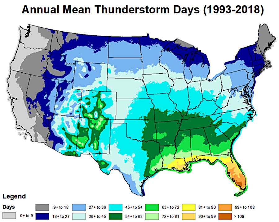
most places in Virginia experience about 40 thunderstorms each year
Source: National Oceanic and Atmospheric Administration (NOAA), Thunderstorms
Across the state, a "pulse" storm is always possible. Strong updrafts can create cauliflower-shaped cumulus clouds, showing water vapor becoming droplets. The condensation releases heat, while creating instability between rising air and the heavier air with droplets. In the process, currents of air with different electrical charges trigger lightning and thunder. The discharge may occur even where condensation is not visible, creating a "bolt out of the blue" lightning strike.
If there are just light winds aloft that do not disperse the condensing droplets, the heavier air becomes a downdraft that "pulses" to the ground and disperses with gusts of wind. A single cell or "pulse" thunderstorm consists of a one-time updraft and one-time downdraft. If winds aloft disperse the heavier air, multiple cells can form and bands of rain can fall in different bursts.

unlike a pulse thunderstorm, supercells with multiple updrafts and downdrafts generate higher wind speeds and more-intense rain
Source: National Weather Service, Types of Thunderstorms
Intense microbursts can generate winds strong enough to threaten aircraft.
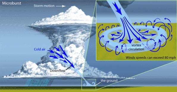
updrafts and downdrafts create cells in which moisture condenses, and intense downdrafts can threaten aircraft
Source: National Weather Service, What is a Microburst?
In a "supercell" storm, winds turn clockwise as the warm and humid air rises. A large, flat updraft base is visible, and the entire cloud rotates. High precipitation almost surrounds the updrafts. Updrafts and downdrafts can produce winds moving as fast as within a hurricane.4
If droplets are uplifted multiple times to an altitude where the air is cold enough, repetitive freezing can create hail. Both "dry" and "wet" hailstones form in updrafts. In the "wet" process," a hailstone is uplifted through a zone of air that is just below freezing when it encounters a supercooled droplet. The still-liquid water in that supercooled droplet will have enough time to spread across the hailstone, allowing air bubbles time to escape before the water freezes into a new layer of clear ice surrounding the hailstone.
In the "dry" process, the hailstone passes through colder air when it collides with a supercooled (and still liquid) droplet. The droplet freezes quickly. Because air bubbles dissolved in the supercooled droplet do not have time to escape, the rim of ice created around the hailstone is cloudy/opaque.
The largest hailstones recorded in Virginia fell in different 1968 storms in Loudoun and Lee County. Those hailstones were five inches in diameter. The largest in the United states was an eight inch hailstone that landed in Vivian, South Dakota in 2010. It weighed 1.94 pounds, the heaviest ever recorded in the Western Hemisphere.5
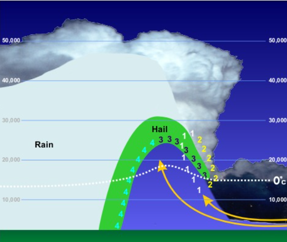
the stronger the updraft and the more times hail collides with supercooled droplets, the larger the hailstones
Source: National Weather Service, Thunderstorm Hazards - Hail
Supercells with continuous, well-organized, rotating updrafts can generate 'wall clouds'" and spawn tornadoes. If an air mass with supercell storm conditions moves in a straight line, it can create a "derecho" rather than a classic thunderstorm:6
Rainstorms in the winter may last up to three days, while summertime storms are typically over in just one day. Summertime vacationers at Virginia Beach enjoy clear skies and warm weather due to the Bermuda High, a high-pressure system in the North Atlantic that creates stable weather along the coast for much of the summer.
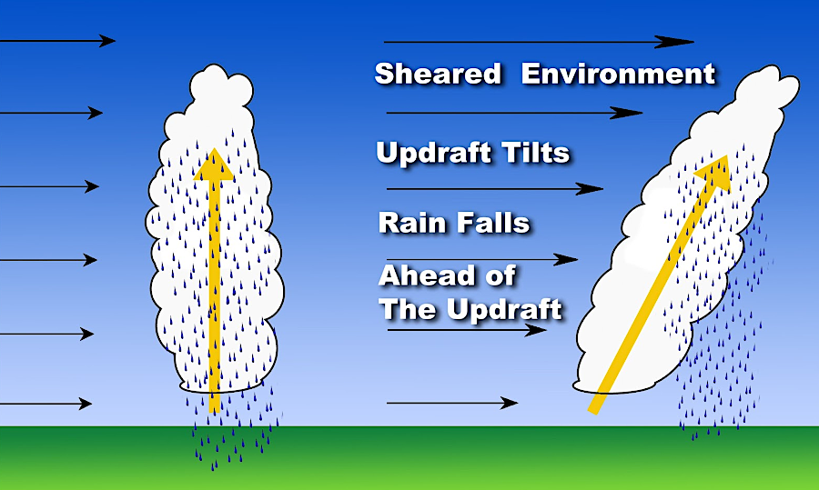
wind shear at higher altitude can cause rain to fall in front of a updraft
Source: National Weather Service, Severe Weather Topics - Week 2: What is Wind Shear?
A northeaster is a storm where the wind comes from the northeast. Wintertime nor 'easters, when the wind and the currents at Virginia Beach push the sand in the same direction with great energy, can cause great erosion of the Atlantic and Chesapeake shorelines. One or more strong storms can undo the efforts of the Big Beach project, which widened the Atlantic Ocean beach at Virginia Beach about 300 feet to provide more recreational space in front of the hotel strip along Atlantic Avenue.
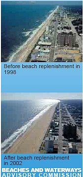
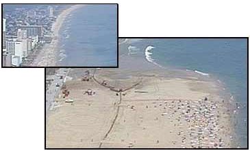
beach replenishment
Source: Virginia Beach Public Works Department, Beach Management Plan
Hurricanes, typically in August-November, threaten lives as well as property and get much more attention that nor 'easters. They also have very obvious impacts, both short term and long term. Storm surges between 1799-1806 pushed enough sand onshore to build Willoughby Spit, now the southern terminus in Norfolk of the Hampton Roads Bridge-Tunnel on I-64.7
The threat of a storm surge creates great concern in the Hampton Roads area. Between Hampton and Williamsburg, Interstate 64 has special sections of the median already paved and painted for reversing traffic on the eastbound lanes. That would double the capacity of the highway for evacuating the Hampton Roads area - if people are willing to leave as soon as warning are issued.
As the climate gets warmer, there is more energy in heated ocean water and air currents. Storm intensity is increasing, as that heat is redistributed in the atmosphere. Insurance companies are responding by raising rates as damaging storms generate more claims.
Insurance rates are also increasing due to land use patterns. New development in rural areas and increasing suburban sprawl is creating more structures that can be damaged by tornadoes and other storms that used to impact just fields and forests. The National Oceanic and Atmospheric Administration (NOAA) list of billion-dollar weather disasters and million-dollar storms has been steadily increasing in the 21st Century.
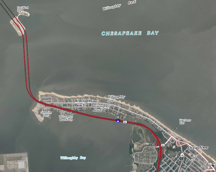
Willoughby Spit - created by storms (think it is a safe place to build a house?)
Source: US Geological Survey, Norfolk North 7.5x7.5 topographic quad (2011)
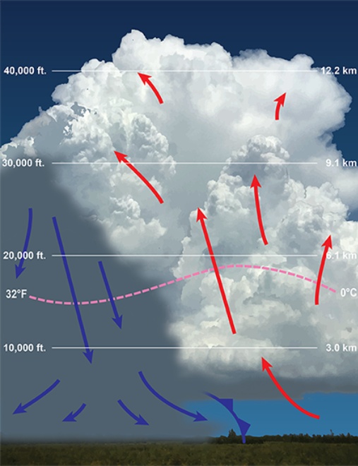
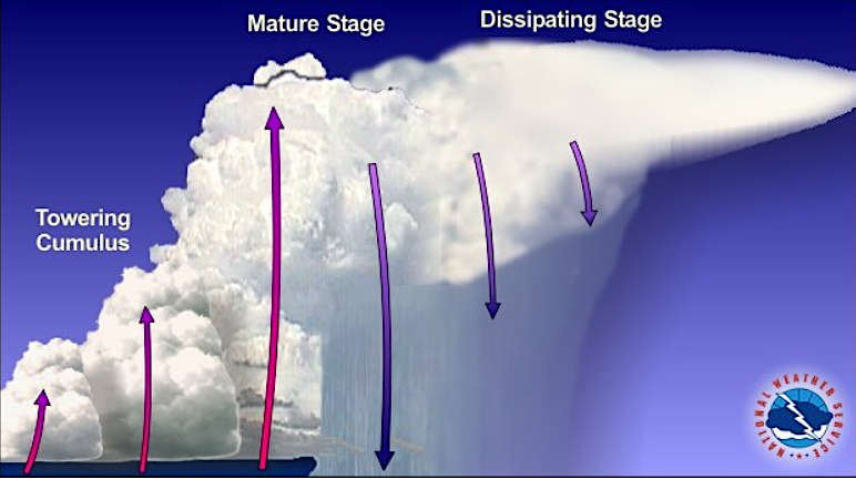
cumulus clouds can reach so high that aircraft must fly through them, rather than above them
Source: National Oceanic and Atmospheric Administration (NOAA), Life Cycle of a Thunderstorm