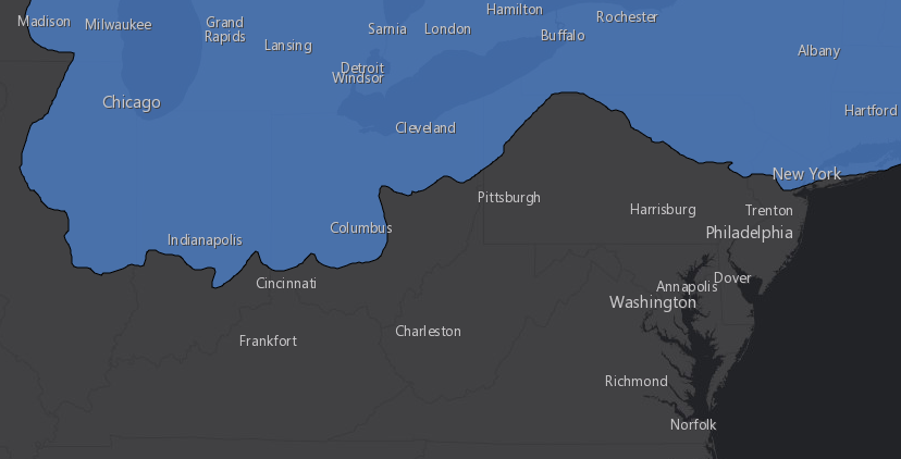
the ice sheet stopped in Pennsylvania 18,000 years ago at the peak of the Wisconsin glaciation
Source: ESRI, ArcGIS Online
the ice sheet stopped in Pennsylvania 18,000 years ago at the peak of the Wisconsin glaciation
Source: ESRI, ArcGIS Online
The earth has experienced five major time periods where a higher percentage of the surface was covered with ice. In the Huronian Ice Age 2.4-2.1 billion years ago and again in the Cryogenian Ice Age between about 850 and 630 million years ago, ice may have reached the Equator to create a "Snowball Earth." Scientists continue to explore whether an ice-free band of open water remained at the Equator which allowed the survival of complex marine life, perhaps in a "Slushball Earth."
The Andean-Saharan Ice Age was 460-420 million years ago, and the Karoo Ice Age was 360-260 million years ago. We are currently experiencing the fifth ice age. The Quaternary Ice Age began at the start of the Pliocene Epoch 2.6 million years ago. The current ice age has involved cycles of advancing and retreating ice sheets.
In the last million years, major ice sheets have grown southward across North America and then retreated eight times. The production of the last ice sheet, the Wisconsin stage, started about 75,000 years ago and reached is maximum extent about 20,000 years ago. For the last 10,000 years, we have been in a warm interglacial time labelled on the Marine Isotope Stage (MIS) timescale as MIS-1. The Wisconsin glaciation is MIS-2.
The Quaternary Ice Age could have been triggered by the closing of the Panama Seaway and alterations in the salinity in different parts of the oceans, changes in the earth's orbit, large-scale changes in ocean currents and the East Asian Monsoon, and/or lower carbon dioxide levels in the atmosphere caused by the weathering of the Himalayas and the sequestering or carbon in ocean sediments.
About 20,000 years ago, global temperatures averaged 46°F (8°C). In 2020, the average worldwide was 58.8°F (14.9°C).
Ice covered 25% of the land area at the greatest extent of the Wisconsin stage. That continental ice sheet has been retreating for the last 18,000 years, and today ice covers just 11% of the land area.
The last ice age may have ended in part with the release of carbon dioxide (CO2) into the atmosphere from a "salty blob" of seawater that had been trapped deep in the ocean. The cold, salty, dense water came to the surface off the coast of Western Australia 18,000 years ago in a relatively rapid ocean upwelling event. The additional CO2 stimulated global warming.1
The Laurentide Ice Sheet grew during the Wisconsin stage. It stopped north of the Ohio River and the Pennsylvania Turnpike, and at modern New York City. During the furthest extent of the ice that ended 18,000 years ago, Virginia was never buried underneath a thick layer of ice.

18,000 years ago, a glacial ice sheet stretched south into what is now Pennsylvania
Source: Dr. Ron Blakey, Paleogeography and Geologic History of North America
There may have been a small mountaintop glacier on Mount Rogers, the highest peak in Virginia at 5,729 feet, but no evidence of glaciation remains. Peaks in Virginia may have been covered with snow during the winter, but wind and sun removed the snow before it was compressed to form glaciers.
Mount Mitchell in North Carolina is 6,684 feet high, and in the 1970's there was a claim of glacial scratches on the bedrock of that peak. However, later investigation revealed that cables used in logging operations had carved the grooves.2
Virginia still experienced significant impacts from the cold climate in the last Ice Age. The Laurentide Ice Sheet altered the location of the Atlantic Ocean shoreline. About 125,000 years ago, sea level was about 15' higher than today. Sea level dropped 400' as water was trapped in the ice sheet. The Continental Shelf was exposed, and the shoreline was 40-75 miles east of modern Virginia Beach.
The winds, rains, and temperature of Virginia's paleoclimate were affected significantly by the presence of the Laurentide Ice Sheet. Cold dry winds blasted south, bring only 25" of moisture annually compared to over 40" today. Sand was blown into dunes by stronger winds that those we see today.
"Thermokarst" lakes formed on the Coastal Plain when water in sandy soil melted in summer. Winds blowing from the northwest off the ice sheet stirred currents within shallow lakes. Between the wind and moving water, sandy sediments were pushed into ridges that formed an elliptical pattern. European colonists called the geomorphic features "Carolina bays" due to their abundant bay trees.
The first stage of Lake Drummond in today's Great Dismal Swamp probably started as a Carolina bay. The pocosins of today in the Hampton Roads area, the wetland bogs with woody shrubs growing on sandy peat soil, owe their origin to an ice sheet far away in Pennsylvania.
Paleo-Indians sheltered on the sandy hills along the Nottoway River at Cactus Hill and Blueberry Hill to avoid the winds. The earliest humans in Virginia preferred north-facing slopes even though the sun was warmer on south-facing slopes, because the winds swept away the biting insects in the river valley. The options for where to stay on hunting and gathering trips increased as the climate warmed, except during the Younger Dryas.
In the Younger Dryas period 14,500-11,500 years ago, temperatures dropped again to near-glacial conditions. Ocean currents bringing warm water from the tropics along the Atlantic Ocean coastline may have been disrupted by the shift of cold meltwater that had been flowing from the edge of the ice sheet down the Mississippi River. Melting of the ice may have opened up a path through the St. Lawrence River valley, blocking the currents that were bringing warmth to Virginia.3
The ice was 2,000' thick on top of modern Manhattan Island, taller than the Freedom Tower. The edge of the ice sheet stayed at the same location long enough for meltwater to deposit a massive amount of debris scraped up by the glacier, forming Long Island. As the ice sheet melted and then retreated, much of that glacial sand was swept down the Hudson and Susquehanna rivers to form the Eastern Shore.4
The weight on the ice sheet pressed down on the bedrock, depressing the land into southern Pennsylvania. Manhattan was pressed down at least 150 feet by the weight of an ice sheet that was taller than any skyscraper ever built on that island.
The land further south flexed differently in response to the pressure. Beyond the edge of the ice sheet, bedrock bent upwards. As a result, at the peak of the Ice Age the land along Virginia's coastline was raised up while land at the edge of the ice sheet was pushed down.
Sea level was already as much as 400 meters lower because so much water was trapped in the glaciers, and the eastern coastline of Virginia was as much as 40 miles east of the current location. The flexing earth raised the Virginia coastline even higher and extended the Coastal Plain even further to the east.
Today, the ice sheet has retreated far north. The depressed bedrock in Pennsylvania is rebounding upwards. The area along the current Atlantic Ocean shoreline, the crust that was uplifted in response to the nearby ice, is sinking back down now. That isostatic adjustment, combined with global warming, is causing faster-than-average sea level rise along Virginia's Atlantic Ocean shoreline and in the Chesapeake Bay.5
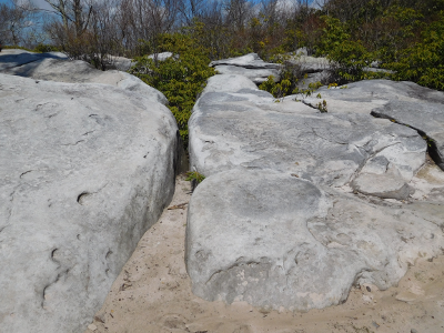
In the Valley and Ridge province, blocks of stone cracked loose from the bedrock on the sandstone ridges, slid downhill, and created piles of boulders in a talus slope below the quartzite bedrock. Relic landslides in the Blue Ridge and throughout the Valley and Ridge province may date back to a pattern of freezing and thawing which we do not see in the modern climate.
When the climate warmed, the hillsides stabilized and the forests returned. Trees grew below the talus pile and above their eroding bedrock source, but not on the barren boulders themselves.
The freezing and thawing cycle os less intense now. Few new rocks were added to the talus in the last 10,000 or so years. The pile of talus rock has moved downhill under the force of gravity since the Ice Age, but new talus is no longer added regularly on the uphill edge of the talus pile.
Over centuries, gaps have developed between the source bedrock and the talus piles, and trees have grown in those gaps. The isolated block fields - below the trees and now separated from the layer of sandstone that eroded to form the original talus pile - stand out against the forested mountainsides today. Those isolated block fields are remnants of the Ice Age climate.6
"Block fields" are still clearly visible on the western slope of Massanutten Mountain. During the last glacial period, cold winds blew across the mountains and little vegetation could grow there. Cracks in the sandstone bedrock widened as the moisture in them froze. The ice froze and melted repeatedly, creating The Channels on Clinch Mountain at the border of Russell and Washington counties.7
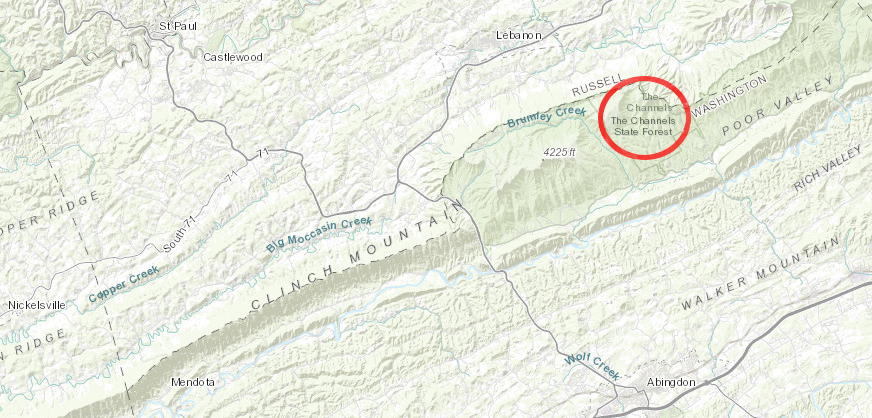
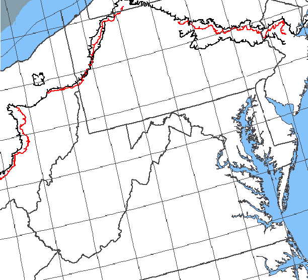
the ice sheet that stopped in Pennsylvania affected the creation of The Channels over 200 miles away
Source: ESRI, ArcGIS Online
Glaciers did not carve the landscape in southwestern Virginia, but the Ice Age climate (as well as earthquakes) may have been a factor in creating the largest known landslides in eastern North America. For 20 miles, land has slumped along the eastern slope of Sinking Creek Mountain west of modern-day Blacksburg.
When the climate was colder, vegetation was less and erosion was evidently higher. Soil washed away at the base of rock layers on the mountain, and earthquakes may have triggered a series of massive landslides until 10,000 year ago.8
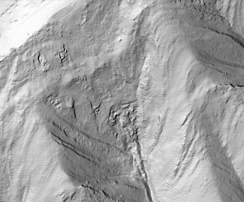
LIDAR reveals landslides on Sinking Creek Mountain that modern forest cover obscures
Source: US Geological Survey (USGS), The National Map
Icebergs floated past the coastline of Virginia about 31,000 years ago, after a pulse of cold water escaped from the edge of the ice sheet near Hudson Bay. Barriers of ice which had dammed up lakes melted during different short-term warming periods and a flood of water/ice was released, similar to the way the Channeled Scablands in the State of Washington were created.
Another possibility is that the high rate of icebergs calving off the front of the ice sheet was triggered by intermittent advances and retreats of the ice sheet, known to scientists as Heinrich Events. Surges of icebergs floating as far south as Florida could have been caused by warming of the ocean at the ice sheet edge, due to disruptions in the flow patterns of the Atlantic meridional overturning circulation (AMOC) and North Atlantic deep water (NADW).
Six "Heinrich Events" during the Wisconsin stage have been identified by layers of ice-rafted debris. On an average of every 5,000–6,000 years, these Heinrich events lasted about 500 years. The first Paleo-Indians camping on Virginia's Atlantic Ocean shoreline would have seen icebergs stranded and floating offshore 18,000-15,000 years ago during Heinrich Event 1.
The current of cold water which flowed south was powerful enough to counter the north-flowing Gulf Stream and carry glaciers as far as the Florida Keys. There are 700 lines today that scour the bottom of the Atlantic Ocean off the East Coast, showing where ocean currents dragged glaciers across the seafloor.
Today the scour lines are 557 feet-1,246 feet deep, but the icebergs did not have to be that tall in order for their keel to reach those depths. At the time the glaciers flowed south, water levels were roughly 400 feet lower.
The icebergs dug trenches into the sediments as much as 60 feet deep. That depth suggests some icebergs plowed into ridges on the ocean bottom and became stuck in place, then melted partially and floated away.9
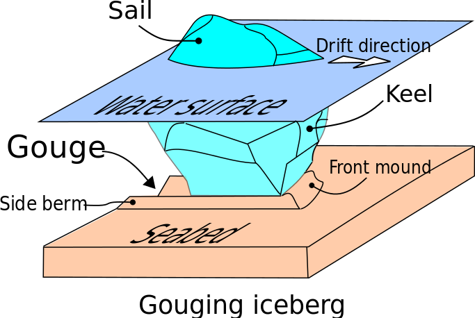
icebergs gouged into sediments at the bottom of the Atlantic Ocean off the Virginia shoreline until the ice sheet retreated and the Gulf Stream was established
Source: Wikipedia, Seabed gouging by ice
Ice did not etch out the Chesapeake Bay in the way that the Great Lakes were formed; the ice sheet never reached that far south. However, expansion and melting of the ice sheet over 400,000 years did shape formation of the bay by triggering development of the Delmarva Peninsula. The climate warmed and cooled in stages, and the peninsula expanded in response.
The proto-Susquehanna River and ocean currents brought sediments south from the edge of the ice sheet in Pennsylvania and New York. Those sediments accumulated at the mouth of the proto-Susquehanna River at times of high water flow, when the climate was warming. During periods when the climate cooled again, sea level dropped and previously deposited sediments were exposed on the ocean surface.
The energy of water flowing in the proto-Susquehanna River diminished in the cold periods. Lacking the energy required to cut through the exposed sediments, the proto-Susquehanna River shifted its mouth further south to reach the Atlantic Ocean. With each shift, the length of the Delmarva Peninsula grew further south.
Cycles of rising and falling sea levels created today's Eastern Shore, and that peninsula of land separating the Susquehanna River from the ocean had created the Chesapeake Bay. However, when the climate was colder and sea levels were lower, what is now the Chesapeake Bay was just a valley with the proto-Susquehanna River flowing through it. What is now Tangier Island was a part of a sandy ridge on the eastern side of the river valley, not an isolated island. Cold, strong winds blew off the ice sheet to the north down that river valley.
Sea level has risen since the end of the last cold stage of the Ice Age. Over the last 18,000 years seawater has flooded the southern end of the Susquehanna River valley. Aas the Continental Shelf was gradually flooded, Native Americans living near the Atlantic Ocean shoreline moved their campsites gradually 40 miles to the west. Those living next to the Susquehanna River moved upland, until the Chesapeake Bay reached its current form about 3,000 years ago.10
Warmer, wetter climate led to a transformation of the pattern of plants and animals in Virginia. Spruce and fir trees that prospered together with oaks and pines in cold, dry settings disappeared, or managed to survive primarily on the mountain ridges. The river birches and alders which could survive in the warmer climate remained in stream valleys, but some birch species retreated to just the colder mountains.
The Eastern deciduous forest developed as warm-loving species widened their range from Ice Age refugia in stream valleys, More species of oaks, chestnut, hickories, and many other deciduous trees expanded into the lands once occupied by a:11
Native Americans also adapted to the new climate. Atlantic salmon ceased to migrate into the warmer rivers, but oysters and crabs became available as brackish water drowned the Susquehanna River valley.
Steady winds blowing off the ice sheet no longer kept stinging and biting bugs away from campsites on north-facing slopes in the summer, but there were more food sources available for the seasonal rounds of hunting and gathering. Hunts for mammoths ended as the megafauna went extinct and the forests changed; deer, bear, and turkey became major elements in the diet.
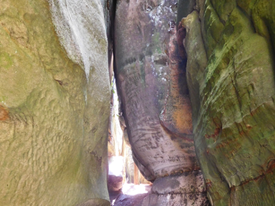
"The Channels" was created when joints and fractures in the sandstone at the top of Clinch Mountain were widened by the freezing and thawing of ice during the Pleistocene
glacial advance... to Pittsburgh, but not into modern-day Virginia
Source: US Geological Survey, National Atlas