Why does your commute suck? If you think the answer is "we need more roads/wider roads," you're thinking in only one dimension.
The traditional political sound bites focus on expanding transportation capacity: "Elect me, and I'll work to build XYZ Road" or "Elect me, and I'll expand Metrorail to Cumberland Gap" or "Elect me, and I'll start a commuter ferry up the Potomac River." (Yes, in Prince William County a supervisor has been sharing a ferry tale for years...)
Think deeper than a political sound bite. The two-dimension answer adresses not just supply, but also demand. We have commuter congestion twice a day because there is a disconnect between where people live vs. where people work. Traffic congestion is a land use as well as a road/transit capacity issue.
If we all lived within walking distance of our jobs, would there be a rush hour on the highway twice a day?
Where to construct new transportation capacity is also a political geography exercise. Roads and transit are funded by gas and sales taxes. Taxes are collected locally, sent to Richmond, and then the state government distributes funds back to different local jurisdictions for various construction projects (as well as operations and maintenance). There is a geographic disconnect between where taxes are collected and where the money is spent.
Northern Virginia (NOVA) generates the most tax revenue of any region in Virginia. The state has allocated some funds for the $1 billion project to replace the Woodrow Wilson Bridge and the $5-6 billion project to build the Silver Line for Metrorail - but NOVA officials claim they are a "donor" region sending more $$$ to Richmond than are returned for NOVA projects.
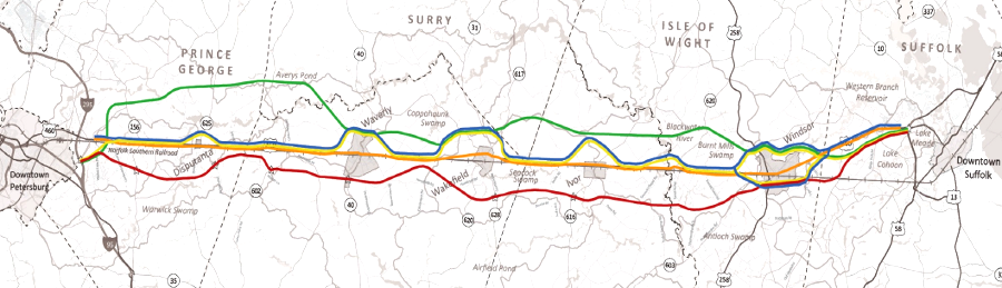
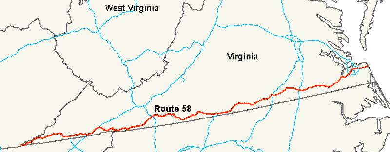
In 1989, the General Assembly increased taxes on every deed recorded at the courthouse, and directed some of that new funding to widen the 2-lane portions of US 58 parallel to the North Carolina border. Since most real estate transactions occurred in fast-growing Northern Virginia, the effect was to shift funding from an urban area to a very rural area. As described by the Daily Press in Newport News:
"The po' country boys from the south beat the rich northern dudes Saturday as the House of Delegates agreed to shake loose an estimated $1.3 billion of jealously guarded road funds to build a modern highway system along the southern boundary of Virginia."1
A Prince William County delegate shouted on the floor of the House of Delegates: "There's going to be a hue and cry across this Commonwealth: 'That's not fair!'"
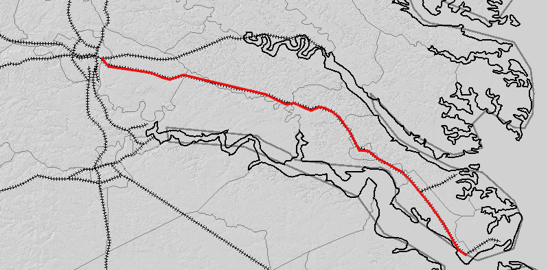
US 58 stretches from the Atlantic Ocean resort hotels in Virginia Beach, along the North Carolina border, to Cumberland Gap
Source: Wikipedia, U.S. Route 58
Who benefits vs. who pays is a political geography game with winners and losers. That game is played in the political arena, sometimes with sharp elbows.
The 2014 General Assembly rejected Gov. Terry McCauliffe's #1 priority, expansion of Medicaid services under the Affordable Care Act ("Obamacare"). The leader of the opposition was Rep. William Howell, the Speaker of the House of Delegates. The governor is a Democrat, the two houses of the General Assembly are controlled by Republicans, and the partisan divide is deep.
Speaker Howell represents the 28th District, including Fredericksburg and much of Stafford County west of I-95.
State revenues were lower-than-expected, so some highway construction projects have been dropped from the next Six-Year Improvement Program of the Virginia Department of Transportation.
Some Fredericksburg/Stafford Republican leaders claimed cuts were deeper in their area due to "political payback," and they were "getting screwed."2
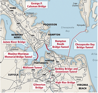
Who do you think should fund the Third Crossing in Hampton Roads, a proposed new bridge-tunnel to cross the James River? It will cost a $5-$6 billion to build a third bridge-tunnel to connect South and North Hampton Roads. Think just the Hampton Roads taxpayers should cover 100% of that cost?
Should Dickenson County residents help pay for that project? Should Hampton Roads residents pay for the Coalfields Expressway?
Sectional politics in Virginia were exposed clearly by the competition to steer state funding towards canals up the James River vs. Potomac River.
The state legislature failed to fund transportation projects in the western counties, in part because construction costs in the mountains were so high. Those counties later split off to form West Virginia - in part over slavery issues, but also in large part over sectional bias in the way taxes were collected vs. spent.
Watershed divides can be overcome by canals... if there's enough money to move enough dirt.
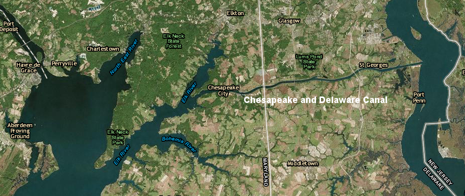
The Susquehana River is separated from the Delaware River, but near the northern end of the Chesapeake Bay the Chesapeake and Delaware Canal cuts through 14 miles of dirt to link the two waterways.
That canal could be considered the northern tip of the Delmarva Peninsula. The southern tip is... well, if you don't know that answer, get out the Virginia Atlas and Gazetteer.
If the Chesapeake and Delaware Canal had existed in 1785, think Maryland would have given Virginia the right to use the Potomac River in the Potomac River Compact?
the northern edge of the Delmarva Peninsula: the Chesapeake and Delaware Canal
Source: ESRI, ArcGIS Online
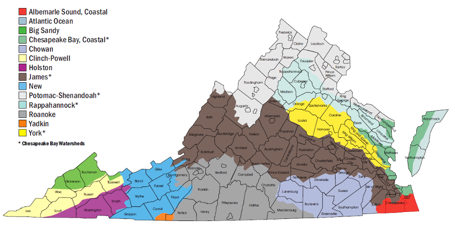
Note the location of the watershed divide between the James River and the Blackwater/Nottoway/Meherrin rivers. Colonial settlement stayed north of that divide for decades; "Southside Virginia" was slow to develop because that region's rivers did not flow to the Chesapeake Bay and it was harder to export crops to markets in the Caribbean, England, or along the Atlantic coastline (Charleston, Philadephia, New York, Boston).
the watersheds of rivers flowing into the Chesapeake Bay were settled before the watersheds of rivers flowing into Albemarle/Pamlico Sound, because the Chesapeake Bay offered easy shipping to Europe while the barrier islands of the Outer Banks made exports more expensive from the Albemarle/Pamlico Sound watershed
Source: Virginia Department of Conservation and Recreation, Watershed Map
Railroads were more cost-effective in shipping freight, compared to 4-horsepower wagons moving on dirt roads that turned into muddy quagmires after a rain.
Railroads carried passengers faster than wagons or horses, but railroad profits were tied to freight shipments rather than carrying passengers.
Few cities are still served by two railroads, so companies seeking to ship freight typically get to compete between rail vs. truck to get a better price.
There is competition between CSX and Norfolk Southern for shipping coal from Southwestern Virginia to customers such as power plants, steel mills, and other industries. Many customers are overseas, so coal is carried by train to Newport News, Norfolk, and Charleston for export by ship.
Individual mines are normally serviced by just CSX or Norfolk Southern, so each mine is a "captive customer" of one railroad, but mining companies can choose to open or close different mines depending upon the shipping rates quoted by competing railroads.
You know now that railroad profits were tied to shipping freight rather than passengers. The Virginian Railroad was designed to make profits by moving coal from mines in the Appalachian Plateau to the port at Norfolk for export. Passengers would slow down trains, so that railroad was designed to minimize grades (the Allegheny Tunnel was bored underneath the mountain on which US 460 connects Christansburg-Blacksburg) and to avoid going through towns in the Piedmont.
Interstate highways were built with Richmond/Petersburg as the hub; Lynchburg was bypassed in part because of politics. Was Harrisonburg bypassed for the same reason?
There were far more people living in the Shenandoah Valley west of Massanutten Mountain than in the portion to the east (also known as "Page Valley"). Why did the Norfolk and Western Railroad build its track on the eastern side of Massanutten in 1881?
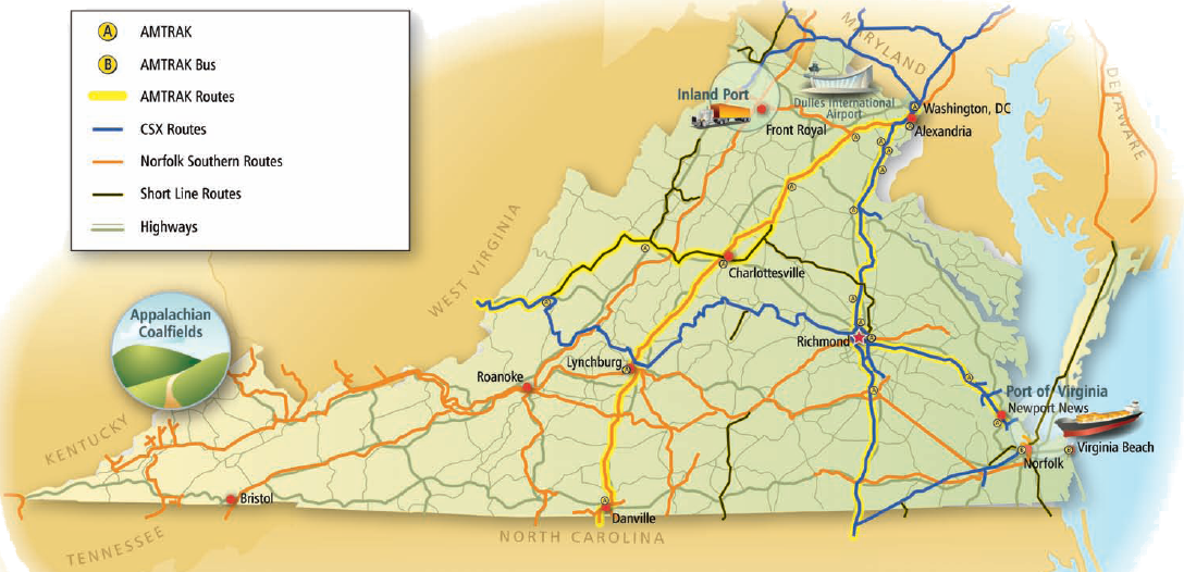
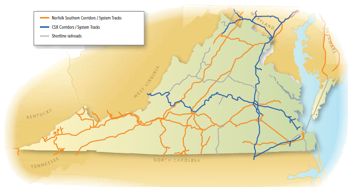
CSX (blue) and Norfolk Southern (orange) are the two remaining Class 1 freight railroads in Virginia
(NOTE: map does not show all blue lines - CSX also serves coal mines and other freight shippers in southwestern Virginia)
Source: 2008 Virginia State Rail Plan
The resurgence of passenger rail is financed by government subsidies. Federal and state grants provide nearly 100% of the funding for capital budgets, used to purchase locomotives/passenger cars and construct new passenger stations.
Government grants also subsidize operations and maintenance. It is unusual that farebox revenues (from ticket sales to passengers) are sufficient to fund operational costs for the Amtrak train to Lynchburg. When a VRE passenger buys a ticket, government grants pay almost the same amount of money for that trip.
CSX and Norfolk Southern railroads in Virginia would prefer to carry just freight traffic, but recognize the political necessity to lease their tracks to Amtrak and Virginia Railway Express (VRE).
Expansion of Amtrak/VRE service on the CSX tracks between Richmond-DC is constrained by the ability of CSX to keep a safe distance between trains, and by the quality of the track.
On hot summer days, the track can expand and "kinks" in the rail can cause trains to derail. Speeds are dramatically reduced (as slow as 10mph vs. 79 mph). Amtrak/VRE customers complain about delays, but CSX is listening most closely to the threats of freight customers to shift to trucks or ships.
Roads are not cheap, but tolls make the users pay. Private companies are building new highway lanes, such as the ExpressLanes on I-95 and the Capital Beltway, because users will pay enough in tolls for the investors to make a profit. Yes, for-profit roads are here.
Trains are not cheap either. Do commuters on VRE pay the full cost of the train service?
If you think "transit is good, paving new highways through the forest is bad," be sure to define who pays vs. who benefits. Subsidies disguise the true cost of providing transit alternatives to widening existing highways or building new roads.
Suburban sprawl continues as new houses are built at the periphery of the urbanized zone in Northern Virginia, on the western edges of Prince William/Fauquier counties or south of Fredericksburg in Spotsylvania County. Workers who live in scattered housing developments, with 1-acre lots, have one reasonable option for commuting to work: drive. If housing is concentrated so there are 10-40 condos or apartments per acre, then there may be enough people at one location to justify a bus stop or a rail station.
New trains on VRE at rush hour would add to the supply of transportation capacity. Transit Oriented Development is still development, adding new commuters to some location, but getting more people to take transit is one way to reduce the demand for building new highways. If 100 workers move into a new community built around a VRE station and 35 of those workers take the train... then traffic congestion on the highway still increases, but not so much as if all 100 workers drove to work individually.
double-stacking cargo containers on trains is the equivalent of adding a second trailer to a truck on the highway, except trains get higher and trucks get longer
Source: Federal Highway Administration
Transportation and land use are linked; one affects the other. If we zone land so houses are built in Stafford, but jobs are concentrated in Tysons/Alexandria/Arlington/DC, then we create a demand for widening I-95 with High Occupancy Toll (HOT) lanes and adding a third track between Fredericksburg-DC so VRE trains can avoid CSX freight traffic. Funding the cost of additional transportation infrastructure requires higher taxes.
Advocates for smart growth, transit-oriented development, and walkable communities are often enviromentalists and politicall-liberal, focused on saving open space and using the power of government to zone land to improving the quality of life for urban residents. There is often a political alliance between smart growth advocates and low-tax conservatives on land use and transportation issues, which are typically decided by local and state officials. There may be a deep partisan divide at the national level, but local and state land use/transportation issues often reveal unusual partnerships.
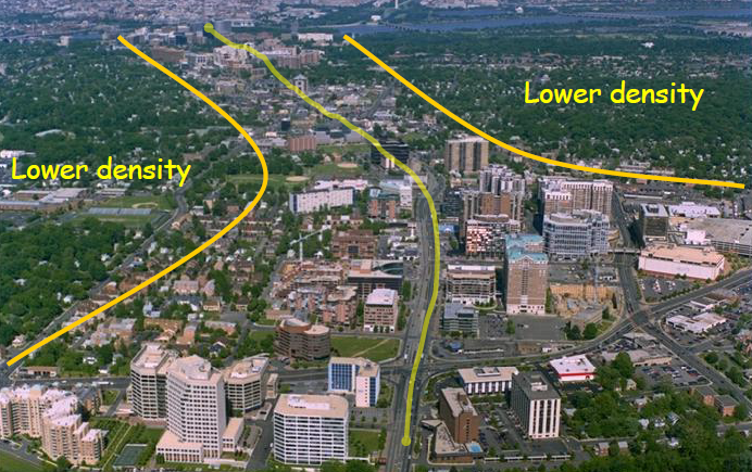
Arlington's General Land Use Plan (GLUP) created dense, mixed-use development at the new Metro stations. Density is the key, compared to scattered development on large lots (with white picket fences and a dog...) in Spotsylania County or west of Route 15 in Loudoun County.
Dense developments do not need to be architecturally boring or repetitive. The large apartment blocks built in Eastern Europe during the era of the Soviet Union are appallingly dull, but Arlington seeks to stimulate creative and vibrant places to live next to Metro stations. Concentrated development at individual stations was shaped by "sector plans" to establish a distinct sense of neighborhood community.
Zoning incentives spurred developers to construct transit-oriented projects, and today Arlington's traffic congestion has been minimized despite dramatic population growth - because people walk to work, or take the train. A crowded Metro train can move 900 people. There is no way Arlington could handle the current population near Ballston-Rosslyn if 95% of residents drove to work, as in Prince William County.
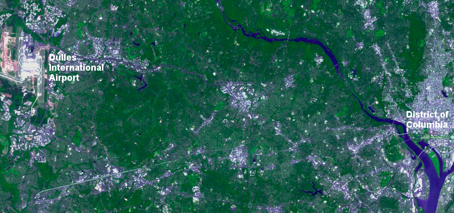
land use and transportation patterns, from DC to Dulles International Airport
Source: US Geological Survey New Earth Explorer
Fairfax County missed its original opportunity to have the Metrorail link Tysons to DC. Instead, Fairfax officials placed the end of the Orange Line in an empty field near Vienna... and then zoned the land around that station for low/moderate density development.
In contrast, Arlington County paid extra to have the Orange Line stations built on Wilson Boulevard/Fairfax Drive. Arlington's long-range land use and transportation planning in its General Land Use Plan (GLUP) authorized dense development within 1/4 mile of new Metro stations between Rosslyn-Ballston.
Encouraging dense development next to Metrorail revitalized low-density commercial strips and created what today is a world-class example of transit-oriented development. 40% of people living within 1/4 mile of the Orange Line (and with the high-rises, that's a lot of people...) do not drive to work; 16% of households own no car. Zip Car and other car-sharing choices are widely available, when people want to take a day trip in October to see leaves turn color at Shenandoah National Park.
Norfolk and Virginia Beach are always trying to attract an NBA basketball team. Every existing NBA team seeking to get more public funding to build a new arena in their town - Charlotte, New Orleans, Sacramento, wherever - threatens to move to Hampton Roads.
You're a Virginia geographer now. Why don't any of the top-tier professional teams actually chose to move to Hampton Roads?
route of C&O (now CSX) railroad from Richmond to port at Newport News (with extension to Hampton)
Source: The National Map Seamless Data Viewer
Today, political debates are often about widening I-66 or building more bridges across the Potomac River. The Washington Post, the dominant newspaper in Northern Virginia, constantly advocates for increased infrastructure - and real estate advertising is fundamental to that newspaper's business model.
If new bridges were constructed across the Potomac River upstream of the American Legion Bridge and downstream of the Woodrow Wilson Bridge (the bridges carrying the Beltway over the river), who would benefit? Who would pay?
Three roads projects reflect the perspective that "if you build it, they will come" - but do you think that's true? Would you buy into these projects with your own personal money?
Who do you think should fund the Coalfields Expressway? It will cost a $2.8 billion to link Pound to Beckley, WV. Think just the Wise/Dickenson/Buchanan county taxpayers should cover 100% of that cost? Should Hampton Roads residents help pay for that project?
The Virginia Department of Transportation (VDOT) has engineers and other specialists on staff, but the agency's top leaders are sensitive enough to political trends to justify spending $300 million on a new 55-mile long highway... and then justify cancelling that very same project six months later, before a single inch of new road was constructed.
What lesson does that teach, regarding the reliability of studies and feasibility studies produced by VDOT?
Will the Silver Line increase freight traffic to Dulles?
Drivers on the Dulles Access Road pay for the Silver Line, at every toll booth. Virginia politicians feared the reaction of drivers who had to pay ever-increasing tolls, so they transferred the toll road to the Metropolitan Washington Airports Authority. Elected officials can now blame MWAA for those high tolls...
Web Exercise:
Explore the 1895 map of Virginia from the Color Landform Atlas of the United States. Check out the areas of Virginia that you know today, and examine the pattern of transportation route and populated places (cities/towns). How have things changed over the last century in Northern Virginia and Hampton Roads, compared to the route 58 corridor from Lee County east to Southampton County?
Can you find the route of today's Washington and Old Dominion bikepath on this 1895 map?
(hint: look for the Southern Railroad line, between Alexandria and Round Hill)
Source: 1895 map of Virginia from the Color Landform Atlas of the United States
Map Exercise:
- In the Virginia Atlas and Gazetteer, start at Glen Lynn in Giles County. Follow the Norfolk Southern tracks upstream along the New River on the north bank (if you were floating downstream, the tracks ould be on your right...). Go uphill to the Radford Army Ammunition Plant, then up Slate Branch to the Allegheny Tunnel. Go under US460, crossing the Eastern Continental Divide. Follow the tracks downhill along the North Fork of the Roanoke River, then east along the Roanoke River through the gap in the Blue Ridge. NOTE: a separate rail line parallels US460 to Lynchburg; don't go that route.
Go along the Roanoke River through Moneta to Altavista to Brookneal. Start going uphill again east of Brookneal, climbing out of the Roanoke River valley and crossing the watershed divide. Go east to Phenix in Charlotte County, then on to Abilene. Follow the watershed divide (railroad engineers were very conscious of topography; trains do not go uphill/downhill efficiently...) to Meherrin. Turn south and trace the Meherrin/Nottoway River divide to Victoria, Kenbridge, Dolphin...
Ever heard of these places? Ever heard of a railroad that *avoided* population centers, limiting potential freight and passenger traffic? What sort of business model could have guided the design of the Virginian Railroad?
Keep going eastward. Cross Interstate 85 at Alberta, then leave Greensville County at Jarrett. Go east (on a now-abandoned route) across Southampton County to Kilby, where you cross Route 58. Skirt the edge of the Dismal Swamp, cross the Southern Branch of the Elizabeth River, and swing north through the urbanized area. Cross the Eastern Branch of the Elizabeth River and swing left through Norfolk to the piers at Sewell's Point (now the US Navy base).
Congratulations, you just traced the route of the Virginian Railroad, built to carry coal from West Virginia to export docks in Norfolk. Hauling coal from the mines in the mountains directly to the port was more profitable than hauling passengers, or stopping/starting to pick up freight cars. The Virginian Railroad was designed for one purpose: move coal very, very cheaply.
bridges and tunnels in Hampton Roads
AMTRAK uses CSX tracks between DC-Newport News, but pays Norfolk Southern to use the tracks between Alexandria-Danville
(Who owns the tracks used for AMTRAK's new service between Petersburg-Norfolk, on the straight line south of the James River?)
Source: 2008 Virginia State Rail Plan
How did the transportation network develop at your site? Roads let people go from one place to another - so what were the destinations associated with your roads? Where was your Plan B, if you wanted to ship your products to a different destination in hopes of getting a better price?
Think there were any "rolling roads" to carry tobacco to a wharf on a nearby riverfront, for shipping to England? If you were a farmer in the 1800's, where would you have shipped your crops to market? (Today, is the modern export from your site a line of commuters driving to work?)
How close is the nearest rail line to your site? When the railroad finally was built, did you get more options for shipping to market, or were you still trapped with the same old buyers in the same old place? Think the value of land at your site went up in value, compared to places further away from the rail line?
What transportation improvement today would increase the value of land at your site? Assuming the General Assembly will not raise the gas tax or fees for another 25 years, how could that infrastructure be funded? If you think drivers might pay tolls, how much do you think you could charge? Road projects are expensive - the proposed grade-separated interchange at Braddock Road/Route 123 (next to Fairfax campus) is projected to cost over $80 million. How could implement a toll system for the transportation improvement project at your site - and if that's not feasible, how could you generate the funding? No, "just raise taxes" is not a viable proposal in today's political climate.)


 land use and transportation patterns, from DC to Dulles International Airport