Northwest Territory
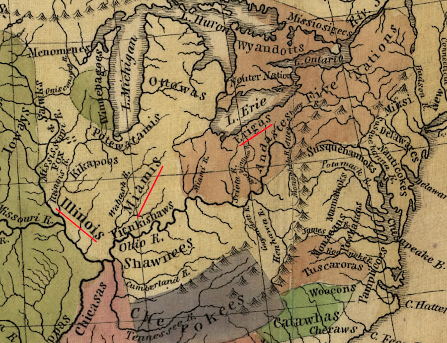
the French encountered the Erie, Illinois, and Miami tribes in the late 1600's as they first explored the lands west and south of Lake Erie
Source: Library of Congress, Map of the Indian tribes of North America, about 1600 A.D. along the Atlantic, & about 1800 A.D. westwardly (Albert Gallatin, 1836)
Before Europeans provided firearms to the Iroquous (Huadenosaunee), what became known in the 1700's as the Northwest Territory was occupied primarily by the Fox and Mascouten ("Fire People") in the northwest, the Illinois and Miami tribes in the west, and the Erie in the east.
the territory morthwest of the Ohio River was occupied by various Natve American groups ever since the ice sheet retreated over 10,000 years ago
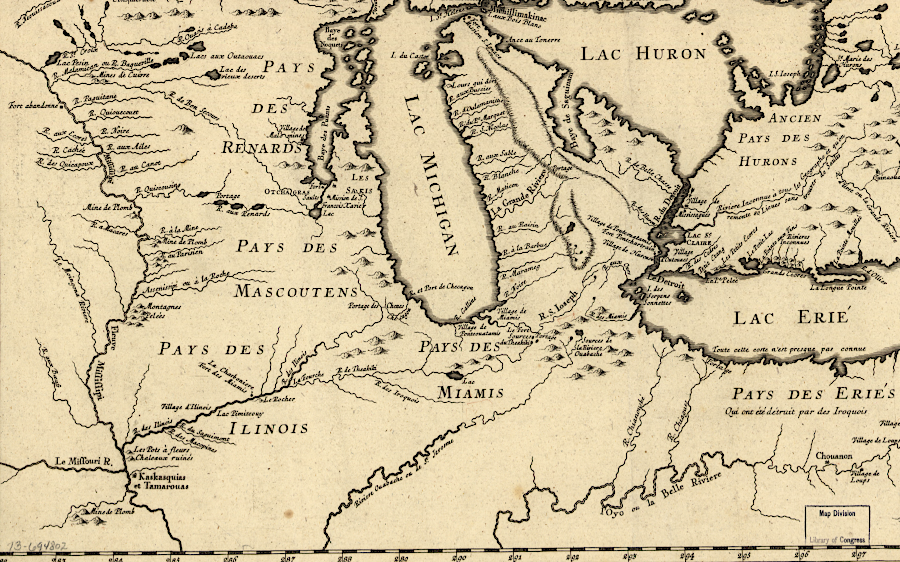
Source: Library of Congress, Partie occidentale de la Nouvelle France ou du Canada (by Jacques Nicolas Bellin, 1755)
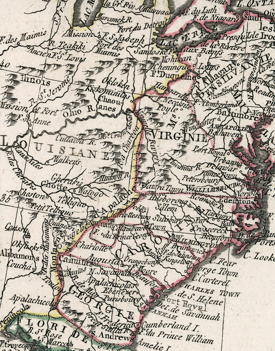
Native American tribes manipulated the French and British until 1763, changing alliances to get trading benefits and preserve territory
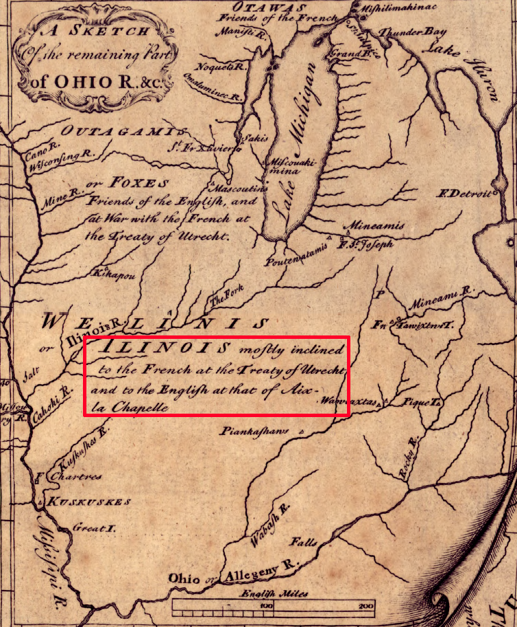
Source: Library of Congress, A general map of the middle British colonies, in America (Lewis Evans, 1755)
The first European nation to claim ownership of the Northwest Territory was Spain, but it made no effort to occupy the area in the 1500's. The French claimed ownership of the Mississippi River watershed based on their initial "discovery" and exploration starting with fur traders around the Great Lakes in the 1650's. Father Jacques Marquette and Louis Joliet paddled down the Mississippi River in 1673. Travelling originally from Quebec, Ren-Robert Cavelier Sieur de La Salle reached the mouth of the Mississippi River in 1683.
The Virginia colony claimed ownership of the Mississippi River watershed and all the land west to the Pacific Ocean region based on the Second Charter issued by King James I in 1609. Just that portion of the claim east of the Mississippi River totaled 469,000 square miles. Modern Virginia boundaries include just 42,755 square miles.1
The Massachusetts colony asserted ownership based on its 1620 charter. The Connecticut colony later claimed a slice as well. However, English Efforts to settle lands west of the Shenandoah Valley began only after the Haudenosaunee (Iroquois) agreed to cede land claims in the 1744 Treaty of Lancaster.2
The French claim was extinguished by the British victory in the French and Indian War, with formal relinquishment in the 1763 Treaty of Paris. The overlapping claims of different English colonies were finally resolved by each state ceding its western land claim to the national government with Virginia beiing the last in 1783. The Continental Congress then established the Northwest Territory with a Land Ordinance in 1784.
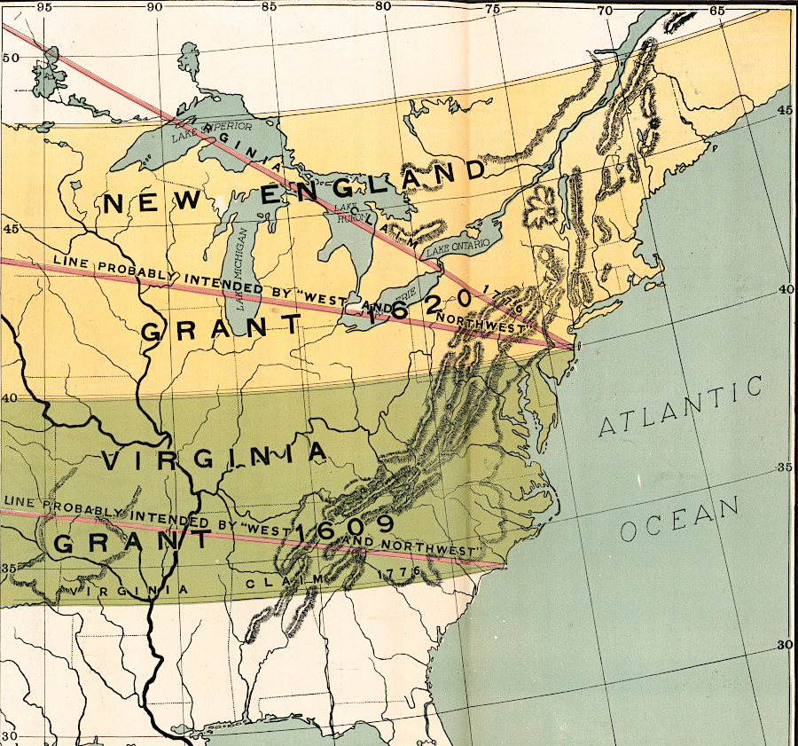
if the French had won the French and Indian War in 1763, the 1604 grant to de Monts might have shaped the boundaries of the United States
Source: Library of Congress, The comprehensive series, historical-geographical maps of the United States - Early land grants (1919)
For English colonists living south of Lake Ontario, access to the Ohio River and the Northwest Territory beyond it was easiest by way of the Forks of the Ohio. Settlers began to establish Pittsburgh when the Ohio Company started a fort there in 1753.
The French chased away the Ohio Company workers in 1754, as George Washington was leading Virginia troops westward to protect them. After a brief fight with a French force at Jumonville Glen, Washington retreated towards Virginia. The French caught up with him. He was unable to defend his quickly-built Fort Necessity and had to surrender. The French proceeded to build Fort Duquesne at the Forks of the Ohio, with walls strong enough to withstand artillery bombardment. By the end of 1754 the French had made arrangements with the Native Americans and expelled the British, establishing dominance of the entire Mississippi River watershed.
That same route was followed by British General Edward Braddock in 1755. After his defeat, General John Forbes led the third campaign in 1758 to capture the Forks of the Ohio. He chose to build a road from the Susquehanna River westward through Pennsylvania, rather than use Alexandria as his supply base and assemble his forces at Fort Cumberland in Maryland. Washington and other Virginians recognized that the Forbes Road would provide direct access to the Ohio River. The military decision by General Forbes was a gift to Pennsylvania traders and land speculators seeking to profit off western lands.3
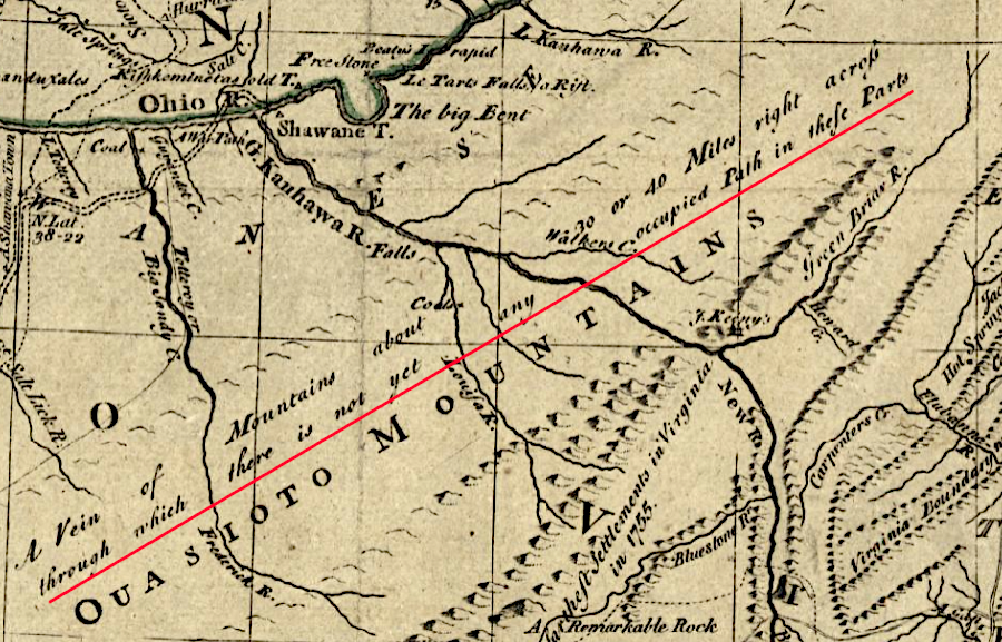
topography blocked easy access from Virginia to lands along the Ohio River; the best route was via the Forks of the Ohio
Source: Library of Congress, A general map of the middle British colonies, in America (Lewis Evans, 1755)
a decade after the 1783 Treaty of Paris, Europeans considered the western territory acquired by the United States as unsettled land
Source: David Rumsey Historical Map Collection, Les Etats Unis de l'Amerique septentrionale (1793)
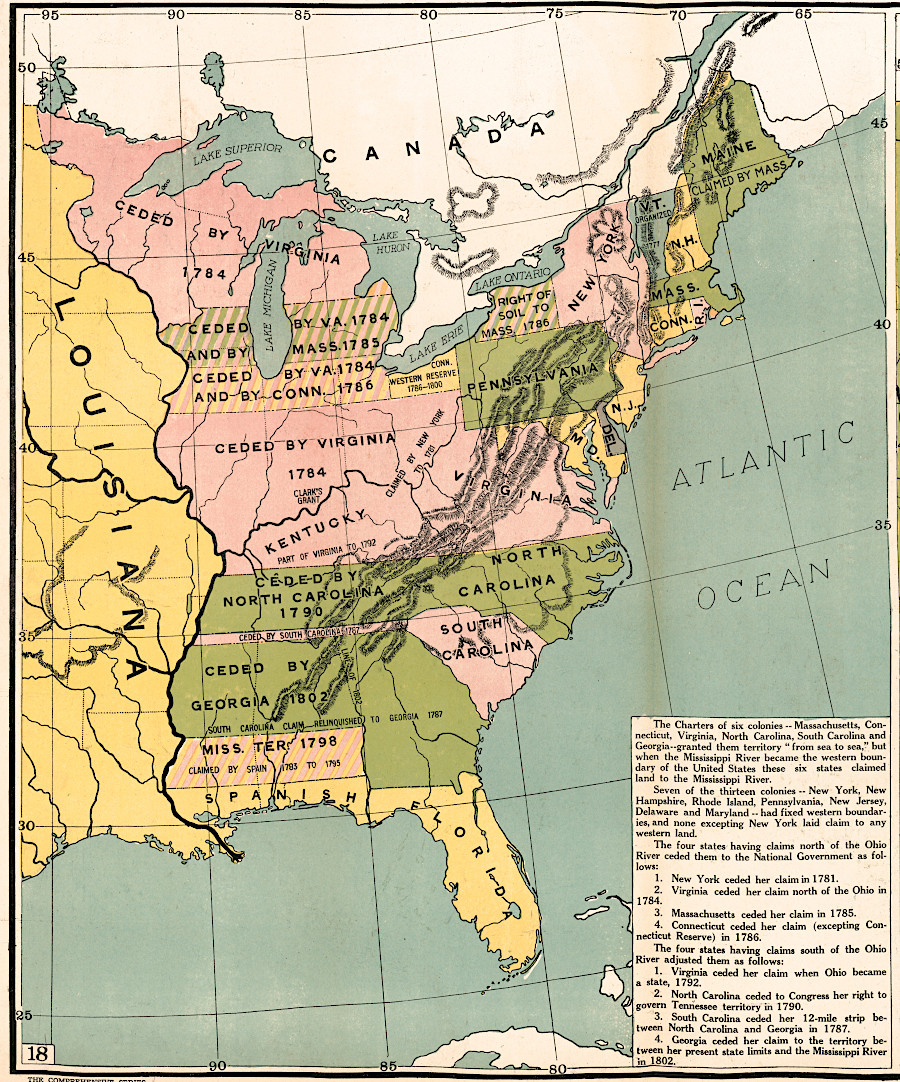
four states claimed the lands of the Northwest Territory, based on colonial charters or conquest
Source: Library of Congress, The comprehensive series, historical-geographical maps of the United States (1919)
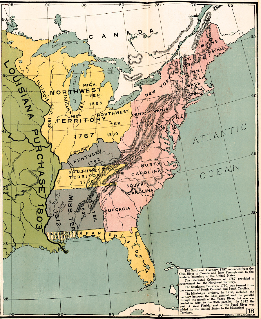
the Land Ordinance of 1785 and the Northwest Ordinance of 1787 guided disposal of the public domain and creation of new states from the Northwest Territory
Source: Library of Congress, The comprehensive series, historical-geographical maps of the United States (1919)
Links
References
1. "Virginia", Census Bureau, https://data.census.gov/profile/Virginia?g=040XX00US51; "Could Virginia (which once included Detroit) have become a mega state?," Cardinal News, January 13, 2026, https://cardinalnews.org/2026/01/13/could-virginia-which-once-included-detroit-have-become-a-mega-state/ (last checked February 1, 2026)
2. "Treaty of Lancaster," University of Nebraska-Lincoln, in "Envisaging the West: Thomas Jefferson and the Roots of Lewis and Clark," http://jeffersonswest.unl.edu/archive/view_doc.php?id=jef.00083 (last checked August 22, 2016)
3. Alfred P. James, "The Role of Virginia and Virginians In the Early History Of Southwestern Pennsylvania," The Western Pennsylvania Historical Magazine, Volume 34 Number 1 (March 1951), p.57, https://journals.psu.edu/wph/article/view/2367/2200 (last checked August 23, 2016)
Exploring Land, Settling Frontiers
"Indians" of Virginia - The Real First Families of Virginia
Virginia Places