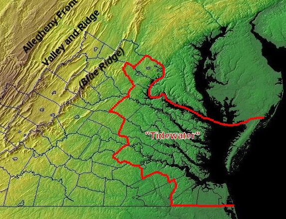
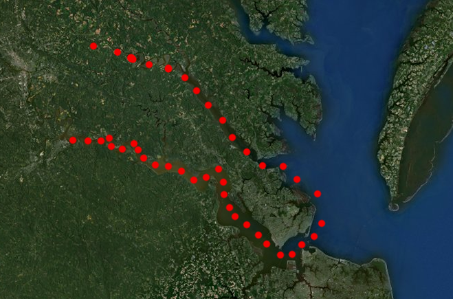
Physically, Tidewater is the region where rivers are affected by the rise/fall of tides
(but culturally, Richmond/Petersburg may belong more to Central Virginia and Alexandria to Northern Virginia)
Source: USGS National Atlas
Tidewater can be defined by different boundaries, depending upon your point of view.
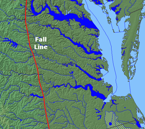
A geologist may define Tidewater as the area east of the Fall Line, east of the crystalline rocks of the Piedmont. An astronomer may consider Tidewater to be the area where the water level rises and falls each day based on the gravitational pull of the moon (and the sun, too).
An ecologist may start talking about the Chesapeake Bay estuary, or the downstream end of watersheds (including the mouths of the rivers) east of the Fall Line. A historian may consider Tidewater to be the location of early Colonial settlement around the Chesapeake Bay up to the 1730's. (In that case, Alexandria would be not be a Tidewater community, because Alexandria was not chartered until 1749.)
Physically, Tidewater is the region where rivers are affected by the rise/fall of tides
(but culturally, Richmond/Petersburg may belong more to Central Virginia and Alexandria to Northern Virginia)
Source: USGS National Atlas
A voice coach might recognize certain accents ("let's go to the riv-ah and catch some fish...") as being associated with Tidewater Virginia. A politician, business owner, or government official in southeastern Virginia may tell you that Tidewater is a region with a complex mix of official jurisdictions; the waterways and history of settlement have fragmented the communities into separate cities/counties.
If you drive down I-64 east of Williamsburg, it's very difficult to identify the boundaries of Newport News, Hampton, Norfolk, and Virginia Beach. You may see the signs to Poquoson... but how do you know you've reached it?
If you head west from Virginia Beach, the edges of the political jurisdictions of Norfolk, Portsmouth, and Chesapeake are no more obvious than what you saw driving east. The region's political boundaries resemble Los Angeles, with separate urbanized jurisdictions adjacent to each other and little undeveloped farmland separating the cities. The city lines blur in a sea of monotonous urban development - except for the Eastern Shore. That area is still undeveloped at the moment, though a reduced toll on the Chesapeake Bay-Bridge Tunnel may encourage more commuters to live in Northampton County.
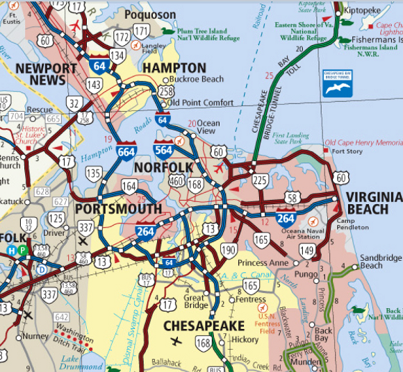
highway map of Hampton Roads
Source: Virginia Department of Transportation (VDOT) Official State Transportation Map
When Tidewater Virginia is defined as a cultural region, the boundaries lack scientific precision. Some people consider the Eastern Shore, the Northern Neck, the Middle Peninsula, the Peninsula, and the portion of Hampton Roads south of the James River to be "Tidewater." Others think "Hampton Roads" and "Tidewater" are the same, excluding the Eastern Shore.
Some consider Tidewater to be just the portion of Virginia that is:
1) east of the Fall Line, and
2) between the James and Potomac rivers, and
3) west of the Chesapeake Bay
That definition would exclude the Eastern Shore, as well as Virginia Beach, Norfolk, Portsmouth, and other jurisdictions south of the James River. You may hear people discuss "Tidewater and Hampton Roads," to include specifically the Chesapeake Bay watershed south of the James River.
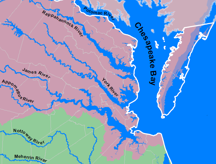
the eastern part of the Eastern Shore is not in the Chesapeake Bay watershed (with the light purple color)...
but is it in "Tidewater"? What about the land south of the James River?
Source: Virginia Department of Game and Inland Fisheries, Virginia Watersheds
The Virginia Marine Resources Commission uses its definition of Tidewater to determine where saltwater fishing licenses are required:
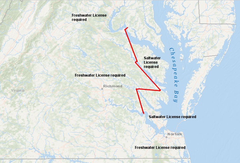
the Virginia Marine Resources Commission defines the lines on tidal rivers where a Freshwater vs. Saltwater license is required
Source: ESRI, ArcGIS Online
All definitions are correct - and all definitions are wrong. Cultural regions are defined in different ways by different people, and there is no official judge sitting in big chair at the front of an International Court of Regional Boundaries to make "official" decisions.
At times, a clear boundary is essential. To identify the portion of Virginia that would be affected by the Chesapeake Bay Preservation Act, the state defined "Tidewater Virginia" to include the following jurisdictions:1
What's missing? The cities of Manassas and Manassas Park, the counties of Loudoun and Fauquier - and other jurisdictions in the Piedmont, Blue Ridge, and Valley and Ridge provinces, where the rivers drain into the Chesapeake Bay but the water levels are not affected by tides.
Tidewater Virginia, as defined in the Chesapeake Bay Preservation Act, excludes Loudoun County
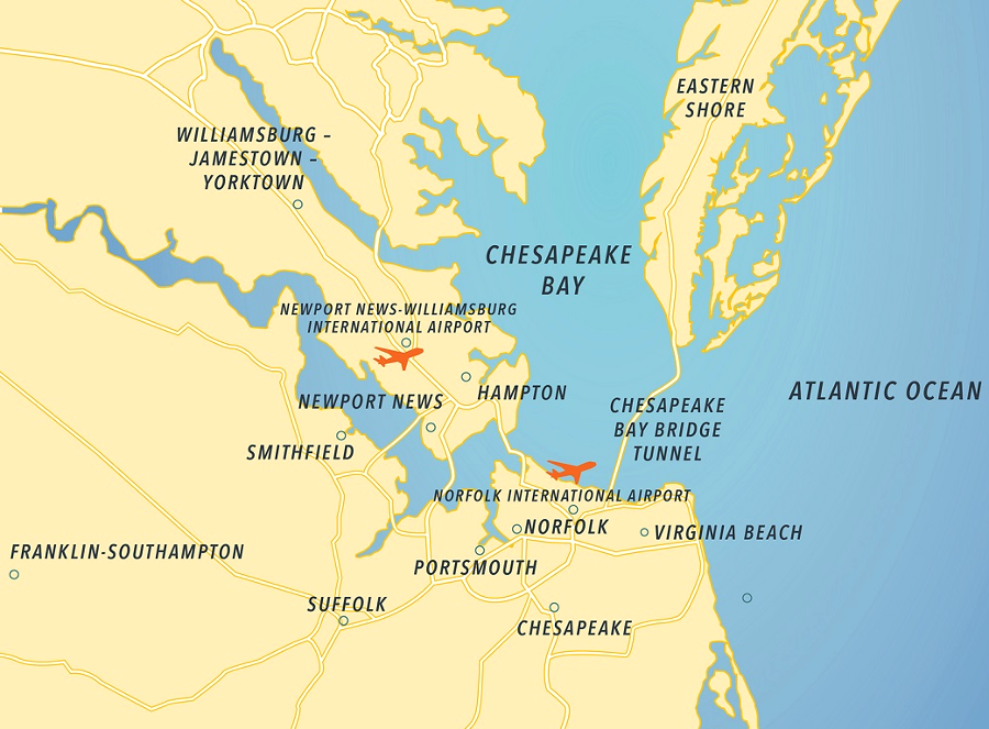
Even defining the edge of Hampton Roads can stimulate a geography debate. The Hampton Roads community is split into two major components, as represented by the location of the regional airports - one on the Peninsula at Newport News-Williamsburg, and one in Norfolk. If someone south of the James River says they are going to the airport, you can generally assume that they are going to the Norfolk International Airport. Someone living north of the James River will probably use the Newport News-Williamsburg or Richmond airports, avoiding the traffic delays at the Hampton Roads Bridge-Tunnel.
The airports in Newport News-Williamsburg and Richmond are growing as the population in Hampton Roads increases. However, so long as the region has three small airports, Hampton Roads is unlikely to attract a carrier to offer nonstop flights to Europe. Southeast Virginia residents will have to keep going to Dulles or Raleigh-Durham airports to fly direct to London; the "international" in the names of southeast Virginia airports reflects the ability to reach other countries after stopping at another airport.
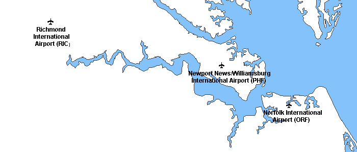
none of the airports in southeastern Virginia have "Hampton Roads" in their name
Source: National Atlas
Another clue to the impact of the waterways fragmenting the population - there is no culturally-unifying professional sports team in the region. Back in 2000, one source described the problem as follows:2
Regional transportation projects can knit together the interests of different jurisdictions in a region, but getting separate jurisdictions to adopt common priorities and then direct funding according to those priorities requires a structural, long-term approach. In 2014, the General Assembly created the Hampton Roads Transportation Accountability Commission to do just that.
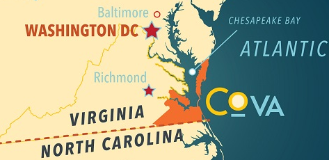
The mayor of Virginia Beach proposed a quicker approach. He offered a marketing proposal to re-brand the region by changing the name from "Hampton Roads" to "Coastal Virginia." An official at Old Dominion University then suggested renaming the region with a more-specific title, "Virginia Beach-Norfolk Metro Area," because:3
re-labelling Hampton Roads as Virginia Beach-Norfolk Metro Area would clearly exclude the Peninsula, between the York and James rivers
Source: ESRI, ArcGIS Online
A local banker then carried the concept to extremes, perhaps only partly in jest. He suggested lumping Williamsburg and Richmond with the rest of the Peninsula and South Hampton Roads:4
It was not the first effort to rebrand the region. Business and civic leaders lobbied successfully to have the US Post Office change the postmark from "Tidewater" to "Hampton Roads" in 1983. In 1996, the Hampton Roads Partnership initiated a rebranding campaign. Rather than refer to Tidewater, Norfolk-Virginia Beach-Hampton-Newport News, or just Hampton Roads, the Hampton Roads Partnership proposed adding the tag line America's First Region.5

1996 rebranding focus: add America's First Region to Hampton Roads
Source: Hampton Roads Partnership, The Campaign - Hampton Roads, Americas First Region
In 2014 the Hampton Roads Planning District Commission conducted a poll on how residents within the region described where they lived, when traveling outside the region. The intent was to determine if there was a consistent "sense of place," and if a regional identity was more important that the particular jurisdiction where a person lived.
The new descriptor, "Coastal Virginia," ended up with few advocates. The name of the jurisdiction with the largest number of people, "Virginia Beach," clearly dominated over "Norfolk area." Only 5% of people interviewed described themselves as being from "Tidewater."6
The Hampton Roads Planning District Commission's effort to re-examine the name "Hampton Roads" led to the Coastal Virginia Tourism Alliance. Even though it did not resonate as a descriptor for the region among local residents, "Coastal Virginia" ended up as a name for a regional tourism marketing group and even a regional magazine. The members of the Coastal Virginia Tourism Alliance included Williamsburg, York County, Newport News and Hampton on the Peninsula. Gloucester County and other jurisdictions north of the York River were excluded. South of the James River, the alliance stretched from Surry and Southampton counties on the west to Virginia Beach, and sout to the North Carolina border. Both Accomack and Northampton counties on the Eastern Shore were also members of the Coastal Virginia Tourism Alliance. The name "Coastal Virginia" was:7
In 2016, The Virginian-Pilot published yet another a proposal, with the headline reading "What's in our name? Not enough." The proposed solution was different from previous suggestions, but equally narrow:8
Also in 2016, the General Assembly created the Growth and Opportunity Board (GO Virginia) to spur private-sector growth in partnership with local governments. To force regional cooperation, the GO Virginia Board established nine Regional Councils for approval of funding for projects. In southeastern Virginia, Region 5 included the same jurisdictions as "Coastal Virginia" except for Surry County. One of the first recommendations from the Tourism and Recreation Cluster Committee of the GO Virginia Regional Council for Hampton Roads was to adopt a new name for the region. The committee concluded that for tourism:9
At the 2018 Coastal Virginia Hospitality Expo, Colonial Williamsburg positioned itself as part of the Hampton Roads region. That tourism destination had been struggling financially, which increased its incentive for partnering with others to draw tourists. A real estate lawyer representing Virginia Beach clients commented: 10
Chesapeake BayEastern ShoreHampton Roads"The Northern Neck" Is Not "The Peninsula"Tidewater and Shipping
Links
References1. "§ 62.1-44.15:68. Definitions," Cide of Virginia, Title 62.1 - Waters Of The State, Ports And Harbors, http://leg1.state.va.us/cgi-bin/legp504.exe?000+cod+62.1-44.15C68 (last checked October 17, 2013)2. "Geography of Pro Sports in the U.S. and Canada," About.com - Geography, http://geography.about.com/library/weekly/aa042700a.htm (last checked August 31, 2011) 3. "Change the region's name again? Panelists split," The Virginian-Pilot, March 23, 2014, http://hamptonroads.com/node/710920 (last checked April 18, 2014) 4. "What's in a name? | Hampton Roads," The Virginian-Pilot, June 6, 2008, http://hamptonroads.com/2008/06/whats-name-hampton-roads (last checked April 18, 2014) 5. "2014 Power List - J. Morgan Davis," Hampton Roads Business Brief, Friday, May 1, 2014, http://insidebiz.com/node/390441 (last checked May 2, 2014) 6. "Welcome to ... what do you call our area?," The Virginian-Pilot, June 26, 2014, http://hamptonroads.com/node/720765 (last checked June 27, 2014) 7. "Coastal Virginia Tourism Alliance," DIA, https://www.diainc.com/coastal-virginia/ (last checked December 21, 2017) 8. "Ray Gregory: Whats in our name? Not enough," The Virginian-Pilot, May 29, 2016, http://pilotonline.com/opinion/columnist/guest/ray-gregory-what-s-in-our-name-not-enough/article_41025c0c-aeea-5151-8199-6b369b154899.html (last checked June 8, 2016) 9. "Go Virginia committee says Hampton Roads needs new name," Inside Business The Hampton Roads Business Journal, December 20, 2017, https://pilotonline.com/inside-business/news/economic-development/go-virginia-committee-says-hampton-roads-needs-new-name/article_fd92e722-a088-53a0-bce7-a393bebf1350.html; "Region 5," Virginia Department of Housing and Community Development, http://www.dhcd.virginia.gov/index.php/component/content/article/326.html (last checked December 21, 2017) 10. "Panel suggests ditching Hampton Roads name, more regional teamwork to capture tourism dollars," Southside Daily, February 1, 2018, https://southsidedaily.com/business/2018/02/01/panel-suggests-ditching-hampton-roads-name-more-regional-teamwork-to-capture-tourism-dollars/ (last checked February 2, 2018)
Rivers and Watersheds of Virginia Regions of Virginia Virginia Places |