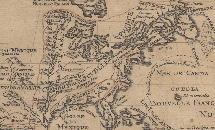
the French, English, Dutch, and even Swedes competed over the trade for furs between the Chesapeake Bay and St. Lawrence River
Source: University of California - The Bancroft Library, L'Amerique septentrionale
the French, English, Dutch, and even Swedes competed over the trade for furs between the Chesapeake Bay and St. Lawrence River
Source: University of California - The Bancroft Library, L'Amerique septentrionale
George Washington's surprise attack on a French force in a Pennsylvania valley (Jumonville Glen) in 1754 started the French and Indian War, but that conflict had been building for over 200 years as different groups of Europeans and Native Americans jockeyed for influence and trade across North America.
The French had claimed territory in North America starting in the 1500's, long before the English tried to settle on the North Carolina coast in the 1580's (and finally managed to start a colony at Jamestown in 1607). Territorial boundaries shifted constantly as French, Dutch, Swedes, and English claimed, controlled, and lost control of land between the Chesapeake Bay and St. Lawrence River.
On the Native American side, the Five Nations of the Haudenosaunee ("Les Cinque Nations des Irquouis") ended up dominating their neighbors in order to control the beaver trade with the French, Dutch and English. The Haudenosaunee/Iroquois gained control over the trade for weapons and claimed authority over what today is Pennsylvania and Ohio prior to the French and Indian War.
Within the English colonial sphere, the New York, Pennsylvania Maryland, and Virginia governments competed for control over the fur trade. Each colony sought to build alliances with different groups of Native Americans. Inter-tribal conflicts between the Susquehannocks, Iroquois, Shawnee, and others were exacerbated by shifting access to colonial weapons and supplies.
European disruption of traditional Native American conflicts in eastern North America was started by the French along the St. Lawrence River in the 1540's. French ships traded guns, cloth, metal tools, and prestige goods for skins of beaver, deer, and other animals at Tadoussac. In 1608, Samuel de Champlain founded the city of Quebec and established a permanent trading presence.
The first Native Americans Champlain encountered while sailing up the St. Lawrence River were Algonquian-speaking tribes. Further to the west he found the Iroquoian-speaking Huron-Wendat. They had access to furs inland, and Champlain initially chose to support them. He did not try to be a non-aligned, peaceful visitor. Instead, Champlain chose sides and helped the Huron-Wendat fight rival Iroquois tribes to the south.
Economics shaped the policy of French settling along the St. Lawrence River. The network of rivers on the north side of the St. Lawrence made it easier to obtain furs from inland sources, and the French preferred the quality of the furs from the Huron-Wendat in the colder north.
French colonists tried to raise crops for their own subsistence, but the growing season was short. Profits in New France always were based upon fur trading rather than agriculture. There was no equivalent in New France to the tobacco-growing, staple crop agricultural economy in Virginia.
the French claimed the Ohio River Valley based on the Right of Discovery, but the Virginia colonists made their own claims based on the 1609 charter from King James I
Source: Wikipedia, French and Indian War (by Pinpin)
The French relied upon various Native American groups living within the interior of New France, west of Montreal, to do the initial hunting and processing of deer skins and furs. Those tribes then exchanged furs with other tribes further east, living closer to the Europeans who had settled along the eastern edge of North America.
Multiple negotiations and re-sales of furs from what is now Quebec and Ontario might occur until a final trade along the St. Lawrence River for French goods. Those goods were then exchanged in a series of re-sales back to the west, reaching as far as the Hudson Bay or Lake Superior.
Over time, the French traders themselves moved west. Unlicensed courier du bois, who were often mixed-race children of French men and Native American women, could speak different languages and adapt to different cultural situations. French backcountry traders sought to bypass the powerful Native American groups that were controlling trade and taking some of the profits as middlemen.1
War was common between the Native Americans before European colonization. Traditional conflicts were increased in scope and intensity by the desire to control access to European trade goods, especially guns and gunpowder. The allies of the French got preferential access to weapons, metal tools, and cloth - but became the enemies of other Native American nations.
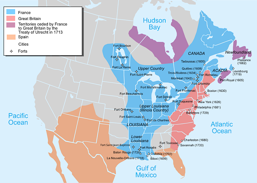
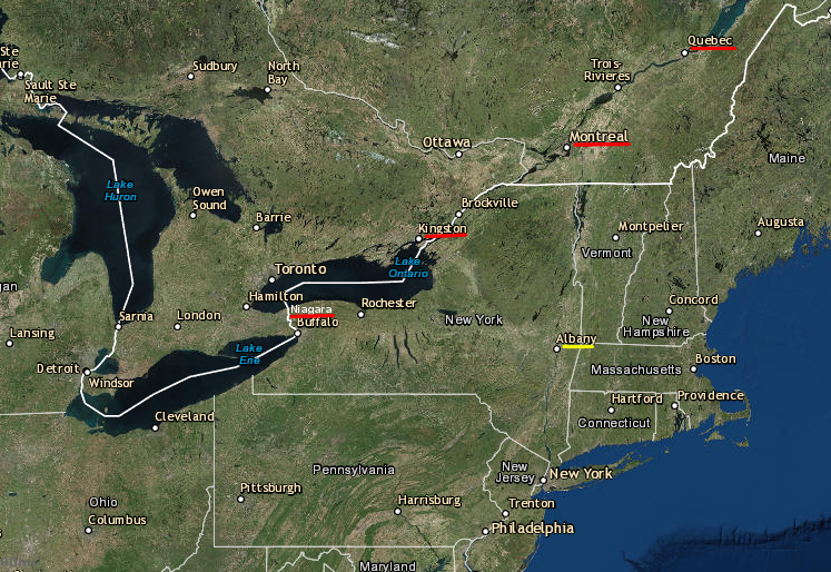
the English colonies competed with the French (and with each) for trade with different tribes
Source: ESRI, ArcGIS Online
Champlain's alliance with the Huron-Wendat started decades of French warfare with the Mohawk and four other Iroquoian-speaking tribes. After Jacques Cartier and Jean-Francois Roberval had tried to start French colonies in the St. Lawrence River valley in the 1540's, the Mohawk, Oneida, Onondaga, Cayuga, and Seneca living south of the St. Lawrence River formed an alliance. The five tribes created the Haudenosaunee confederacy, also known as the Iroquois League or the Five Nations.
After the creation of the Haudenosaunee confederacy, negotiations over council fires replaced most warfare between those five nations. Inter-tribal conflict resolution, based on honoring the dead through condolence ceremonies rather than revenge attacks, largely replaced the population-draining blood feuds among the five tribes. By cooperating rather than fighting each other, the Iroquois were able to focus on attacking their neighbors and force them into subordinate status. The Iroquois expanded their control over the territory west of the Hudson River and south of the St. Lawrence River, ultimately claiming in treaties with the English that they controlled land down to the Ohio River.
The stimulus for Iroquois dominance was not a desire to acquire farmland, proselytize religious views, or impose the political system of the Haudenosaunee on other Native Americans. The Iroquois sought to gain/maintain control over the trade for deer skins and other furs with the Europeans. The Europeans supplied the guns that enabled the Iroquois to dominate rivals armed with just bows, arrows, spears and clubs.
Furs could be exchanged for guns, ammunition, and gunpowder that was available only from the Europeans; the Native Americans in eastern North America did not melt iron ore and manufacture metal products. The primary French trading stations were on the St. Lawrence, and the primary Dutch/English trading stations were on the Hudson River.
The beaver and other animals were over-hunted in the nearby valleys of the St. Lawrence, Hudson, Mohawk, Susquehanna, and Delaware rivers, so Native American tribes living near the trading stations sought to expand their territory and acquire control over new hunting grounds. Guns acquired by trading furs facilitated conquest of new land to the north, west, and south of Montreal and Albany.
Guns also enabled tribes living near the trading stations to block rivals from bringing furs directly to the Europeans. The Iroquois imposed the equivalent of a tax for passing through their lands, or required more-distant tribes to sell at a below-market price to the Iroquois.
At times the Europeans cooperated in maintaining Native American monopolies, and at times they sought to break monopolies that had been established. To establish direct access to furs coming from the west, the French and English built forts deeper and deeper in the backcountry.
The forts were intended to bypass various Native American groups that served as intermediaries, as well as establish claims by different European nations to different territory. Fighting over that trade triggered multiple realignments of Native American nations prior to the start of the French and Indian War in the 1750's.2
Champlain may not have understood clearly the relative strength of the different tribes, but he did understand topography and hydrography. The Huron-Wendat lived close to the French settlements. The network of rivers on the north side of the St. Lawrence made it easier to obtain furs from inland sources which the Huron-Wendat appeared to control, and the French preferred the quality of the furs coming from the colder north. That shaped his decision to fight the Iroquois, rather than to try to establish an alliance with them.
The French alliance with the Huron-Wendat started almost a century of French warfare with the Iroquois, especially the Mohawk who lived on the eastern edge next to the Hudson River.
The Dutch established Fort Nassau in 1614 and Fort Orange on the Hudson River in 1624. Those bases offered the Iroquois easy access to European weapons, in exchange for furs.
The Dutch and French competed for the Native American trade for nearly 50 years. When the English seized Fort Orange and renamed it Albany, they continued the competition. At the same time, Native American groups fought each other to control the fur trade with the French at Montreal and the Dutch/English at Albany.
To compete with Fort Orange, the French sought to place a trading fort closer to the furs coming from the Great Lakes and Hudson Bay watersheds. Montreal was settled in 1642, further up the St. Lawrence River from Quebec, and quickly became the place for Native Americans to exchange furs for guns, clothing, and other trade goods.
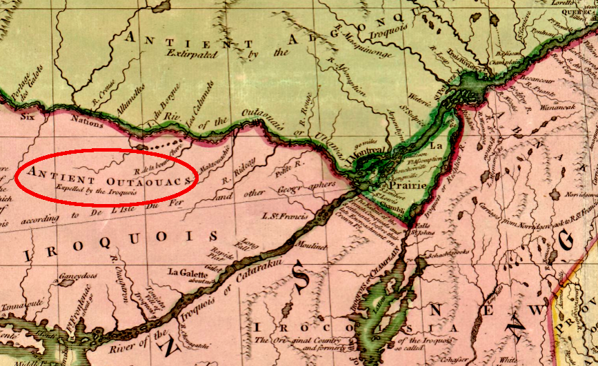
the Iroquois defeated the Outaouacs (Ottawas) and other tribes north of the St. Lawrence River in the 1649-51 Beaver Wars, taking control of the territory where furs could be acquired for sale to the French in Montreal and the Dutch at Albany
Source: Library of Congress, A map of the British and French dominions in North America (John Mitchell, 1755)
The five Haudenosaunee nations won the first "beaver wars" in 1649-51, coincidentally after European nations had signed two treaties known as the Peace of Westphalia to end decades of conflict.
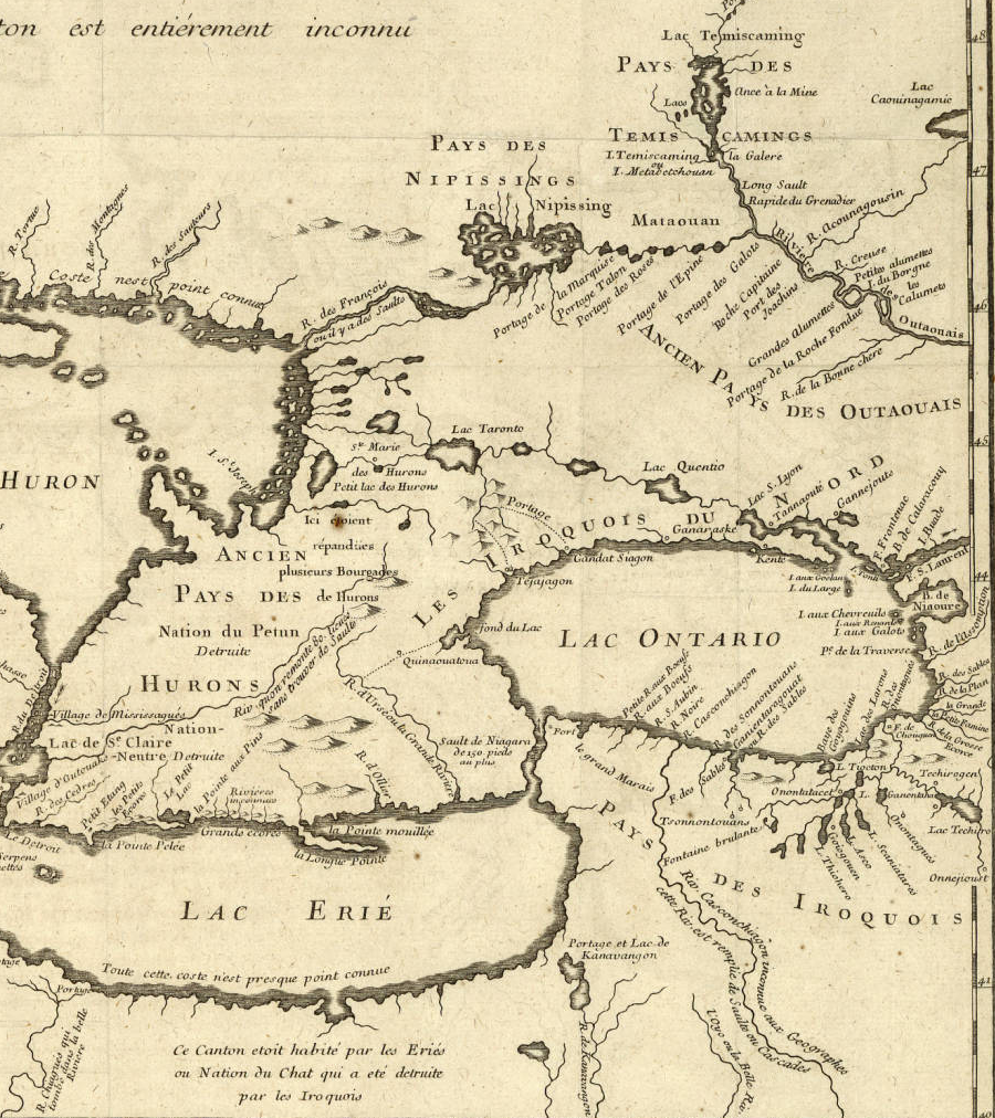
In the beaver wars, the Iroquois defeated rivals who lived north of the St. Lawrence River and Lake Ontario. They destroyed villages and dispersed the populations of the Huron-Wendat, Neutrals, Nipissing, and Petun. The victories gave the Iroquois much greater control over furs coming from the northwest to the French at Montreal and to the Dutch at Fort Orange.
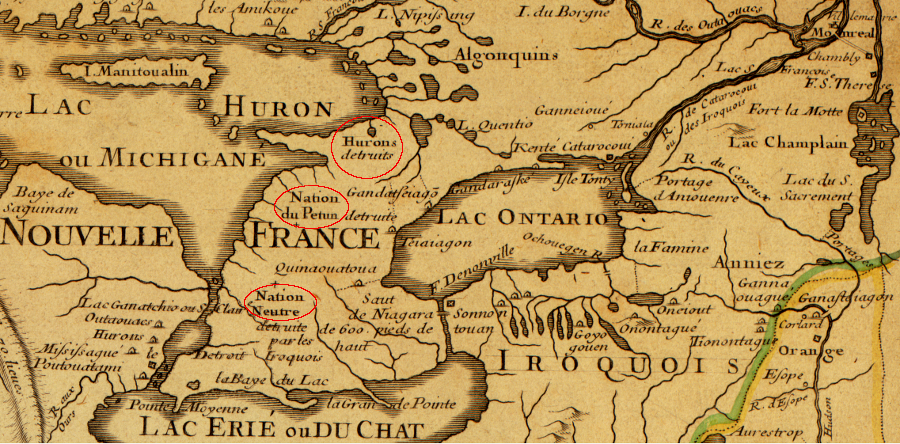
a French cartographer recorded in 1718 that the Huron, Petun, and Neutral nations had been destroyed ("detruite") by the Iroquois
Source: Library of Congress, Carte de la Louisiane et du cours du Mississippi (1718)
After success in the beaver wars, the Haudenosaunee could have made a concerted effort to expel the French. The colonists in New France were poorly supplied and lacked the resources to sustain a long-term conflict. To the south the Dutch were supplying guns to the five nations. A series of raids by the Iroquois threatened to force the French to abandon their colonial settlements in the St. Lawrence River valley.3
the Iroquois defeated the Outaouacs (Ottawas) and other tribes north of the St. Lawrence River in the 1649-51 Beaver Wars, taking control of the territory where furs could be acquired for sale to the French in Montreal and the Dutch at Albany
Source: Library of Congress, A map of the British and French dominions in North America (John Mitchell, 1755)
Garacontie, chief of the Onondaga, ensured the survival of New France when he brokered an Iroquois-French peace in 1654. Garacontie desired to preserve France's St. Lawrence River trading posts on the north, knowing that competition between Europeans would benefit the Iroquois.
The Iroquois had access to English and Dutch traders on the Hudson River and to English traders further south in Maryland and Virginia. Garacontie desired to preserve France's St. Lawrence River posts to provide competition. Even when the French goods were lower quality and more expensive, the Iroquois recognized that perpetuating European rivalries in North America would provide long-term benefits to the Native Americans.
The 1654 peace deal also defined Garacontie's own Onondaga as the dominant nation in the Haudenosaunee Confederacy, even though the Mohawk were located closest to the Dutch trading post. The other four nations had been frustrated by Mohawk control over access to European trade. The Mohawk controlled the "eastern door" of the confederacy at Fort Orange, located at the mouth of the Mohawk River at what would become Albany, New York.
Other nations had to pay taxes to the Mohawks in order to trade at Fort Orange. After the 1654 peace with the French, the Oneida, Onondaga, Cayuga, and Seneca nations in the Haudenosaunee Confederacy could bypass the Mohawk and the Dutch traders and do business directly with French traders in Montreal.
The unlicensed courier du bois, often children of French men and Native American women who could speak different languages and adapt to different cultural situations, facilitated trade in the backcountry. They too tried to bypass the Native American middlemen.4
The 1654 peace with the French reduced the power of the Mohawk nation. Mohawk warriors often sought to create incidents that would re-ignite warfare and block trade with the French. Limiting trade with Montreal would re-establish Mohawk dominance of trade for European goods.
Ambitious young warriors in the Seneca, Oneida, Cayuga, and Onondaga tribe often allied with the Mohawk, choosing the honor of a fight over the benefits of peaceful trade with the French. Continued seizure of goods from traders and fighting in the backcountry, despite Garacontie's 1754 peace, left New France struggling to survive.
King Louis XIV solved that problem. In 1663, the young French king cancelled the monopoly of the Company of One Hundred Associates and made New France into a royal colony. New France had not demonstrated economic viability, but in 1665 Louis XIV deepened his commitment by sending the Carignan-Salieres regiment to Quebec. The French troops moved south and invaded Mohawk territory, destroying villages in a 1666 raid. That attack successfully rebalanced power between the French and Haudenosaunee.
The cultural integrity and military/economic power of the Mohawk declined over the next 30 years. Many chose to convert to Catholicism and moved north to live in the Montreal area, creating a barrier to attack and reducing the threat to New France from the "eastern door" of the Haudenosaunee Confederacy. The modern Kahnawake reserve, near the Lachine Rapids south of the city, is the center of the Mohawk community still living there after 300 years.
After the peace deal with Garacontie in 1654, French officials looked west to increase their control of trade. They sought to manage the flow of goods, and to conflicts between traders and different groups of Native Americans, by setting up a series of backcountry posts that ultimately stretched inland from Montreal past the Great Lakes and down the Mississippi River.
The French continued that pattern to the southwest of Montreal in the 1740's, seeking to open trading posts in the Ohio River valley. That initiative led to the French and Indian War in the 1750's, when the Virginians sought to settle the same area and resisted French expansion. South of Virginia, the English, French, and Spanish created rival trade alliances with various North American tribes to control the deerskin trade.
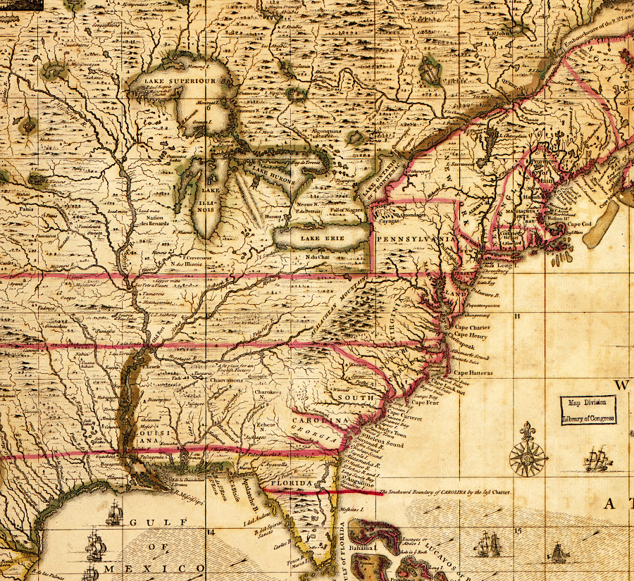
the French claimed the Ohio River Valley was part of Louisiana and initially defined the Susquehanna River as the western edge of Pennsylvania
Source: Library of Congress, A Map of Louisiana and of the River Mississippi (from the New General Atlas, 1721, map by John Senex, 1740)
The French effort to open trading posts in the Ohio River, which led to the French and Indian War in the 1750's, was simply a continuation of a pattern established 150 years earlier. The French and Indian War was just the final phase of a European struggle to control trade and territory in the region between the Chesapeake Bay and the St. Lawrence River, and in the backcountry of the Carolinas and Georgia.
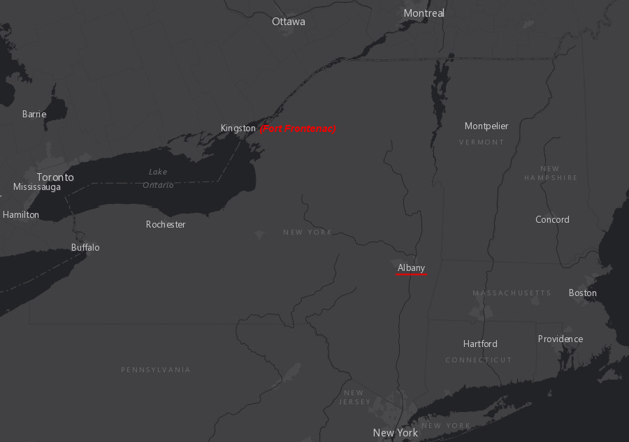
the French built Fort Frontenac in 1673 to intercept Native American traders before they reached Albany and did business with the rival Dutch/English there
Source: ESRI, ArcGIS Online
The Dutch were also involved in the prelude to the French and Indian War. As the French were colonizing the St. Lawrence River valley, the Dutch had focused on the Hudson River to the south. They started trading there soon after Henry Hudson first examined the river in 1609.
Dutch traders sailed north to the mouth of the Mohawk River to trade. They bought furs from both the Algonquian-speaking Mahican who lived there and their neighbors/rivals, the Iroquoian-speaking Mohawk. When the two tribes created too much trouble by fighting with each other, the Dutch purchased the island of Manhattan at the mouth of the Hudson River to provide a reliable site for doing business.
The Dutch and French competed for the Native American trade for 50 years, until the English displaced the Dutch and took full control over New York. The English-French competition continued for another century. On the other side of the business dealings, Native American groups competed with each other to benefit from the fur trade with the French on the St. Lawrence River and the Dutch/English on the Hudson River.
The Dutch built Fort Nassau at the mouth of the Mohawk River in 1614, and replaced it with Fort Orange in 1624. Those Dutch forts offered the Iroquois easy access to European weapons in exchange for furs, without having to travel north through territory initially controlled by Huron-Wendat to reach French trading stations.
The Mohawk in particular took advantage of their location to do business with both French and Dutch traders, depending upon the purchase price offered for furs and the sale price charged for European goods by European competitors. The Iroquois could also seek trade goods from further south. Intermediaries such as the Delaware provided access to Swedish forts on the Delaware River, and the Susquehannock did business with English traders at Kent Island in the upper Chesapeake Bay.
The construction of permanent Fort Orange in 1624 led to a final disruption of the Mohawk/Mahican balance. The local fur supply was exhausted, but the Mohawk refused to allow the Mahican to acquire furs from other tribes to the west and north. By 1628, after several military victories, the Mohawk forced the last of the Mahican to move east of the Hudson River. After that, the Mohawk largely controlled access to Fort Orange (and then Albany) at the mouth of the Mohawk River for 125 years.
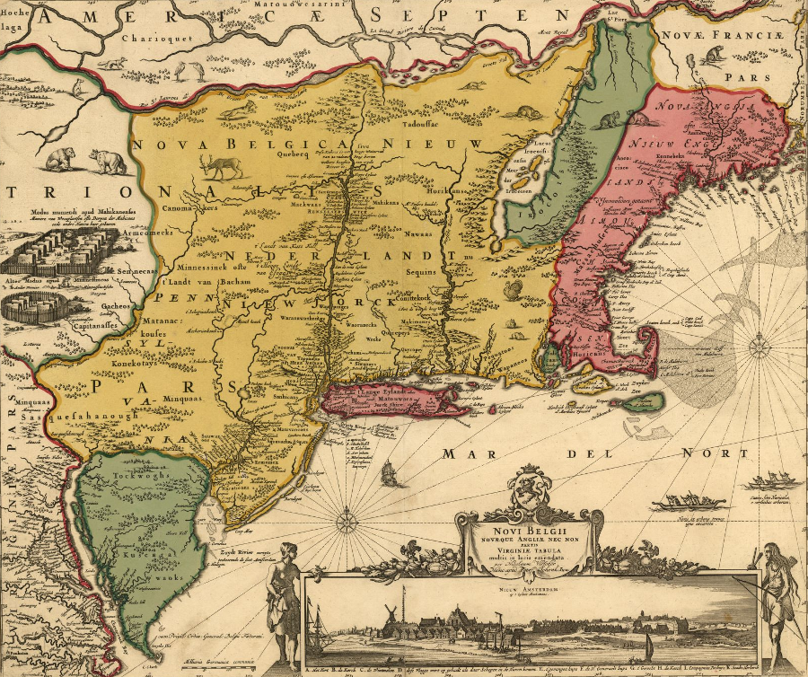
the Dutch claim to New Amsterdam extended north to the St. Lawrence River, and included the Hudson River valley explored by Henry Hudson in 1609
Source: Library of Congress, Novi Belgii Novaeque Angliae: nec non partis Virginiae tabula multis in locis emendat (1685)
After defeating the Mahican on the east by 1628, the Mohawk and their Haudenosaunee Confederacy allies expanded to the north as well. That expansion was facilitated by the English, who took temporary control of Quebec between 1629-1632.
During that short window, the French could not supply their Huron-Wendat allies and the Iroquois gained control of much of the St. Lawrence River valley. The Haudenosaunee and savvy leaders of other Native American nations took advantage of the rivalries between nations in Europe to acquire European-manufactured guns, to expand control over North American territory that supplied furs, and to dominate trade with those Europeans.5
In 1664, the rivalry between the France and England in the St. Lawrence River watershed was altered when James, brother of Charles II, gained control of Albany and the Province of New York. The English seized the Dutch trading post at the mouth of the Mohawk River in 1664 during the Anglo-Dutch wars, though the Dutch briefly regained their settlement. After the Anglo-Dutch wars ended in 1674, New Amsterdam was renamed New York, Albany became an English trading post, and the Dutch withdrew from North America.
French settlements west of Quebec were located where they could intercept furs being carried to the competing trading fort at Albany
Source: ESRI, ArcGIS Online
The expansion of English power into the interior of New York concerned the French based in Montreal. To intercept Native Americans who might bring western furs to trade with the English, the French established Fort Frontenac on Lake Ontario at Cataracoui (now Kingston, Ontario) in 1673. In 1679 the French also built a trading post at Niagara, directly on the trading path of the Seneca nation.
The leaders of the Haudenosaunee Confederacy were reluctant to permit those French intrusions deep into their territory; the peace negotiated by Garacontie over 30 years earlier in 1654 was placed at risk by the French expansion. Forts/trading posts west of Montreal could undercut the Onondaga trading relationship with the Ottawa to the north and with other tribes.
However, the French presence on Lake Ontario might provide some protection for the far-western Seneca against the Susquehannocks, and prices at Fort Frontenac were 100% higher than Albany prices. The inability of the French to compete on price or quality with the English traders left the Iroquois plenty of opportunity to make a profit, no matter where the French engaged in trade.6
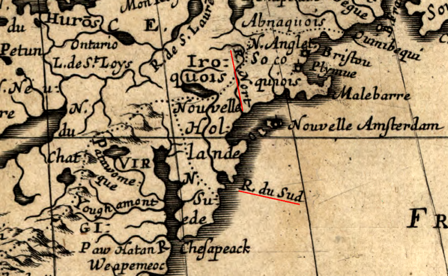
after defeat of the Dutch, the New York colony claimed all the land between the North (Hudson) River and South or "R. du Sud" (Delaware) River
Map Source: Library of Congress, Amerique septentrionale
For the Native Americans, the disappearance of the Dutch (and the previous loss of Sweden in 1655, when the Dutch seized New Sweden) meant the loss of a supplier. Reduced competition reduced leverage to bargain for weapons and gunpowder from rival Europeans. Reduced competition reduced leverage to bargain for weapons and gunpowder from rival Europeans - but the competition between the French and English continued until the 1760's.
For the next century, the Native Americans north of Virginia skillfully took advantage of the competition between the French and English. Near the Spanish territory of Florida, the Creek, Cherokee, Chickasaw, and other tribes bargained with English in the Carolina and Georgia colonies, the French near New Orleans, and the Spanish at Pensacola and St. Augustine.

in 1645, the French, English, and Spanish colonies in North America were separated from each other
Source: Banque d'images en univers social, Carte de la Nouvelle-France vers 1645
In 1676, King Philip's War erupted in New England. In that conflict the Mohawk chose to ally with the English rather than with the Pequot nation, and used the opportunity to eliminate rival Native American groups in the Connecticut River valley. Also in 1676, the Haudenosaunee Confederacy established a long-term "Covenant Chain" of peace and friendship with the English. That peace was so advantageous that the alliance lasted until the outbreak of the French and Indian War, which caused the Mohawk to switch sides finally and ally with the French.
Over those 75 years, Iroquois warriors and their allies still harassed English settlers and traders. The colonists also created incidents with the Native Americans; theft and murder in the backcountry was not uncommon. To prevent incidents from growing into a widespread warfare that was not in the interest of either side, the links of the Covenant Chain of friendship were "brightened" (renewed) intermittently in conferences filled with ceremonies and promises. Maintaining the general peace, despite intermittent provocations, required Iroquois and the English to demonstrate both political skills and the military capacity to inflict significant damage on the other side.
The French displayed diplomatic skills equal to the English, in order to continue the peace first negotiated by Garacontie in 1654. French officials provided gifts on a regular basis to maintain positive relations with leaders of different Native American nations, splinter groups, and fragments of defeated tribes. Importing those goods via the St. Lawrence River and transporting them to Native American towns was expensive, but peace and trade was more profitable than war.
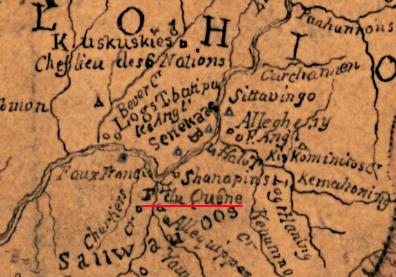
Colonial English officials were less reliable with their gifts, but often sold at better prices the guns, cloth, iron knives, and other items desired by the Iroquois and other tribes. For many Native Americans south of the St. Lawrence River, the English trading posts were closer until the French finally expanded into the Ohio River valley and finally built Fort Duquesne at the Forks of the Ohio River in 1753. The conflicts between European rivals then erupted into the French and Indian War, and the Native Americans chose sides.
The Native Americans were the most adept negotiators. The Iroquois successfully played the French against the Dutch and the English for 150 years in North America. The Covenant Chain created in 1676 meant the Iroquois were allied simultaneously with the English and the French, and both European countries were unlikely to attack.
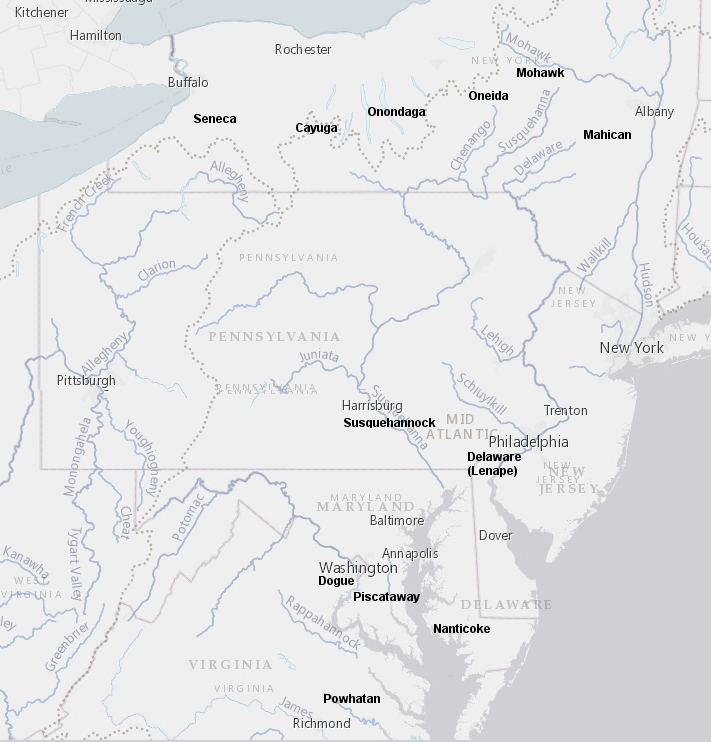
With both European sides neutralized, the Iroquois could focus their efforts on conquering the Susquehannock nation to the south. That Iroquoian-speaking tribe may have evolved from the same ancestral group as the Mohawk and Cayuga. The Susquehannock originally lived on the North Branch of the Susquehanna River north of modern-day Scranton, Pennsylvania. Sometime before 1570, they moved south to what later became Lancaster County, Pennsylvania.
The Susquehannocks started trading with the Dutch at Manhattan as early as 1626, and obtained plentiful supplies of weapons from different European competitors. For many decades, the Susquehannocks were a serious threat to the Mohawks at the "eastern door" of the Haudenosaunee Confederacy and even to the Seneca nation at the "western door."7
after the Europeans arrived, Native American nations sought to control access of their neighbors to furs and trade, disrupting the previous patterns of territory
Source: ESRI, ArcGIS Online
One brightening of the Covenant Chain was the Great Peace of 1701, after sporadic conflicts between French and Iroquois threatened to grow out of control. In that peace, the Mohawk and other members of the Five Nations (the Tuscarora did not join until the 1720's) agreed to stop fighting the French on their northern border.
This freed up the Iroquois to expand westward. They could pursue their goal of hegemony over the Shawnee and other tribes living in the Ohio River valley, and travel through Virginia to raid far south into Cherokee and Catawba country.
The French built Fort Detroit in 1701, extending their trading network further to the west. It was located on territory that Virginia had claimed since 1609, based its Second Charter which granted:8
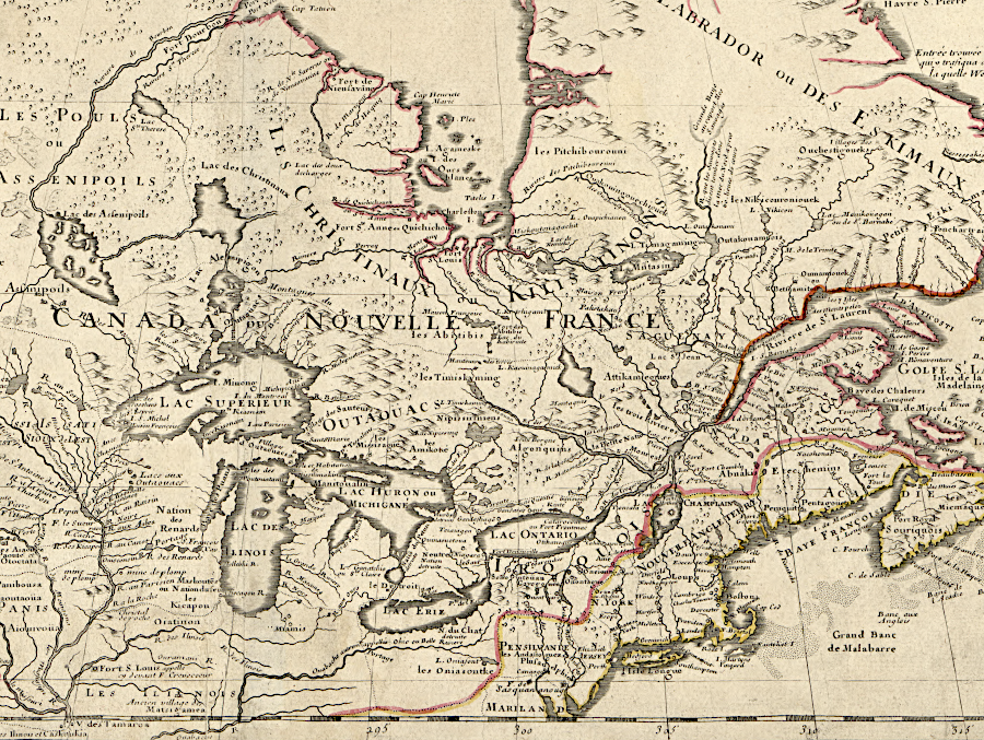
the French mapped west of Niagara Falls long before the British began exploring the Ohio River Valley
Source: Library of Congress, Carte du Canada ou de la Nouvelle France et des decouvertes qui y ont été faites (Guillaume De L'isle, 1718)
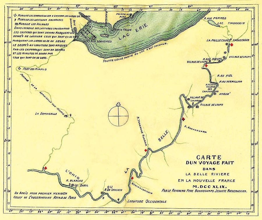
French and British traders sought allies along the Ohio River in the 1700's. In 1739, Baron de Longueuil took almost 450 men from Montreal to the site of modern Memphis, a 1,600 mile trip designed to suppress the Chickasaw on the Mississippi River. He boated up the St. Lawrence River, then across Lake Ontario and Lake Erie. The French military force crossed the Eastern Continental Divide via a portage in modern New York to Chautauqua Lake, then to the Belle Riviere (Ohio River).
At Big Bone Lick in modern Kentucky, Baron de Longueuil marked the site as a possession of the King of France. That is the earliest formal assertion by the French to their ownership of the Ohio River Valley.
in 1739, Baron de Longueuil took almost 450 men from Montreal via Lake Ontario and Lake Erie to the site of modern Memphis
Source: Wisconsin Historical Society, Carte des lacs du Canada (by Jacques Nicolas Bellin, 1744)
A decade later in 1749, the French sent Captain Pierre Joseph Celeron de Bienville and 250 soldiers down the Ohio River. They buried six lead plates on the Allegheny and Ohio rivers to assert French ownership of the territory, and directed all the British traders they encountered - including some at the Forks of the Ohio - to leave. The French and the Seneca considered the start of the Allegheny River to be the headwaters of the Ohio River (La Belle Riviere), rather than placing the headwaters at the confluence of the Allegheny and Monongahela rivers (Forks of the Ohio).
A seventh lead plate, 7.5" by 11" in size, was stolen by the Seneca from the French at the Niagara fort before the trip down the Ohio River began. It was delivered to William Johnson, the agent for the New York colony with primary responsibility for dealing with the Iroquois, on December 4, 1750. Other plates have been found and excavated. The lead plate buried at the mouth of the Kanawha River (called "Chinodahichiltha" when the French visited in 1749) is in the collection of the Virginia Museum of History and Culture.
in 1749, Captain Pierre Joseph Celeron de Bienville buried six lead plates on the Ohio River to assert French ownership of the watershed
Source: Wikipedia, Pierre Joseph Céloron de Blainville
The French pre-stamped the message on the plates in Montreal, leaving just a space for Celeron de Bienville to inscribe the location where each would be buried. The inscription on the plate owned by the Virginia Museum of History and Culture says (in French):9
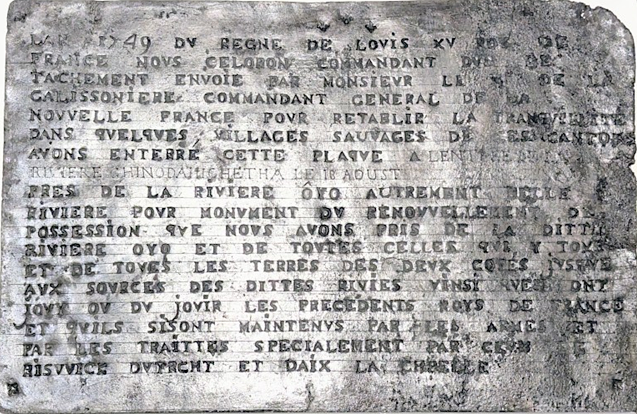
Celeron plate plate owned by the Virginia Museum of History and Culture
Source: Virginia Museum of History and Culture, Pierre Joseph Céloron de Blainville (as published in Cardinal News January 13, 2026)
Francis Parkman, in the florid language he used in 1870, wrote that the French were filling up the empty space between the Mississippi and Ohio rivers:10
French troops went down the Ohio River in 1739 and 1749
Source: 1740's Pennsylvania Maps, A Map of the French Settlements in North America (by Thomas Kitchen, 1747)
Pierre Chartier started a trading post at the Forks of the Ohio in 1734. He traded with local tribes, and with Miami and Shawnee that traveled east from what is now Indiana. Chartier sent skins/furs to Quebec or to British towns such as Albany. Though he was the son of a French trader, he sold to the British when they offered a better price.
The 1749 French expedition by Celeron de Bienville triggered a response from the Ohio Company. It sent Christopher Gist to map the Ohio River. He traveled from the Forks of the Ohio to the Scioto River during the winter of 1750-51. Working with Delaware Chief Nemacolin, they laid out what became known as Nemacolin's Trail west from Cumberland, Maryland to the Monongahela River at the mouth of Redstone Creek.11
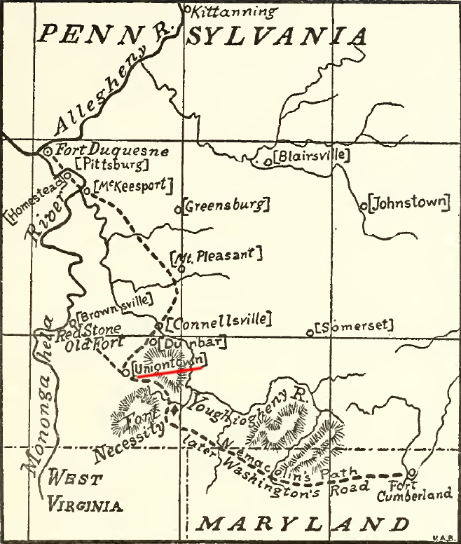
the Nemacolin Trail continued from modern Uniontown to the Monongahela River, diverging from the old path coming south from the Foks of the Ohio
Source: Archer Butler Hulbert, Washington's Road (Nemacolin's Path) the first chapter of the old French war (p.93)
The British claim to the Ohio River watershed was based on the Virginia charter and also an assertion that the English had "conquered" the region. No English troops had reached the Ohio River, but the Iroquois acceptance of the Treaty of Lancaster in 1744 was defined as a sufficient proof of British conquest.
In 1753 the French started to build four forts to control the Venango Path between Lake Erie and the Ohio River. Fort Presque Isle was built on the southern shore of Lake Erie. Fort Duquesne was located at the headwaters of the Ohio River where the Allegheny and Monongahela rivers met. Fort Machault and Fort LeBoeuf protected the waterways between them.
As described by a historian at the Virginia Museum of History and Culture:12
the French built Fort Duquesne on the edge of the English claim to the Pennsylvania colony, on land also claimed by Virginia
Source: Library of Congress, Map showing French occupation of the Ohio Valley: taken from Mr. Robert's Atlas universel (1755)
Gov. Dinwiddie sent George Washington to Fort LeBoeuf with instructions to direct the French to leave the territory claimed by the British. Dinwiddie's letter to the French commander started with a bold claim:13
Washington was treated with courtesy when he arrived at Fort Le Boeuf; the French and English had been at peace since 1748. The commander, Legardeur De St. Piere, provided a direct response to Dinwiddie's demand:14
Native Americans living in the Ohio River watershed did not think the claims of any of the colonists to their lands were valid. The Iroquois, Shawnee, Delaware, Mingo, and other tribes were unwilling to be displaced no matter what philosophical theories might be developed in Europe to justify seizing the already-occupied lands in North America.
Tanaghrisson, the "Half King" appointed by the Iroquois to oversee Native Americans in the Ohio River Valley over which the Iroquois claimed control, told a French captain in 1753:15
Tanaghrisson saw the French as the greater threat. He recognized that staying neutral would not protect Native American control of their townsites, fields, and hunting grounds. He chose to ally with the British, gambling that he could retain more control if he supported the winning side in a war in the backcountry.
Washington returned with a military force in 1754 to protect the Ohio Company workers who were constructing Fort Prince George at the Fors of the Ohio. While Washington was leading the advance force of the Virginia Regiment to the fort, the French forced the Ohio Company to leave and started to build Fort Duquesne.
Tanaghrisson then guided the Virginians so they could attack a group of French who were asleep in a glen, ensuring the European powers would start to fight. Tanaghrisson calculated that if his strategy was successful, he would end up with space on the Ohio River that would be protected by British allies.
George Washington triggered the start of the French and Indian War when he and his men attacked the French detachment that was sleeping in Jumonville Glen. In the French description of the incident, the Virginians assassinated an ambassador coming to talk with Washington.
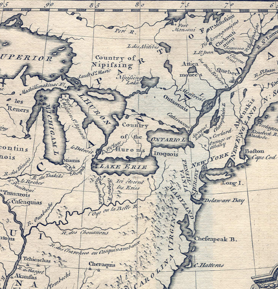
at the start of the 18th Century, France and Spain laid claim to almost all of North America
Source: Library of Congress, Tabula Mexicae et Floridae: terrarum Anglicarum, et anteriorum Americae insularum, item cursuum et circuituum fluminis Mississipi dicti. (by Peter Schenk, 1710?)
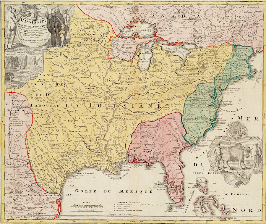
not surprisingly, France claimed Louisiana and assigned far less territory to Spain in the Mississippi Valley
Source: Boston Public Library, Norman B. Leventhal Map & Education Center, Amplissimae regionis Mississipi seu provinciae Ludovicianae â R.P. Ludovico Hennepin Francisc. Miss. in America septentrionali anno 168 (1720?)
English mapmakers asserted their claim of control over western lands, to the Mississippi River
Source: Library of Congress, A map of the British Empire in America with the French and Spanish settlements adjacent thereto (Henry Popple, 1733)
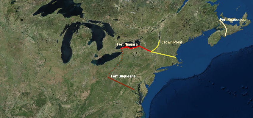
the English planned to seize four major forts in the 1755 campaign, isolating Quebec and Montreal
Source: ESRI, ArcGIS Online
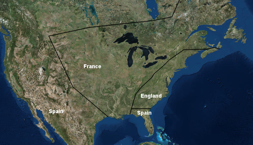
a rough approximation of French and Spanish claims in North America after the 1713 Treaty of Utrecht shows the English colonies restricted to the Atlantic Ocean coastline
Source: ESRI, ArcGIS Online