Failure of the French Before Jamestown
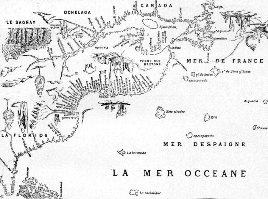
maps documenting early French exploration treated the southeastern corner of the North American continent as Spanish territory ("La Floride"), but asserted French claims to the St. Lawrence River valley
Source: Canada: the Empire of the North, Dauphin Map of Canada (by Jacques Cartier, c.1543)
The French claim to lands in North America was based on the Doctrine of Discovery, a European concept that allowed France to assert legal ownership of lands not occupied by Christians. The first French to reach North America were interested in fish, not furs or land.
The territory that became New France and later Canada was "discovered" by French fishermen starting in 1504. Catholics in France avoided meat for almost 40% of the year, and the Grand Banks in the North Atlantic offered an alternative to fishing in crowded waters near Scandinavia. Thomas Aubert alerted fishermen in Normandy about the rich source of cod in the fishing grounds off New Found Land in 1508.1
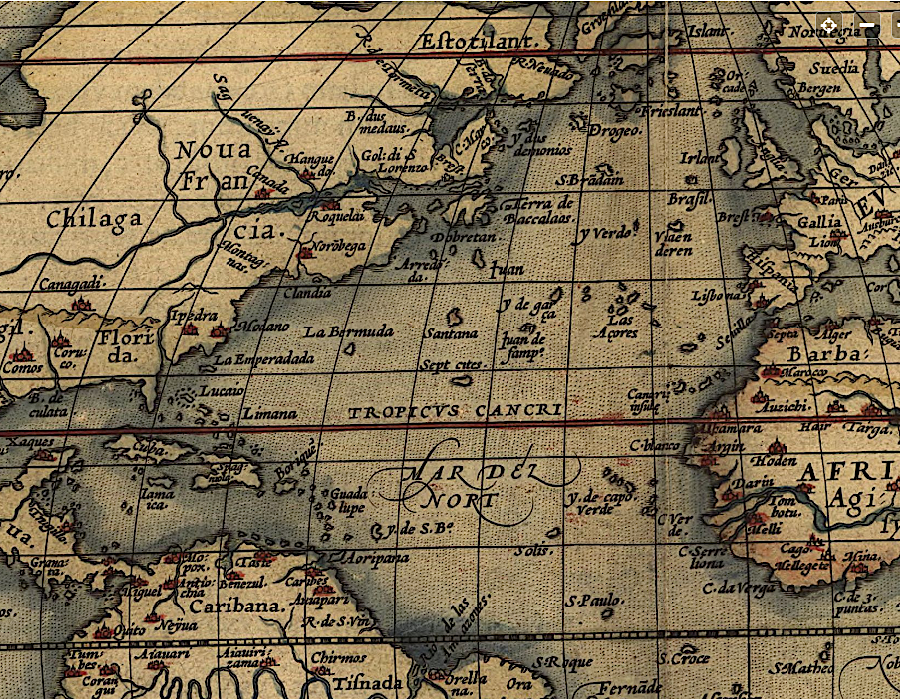
French King Francis I financed explorations by Giovanni da Verrazzano to explore the coast of North America in 1524. To minimize the chance of creating a justification for military action, that expedition explored far north of the Spanish-controlled Caribbean. Verrazzano chose to stay rather far from the shore and missed the mouth of both the Chesapeake Bay and Delaware Bay. He did discover New York harbor, where the Verrazano Bridge (missing one "z") was named for him.
On the way north up the coastline, Verrazzano stopped at what may have been Cape Fear, Hatteras, and the Eastern Shore of Virginia/Maryland. He had the political good sense to name the land "Francesca" to honor his French king, Francis I. After Verrazzano saw water behind barrier islands, he was one of many who explored eastern North America and claimed to glimpse the Pacific Ocean:2
- We called it Annunciata from the day of arrival, and found there an isthmus one mile wide and about 200 miles long, in which we could see the eastern sea from the ship... This is doubtless the one which goes around the tip of India, China and Cathay.
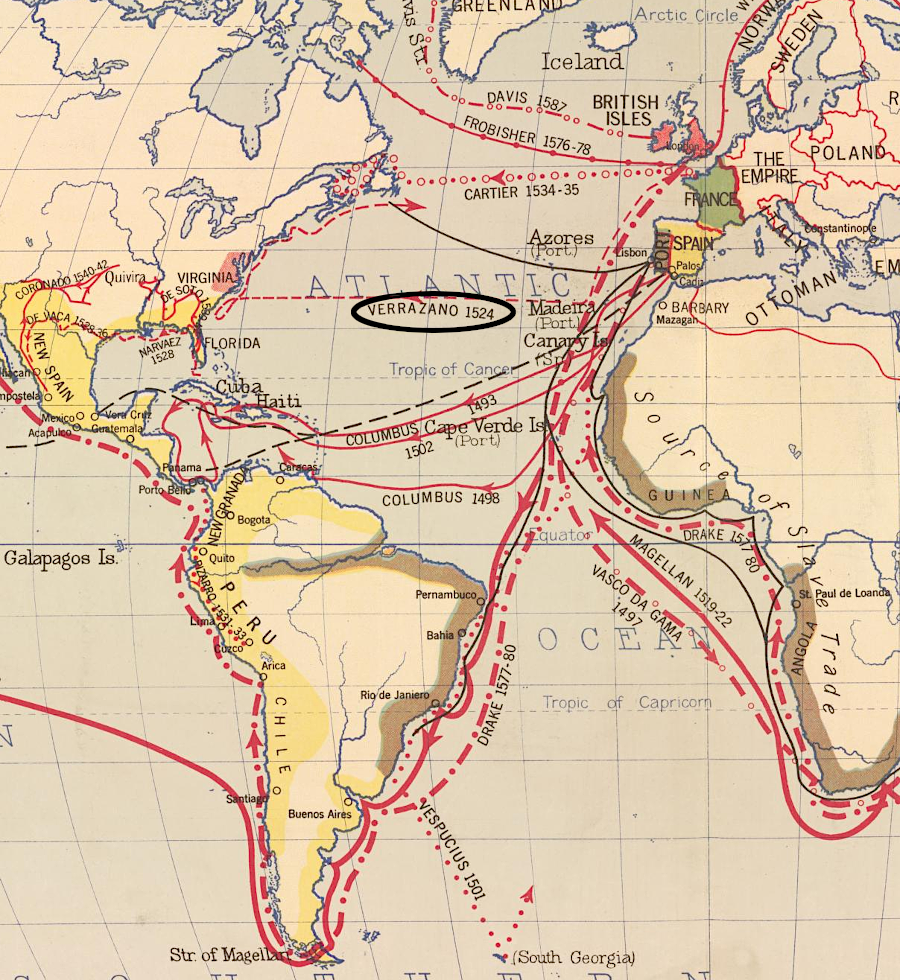
in 1524, Giovanni da Verrazzano sailed along the Atlantic Ocean shoreline of what later became the English colony of Virginia
Source: Library of Congress, World exploration to 1580 (Image 2, Hart-Bolton American history maps, 1917)
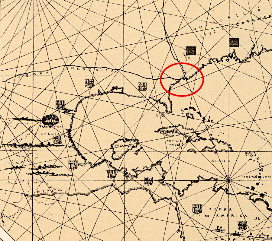
Verrazzano thought he saw the Pacific Ocean west of the Outer Banks, and that there was a narrow isthmus in North American similar to Panama
Source: David Rumsey Historical Map Collection, Plate 13 Facsimile Cartography 1492-1867. Verrazano Map, 1529
The French knew that Spanish settlement was focused on the major islands in the Caribbean, plus New Spain (Mexico) and the western side of South America (Peru). Starting in the 1530's, the French explored far to the north of the Spanish in the St. Lawrence River Valley, expanding their activities in the New World beyond fishing.
Jacques Cartier led three expeditions starting in 1534. His initial goal was to discover a passage to Asia.
In the Gulf of the St. Lawrence, he encountered people fishing who had come from the town of Stadacona (at the future site of the city of Quebec). Cartier took two sons of the local chief, Donnacona, back to France. They revealed the existence of the St. Lawrence River and its flow from the west.
Cartier returned the two sons when he sailed directly to Stadacona in 1535. He discovered that the people of Stadacona opposed his efforts to sail further upstream to trade with the Iroquois at Hochelaga (modern Montreal). From the very beginning of European contact, tribes along the Atlantic Ocean shoreline fought to control contact of inland tribes with the French, English, and Dutch. Cartier sailed to Hochelaga, and he also angered the local residents by building a fort at the mouth of the Sainte-Croix River (now known as the Saint-Charles River).
King Francis I in Paris sponsored Cartier's major expedition with 10 ships in 1541, consciously intending to establish a permanent colony. On what was his third trip, Jacques Cartier sailed upstream to visit Hochelaga again. He discovered that the Lachine rapids in the St. Lawrence River blocked ships from going further upstream; there was no Northwest Passage up the St. Lawrence River to the Pacific Ocean.
On his second trip in 1535, Cartier had started a settlement that he named at St. Croix. It was located across the St. Lawrence River from Stadacona. In 1541 he built Fort Charlesbourg-Royal and planted 350 colonists at the mouth of the Rivière du Cap-Rouge. That site was on the north side of the St. Lawrence River, just upstream of Stadacona.
Another 200 French colonists arrived in 1542 with the commander of the third expedition, Jean-François de la Rocque, Sieur de Roberval. He brought with him prisoners that had been released from jail in exchange for joining the expedition. They were not by nature obedient to his orders, and since he was a Protestant his authority over Catholics was also diminished. Roberval had to quash multiple attempted mutinies.
Cartier ignored orders from Roberval to join him. Cartier and the colonists who had survived the winter abandoned Charlesbourg-Royal and sailed back to France, hoping that the shiny rocks he had collected were gold and diamonds.
As was true for many mineral samples brought back to Europe in the 1500's and 1600's from North America, the rocks were common iron pyrite and mica/quartz. The phrase "as false as Canadian diamonds" became common after the value of Cartier's samples were determined.
Roberval reoccupied Charlesbourg-Royal and suffered through a cold winter. In 1543, he too abandoned the colonization effort and brought everyone back to France. The French burned the fort to prevent possible re-use by the Spanish. Further efforts to settle Canada were blocked by the religious wars between Catholics and Protestants in France.3
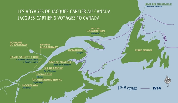
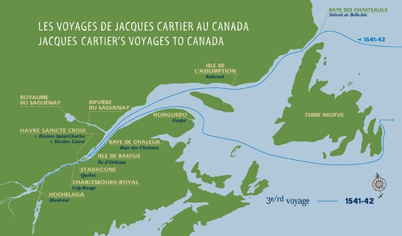
Jacques Cartier completed three trips to North America over 40 years before England tried to plant a colony there
Source: Cartier-Brébeuf National Historic Site, The second voyage (1535-1536); The third voyage (1541-1542)
the first attempt by the French to start a colony in North America was in 1541 at Fort Charlesbourg-Royal, near where Quebec was founded in 1608
Source: ESRI, ArcGIS Online
The next attempt to create a French colony in the New World focused on territory south of the Spanish colonies in the Caribbean.
Gaspard de Coligny, Admiral of France and leader of the French Protestants, sought to create a refuge for Huguenots on the opposite side of the Atlantic Ocean. He anticipated the religious wars that were about to erupt openly in France.
South America offered an opportunity because Portugal had failed to occupy all of the Brazilian coast. In 1555, Gaspard de Coligny tried to create a settlement at Guanabara Bay, now Rio de Janeiro. Poor leadership and internal tensions among the settlers caused most of them to return to France. In 1560, the Portuguese captured those who had remained at Guanabara Bay.
The French tried several more times to occupy a site in South America, but ultimately concentrated on North America.
They took advantage of the absence of any Spanish colonies on the Gulf Coast or the Mississippi River Valley. Phillip II of Spain had stopped further efforts to colonize North America in 1561. Tristan de Luna y Arellano's colony at Pensacola had failed, along with the plan to build an overland road to a Spanish base on the Atlantic Ocean coast at Punta de Santa Elena on the modern Florida-Georgia coastline.4
exploration of the St. Lawrence River led to the establishment of "New France" in North America
Source: Library of Congress, Theatrum orbis terrarum (by Abraham Ortelius, 1570)
In 1562, seven years after the failure at Guanabara Bay, Gaspard de Coligny sent Jean Ribault on an exploration of the southeast coast of North America. The Spanish had colonies on Caribbean islands and in Mexico (New Spain), but Florida was still unsettled. Establishing a colony much further south than the St. Lawrence River was risky. It would be closer to Hispaniola and the other islands in the Caribbean that had been colonized by Spain since 1493, but the climate and soil might be better.
Ribault explored what is now called the St. Johns River at Jacksonville, Florida. He made friends with the local Timucuan tribe and built a stone column to assert the French claim to the area on the southeastern edge of the North American continent.
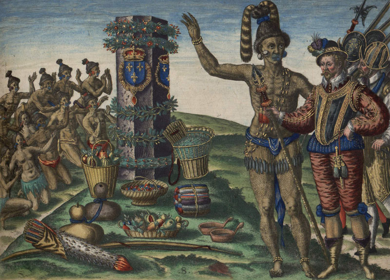
in 1562, the French built a stone column at what is now Jacksonville, Florida to assert their claim to land on the North American continent
Source: National Oceanic and Atmospheric Administration (NOAA), Historical Background Part I: French Colonization in Florida, 1562-1565
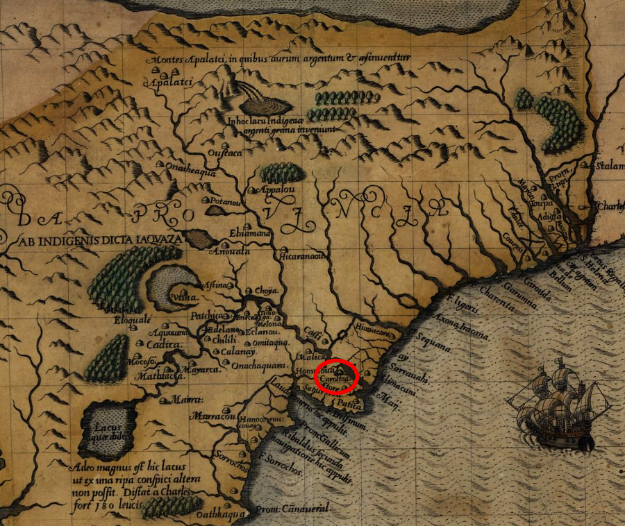
The French expedition in 1562 was an exploration trip. Ribault had not come with plans to start a colony, and he arrived without seeds, farming tools, or women. However, Ribault chose to leave 28 men at a place he named Charlesfort to initiate a settlement. Today, that site is part of the Marine Corps Recruit Depot on Parris Island in Beaufort, South Carolina.
Charlesfort was the second French attempt to establish a permanent colony in North America, after the 1541-43 failures on the St. Lawrence River. Ribault planned a quick return to France followed by re-supply of the colony. However, Catholic/Protestant warfare in Europe blocked his return to America.
Ribault was a Huguenot, a Protestant, while the French royal family was Catholic. The "Massacre of Vassy" occurred in 1562, the same year as Charlesfort was settled. Open warfare started in France between Protestants and Catholics. When Ribault gambled that he could get assistance from Queen Elizabeth in England, a fellow Protestant, he guessed wrong. He ended up in an English prison, rather than sailing back with supplies and reinforcements for his men at Charlesfort.
The settlers' life at Charlesfort was nasty, brutish, and short. The commander left by Ribault banished a soldier from the fort and left him to starve in a demonstration of military discipline, but that action backfired. The harsh punishment triggered a mutiny and the killing of the commander.
Recognizing that food would be inadequate for survival, the remaining colonists built a ship. Sailing back to France from Charlesfort was not something that anyone had anticipated, and the mutineers had to make sails from their clothing. One person chose to remain behind at Charlesfort when all the rest of the French left in 1563.
The trip home across the Atlantic Ocean turned out to be as challenging as living at Charlesfort. After running out of food on the ship, the returning settlers selected one person on the ship and killed him for food. The unfortunate one was the soldier who the commander had evicted from the fort and sentenced to starve. On the ship headed home, he ended up being eaten by his rescuers before they made contact with an English vessel near Ireland.
The Spanish discovered the location of Charlesfort after it had been abandoned. They seized the one Frenchman remaining in North America and burned the fort's wooden walls and structures.5
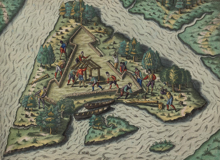
The French tried again after the 1562 Charlesfort settlement collapsed. In 1564 Rene Goulaine de Laudonniere led a three-ship expedition with 300 colonists back to North America. Rather than start again at Charlesfort, he chose to sail slightly further south. The French built Fort Caroline at the mouth of the St. Johns River, in what is now Jacksonville, Florida.
Fort Caroline (1564) was closer to the Spanish bases in the Caribbean than Charlesfort (1562)
Source: Library of Congress, Floridae Americae provinciae recens & exactissima descriptio auctore Iacobo le Moyne cui cognomen de Morgues (by Jacques Le Moyne de Morgues, published 1591)
Compared to Charlesfort, the site of Fort Caroline was better protected from hurricanes and offered fresh water. In addition, the Timucua Indians were friendly.
On the downside, Fort Caroline was even closer than Charlesfort to the Spanish-controlled islands of Cuba, Hispaniola, and Puerto Rico in the Caribbean. There were no Spanish settlements on the North American continent in 1564, but they were just several days away via the ocean. Spanish ships could sail up the St. John's River and blast the walls of Fort Caroline with cannons while landing soldiers for a ground attack.
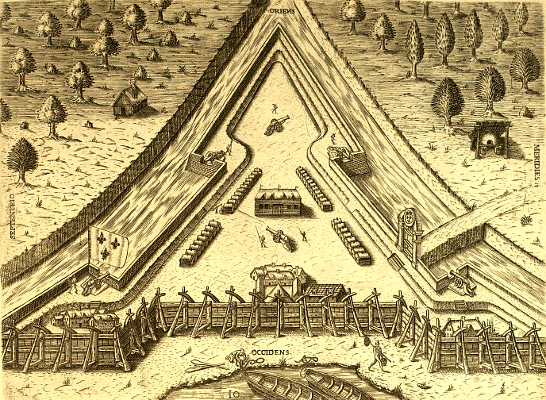
French colonists built Fort Caroline near modern-day Jacksonville (Florida) in 1564 - 43 years before the English built a similar triangular fort at Jamestown
Source: Exploring Florida, Le Moyne Gallery - Fort Caroline (Plate X)
Just as at Charlesfort, Fort Caroline was under-supplied. A faction mutinied, and de Laudonniere was forced to let them sail away with the food on a search for more supplies. An English fleet commanded by Sir John Hawkins arrived later, and the English provided food to the starving French in exchange for fresh water. The French also exchanged some of their cannons for one of the four English ships. They planned to sail home, and Fort Caroline was partially dismantled to reduce its value to the Spanish.
Just before the French colonists sailed away, a relief expedition under Jean Ribault arrived. Ribault had finally been released from an English prison, after which he had gathered 600 more soldiers and settlers and brought them to Fort Caroline in 1565. The one French settlement in North America was near the edge of starvation and in the process of abandoning its fort when a relief convoy arrived, just in time. That experience would be repeated later in 1610 by the English at Jamestown.6
the French established Charlesfort first in 1562 and then Fort Caroline in 1564
Source: University of Alabama, Historical Maps of the Southeast Region, Floridae Americae Provinciae
Ribault arrived just before a Spanish force led by Pedro Menendez de Aviles, who intended to destroy the colony of French Protestants. Menendez landed his soldiers on the coastline south of Fort Caroline. Ribault decided to attack the Spanish soldiers before they could build a fortified base. However, the weather did not cooperate. The French ships were caught in a storm and wrecked, with the soldiers and sailors ending up on a barrier island.
The Spanish immediately marched north despite the bad weather. They captured and destroyed the lightly-defended Fort Caroline, though de Laudonniere escaped. The Spanish found the shipwrecked French trapped on the island, nearly defenseless. Menendez had nearly all of them executed at what is now Fort Matanzas National Monument. Ribault's head was cut into four pieces.
Menendez established a permanent town at St. Augustine and with a piece of Ribault's head nailed to a post on the edge of the town.7
Fort Caroline was constructed in classic European style in 1564, but the Spanish under Pedro Menendez de Aviles captured it in 1565
Source: National Oceanic and Atmospheric Administration (NOAA), Historical Background Part I: French Colonization in Florida, 1562-1565
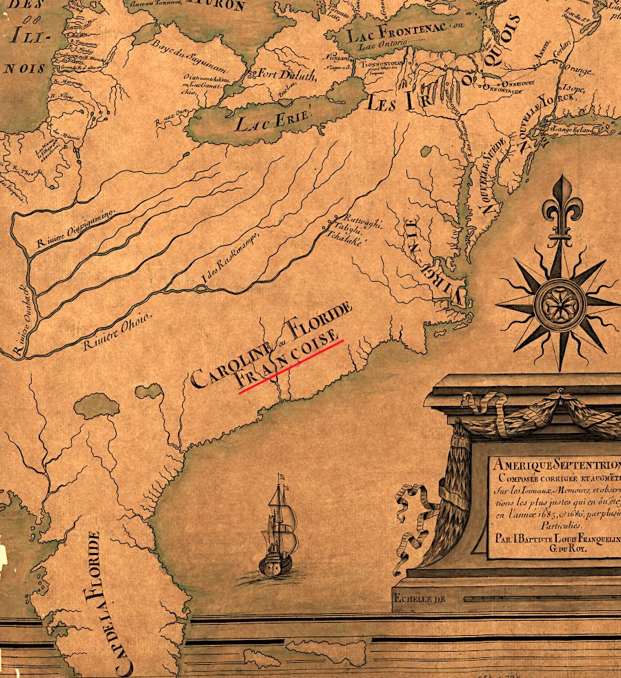
as late as 1685 the French were still asserting a claim to the Carolina coast
Map Source: Library of Congress, Amérique septentrion.lle [i.e. septentrionale] (by Jean Baptiste Louis Franquelin, 1685)
Lack of supplies, resistance by the local Native Americans, and direct attack by the Spanish quickly ended French attempts to settle on the southeastern coastline of North America. After failing at Charlesfort (1562) and Fort Caroline (1564), the French chose to settle again in Canada. The 1541 colony started by Jacques Cartier on the St. Lawrence River had lasted only two years, but intermittent fur trading had been profitable since then.
Charlesfort and Fort Caroline provided a clear lesson to French and English settlers: the threat of Spanish attack was very, very real. That lesson shaped the location of colonial settlements attempted by both France and England. Both chose to create colonies north of Cape Hatteras, north of where Spanish ships turned east to follow the trade winds back to Europe.
In 1606, English "adventurers" (investors willing to risk their accumulated wealth, comparable to venture capitalists today) were willing to invest in a colony in the New World. The Virginia Company directed the captains of the Susan Constant, Godspeed, and Discovery to sail upstream after reaching the Chesapeake Bay, and to establish their new English settlement far enough inland to provide sufficient time to defend against a surprise Spanish attack.
The first winter the English stayed at Jamestown in 1607-08, Spanish colonists had been living in Florida for over 40 years - but there were no permanent French settlements in North America.
The French returned to North America again in 1603. Aymar de Chaste led an expedition to the St. Lawrence River to Hochelaga (modern Montreal) in 1603. Aymar de Chaste was the governor of Dieppe, and had obtained a monopoly on the fur trade from King Henry IV. He set up a fur trading station at Tadoussac.
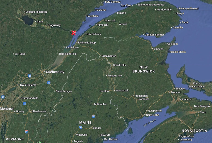
the French set up a fur trading station at Tadoussac on the St. Lawrence River in 1603
Source: Google Maps
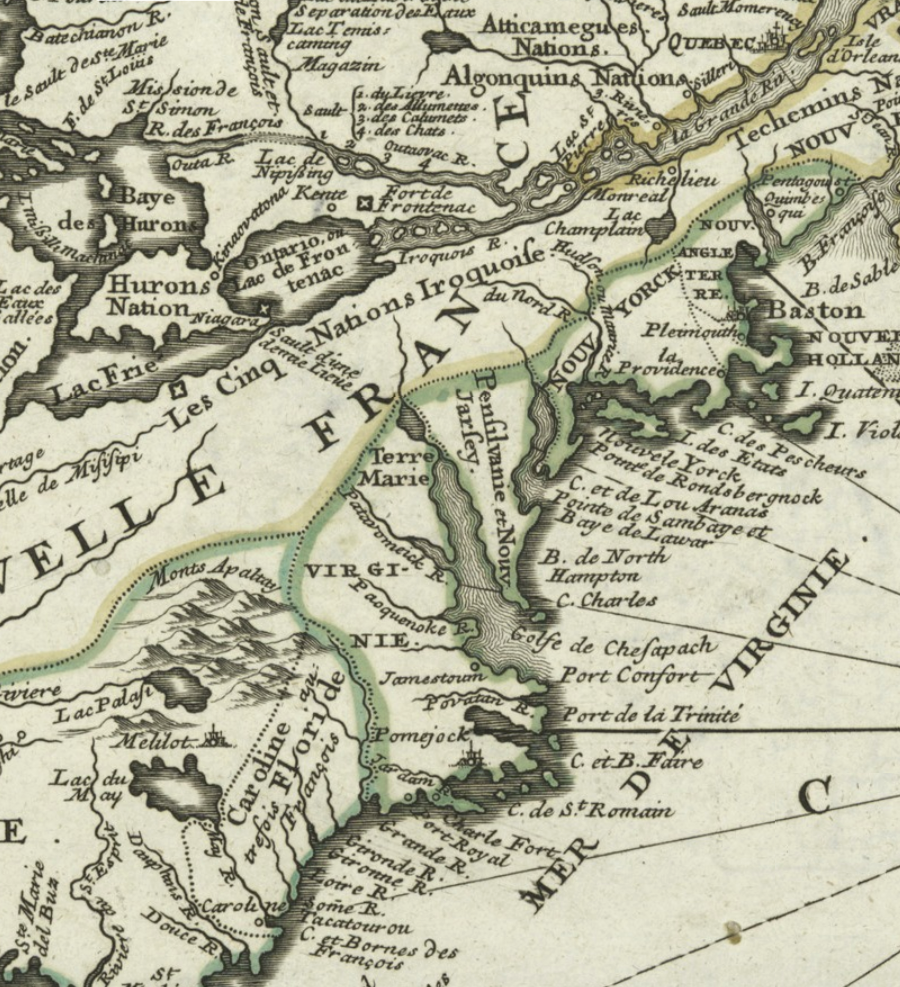
Soon after visiting Canada, Aymar de Chaste died. The French king then gave Pierre Du Gua de Mons a 10-year monopoly over the fur trade between the 40-46th parallels, roughly from the mouth of the Delaware River north to the mouth of the St. Lawrence River.
The charter for Acadia was the legal basis - in French eyes - for de Monts to start the "l'Acadie" at settlement. (In 1681 King Charles II of England also used the 40th parallel of latitude as a boundary. It was identified as the southern edge of the colony that he granted to William Penn.)
In 1604 de Mons crossed the Atlantic Ocean and chose to build a settlement at St. Croix Island. During a very cold winter on that tiny island, in which everything but the wine froze solid, 35 of the 79 men died. Many succumbed to scurvy. Pierre Du Gua de Monts moved the colony in 1605 to Port Royal on Nova Scotia.
The French lasted two years there, with assistance from the Mi'kmaq who already occupied the area. The colonists abandoned Port Royal and returned to France in late 1607, after learning that de Monts had lost his monopoly over the fur trade. Later settlers established modern-day Annapolis Royal at the site.8
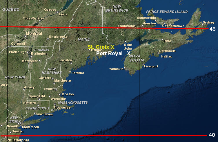
in 1603, Henry IV of France granted Pierre Du Gua de Monts a monopoly on the fur trade between 40-46 degrees latitude, leading to settlements at St. Croix and Port Royal
Map Source: ESRI, ArcGIS Online
More French occupants returned in 1610.
Pierre Du Gua de Monts gained the monopoly and had Champlain explore between 1604-1607 to find a location for a permanent colony. The initial site was Port Royal (later Annapolis Royal) in Nova Scotia.
In 1608, he returned to Stadacona and started a settlement he named Quebec. In 1609 he chose to join the Algonquian-speaking tribes living on the St. Lawrence River in an attack on the Iroquoian-speaking Mohawks. That initiated a centuries-long hostility between the French and the Haudenosaunee tribes.9
Once the English created a settlement in North America, they were the greatest threat to the French in Canada. English colonists from Virginia, led by Captain Samuel Argall, arrived in May 1613 and burned all the French buildings at St. Croix.10
Far inland, the French claimed control over the Mississippi River and Ohio River watersheds based on their "discovery" of that land. In 1684 Rene-Robert Cavelier, sieur de La Salle, in an expeditions based at Montreal, canoed down the Mississippi River and reached a spot almost at the river's mouth.
In 1684 he tried to start a colony at the mouth of the Mississippi River. That attempt failed when the four ships from France with 300 colonists sailed westward pass the entrances in the delta to the river. The French landed near modern Victoria, Texas.
The settlers fought among themselves and with the local Native Americans, and La alle was murdered in 1687 by a fellow colonist. All survivors were captured eventually by the Spanish. Only six finally managed to reach Canada. The French did not establish a successful base on the Gulf of Mexico until 1699, when the Le Moyne brothers initiated French colonization at Mobile (Dauphin Island).
Still, the French explored the interior of North America long before the English. Until the end of the French and Indian War in 1763, the western edge of the Virginia colony was contested territory between France and England. During that time both European nations made alliances and fought with Native Americans in the region.
A fundamental weakness of French colonial strategy was the failure to attract French women to North America and establish a society that would increase the population naturally. Only about 8,000 men and 2,000 women migrated from France to Canada between 1535 and 1763. Many French men melted into the Native American societies as fur traders, creating a society of mixed European and indigenous ancestry
In the English colonies, enough men could be recruited into armies to defeat Native American groups based on commands from English officers. Canada's small population lacked an equivalent base of French residents. By the time of the French and Indian War (1755-1763) there were roughly 1,500,000 English colonists (not counting enslaved people) in the 13 colonies. In contrast, there were only 70,000 French colonists in Canada ("New France").11
A male child of French and Native American couples often became a coureur du bois ("runner of the woods"). That person was a multilingual and multi-cultural entrepreneur with great adaptability in adjusting to shifting requirements of European and Native American societies. The lives of the coureur des bois living in the backcountry were poorly documented, but their influence as cultural brokers allowed the French to control most of the trade of the Great Lakes, Ohio River, and Mississippi River watersheds.
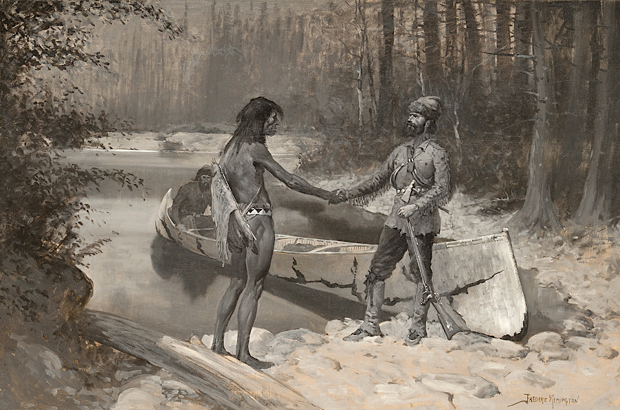
French coureur des bois integrated into Native American society, in contrast to the unwillingness of English colonists to relinquish their European culture
Source: Sid Richardson Museum, The Courrier du Bois and the Savage (by Frederic Remington, 1891)
King Charles II chartered the Hudson's Bay Company in 1670 in hopes of gaining a percentage of the fur trade dominated by the French. Further south in Virginia, however, the English did not reach the Blue Ridge until John Lederer climbed the eastern slope in 1669-1670.
France ceded the Hudson Bay region to Great Britain in the 1713 Treaty of Utrecht, but retained all claims to the Mississippi River watershed. The end of the War of the Spanish Succession in 1713 can be used as a date to identify the steady rise of Great Britain, while France was losing its economic and military capacity to dominate relationships between different nations.
Governor Spotswood led the Knights of the Golden Horseshoe across the Blue Ridge to the Shenandoah River in 1716. He sought to spur settlement on the western edge of the colony so it would serve as a buffer against raids by Native Americans and potentially the French.12
the French established their claim to all lands west of the Alleghenies before Governor Spotswood crossed the Blue Ridge with the Knights of the Golden Horseshoe in 1716
Source: Library of Congress, Carte de la Louisiane et du cours du Mississipi (by Guillaume de L'Isle, 1718)
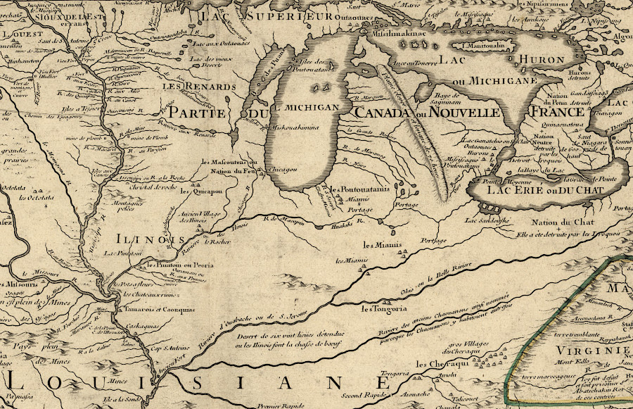
The Native Americans on the east coast of North America were aware of how French forts established far west of the Ohio River offered access to European trade goods. Groups from various tribes chose to migrate from traditional town sites and settle near those forts.
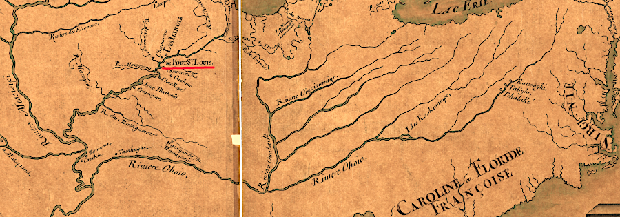
In 1689 a group of Delawares and Mahicans living on the Delaware River at Minisink (near the Delaware Water Gap) visited Fort St. Louis. They encouraged the Shawnee there to migrate east. By recruiting more people, the Delaware and Mahicans hoped to increase their capacity to resist efforts of the five confederated Iroquois tribes in New York (Haudenosaunee) to dominate the territory and trade all the way south to the Potomac River.
In 1692 some Shawnee made the trip to the Chesapeake Bay. A Frenchman, Martin Chartier, joined them after being part of a mutiny at Fort Crevecoeur at what today is Peoria, Illinois. The Shawnee were welcomed by colonists and the Susquehannock, but Maryland officials initially jailed Chartier. The English feared attack by a French force:13
- In Pennsylvania rumors spread that an army of French soldiers and their Indian allies was marching to Maryland, where they would join with English Catholics and overthrow the Protestant governments, handing the colonies over to France.
Casparus Herrman, son of Maryland mapmaker Augustine Hermann, spoke in defense of Chartier. He was released and joined the Shawnee, who initially settled on Hermann's Bohemia Manor along the Elk River. By 1697 they moved westward to be near the Susquehannock town at Conestoga, and established a Shawnee town two miles away called Pequea.
Pennsylvania officials remained suspicious of Chartier, who was willing to sell furs to the French in Quebec when prices were higher there. In 1707 Chartier traveled south to Massanutten Mountain, searching with Franz Louis Michel for a silver mine.14
The French established two colonies in North America, New France in Canada and Louisiana on the Mississippi River. Expenses were so high and revenue from the fur trade was so low that from the perspective of mercantilism, the colonies provided few benefits to the mother country in Europe. Catholic priests welcomed the opportunity to proselytize among the Native Americans, but converts were few. French policy in North America focused on furs and faith, making profits from the fur trade and making converts to the Catholic faith. English policy focused on maximizing the mercantile trade, colonists, in contrast, focused on getting rich
Unlike Great Britain, there was not enough population pressure within France that spurred a significant number of people to emigrate to North America. The number of English colonists rapidly expanded and generated conflicts by continued seizures of land from Native Americans The number of French colonists was so low that Native Americans welcomed the construction of French forts and trading stations. French settlements were viewed as an opportunity to acquire European guns and clothing, not as a prelude to being displaced by farmers.
as late as 1685 the French were still asserting a claim to the Carolina coast
Source: Library of Congress, Amérique septentrion.lle [i.e. septentrionale] (by Jean Baptiste Louis Franquelin, 1685)
Links
- American Archeology
- Archeology
- Canada's Historic Places
- Canadian Museum of History
- Creighton University
- Early Caribbean Digital Archive
- La Grande Louisiane Francaise
- Library and Archives Canada
- Library of Congress
- National Park Service
- Newberry Library
- Public Broadcasting System (PBS)
- University of South Carolina
- University of South Florida
References
1. Thwaites, Reuben Gold, "The Jesuit Relations and Allied Documents: Travels and Explorations of the Jesuit Missionaries in New France, 1610-1791 - Vol. III Acadia, 1611-1616," The Burrows Brothers, 1898, http://puffin.creighton.edu/jesuit/relations/relations_03.html; "The International Fishery of the 16th Century," Newfoundland and Labrador Heritage, https://www.heritage.nf.ca/articles/exploration/16th-century-fishery.php; "French Migration, 1504-1904," Heritage Newfoundland and Labrador, https://www.heritage.nf.ca/articles/society/french-migration.php (last checked January 26, 2026)
2. Seymour I. Schwartz, The Mismapping of America, University of Rochester Press, 2003, pp.45-47 http://books.google.com/books?id=ytxhjRNCeqkC&dq (last checked September 29, 2009)
3. "Long-lost Jacques Cartier settlement rediscovered at Quebec City," Montreal Gazette, August 19, 2006, http://www.canada.com/topics/news/national/story.html?id=4978e603-f67e-4784-807d-7f3911c60829; "Fort Charlesbourg Royal National Historic Site of Canada," Parks Canada, https://www.pc.gc.ca/apps/dfhd/page_nhs_eng.aspx?id=597; "The first voyage (1534)," Cartier-Brébeuf National Historic Site, https://parks.canada.ca/lhn-nhs/qc/cartierbrebeuf/culture/histoire-history/evenement-event/cartier/a; "The second voyage (1535-1536)," Cartier-Brébeuf National Historic Site, https://parks.canada.ca/lhn-nhs/qc/cartierbrebeuf/culture/histoire-history/evenement-event/cartier/b; "The third voyage (1541-1542)," Cartier-Brébeuf National Historic Site, https://parks.canada.ca/lhn-nhs/qc/cartierbrebeuf/culture/histoire-history/evenement-event/cartier/d; "Colonies and Empires - Founding Sites," Virtual Museum on New France, https://www.historymuseum.ca/virtual-museum-of-new-france/colonies-and-empires/founding-sites/; "Stadacona," The Canadian Encyclopedia, https://www.thecanadianencyclopedia.ca/en/article/stadacona; "La Rocque de Roberval, Jean-François de," Dictionary of Canadian Biography, https://www.biographi.ca/en/bio/la_rocque_de_roberval_jean_francois_de_1E.html; "The Explorers - Jacques Cartier 1534-1542," Canadian Museum of History, https://www.historymuseum.ca/virtual-museum-of-new-france/the-explorers/jacques-cartier-1534-1542/ (last checked July 3, 2025)
4. Margaret F. Pickett, Dwayne W. Pickett, The European Struggle to Settle North America: Colonizing Attempts by England, France and Spain, 1521-1608, McFarland, February 8, 2011, p.45, https://books.google.com/books?id=vTkyqDHcBvsC; Bill Marshall, France and the Americas: Culture, Politics, and History: a Multidisciplinary Encyclopedia, Volume 1, ABC-CLIO, 2005, pp.27-28,
https://books.google.com/books?id=jfq5Tp0nq98C; Christopher Allen, Daryl A. Ferguson, Andrew J. Beall, "Santa Elena and America's Lost Century," Santa Elena Foundation, May 25, 2015, pp.8-9, http://santa-elena.org/images/Santa_Elena_History.pdf (last checked April 20, 2016)
5. Harris, Sherwood, "The Tragic Dream of Jean Ribaut," American Heritage, October 1963, http://www.americanheritage.com/content/tragic-dream-jean-ribaut; John T. McGrath, "Admiral Coligny, Jean Ribault, and the East Coast of North America," French Colonial History, Michigan State University Press, Volume 1, 2001, http://msupress.org/journals/fch/; Richard Thornton, Fort Caroline, the Search for America's Lost Heritage, Lulu.com, 2014, p.45, https://books.google.com/books?id=Gx7zBgAAQBAJ; "Historical Background Part I: French Colonization in Florida, 1562-1565," National Oceanic and Atmospheric Administration (NOAA), http://oceanexplorer.noaa.gov/explorations/14lostfleet/background/history-pt1/history-pt1.html; "The Story of a Failed French Settlement in 16th Century North America: Charlesfort," History Is Now, May 31, 2020, https://www.historyisnowmagazine.com/blog/2020/5/31/the-story-of-a-failed-french-settlement-in-16th-century-north-america-charlesfort (last checked April 11, 2025)
6. Richard Thornton, Fort Caroline, the Search for America's Lost Heritage, Lulu.com, 2014, pp.46-50, https://books.google.com/books?id=Gx7zBgAAQBAJ (last checked April 22, 2016)
7. "History of Fort Caroline," Timucuan Ecological & Historic Preserve, Florida, National Park Service, https://www.nps.gov/timu/learn/historyculture/foca_history.htm; Andrew Lawler, The Secret Token: Myth, Obsession, and the Search for the Lost Colony of Roanoke, Doubleday, 2018, p.21, https://www.google.com/books/edition/The_Secret_Token/8yY0DwAAQBAJ (last checked October 25, 2020)
8. "The Legacy of Saint Croix Island," National Park Service, St. Croix Island International Historic Site, https://home.nps.gov/articles/000/legacy-of-saint-croix-island.htm; "Port-Royal National Historic Site," Tourism Nova Scotia, http://www.novascotia.com/see-do/attractions/port-royal-national-historic-site/1462; Aubrey L. Haines, The Yellowstone Story, Volume 1, Yellowstone Library and Museum Association, 1977, p.30, https://www.google.bs/books/edition/_/TShVpwAACAAJ; Robert Leckie, "A Few Acres of Snow:" The Saga of the French and Indian Wars John Wiley and Sons, 1999, p.49, https://www.google.com/books/edition/A_Few_Acres_of_Snow/3p4EFGW2XowC (last checked January 26, 2026)
9. "The Explorers: Samuel de Champlain 1604-1616," Virtual Museum of New France, https://www.historymuseum.ca/virtual-museum-of-new-france/the-explorers/samuel-de-champlain-1604-1616/; "Chapter 10: 1609-1615, Champlain's Battles with the Mohawks and Oneidas," in "History of the Mohawk Valley: Gateway to the West 1614-1925," Schenectady Digital History Archive, https://www.schenectadyhistory.org/resources/mvgw/history/010.html (last checked January 16, 2026)
10. "History & Culture," Saint Croix Island International Historic Site, https://www.nps.gov/sacr/learn/historyculture/index.htm; "St. Croix Island, The Lost French Colony of Maine," New England Historical Society, https://newenglandhistoricalsociety.com/st-croix-island-lost-french-colony-maine/; "History,"
Port-Royal National Historic Site, https://parks.canada.ca/lhn-nhs/ns/portroyal/culture/histoire-history; "Port Royal (Annapolis Royal) - Victim of intermittent wars between two empires," Acadie, https://acadie.cheminsdelafrancophonie.org/en/port-royal-annapolis-royal-victim-of-intermittent-wars-between-two-empires/ (last checked July 3, 2025)
11. "Early Explorers of the Gulf, Basin, and the Mississippi River - Part B," Maritime Museum Louisiana, https://maritimemuseumlouisiana.org/maritimeblog/early-explorers-of-the-gulf-basin-and-the-mississippi-river-part-b; "Population Settlement of New France," The Canadian Encyclopedia, https://www.thecanadianencyclopedia.ca/en/article/peuplement-de-la-nouvelle-france (last checked July 3, 202)
12. "Hudson's Bay Company," The Canadian Encyclopedia, https://www.thecanadianencyclopedia.ca/en/article/hudsons-bay-company; John Lederer, The discoveries of John Lederer, in three several marches from Virginia to the west of Carolina, and other parts of the continent: begun in March, 1669, and ended in September, 1670, together with a general map of the whole territory which he traversed, 1891, https://lccn.loc.gov/rc01002786; "Exploring the Knights of the Golden Horseshoe," Country Zest and Style, Fall 2020 , https://issuu.com/uncoveringthevalley/docs/cz_fall20_issuu/s/11108532; "War of the Spanish Succession," The Canadian Encyclopedia, https://www.thecanadianencyclopedia.ca/en/article/war-of-the-spanish-succession (last checked May 28, 2025)
13. "Cohongorooto: The Potomac Above the Falls - Archeological Identification and Evaluation Study of C&O Canal National Historical Park Rock Creek to Sandy Hook (Mile Markers 0 To 59), Volume I," National Park Service, December 2005, p.59, https://www.whilbr.org/sites/default/files/2023-03/Archealogical_Identification_RockCreek-Sandy_Hook2.pdf; "Martin Chartier," DonaldKautz.com blog, July 14, 2021, https://donaldkautz.com/blog/martin-chartier/ (last checked June 27, 2025)
14. "Cohongorooto: The Potomac Above the Falls - Archeological Identification and Evaluation Study of C&O Canal National Historical Park Rock Creek to Sandy Hook (Mile Markers 0 To 59), Volume I," National Park Service, December 2005, pp.63-64, https://www.whilbr.org/sites/default/files/2023-03/Archealogical_Identification_RockCreek-Sandy_Hook2.pdf (last checked March 31, 2025)
in 1702, the French claimed Nouvelle France extended to the head of the Chesapeake Bay, including the Susquehannock territory
Source: New York Public Library, Le Canada, ou Nouvelle France, la Floride, la Virginie, Pensilvanie, Caroline, Nouvelle Angleterre et Nouvelle Yorck, l'Isle de Terre Neuve, la Louisiane, et le cours de la riviere de Misisipi (Nicolas de Fer, 1702)
Exploring Land, Settling Frontiers
Virginia Places