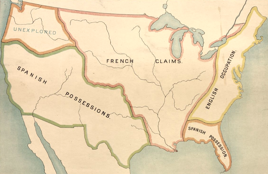
at the start of the French and Indian War, the French claimed the center of the North American continent and sought to contain the English east of the Alleghenies
Source: Library of Congress, "Robertson's geographic-historical series illustrating the history of America and the United States: from 1492 to the present time," English, French and Spanish Possessions
France and Britain were international rivals seeking wealth and power. This competition affected Virginia, as well as islands in the Caribbean and India. England, France, Spain, the Netherlands, and even Sweden fought each other overseas in North America and he Caribbean, without formally declaring war and risking invasion of the homelands in Europe.
The French and Indian War was fought in North America between 1755-63 by French and British forces (including colonial militia). The "Indian" part of the name is key to understanding the conflict. Native Americans chose to ally with either England or France. Competition for their trade and support created conflicts that extended far from the cities of Montreal and Quebec along the St. Lawrence River, and from the English settlements on the Fall Line.
The war was one of a continuing chain of English-French conflicts in North America, stretching back to the earliest settlements by the European rivals.
Starting in the 1500's, the French had relied upon various Native American groups living within the interior of New France to hunt and process deer skins and furs, then exchange them with other tribes further east. French ships traded for beaver and other skins at Tadoussac on the St. Lawrence River downstream from Quebec, which Samuel de Champlain started in 1608.
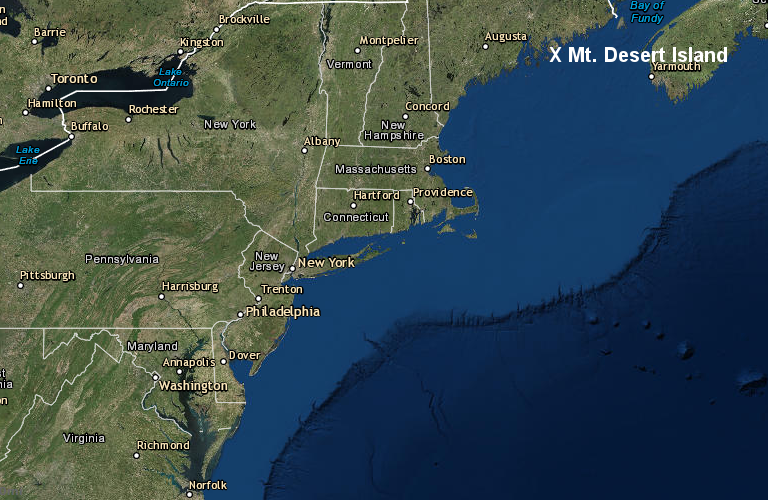
The French established complex trade deals with different Native American groups, but from the beginning the English and French chose to fight rather than trade with each other. In 1613, Virginia colonists sailed north from Jamestown to destroy a French settlement on Mt. Desert Island, now part of Acadia National Park.1
the Virginia colonists sailed 650 miles north to destroy the French settlement on Mt. Desert Island in 1613
Source: ESRI, ArcGIS Online
In the Great Peace of 1701, the Mohawk and other members of the Five Nations (the Tuscarora did not join until the 1720's) agreed to stop fighting the French on their northern border. This freed up the Iroquois to combat the Mahican on the east, their rivals for trade with the Dutch fort at Albany. Peace with New France also allowed the Iroquois to focus on conquering the Susquehanna and Delaware to the south, plus westward expansion to establish Five Nations hegemony over tribes living in the Ohio River valley.
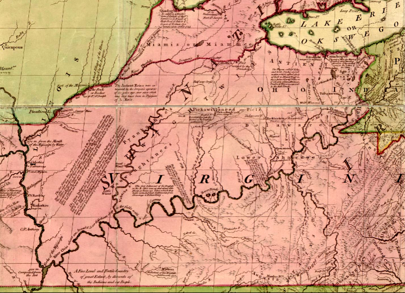
The French built Fort Detroit in 1701, extending their trading network further to the west. It was located on territory that Virginia had claimed since 1609.
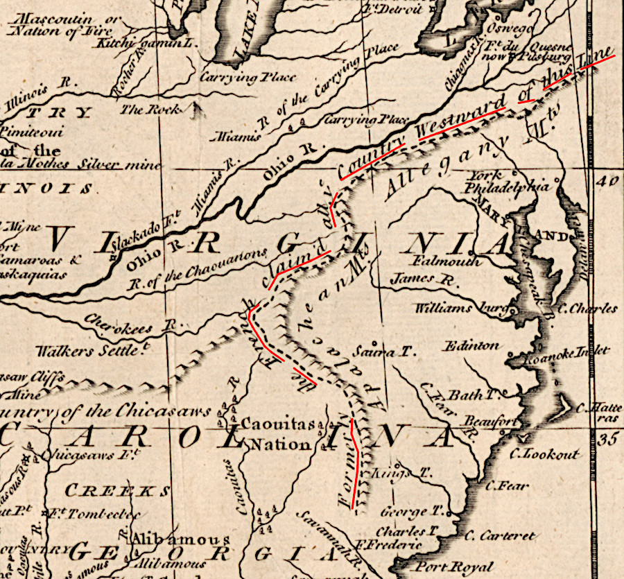
Governor Spotswood viewed new French forts in the Ohio River and Mississippi River as encroachment into Virginia's territory
Source: John Carter Brown Library at Brown University, A new chart of the English Empire in North America (by Cyprian Southack, 1717)
Virginia's claim to the Ohio Country westward to the Mississippi River and beyond was based its Second Charter, which granted:2
unto the said Treasurer and Company, and their Successors... all that Space and Circuit of Land, lying from the Sea Coast of the Precinct aforesaid, up into the Land throughout from Sea to Sea, West and Northwest.
In contrast to the economy established by the French based on fur trading, English colonies in North America were based on agriculture. Virginia and Maryland relied upon one staple crop, tobacco, which depleted nutrients in the soil within three years. To find fresh land to plant tobacco, English colonists displaced Native American tribes. Occupying their land and preventing traditional hunting practices led to conflict, and a desire of the colonists to push Native Americans out of Virginia.
The sale of tobacco to customers in Europe generated profits for business leaders in London. Taxes on tobacco generated an extraordinary profit for the English government. Land speculation steadily fueled the growth of a wealthy gentry class in Virginia, though the price of tobacco grown in the Middle Atlantic colonies varied based on supply, demand, and manipulation of the market by London businessmen.
The colony's gentry dominated colonial government in Virginia, and the colony's economy was based on a ever-growing population continuously buying western lands. The colonial government located in Jamestown and then in Williamsburg (after 1699) granted those lands at low cost to a select group of powerful families. They profited by displacing Native Americans and selling parcels to new farmers. Growing tobacco was profitable, but the major fortunes of the First Families of Virginia (FFV's) were made from land speculation.
That land speculation by Virginians, more than any other colony, was the fundamental cause of the French and Indian War. Full-scale conflict in the New World between England and France had been delayed 200 years, in part because the two countries initially separated their colonies by great distances. However, as English settlement expanded into the trading backcountry that fed furs to Montreal and Quebec, competition for trade with Native American tribes increased.
The efforts of the Ohio Company to occupy lands at the Forks of the Ohio River finally triggered the war which determined which European power would control the interior of North America, east of the Mississippi River.
There was a long tradition of warfare between French colonists and Native Americans, pre-dating the settlement at Quebec in 1608. Warfare between English colonists and Native Americans started in the first days of Jamestown. Various groups of Native Americans resisted efforts by colonists to convert their towns and hunting territories into farms.
The paramount chiefdom of Powhatan was disrupted despite uprisings in 1622 and 1644, and most of the Native Americans forced to leave the Coastal Plain. In the 1670's, Virginia colonists intruded into the territory claimed by the Dogue at the same time the Susquehanna moved closer to the Potomac River. Resistance by those two tribes in 1676 helped spark Bacon's Rebellion in Virginia. That same year, King Philip's War in New England devastated 17 towns and damaged the economy severely:3
Per-capita incomes in New England did not recover their 1675 levels until 1775... A large share of the capital of the puritan fathers... had been consumed in the fires of King Philip's War.
Throughout the first half of the 1700's, conflicts between France and England in Europe overlapped with European and Native American rivalries for control of land and trade in North America. Iroquois expansionism, fueled in part by skillful negotiation of alliances with colonial representatives of France and England, forced the Susquehanna and Delaware out of their traditional territories and made them dependent upon the Six Nations.
West of the Ohio River, the Shawnee were the most willing to assert their independence of the Iroquois. The Erie, Mingo, Wyandot, Ottawa, and other tribes were forced to acknowledge the power of the Six Nations. In negotiations, dependent tribes were forced to accept arrangements acceptable to the Iroquois, and leaders of subordinate tribes were designated as only "half kings."
The Ohio Company's disruption of relationships in the backcountry of the Ohio River valley started in the late 1740's. Speculative land claims by that company was just one of many disputes between France and England; the conflict could have become just another minor event in a long pattern of conflicts. The overlapping territorial claims by the French based on the St. Lawrence River, and by the English speculators based in Virginia, grew into a decisive world war because the buffer of undisputed land between New France and the English colonies finally had been exhausted.
The Ohio Company intended to occupy the backcountry of the French traders and block their economic opportunity. The French refused to concede the valley of La Belle Riviere, and maneuvered to dominate the Native Americans who lived there. The traders from Pennsylvania sought to have Native American groups interfere with traders from Virginia and vice-versa. The colonial governors failed to work together to implement a common negotiation strategy with Native American tribes.
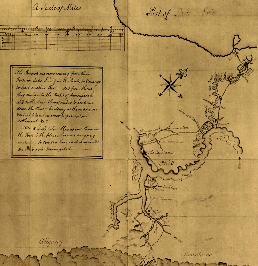
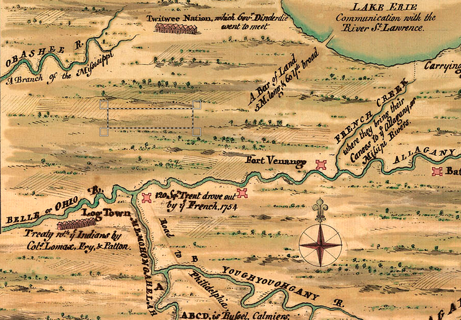
Choosing a time for the start of the French and Indian War requires assessing the events that preceded official declaration of war in 1756. King George's War started in 1744, and ended in 1748 with only a temporary peace. In 1749, Captain Bienville de Celeron led an expedition down the Ohio River to deter Native Americans from selling furs to the English, and to assert France's claim to the entire Mississippi River watershed. To document the "we were here first" claim, Celeron buried lead plates at six spots, including the Forks of the Ohio where the Allegheny and Monongahela rivers flow together to form the headwaters of the Ohio River.
In 1754, open conflict re-started in North America at the Forks of the Ohio. In 1756 the two countries started the Seven Years War in Europe. That led Great Britain to send enough military forces from Europe to North America to tip the balance. The Royal Navy blocked French troops and supplies from getting across the Atlantic Ocean, and Montreal and Quebec were captured.
In the 1763 Treaty of Paris, France ceded its claims to Canada and the Mississippi River watershed to Great Britain. Spain surrendered East and West Florida to Great Britain. France compensated its ally by transferring Louisiana to Spain. None of the Native American tribes who occupied the land were represented in the negotiations to transfer "ownership" of North America among European nations.
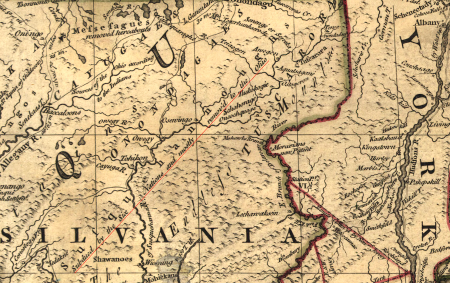
John Mitchell's 1755 map of English claims in North America displayed the location of Kuskusky and Logstown (and demonstrated the old adage that "all interesting places are located at the edge of separate map sheets...")
Source: Library of Congress, A map of the British and French dominions in North America (John Mitchell, 1755)
In 1753, at the age of 22, George Washington is given credit for initiating the French and Indian War. It ended up being the first world war fought by European countries.
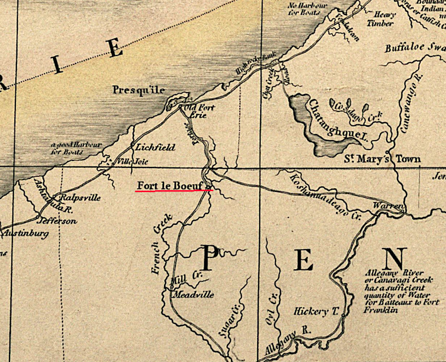
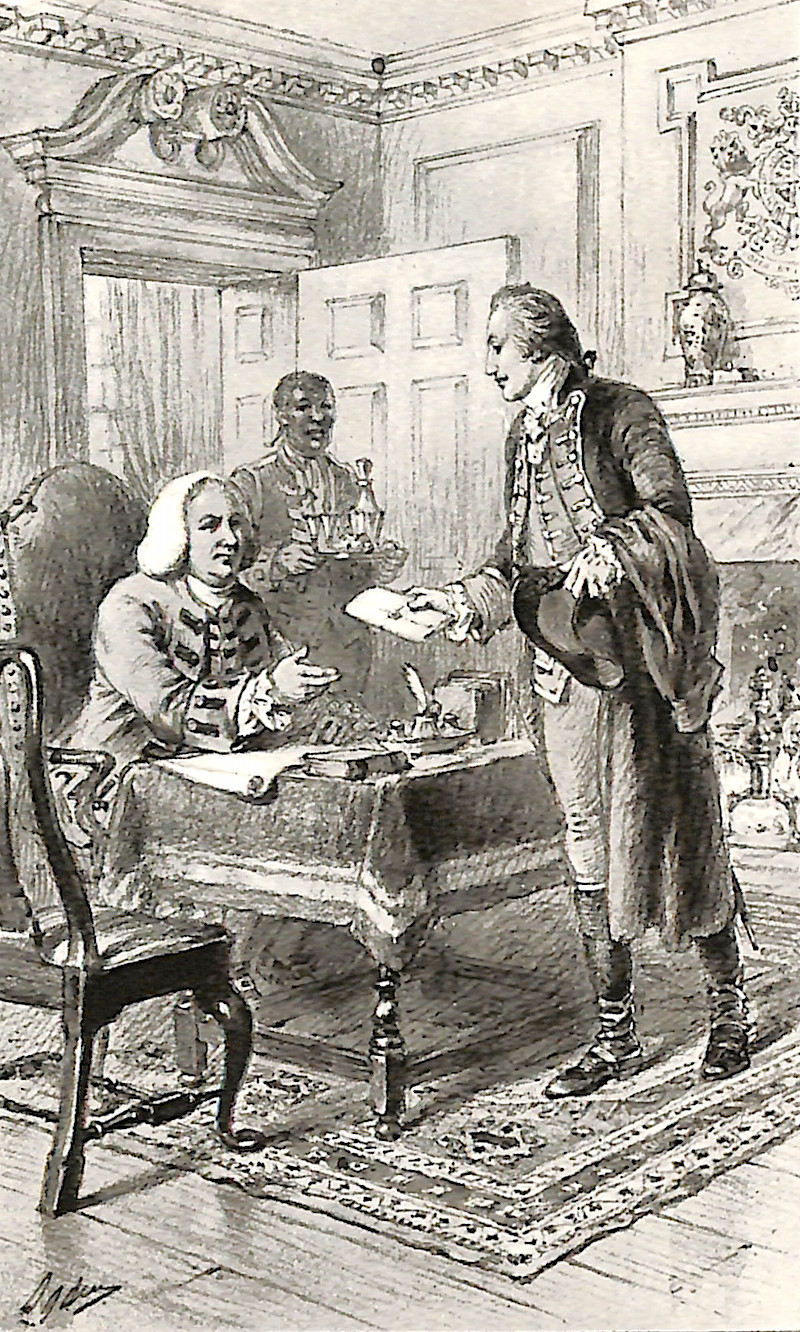
In late 1753, Lord Dinwiddie sent George Washington to notify Legardeur de St. Pierre at Fort de la Riviere au Boeuf that the French had encroached into territory claimed by the English. Fort le Boeuf was one of the military bases established by the French on the southern edge of Lake Ontario and in what today is northern Pennsylvania. French power extended far south of the modern US-Canada border. Since 1734, the French had also occupied a fort that controlled Lake Champlain in what today is New York.
Part of the English claim to the Ohio River watershed was based on the 1744 Treaty of Lancaster. In 1749, after the Iroquois sold their claim to that land, the Ohio Company obtained a land grant for up to 500,000 acres of land south of the Ohio River. The Loyal Land Company got a grant for 800,000 acres. Their ownership claims would evaporate if the French succeeded in establishing control of the land west of the Allegheny Front.
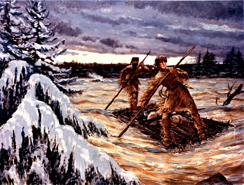
Washington had surveyed in the backcountry of Virginia, but had never gone north into Pennsylvania. To help get to Fort Le Boeuf, Washington hired Christopher Gist as his guide. Gist had already traveled in 1750 and 1751 into the watershed of the Ohio River for the Ohio Company, which had constructed a warehouse at Wills Creek in 1749. He identified Nemacolin's Trail, the route from Wills Creek to the Youghiogheny River and the Forks of the Ohio.
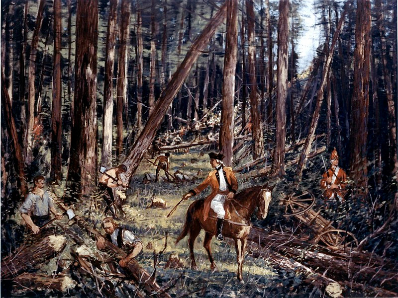
George Washington and Christopher Gist made a hazardous trip through the backcountry to reach the French at Fort Le Boeuf in 1753
Source: Federal Highway Administration, 1753 Washington Crossing (painting by Carl Rakeman)
Together with a few Indian allies, Washington reached the French headquarters near Lake Erie (modern-day New Waterford, Pennsylvania) despite November snow and ice. The party was treated well at Fort Le Boeuf; at the time; France and England were at peace. The French officers isolated for the winter in the middle of nowhere must have appreciated the opportunity to converse with a "gentleman," but their polite treatment did not extend to serious consideration of the message from Governor Dinwiddie.
The claim that the Ohio River was British territory was quickly rejected. Washington's tiny party at the fort was just a scouting expedition, and to the French any military threat from Williamsburg must have seemed distant. The French were more concerned with the Native American allies that accompanied Washington and Gist, and worked hard to shift their loyalties to the French. West of the lands already settled by colonists, the French understood well that Native Americans armed with European weapons had the manpower needed to control territory.
in 1753 the French had moved as far south as Fort Le Boeuf, built on a tributary of the Allegheny River
Source: Norman B. Leventhal Map & Education Center, Boston Public Library, A map of the province of Upper Canada (James Wyld, 1836)
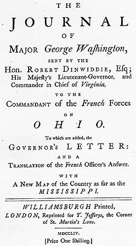
Washington hurried back to Williamsburg from Fort Le Boeuf in order to alert Dinwiddie as fast as possible. He survived a dunking in an ice-filled river and an attempt to kill him by a Native American in his traveling party.
After George Washington submitted his written report, the governor sent it to London where the document was published as The Journal of Major George Washington. The young Virginian gained his first recognition in Europe through his report from the frontier.
In 1754, the Ohio Company started building Fort Prince George (also known as Fort Trent) at the Forks of the Ohio. To support it, Governor Dinwiddie began recruiting six companies of volunteers, 50 men in each company, and appointed Joshua Fry as colonel to lead the force. He appointed George Washington as Lieutenant Colonel, even though he was untrained and untested in battle.
Governor Dinwiddie had no pool of trained and experienced officers from which to draw. The colony had no standing army, and the British had stationed no Regular Army troops in Virginia. There was one independent company in Georgia, two in South Carolina, and four in New York to provide protection primarily against Native American attacks. At Dinwiddie's request, King George II ordered a South Carolina company and two from New York to come to Virginia.
Under the colony's militia law, Governor Dinwiddie could mobilize the county militia. However, the militia was a part-time military force. Men were poorly trained and poorly armed, with minimal expectations of having to fight unless there was an uprising of enslaved workers or a raid by Native Americans. Men who were ordered to march to the Ohio River, requiring them to leave farms for many weeks, were expected to resist and avoid the duty. Governor Dunmore expected to hear the claim that they could not be sent outside the boundaries of Virginia in violation of the militia act.
So the governor chose to recruit a special provincial force of 300 volunteers. He promised to provide the volunteers a land grant at the end of their service, in addition to two shillings/day pay for their time. At the time, militia serving more than five days were paid only 8 pence/day. Dinwiddie proclaimed that 200,000 acres near the Forks of the Ohio were to be used for land bounties.
The General Assembly authorized £10,000 for defense and other colonies were asked to provide support in a "common Cause." The assemblies in Pennsylvania and Maryland declined, but North and South Carolina agreed to provide financial support.
Even in Virginia, legislators objected to funding the provincial force. Some burgesses considered it to be an inappropriate government subsidy to the Ohio Company so it could proceed with survey and sale of its land grant. Washington's report of the visit to Fort le Boeuf and the threat of the French could have been just part of a "Scheme to promote the Interest of a private Company."
Two companies marched westward from Alexandria on April 2, led by Washington. On the march he received a report that the French had captured the Ohio Company fort on April 17.
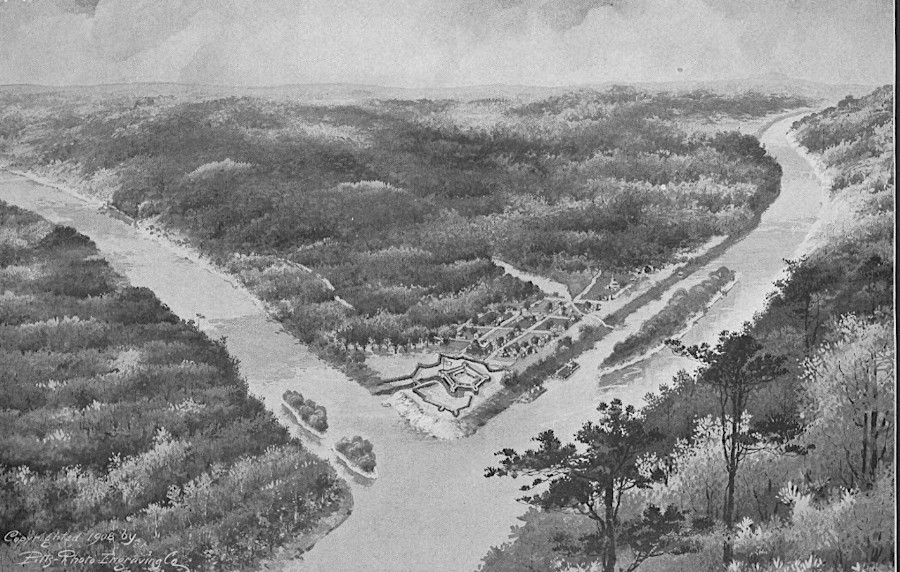
The French, led by Claude Pierre Pécaudy, sieur de Contrecoeur, built Fort Duquesne at the site. That fort was named after Michel-Ange Duquesne de Menneville, Governor-General of New France. It was one of several planned along the Ohio River to connect Canada with the French colony of Louisiana.
Washington reached Wills Creek with 150 men. The officers held a council of war there while waiting the arrival of Colonel Fry with the rest of the force. They decided to march further west and set up a fort at the confluence of the Redstone and Monongahela rivers, 37 miles from the Forks of the Ohio. Unless the Virginians moved forward, the soldiers would become difficult to manage and the Native American allies awaiting their arrival would melt away.
There the force would wait for reinforcements they requested from Alexandria, since they had learned the French had nearly 1,000 men and substantial numbers of Native American allies at Fort Duquesne. Those reinforcements, led by Colonel Fry, were needed in part to improve the road west to the Monongahela River. A road would allow wagons to haul the cannon that were essential for an attack on Fort Duquesne.
While riding to Wills Creek, Colonel Fry fell off his horse. He was severely injured and could not continue, and eventually died on May 31. As second-in-command, George Washington assumed leadership of the Virginia force.
As the Virginians marched west of the Great Meadows, they were alerted by their Native American scouts that a group of French soldiers were nearby. His allies were led by Tanaghrisson, a member of the Seneca tribe who had been sent by the Iroquois to monitor the Delaware and Shawnee living at Logstown.
Tanaghrisson had given the English permission to construct Trent's Fort, welcoming traders bringing new access to weapons, gunpowder, and textiles. When the French occupied the fort, they insulted the Native American ally of the British. A French officer known as La Force later went to Tanaghrisson's base of operations at Logstown. He warned the people there that the French would be victorious and that their future, as British supporters, was bleak.
The Iroquois had been enemies of the French since 1609, when Samuel de Champlain had helped Algonquian-speaking Native Americans on the St. Lawrence River attack the Mohawks. The "Half King" may not have desired for any British settlers to occupy the Ohio River Valley, but the French were his primary enemy - and Washington was there to displace the French. Tanaghrisson chose to support the British colonists rather than stay neutral.
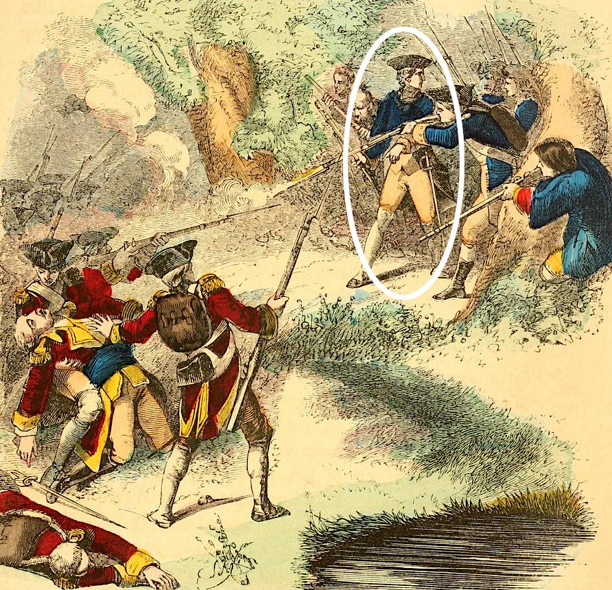
Tanaghrisson led the Virginians to the French camp on the morning of May 28, 1754, and Washington led the attack against the sleeping party. According to a report from one of the Native Americans who accompanied the Virginians to attack the French that was recorded in October, Washington himself fired the first shot.
22-year old George Washington may have been a bystander, or he may have fired the first shot at Jumonville Glen
Source: Joel Tyler Headley, The illustrated life of Washington (1859, p.47)
The site of the attack is now called Jumonville Glen, named after the French leader who died in the British ambush. In an ambush that lasted 15 minutes, 13 of the French and one of the Virginians were killed.
After the French surrendered, Tanacharison took a hatchet and bashed out the brains of Joseph Coulon de Villiers de Jumonville. He may have thought he was killing La Force. Another possibility is that he may have killed the French leader in order to increase the potential of a war in which the British rather than the French would end up controlling the Ohio River watershed. That scenario would make the most sense if the Half King assumed the British would re-establish Trent's Fort, but not send a large number of settlers across the Appalachian Mountains.
Knowing the French would send a larger force of soldiers and Native American allies from Fort Duquesne, Washington began to retreat back to Virginia. He failed to maintain good relations with his Native American allies. When they deserted the Virginians, he lost the intelligence needed to understand what threat he faced.
Anticipating the French coming from Fort Duquesne to retaliate would catch up, the Virginians built a small fort with a palisade around it in an open field at Great Meadows. The South Carolina independent company arrived in time for the battle. Washington and the other commander disputed who was in charge, since his commission from the Virginia governor ranked lower than the commission issued by King George II for the officer in command of the independent company. The two New York independent companies reached Alexandria only after the Great Meadows battle.
Hours of fighting on July 3, 1754 demonstrated that Fort Necessity was inadequate for defense. The Virginians and the South Carolina troops had to surrender.
George Washington signed a document, written in French, in which he admitted to "assassinating" the French leader who had traveled from Fort Duquesne to meet with the Virginians. The French claimed their men had been sent to deliver a message to the Virginians telling them to leave French territory, comparable to how Governor Dinwiddie had dispatched Washington to Fort le Boeuf the previous winter. From the French perspective, the Virginians had murdered a French ambassador.
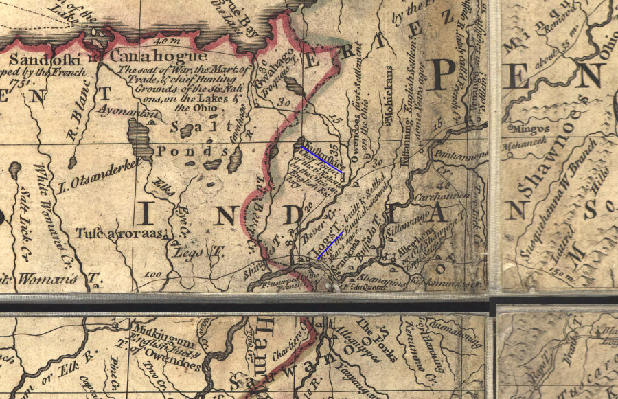
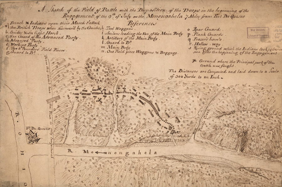
the French moved forces and supplies from Lake Erie in order to build Fort Duquesne, where the Allegheny and Monongahela rivers join to form the Ohio River
Source: Library of Congress, Copy of a sketch of the Monongahela, with the field of battle
Today we know George Washington grew up to be rich and famous, the "Father of the Country" and the "Indispensable Man" without whom the United States may have failed to coalesce into one united country. In 1755, however, Washington was not a success. He appears to have been an unhappy young man who had made a bad personal decision to go to Fort de la Riviere au Boeuf, then fight the French:4
...I am so little dispirited at what has happen'd, that I am always ready and always willing, to do my Country any Services that I am capable off; but never upon the Terms I have done, having suffer'd much in my private fortune, besides impairing one of the best of Constitution's.
I was employ'd to go a journey in the Winter (when I believe few or none wou'd have undertaken it) and what did I get by it? my expenses borne! I then was appointed with trifling Pay to conduct an handful of Men to the Ohio. What did I get by this? Why, after putting myself to a considerable expence in equipping and providing necessarys for the Campaigne I went out, was soundly beaten, lost them all--came in, and had my Commission taken from me or, in other words my Corn'd, reduced, under pretence of an Order from home.
I then went out a Volunteer with Genl. Braddock and lost all my Horses and many other things, but this being a voluntary act, I shou'd not have mention'd it, was it not to shew that I have been upon the loosing order ever since I enter'd the Service, which is now near two year's; so that I think I can't be blare'd, shou'd I, if I leave my Family again, end'vt. to do it upon such terms as to prevent my sufferg., (to gain by it, is the least of my expectation).
I doubt not but you have heard the particulars of our shameful defeat, which really was so scandalous that I hate to have it mention'd...
The French and Indian War may have been inevitable, since two European powers sought control over the same Ohio River land. The war was initiated by the actions of the military force led by Washington in 1754. Odds are high that if someone else had been in charge of the Virginia Regiment in 1754, then a war between France and Great Britain would have been triggered by some other incident in the 1750's.
Even if war was inevitable, the role of the Virginians was not. Why were the Virginians fighting the French so far from Williamsburg? Jumonville Glen, Fort Necessity, and Pittsburg (Fort Duquesne/Fort Pitt) are all in Pennsylvania today, so why didn't Pennsylvanians fight the initial battles?
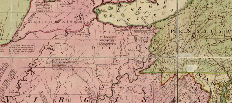
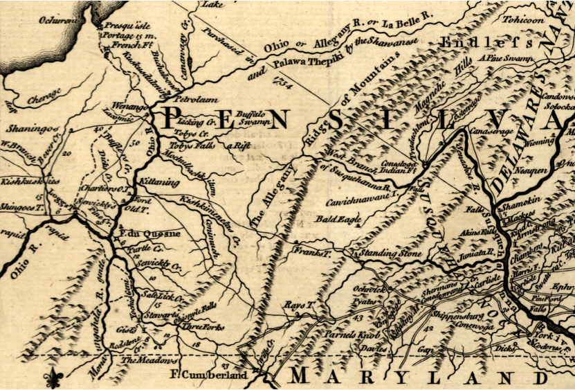
the contest between France and England for control of lands west of the Allegheny Mountains led to the French and Indian War, triggered by George Washington's "assassination" of a French official at Jumonville Glen in 1754
Source: Library of Congress, A map of the province of Pensilvania (1756)
Part of the answer is that Virginia claimed the Forks of the Ohio were within its colonial boundaries, and land-hungry Virginians in the General Assembly and on the governor's Council had organized the Ohio Company in 1747 to settle the area. Pennsylvania colonists were slow to move to the Ohio River. The Virginians saw an opportunity to gain control over western territory, and had no qualms about citing the colonial charters as the basis for their land claims. Unlike the pacifists Quakers who controlled the Pennsylvania Assembly in the early 1750's, the House of Burgesses was willing to raise an army and fight for that land.
The average Virginian hungered to own acreage. Men were willing to fight Native Americans, the French, or even Pennsylvanians to obtain cheap land. In contrast, the Pennsylvania Assembly lacked the avarice and the willingness to fight.
Benjamin Franklin sought to overcome the Pennsylvania Assembly's reluctance. He championed a union of the colonies to strengthen their ability to defend against attack by the French and their Native American allies. His proposal for unifying the colonies mimicked the loose union established by the four New England colonies between 1643-1684 to defend against the Dutch, French, and Native Americans.
Representatives of Maryland, Pennsylvania, New York, Connecticut, Rhode Island, Massachusetts and New Hampshire endorsed a plan of union at a June 10-July 10, 1754 meeting in Albany. Under the Albany Plan, all the colonies would select representatives to serve in a Grand Council, an American equivalent to Parliament. That representative body would control negotiations with Native Americans and manage a united defense. The king in London would appoint a President General with authority to veto any measure passed by that representative body.
The Albany Plan of Union would have benefitted Franklin's struggle to reduce the control of the Penn family, which governed Pennsylvania as a proprietary colony. A Grand Council and a President General could force the Penn family to pay military costs, overcoming their unwillingness to raise taxes for defense. An overarching inter-colonial government also could overcome the pacifist policies of the Quakers who controlled the Pennsylvania Assembly in 1754 and lead to expansion of Pennsylvania's militia.
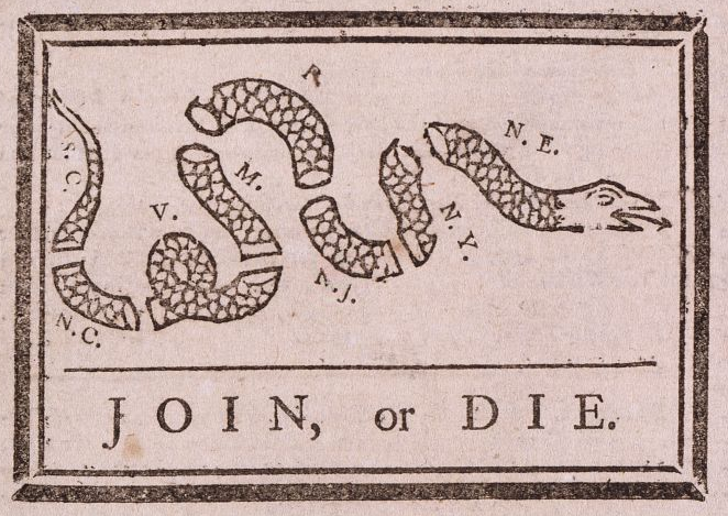
in 1754 at the start of the French and Indian War, Benjamin Franklin called unsuccessfully for united colonial action
Source: Library of Congress, Join or Die (by Benjamin Franklin, March 9, 1754)
Though Franklin convinced the delegates in Albany to support his 1754 proposal, no colonial legislature approved the proposed Plan of Union. Leaders in individual colonies were unwilling to cede their power to a separate General Council or to a royally-appointed President General, an executive who would have additional power beyond that of the royal governors. The preferred option for colonial leaders was for Great Britain to send an army to North America, force the French to withdraw from the Ohio River Valley, demobilize the army, send the troops back across the Atlantic Ocean, and then return to colonial business as usual without having to pay for the troops.5
London did send General Braddock with the 44th and 48th regiments of British Regulars to capture Fort Duquesne. The British landed first at Hampton Roads, then Braddock established his base of operations at John Carlyle's house in Alexandria. Braddock assembled a council there with the governors of Virginia, Maryland, Pennsylvania, New York, and Massachusetts, what Carlyle called "the Grandest Congress held at my home ever known on the Continent." The 1754 meeting at Albany had not included the royal governors.
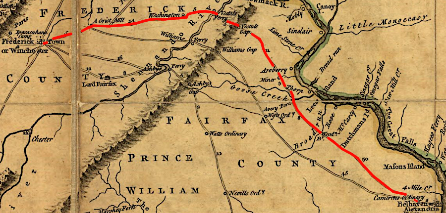
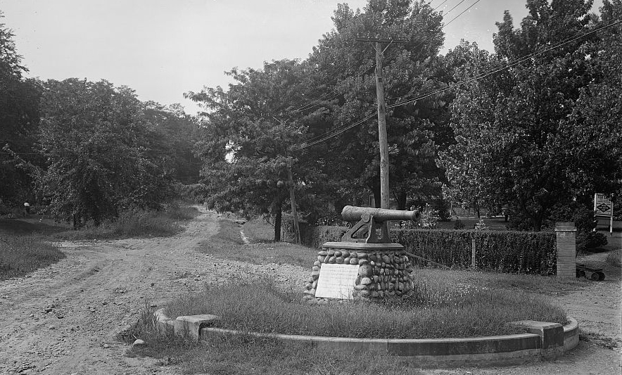
General Braddock eventually organized an army of 2,400 men. He sent the 44th Regiment west to Winchester, before gathering all his forces at Fort Cumberland in Maryland. That regiment marched by way of the Fairfax County courthouse (modern Tysons) and followed modern Route 7. The Society of Colonial Dames of America erected a monument in 1915 to mark Braddock's path, placing a cannon at the intersection of Braddock and Russell roads. The 44th Regiment crossed the Blue Ridge at Vestal's Gap. They completed the 97-mile march from Alexandria to Winchester in six days, averaging 16 miles per day.
the 44th Regiment marched west from Alexandria through modern-day Tysons and on Route 7, via Leesburg and then Vestal Gap to Winchester
Source: Library of Congress, A map of the most inhabited part of Virginia (by Peter Jefferson and Joshua Fry, 1755)
Those troops did not go through Centreville; they did not use the route now called Braddock Road. Nonetheless, the myth continues that the army ran into mud at Centreville and, to lighten the load, buried a cannon filled with gold there. Braddock Road may have gotten its name because farmers used it to bring crops and other supplies eastward to the British Regulars while they were in Alexandria.
Braddock himself traveled with the 48th Regiment. It crossed the Potomac River to Maryland, landing on the north bank in what today is Washington DC. Braddock's Rock in Washington, DC marks the spot on the northern bank of the Potomac River where, supposedly, that regiment landed. The 48th Regiment then marched north of the Potomac River to Fort Cumberland.6
a cannon supposedly abandoned by General Braddock was used in 1915 to mark his trail from Alexandria towards Fort Duquesne
Source: Library of Congress, Keefer, Braddock Cannon, Alex., Va.
the Braddock cannon is still located at the intersection of Braddock and Russell roads in Alexandria
Source: ESRI, ArcGIS Online
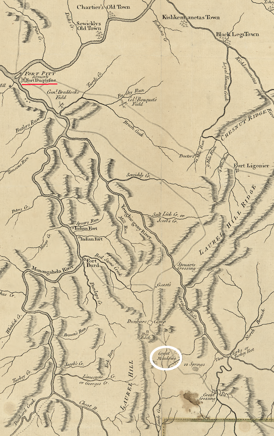
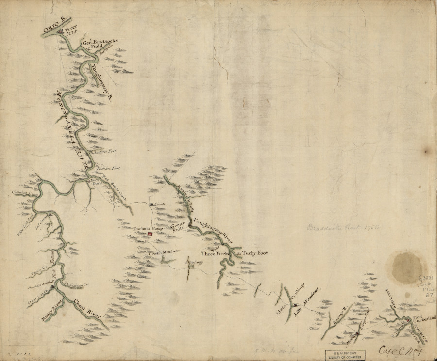
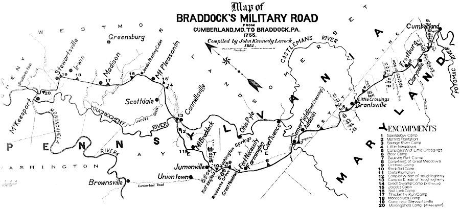
From what is now Cumberland, Maryland, pioneers and soldiers cut a road through the forested wilderness towards Fort Duquesne. That route followed Nemacolin's Trail, carved in 1750 by the Ohio Company. It went past the site of Fort Necessity to the headwaters of Redstone Creek. The road was made 12' wide, so wagons could pull the cannon needed to knock down the walls and ramparts at Fort Duquesne.
General Braddock's engineers cut a new road through wooded wilderness from Cumberland, Maryland towards the Forks of the Ohio
Source: Federal Highway Administration, 1755 Braddock's Road (painting by Carl Rakeman)
with support from Virginians who wanted better access to the Ohio River, Braddock directed his army to cut a 12' wide road from Fort Cumberland (now Cumberland, Maryland) to Fort Duquesne
Source: Library of Congress, "Robertson's geographic-historical series illustrating the history of America and the United States: from 1492 to the present time," Braddock's Defeat
construction of General Braddock's road to move artillery and supplies slowed the march from Cumberland to Fort Duquesne in 1755
Source: The National Road in Pennsylvania
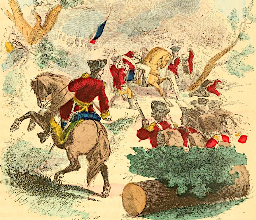
Before reaching the French fort, Braddock split his army. He led the advance force traveling without cannon and heavy supplies. Near Fort Duquesne the British were surprised by a smaller force of French and Native American warriors who took full advantage of the wooded terrain.
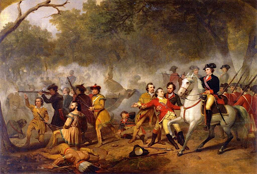
The British column was quickly disrupted and defeated in the July 9, 1755 Battle of the Monongahela. Braddock was mortally wounded. George Washington organized the retreat until reuniting with the column led by the commander of the 48th Regiment of Foot, Colonel Thomas Dunbar.
after General Braddock was mortally wounded, George Washington took charge
Source: Joel Tyler Headley, The illustrated life of Washington (1859, p.61)
George Washington did not make a favorable impression on Tanaghrisson, or on the Shawnee and Delaware living along the Ohio River. He had not come to their towns in 1753, after getting help from four chiefs (including Tanacharison) to travel to Fort le Boeuf, in order to meet with them. That was interpreted as a sign of disrespect. Instead of consulting with the Native Americans and getting advice in 1754, he "took upon him to command the Indians as his Slaves." Because Washington established no positive personal relationships with Native American leaders, no one rallied warriors to fight with him at Fort Necessity.
Much to the dismay of the Virginians, the British forces that returned to Fort Cumberland did not march back to Alexandria. Col. Dunbar led them east to Philadelphia. They went into "winter quarters" in mid-summer of 1755, choosing to wait until reinforcements could arrive from across the Atlantic Ocean. The army did not march west again until 1758.
George Washington noted in 1757 that most of the Native Americans in the Ohio River Valley did not choose to ally with the French after Braddock's defeat. They committed to support the French only after it became clear that the British would not return to Fort Dusquesne:7
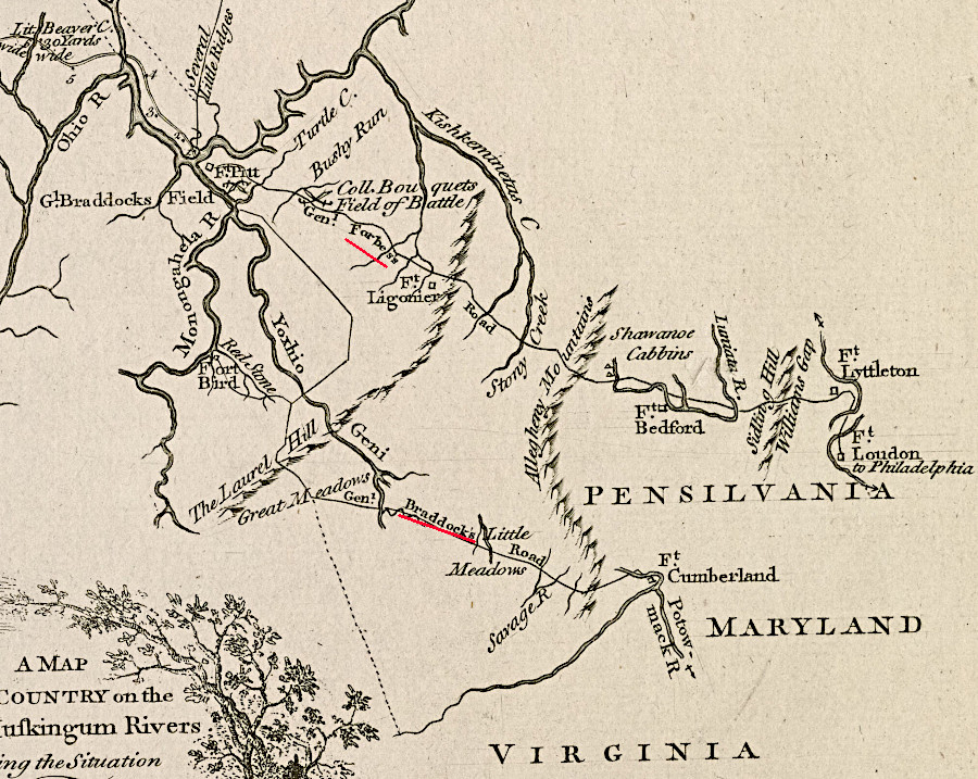
Even worse from the perspective of Virginia colonists, the British decided in 1758 to attack Fort Duquesne by building a different road. General Forbes, the new commander, chose to cut a new route from Philadelphia through the Pennsylvania wilderness. Braddock had brought supplies from Alexandria towards the Monongahela River, but during that expedition had decided that a route through Pennsylvania would be better. Before his death, General Braddock already had ordered a new road to be constructed from Philadelphia to the Youghiogheny River.
By using Philadelphia as his main supply base and building a new road, General Forbes reduced his supply line by 35 miles. It wav easier to get food and forage from Pennsylvania farmers than from Virginia. More importantly for post-war competition between Virginia and Pennsylvania for control of the Ohio Country, the new transportation corridor enhanced the economic link between Philadelphia and the Ohio River.8
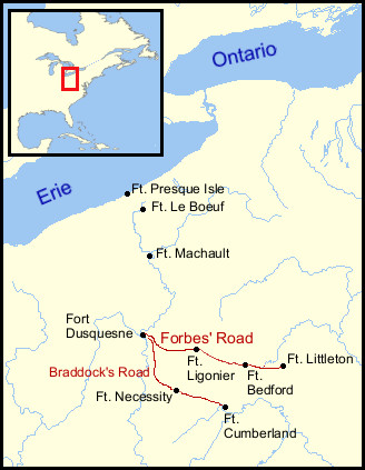
General Forbes abandoned Braddock's Road and built a new, more-direct route to the Forks of the Ohio
Source: Wikipedia, Forbes Road; Norman B. Leventhal Map & Education Center, Boston Public Library, map of the country on the Ohio and Muskingum Rivers (by Thomas Hutchins, 1768)
As war progressed, the French in Canada gradually exhausted their stockpile of supplies. The Royal Navy controlled the seas in the 1750's, and the French could no longer ship essential material from France to Canada. The French no longer had guns, gunpowder, and clothing that were traditionally provided to Native American allies. From the Native American perspective, the war revealed by 1758 that the British could meet their needs and the French could not.
Starting in 1756, the Iroquois negotiated terms for switching Native American allegiances towards the British. An October 1758 treaty signed at Easton, Pennsylvania, ended most support for the French based in Canada. That agreement removed essential support for the French as General Forbes was marching towards Fort Duquesne.
In the Easton treaty, the British said they would constrain colonial settlement of the Ohio River watershed. The Iroquois, Delaware, Mingo, and Shawnee needed supplies in the short term. In the long term, they needed to stop the intrusion of settlers that disrupted their towns and limited success in the hunting grounds around the Ohio River. The 1758 treaty indicated that it would be British policy to block settlement of western lands in order to minimize conflict with Native American tribes.
In 1758 General Forbes marched slowly with 6,000 men toward Fort Duquesne. He carefully established supply bases and avoided any possibility of being defeated like General Braddock. A rash subordinate, Major James Grant, ignored that approach and turned a reconnoitering expedition into an assault on the French fort. Grant's planned ambush on September 14 turned into a disaster in which 300 of his 800 men were killed or captured, including Grant himself.
Forbes continued to march gradually west. On October 12, 1758, French and Native Americans attacked the British who were guarding the horses grazing west of the newest base called Loyalhanna. Forbes was planning to winter there and attack Fort Duquesne in 1759. The British retreated safely into the fortifications. Building a fort rather than racing to attack Fort Duquesne demonstrated the benefits of Forbes' cautious strategy. George Washington assumed the campaign would not restart until 1758; "nothing but a miracle can procure success."
A month later on November 12, 500 members of the Second Virginia Regiment led by Lieutenant Colonel George Mercer engaged in a firefight with a scouting party of 50 Canadian, Shawnee, and Delaware warriors near the fortifications. Captain François-Marie Le Marchand de Lignery had sent them from Fort Duquesne to destroy supplies and stop Forbes' advance. George Washington led a second detachment of Virginia troops from Loyalhanna to assist Mercer's force.
The two Virginia forces ended up shooting at each other as the sun was setting. George Washington, at great personal risk, ran between the lines and pushed rifle barrels away with his sword in order to stop the friendly fire. There were 16 killed and 20 wounded in the incident. Afterwards, Forbes renamed Loyalhanna as Fort Ligonier after the top commander of the British Army back on London.
During the skirmish on November 12, the British captured an Englishman. To avoid being hanged as a traitor, he revealed that Fort Duquesne had few French troops or Native Americans still supporting it. The Treaty of Easton had succeeded in peeling away the essential support of the Iroquois and of other tribes over which the Iroquois claimed authority. Forbes quickly revised his plan and marched directly towards the Ohio River.
Because the Native Americans had left Fort Duquesne, the French commander decided he could not defend it against a siege. When Captain Lignery learned of Forbes' approach, he chose to abandon the French fort. He sent some of his troops north and other troops south down the Ohio River, then blew up the fortifications.
George Washington was allowed to lead the advance brigade when the British marched into the ruins of Fort Duquesne on November 25, 1758. He then resigned his commission and returned to Mount Vernon. He did not hear the whine of bullets in battle again until 1775. During his most important battle in the American Revolution, the victory at Yorktown in 1781, he was allied with the French and they were firing bullets at British soldiers commanded by Lord Cornwallis.
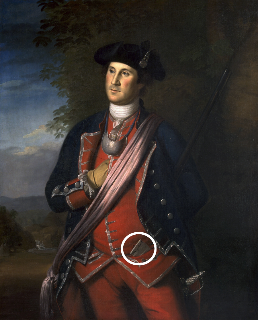
In 1772, when Washington had Charles Wilson Peale paint his portrait, he dressed in his 1758 Virginia Regiment uniform. He put the "Order of March" to Fort Duquesne in his waistcoat pocket for the artist to portray.
British forces captured Quebec in 1759, then Montreal in 1760. When the Governor of New France, Pierre-Rigaud de Vaudreuil, surrendered Montreal he also surrendered all forts in the Mississippi River watershed still remaining in French hands. Without the ability to get supplies from Montreal, France's western forts were doomed. British forces marched west to Fort Michilimackinac and Fort Pontchartrain du Detroit. The French commanders surrendered peacefully and Great Britain gained control of the Mississippi River watershed.9
In the 1763 peace treaty ending the war, the French ceded all their claims in North America to the British except for two small islands needed to support fishing at the mouth of the St. Lawrence River. The French had finally been expelled from all the western lands claimed by the colony of Virginia in its 1609 charter.
Canada had never been a prosperous colony for France. In the Treaty of Paris, France prioritized regaining control of Caribbean sugar islands rather than retaining control of Canada. In his book Candide, Voltaire illustrated the perspective in Paris:10
You know that these two nations are at war for a few acres of snow in Canada, and that they spend over this beautiful war much more than Canada is worth.
After the British captured Fort Duquesne, they renamed it Fort Pitt. Native Americans discovered that the British would not be as generous as the French who had been forced out of Canada, and it was no longer possible to play one European power off another in order to obtain manufactured goods upon which they had grown dependent. The British had conquered the French but not the Native Americans. The failure to maintain the level of "presents" gifted to the tribes spurred Pontiac's Rebellion in 1763.
London officials desired to limit the costs of frontier defense in North America. To end Pontiac's Rebellion, they renewed their 1758 promise to constrain colonial settlement in the Ohio River watershed. King George III issued the Proclamation of 1763 that banned settlement west of the Appalachians.
London officials also sought financial support from the American colonies to repay the debt incurred to fight the French:11
Britain borrowed heavily to win the war, such that the national debt nearly doubled from £74 million in 1756 to £133 million in 1763. To ameliorate the situation by covering future military expenditures in the colony, Parliament passed the Sugar Act (1764) which laid duties on certain items imported to America, and the Stamp Act (1765) which taxed nearly all paper in the colonies. Britain expected to collect nearly £10,000 from Virginia alone under the Stamp Act.
However, British attitudes and policy before and after the French and Indian War created colonial resentment. Braddock's disdain of colonials while at the Carlyle House in 1755, and the later refusal to give George Washington a commission in the Regular Army, spurred resentment.
Colonists treated as just lower class members of society recognized that they were at risk of Great Britain adopting abusive policies. John Carlyle complained the British "used us like an enemy country" and the commanding officers treated the Virginians like "the spawn of convicts."
When the French and Indian War started, no one in North America anticipated the American Revolution. By 1763, the Americans had recognized that they were not fully British. British policies could have been different; a revolution could have been avoided or suppressed successfully.
Cultural arrogance was deeply ingrained within the decisonmakers in London. That arrogance and condescension towards the people in 13 colonies became an issue during the French and Indian War. It festered for another decade, until colonists were radicalized to think that being "American" was a better alternative than remaining "British."
In 1774, George Washington helped George Mason write the Fairfax Resolves. The first item was:12
Resolved that this Colony and Dominion of Virginia can not be considered as a conquered Country; and if it was, that the present Inhabitants are the Descendants not of the Conquered, but of the Conquerors.
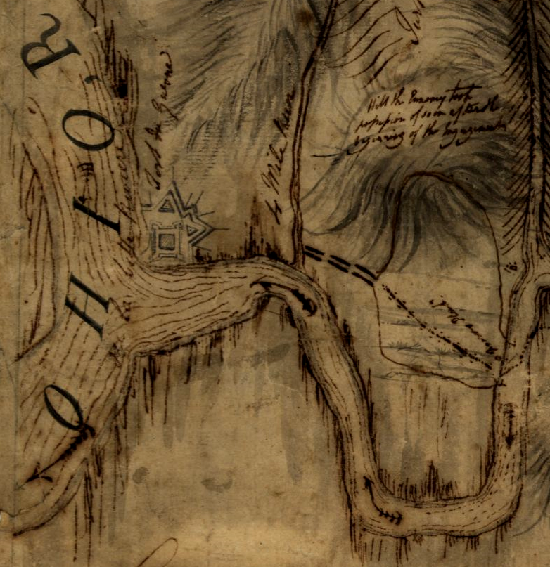
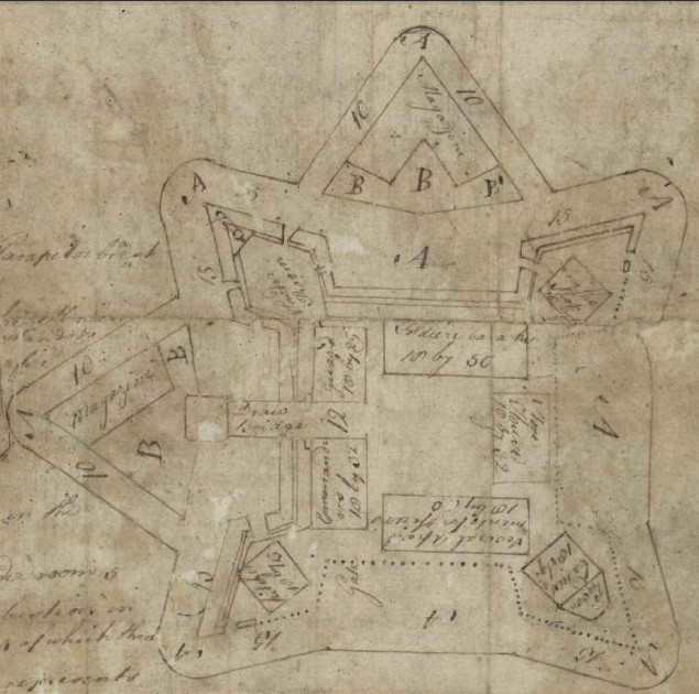
General Braddock knew the details of Fort Duquesne, thanks to a diagram and report smuggled out by an English hostage retained after the surrender of Fort Necessity
Source: University of Pittsburgh, Robert Stobo to Colonel Innes, July 28, 1754
until 1763, the French claimed all of the Mississippi River watershed and asserted English claims stopped at the Alleghenies
Source: David Rumsey Map Collection, English, French and Spanish Possessions (Guillaume de L'Isle, 1718); Library of Congress, Colonial America (1763)