displacing Native Americans and selling lands northwest of the Ohio River were expected to increase the wealth of elite Virginians and their key contacts in Great Britain
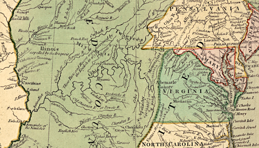
Source: Library of Congress, A trader's map of the Ohio country before 1753 (John Patten, 1753)
The Ohio Company was organized after the 1744 Treaty of Lancaster and the end of the War in 1748 of Jenkin's Ear (known as King George's War in New England and Upstate New York, the American component of the War of the Austrian Succession). The Treaty of Aix-la-Chapelle was silent about French and English claims to the interior of North America, so investors saw an opportunity to obtain western lands.
Ambitious Virginia land speculators had seen large land grants awarded in the Shenandoah Valley and south to the New River. Tens of thousands of acres of low-cost land had been transferred from colonial ownership into private ownership. Since the 1720's, settlers had migrated south from Pennsylvania into the Virginia borderlands west of the Blue Ridge. After the Hudenosaunee (Iroquois) signed the 1744 Treaty of Lancaster, the potential value of the land stretching to the Ohio River increased.1
The right of the colony of Virginia to grant lands in the Ohio River Valley was based on the Second Charter issued by James II to the Virginia Company in 1609. That charter granted to the company all land "from sea to sea, west and northwest." The Ohio Company grant ended up being one of several very large grants approved by the Governor's Council starting in 1730, sometimes after being pressured by British officials in London.
The Ohio Company was a land speculation scheme organized in 1747 primarily by the Thomas Lee family and its allies on the Northern Neck. It sought 500,000 acres between the Allegheny Front and the Ohio River, covering what today is much of West Virginia and Ohio plus western Pennsylvania and Maryland. The 500,000 acre request was the largest grant proposed up to that time.
The investors included members of the Virginia gentry (including two brothers of George Washington), merchants in London with influence at the royal court, and agents living in the backcountry such as Thomas Cresap and his son Daniel. Thomas Lee, prime mover of the Ohio Company, was also a senior member on the Governor's Council. Despite the influential status of the investors, the initial request by the Ohio Company was rejected by Governor Gooch and the Governor's Council on October 20, 1747.
The investors then went over the governor's head. George Mercer represented the company in London as its agent, in a role that today would be called "lobbyist." Prominant merchant John Hanbury, who was an investor, led the successful lobbying effort with the Privy Council for the land grant. Mercer and Hanbury promised the Ohio Company would attract 100 settlers and increase Native American trade for furs, competing with the French for that business.
The Lords Commissioners for Trade and Plantations (Board of Trade) issued instructions to Governor Gooch on March 18, 1749, to sign the paperwork. The Ohio Company land was:2
...to be taken chiefly on the south side of the Ohio, between the Monongahela and Kanawha rivers. Two hundred thousand acres were to be selected immediately, and to be held for ten years free from quit-rents and taxes, on condition that the company should seat one hundred families on the lands within seven years, and build a fort and maintain a garrison sufficient to protect the settlements.
Many of the investors in the Ohio Company also participated in the creation of a new port town on the Potomac River. Alexandria was chartered by the General Assembly in 1749. That port was expected to dominate the increasing trade as the population grew on newly-settled western lands.
After settling the first 200,000 aces, the investors could claim an additional 300,000 acres. The investors hired Christopher Gist as their scout to identify the most valuable lands that should be surveyed. Thomas Cresap started to build a road crossing the Alleghenies towards the Forks of the Ohio, where the Allegheny and Monongahela rivers combine to form the Ohio River. The company built trading posts/forts at Long Meadow, Oldtown, and Will's Creek.
Gist mapped the lands downstream from Shannopin's Town (at the Forks of the Ohio) to the Great Miami River in 1750-1751, and mapped new lands in Kentucky in 1751-1752.3
Getting people to move into the backcountry and occupy the first 200,000 acres required making arrangements with the Native Americans who lived and hunted on the territory south of the Ohio River. Agents for the Ohio Company attracted representatives of different Native American groups to attend a meeting in Logstown in 1752. The company's goal was to confirm the 1744 Treaty of Lancaster with the Haudenosaunee (six Iroquois tribes), and convince the actual residents to allow farmers to take their land.
The Iroquois thought the 1744 Treaty of Lancaster had shifted the boundary of accepted colonial settlement westward from the Blue Ridge to just the southern bank of the Ohio River. The Virginians claimed they had acquired the right to occupy all Iroquois lands west of the Blue Ridge - including lands west of the Ohio River on the north bank, based on the phrase:4
...all the Land within the said the said Colony as it is now or hereafter may be peopled and bounded by his said Majesty our Sovereign Lord the King
Pennsylvania's interpreter Conrad Weiser had visited Logstown in 1748. He found the Shawnee, Delaware and Mingo there were not satisfied with the goods available from the French and were interested in trading with the British. Governor Gooch of Virginia supported the outreach to Logstown, and "Brother Assaraquoa" was thanked as well as the governor of Pennsylvania ("Brother Onas"). The door was opened for trade, but not for settlement.
A later 1748 Treaty of Lancaster between the Pennsylvania colony and the Twightwees (Miamis) had authorized Pennsylvania traders to travel within the Ohio River Valley north of the river. Virginians had not been represented in the Treaty of Lancaster discussions, and the Pennsylvania traders had no desire to see competitors from Virginia doing business with the Native Americans living in towns along the Ohio River valley.
The French were directly opposed to British trade or settlement, whether from Virginia or Pennsylvania. The French cited their long-standing claim to the entire Mississippi River watershed based on the Right of Discovery. René-Robert Cavalier, le Sieur de la Salle, had traveled from Canada to the mouth of the Mississippi River in 1682.
In 1749 Captain Celeron De Bienville led French soldiers down the Ohio River, burying lead plates and claiming the territory in the name of France. The Ohio Company investors assumed the French could be displaced; otherwise their grant from British officials would be valueless.5
The Virginians organized the 1752 meeting with Native American tribes at Logstown to prevent a violent reaction to settlement beyond the south bank of the Ohio River. Commissioners from the Ohio Company, Pennsylvania, and Virginia negotiated the 1752 Logstown Treaty. The Haudenosaunee did not confirm at the 1752 meeting any Virginia ownership of lands that would be sold by the Ohio Company, but were enticed to accept new settlements.
Discussions at Logstown focused on the Mingo headman Tanaghrisson, serving as the Iroquois leader. Tanaghrisson, called the Half King because he was partially empowered by the six Iroquois tribes that composed the Haudenosaunee, agreed in the 1752 treaty to allow the construction of an English blockhouse and trading base on the Ohio River.
His concession ensured the colonists would not shift away from the Haudemosaunee and start negotiating directly with Shawnee and Delaware leaders. Shingas was the Delaware "king," but Tanaghrisson claimed he had crowned Shingas and that the Delaware leader had no independent authority.6
George Croghan was the Pennsylvania representative in the 1752 discussions at Logstown. He was unable to get Pennsylvania's Quaker leaders to confirm a special deal where he could acquire a 200,000-acre grant from the Iroquois. On August 2, 1749 Croghan had gotten three local chiefs to give him that acreage. Croghan asserted that he was entitled to the 200,000-acre claim for the rest of his life, up to the American Revolution in which he sided with the British. He never had enough political influence to get colonial or British officials to acknowledge the legitimacy of his private and undocumented land purchase.
Because Pennsylvania officials rejected Croghan's 200,000 acre claim, during the 1752 treaty negotiations at Logstown the Pennsylvania representative supported Virginia's claim to sovereignty over the Ohio River Valley. That gave Virginia the right to issue land grants to the Ohio Company, according to British law.7
Virginia Governor Robert Dinwiddie directed Captain William Trent to build a fort at the Forks of the Ohio. Construction of Fort Prince George ("Trent's Fort") started in April, 1754. It was not complete when a French force led by Claude-Pierre Pecaudy de Contrecoeur arrived. The French evicted the Virginians and built Fort Duquesne at the Forks.
The French fort was a small facility, not even large enough to house the planned garrison. The earthen walls were sufficient to defend against rifles, but not siege guns. Native Americans who chose to be allies with the French were the primary military capacity at Fort Duquesne.
The first two British attempts to capture Fort Duquesne failed. George Washington marched towards the fort later in 1754, but retreated after fighting a small detachment of French soldiers at Jumonville Glen. French and Indian troops sent from Fort Duquesne intercepted Washington's detachment and forced it to surrender at Fort Necessity. A year later, General Edward Braddock was defeated on the banks of the Monongahela River.
On September 14, 1758, the Native American allies of the French helped defeat the advance guard of General Edwin Forbes' expedition, which was led by Major James Grant. However those allies then left. The French remaining at Fort Duquesne realized they were outnumbered and could not withstand a siege. They destroyed their fort on November 24 and fled.
General Forbes left troops commanded by Hugh Mercer to build a British fort. Mercer constructed a temporary camp known as Mercer's Fort, then built a massive Fort Pitt between 1759-1762.8
The Native Americans abandoned the French in 1758 largely because the Royal Navy had blocked delivey of the trade goods and gifts to Quebec. The British, with no constraints on supplies they could provide, lured the Iroquois and other tribes away from their French alliance. In the 1758 Treaty of Easton, British officials finally got the Delaware to accept promises that no colonists would be allowed to settle west of the Appalachians.
The promises made at the Treaty of Easton reflected the new assertion of imperial authority that replaced the "salutary neglect" policy followed in London until the late 1740's. TStarting in 1755, trade and negotiations with the Native Americans was centralized under the authority of a Superintendent of Native Affairs for the Northern Colonies (William Johnson) and a Superintendent of Native Affairs for the Southern Colonies (John Stuart).
In 1760 the Ohio Company tried to get the colonel in charge of Fort Pitt, Henry Bouquet, to join the land sprculator group. With the British military protection, the Ohio Company expected to attract settlers and sell land.
Bouquet declined, and surprised the investors with a statement that he would enforce the terms of the Treaty of Easton. Bouquet wrote:9
...and tho' the Government of Virgn. and Maryland did not accede to that Treaty, I conceive that they are equally bound by it, and that no settlement will be permitted upon the Ohio till the Consent of the Indians can be procured.
Governor Fauquier failed to get Bouquet to change his opinion. The Ohio Company then sent George Mercer to London to get a directive sent that would override his policy.
However, King George III issued the Proclamation of 1763 that prevented settlement in the territory where the Ohio Company expected to claim its first 200,000 acres. The company's investors were involved with negotiations to relax the prohibition. In the 1768 Treaty of Fort Stanwix, the Haudenosaunee/Iroquois sold the rights to the lands south of the Ohio River, but not to lands north of the river.
Lord Dunmore and the General Assembly tried to assist the land speculators. Virginia's royal governor launched Dunmore's War in 1774, perhaps to enhance the opportunity for members of the colonial elite to acquire land grants.
In the Treaty of Camp Charlotte he got the Shawnee to relinquish their claims south of the Ohio River. However, the insurrection within the colonies graduated into a shooting war in 1775, and the authority of British officials to issue land grants was extinguished by the American Revolution.
There were other land speculators who competed for the same territory. Pennsylvania-based traders and investors formed the Illinois Company, then transformed it into the Indiana Company when they acquired the claims of the "suffering traders." Native Americans had seized the goods of traders at the start of the French and Indian War and later in 1763 during Pontiac's War. Those traders ended up getting Haudenosaunee chiefs to authorize a 200,000 acre land grant just prior to signing the 1768 Treaty of Fort Stanwix.
While trying to get that grant officially confirmed so land could be sold, the suffering traders got involved with other Pennsylvania-based and London-based investors who were seeking land grants. In a confusing series of transactions in which some investors were cut out of the deals, the Indiana Company morphed into the Grand Ohio Company (also known as the Walpole Company).
It had the best connections in the royal court, and ended up proposing to purchase 2,000,000 acres of lands west of Pittsburg and south of the Ohio River. The land would be formed into a new colony called Vandalia. The Ohio Company investors merged into the Grand Ohio Company/Walpole Company, ending up with just two of the 72 shares. The original dream of 500,000 acres was reduced by that arrangement to just 55,000 acres, but that was still a windfall - if the grant could be formalized.
The Vandalia Colony was never finalized, and the British lost the war. The Ohio Company grant and others issued by royal officials to speculative land companies became worthless.10
During the American Revolution, the Virginia General Assembly established two Virginia Military Reserves in the Ohio River watershed to guarantee the state would have enough land to fulfill bounties promised to soldiers willing to enlist. The state also negotiated a deal with Richard Henderson to resolve his claims to Transylvania, but made no such bargain with any of the land companies.
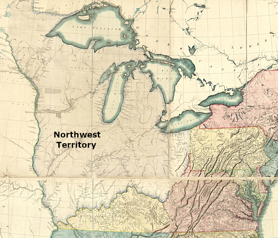
Virginia relinquished its claims to the Northwest Territory in 1784. The Confederation Congress showed little willingness to accommodate the land speculators of the past who had obtained large grants during colonial days, but did sell land to a new group investors (mostly Continenal Army officers from Massachusetts) who named themselves the Ohio Company of Associates.11
The new national government eventually sold most of the public lands in the Northwest Territory to a new bunch of land speculators and to actual settlers. The Confederation Congress also created its own reserve to fulfill land bounties for veterans.
British claims to land on Virginia's western edge were extinguished, a least in theory, by the 1783 Treaty of Paris that ended the American Revolution
Source: Library of Congress, Bowles's new pocket map of the United States of America (Carington Bowles, 1784)