French Colonization After Jamestown
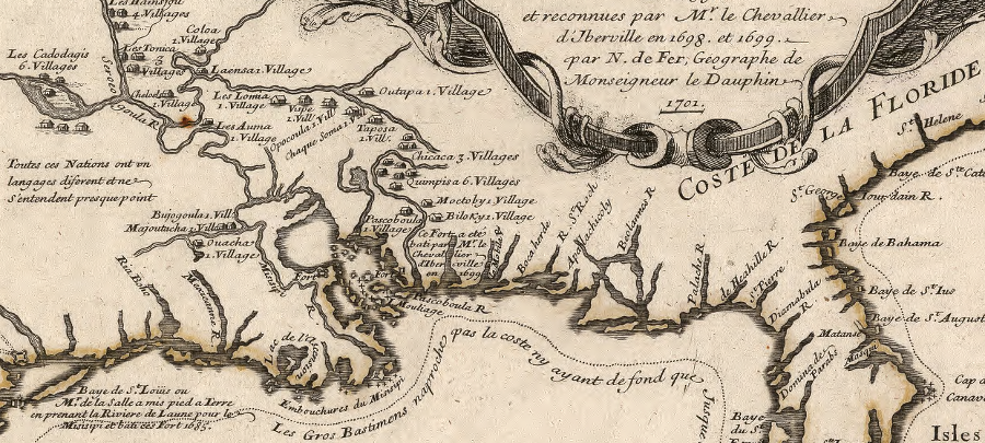
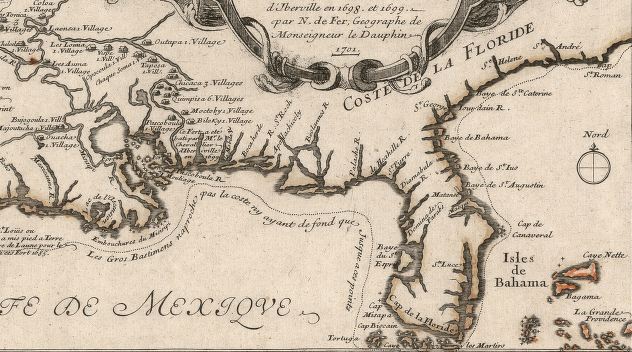
map of Native American villages along the Mississippi River/Gulf Coast, reflecting explorations of Ren -Robert Cavelier, Sieur de La Salle in the 1680's
Source: Library of Congress, Les costes aux environs de la rivi re de Misisipi: d couvertes par Mr. de la Salle en 1683 et reconnues par Mr. le Chevallier d'Iberville en 1698 et 1699
The first French attempt at settlement in the New World was by Jacques Cartier in 1541 on the St. Lawrence River, but it lasted only two years. The French settlement at Charlesfort (1562) collapsed on its own; after a mutiny, the soldiers constructed a boat and sailed back across the Atlantic Ocean. The building of Fort Caroline (1564) in what is now Jacksonville, Florida triggered their rival European nation to respond. The Spanish, led by Pedro Menendez de Aviles, destroyed the French colony and established a base at St. Augustine in 1565.
Until the French created Charlesfort and then Fort Caroline, the Spanish were content to leave North America as claimed but unexplored/unsettled. Ponce de Leon landed in 1513 in what he named Florida, but it took until 1565 to create a permanent Spanish settlement.
The next attempt by the French to settle in North America was made in 1604. King Henry IV granted a monopoly on the fur trade between the 40-46th parallels of latitude to Sieur de Mons, and he led a group that settled first on an island in the Saint Croix River. Half of them died in the first winter, suffering from scurvy. The remainder, including Samuel de Champlain, moved in 1605 to the coastline of the Bay of Fundy on the west side of what today is called Nova Scotia.
The French created a settlement in 1605 which they called Port-Royal. It was the first successful European colony north of St. Augustine in Florida; all the English attempts in the 1580's had failed. The French settlers briefly abandoned Port-Royal when the king revoked the fur monopoly of Sieur de Mons, but then returned in 1610.
In 1608 Samuel de Champlain established Quebec, and that community has survived to this day.
That same year, the Spanish began their second permanent settlement in what today is the United States by starting Santa Fe in New Mexico. Like St. Augustine and Santa Fe in New Mexico - and unlike Jamestown - Quebec has survived to the present day. Despite the transfer of authority to the English in 1759 after the Conquest (known as the French and Indian War in the English colonies to the south), the culture of Quebec has remained persistently French.
French expansion beyond Port Royal was initiated by conflict between Jesuits and Huguenots. Father Pierre Biard and three other Jesuit priests, with about 40 other Frenchmen, left Port Royal and sailed south towards the Penobscot River. They ended up landing on Mount Desert Island, or nearby on what is now called Frenchman Bay. Their original settlement, called Saint Sauveur, may have been at Southwest Harbor next to Acadia National Park.
That French colony, in what today is Maine, lasted only three months. It suffered the same fate as Fort Caroline in Florida; North American representatives of France's European enemies destroyed it.
The Virginia Company was responsible for the end of Saint Sauveur. The English company, with its settlement at Jamestown, protected its claim to territory granted by King James I by expelling European rivals.
The English had chosen to settle in 1607 at a location far north of Spanish-occupied Florida, hoping that the distance would deter Spain from attacking Jamestown. The French at Port Royal and Saint Sauveur had settled far outside the boundaries of Virginia as defined in the Third Charter (1612), but the French were not so lucky with the English.
Samuel Argall had sailed north, after capturing Pocahontas in a visit to the Patawomeck tribe and delivering her to Jamestown, to fish for cod. He learned from the Wabanaki that the French:1
- ...had just begun to build a fort, plant corn, and baptize the natives when an English ship commanded by Captain Samuel Argall destroyed their mission.
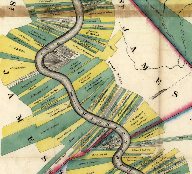
if Virginia had been settled by the French, land would have been surveyed in "arpents" with each settler provided river access though long and narrow lots (as was done in Louisiana)
Source: Library of Congress, Norman's chart of the lower Mississippi River, by A. Persac
After Argall took control over Saint Sauveur, he lacked room in his ship for all of the new captives. Most of the French colonists were allowed to sail back to France, but two Jesuits priests were carried back to Jamestown.
Argall brought those two priests with him when he sailed north from Virginia on a second expedition in 1613. He found and destroyed the French settlement that had been re-started at Port Royal in 1610.
On his return to Jamestown, a storm blew Argall's ship east into the Atlantic Ocean. He landed at the Azores and then sailed on to England. The Jesuit priests that had been captured at Saint Sauveur had been taken to Jamestown, brought north again to Port Royal/St. Croix, diverted to the Azores, and then carried to England. From there, the two well-traveled priests were returned safely to France.2
Acadia was contested land for many decades. In 1621 King James I of Great Britain issued a grant to William Alexander for what the French called Acadia. The English king renamed it Nova Scotia ("New Scotland"). Alexander built Fort Anne around 1629, but negotiators in Europe returned the site to French control in 1632. In the same treaty, the French regained control over Quebec. It had been seized by English privateer David Kirke in 1629.3
The French strategy for settling Canada, the Gulf Coast, and the Mississippi River watershed was to create trading stations to acquire furs from Native Americans, and to support French shipping. A small number of French Catholics living in New France were expected to acquire resources and create wealth for sponsors back in Europe.
The French settlement strategy was similar to the Spanish approach; both relied upon local Native Americans to supply the colonies. The Spanish Law of the Indies in 1573 detailed a planned settlement pattern that was based on religious missions, military presidios, and civilian pueblos. Neither Spain nor France snt a large number of colonists to the New World.
Getting colonists to go to Quebec, and to stay alive there, was challenging. Winters were cold, there was no gold or silver to acquire, and the fur trade was not profitable for many. Samuel de Champlain brought his wife to Quebec in 1620, but the isolated colony was not attractive and she returned to France in 1624.
When Champlain died in 1635 at Quebec, there were only 200 French colonists in North America. Seven decades after the French started to settle in Quebec, there were still less than 8,000 French living in Canada. The population increased to 62,000 by 1755. That was far below the population growth in the 13 English colonies to the south, which had around 1.2 million colonists in 1755.4
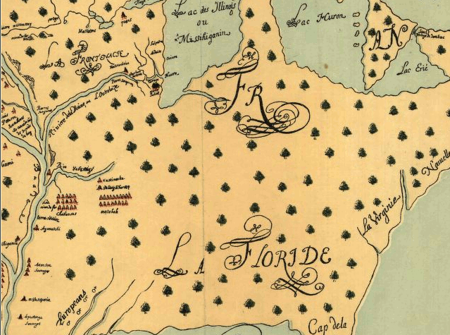
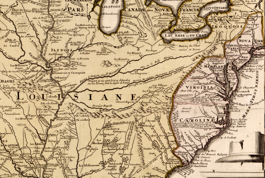
the French expected the Ohio and Mississippi rivers to provide a water-based corridor for linking colonies in Louisiana and Quebec
Map Source: Library of Congress, This map of North America, according to ye newest and most exact observations (1715)
The first Europeans to travel through the Illinois country were adventurous French explorers, Catholic priests, and fur traders. French expeditions westward from Montreal into the interior of North America expanded much faster than English efforts. In 1654, when colonization in Virginia was just expanding west of the Fall Line into the Piedmont, French fur trader Medard Chouart, Sieur Des Groseilliers was traveling around the Great Lakes. In 1659-1660, he journeyed with his brother-in-law Pierre Esprit Radisson to what is now Wisconsin and Minnesota.
In 1669 Rene-Robert Cavelier, Sieur de La Salle, reached Lake Erie. He had organized an expedition with no knowledge of how to travel through the backcountry or engage with the local Native Americans. The only result of that trip was the education La Salle received in survival. In 1673, he traveled west again and reached Lake Ontario. There he obtained approval from the local tribes to build Fort Frontenac.5
In 1673 Father Jacques Marquette and Louis Joliet crossed from Lake Michigan to the Mississippi River, then canoed downstream to the Arkansas River. After determining that the Mississippi River provided a water highway from the Great Lakes to the Gulf Of Mexico, they turned back to avoid being captured by any Spanish ships sailing around the Caribbean.
Coming into the Mississippi River watershed from the north, Frenchmen walked, rafted, and canoed westward from Quebec and Montreal on the St. Lawrence River to trade with Native American groups. From the south, French explorers moved up from the Gulf of Mexico.
In 1680 Ren-Robert Cavelier, Sieur de La Salle led an expedition on the Illinois River south to the site of modern Peoria, Illinois. He built Fort Crèvecoeur there. The French explored the area before the English, pronunciation of the name of the state of Illinois (Ill-ee-noy) is based on the French rather than the English language (Ill-ee-noise).6
La Salle envisioned creating a chain of trading posts along the Mississippi River expanding New France to the west. In 1677 he had obtained the rights from French officials in Paris to explore all the lands between Florida and Mexico. In 1683 he led a expedition of French and Native Americans down the Illinois River to its confluence with the Mississippi River, and traveled further south to the site of modern-day Memphis. They build Fort Prud'homme there, then traveled to the mouth of the Mississippi River and buried a metal plate claiming the watershed as part of New France. La Salle named the territory Louisiana in honor of King Louis XIV.
On that expedition the French constructed Fort Saint Louis de Rocher on the Illinois River, as part of their effort to control the fur trade with various Native American nations who might otherwise deal with the English in New York.
In 1685 La Salle sailed on a ship from France to find the mouth of the Mississippi River. He overshot his target, landing eventually at Matagorda Bay on the Texas coast. La Salle died while still seeking the river's mouth.
In 1699 Louis XIV sent two brothers, Pierre Le Moyne d'Iberville and Jean-Baptiste Le Moyne de Bienville, to establish a settlement near the mouth of the river but far enough upstream to be safe from attack by the Spanish. New Orleans was founded in 1718, at a location which controlled all trade coming down the Mississippi River. France or Spain controlled New Orleans and threatened to throttle the economic potential of American farmers settling in the Mississippi River watershed until the Louisiana Purchase in 1803.7
A variety of French officials and entrepreneurs explored widely across the North American continent. The use of French as an official language in Quebec, the Napoleonic legal code of Louisiana, and the pattern of land survey in Louisiana are modern indicators of the French government's colonial successes in creating New France in the New World.
Source: Library of Congress, Carte du Canada ou de la Nouvelle France et des decouvertes qui y ont été faites (1718)
In the mid-1600's the English finally became alarmed at the expansion of French influence in North America westward from Quebec. French fur traders were effective in creating alliances with Native American tribes in the Mississippi River watershed, and those tribes were capable of blocking efforts to settle in Virginia west of the Blue Ridge.
the English produced maps that designed to counter the French perspective and extend Virginia westward
Source: Norman B. Leventhal Map & Education Center, A new map of the north parts of America claimed by France (by Herman Moll, 1720); Library of Congress, A new and exact map of the dominions of the King of Great Britain on ye continent of North America (by Herman Moll, 1731-32); A map of the British and French dominions in North America (John Mitchell, 1755); An accurate map of North America (Emanuel Bowen, 1755); Norman B. Leventhal Map & Education Center, An accurate map of North America (Emanuel Bowen, 1763)
It took Virginia officials over 60 years after reaching Jamestown to get to the crest of the Blue Ridge. The French discovered the geography of the Ohio River watershed, and made contact with the Native Americans living there, before the Virginia colonists became familiar with the Shenandoah River watershed. Governor Berkeley finally sent John Lederer across the Virginia Piedmont in 1670. Alexander Spotswood was the first Virginia governor to cross the Blue Ridge, traveling with the Knights of the Golden Horseshoe expedition in 1718.
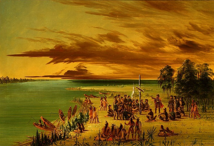
the French claimed Louisiana by Right of Discovery, in part thanks to La Salle's explorations in 1682, and sold it to the United States in 1803
Source: National Gallery of Art, La Salle Claiming Louisiana for France. April 9, 1682 (by George Catlin)
Exploration by La Salle and others allowed French leaders back in Europe to claim wide parts of North America by the "Right of Discovery." However, France did not invest heavily in sending people to North America to build towns or to finance creation of a new society in the St. Lawrence River or Ohio River valleys.
French traders chose instead to operate in the backcountry through Native American allies. Their main trading posts were Montreal and Quebec, with forts in the backcountry to steer Native Americans with furs and deerskins to the St. Lawrence River.
Frenchmen lived in Native American towns, establishing families, learning the languages, and creating alliances. Priests sought to create converts, but the French adopted the lifestyle of the Native Americans. Around the Great Lakes in particular, the French were able to cultivate the "middle ground" between Native and European cultures.
the French established trading posts between Montreal and the Mississippi River, but did not send large numbers of colonists to New France
Source: Wikipedia, New France
The French government minimized the development costs of New France. Profits were expected to flow to France without substantial investment in the lands on the other side of the Atlantic Ocean.
French kings initially created proprietary colonies, granting seigneur rights to land in exchange for recruiting colonists. Permanent settlement started after 1603, when Henry IV gave Pierre Du Gua de Monts a 10-year monopoly over the fur trade between the 40-46th parallels, roughly from the mouth of the Delaware River north to the mouth of the St. Lawrence River.
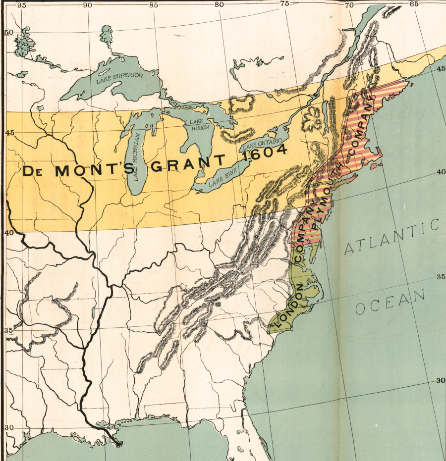
if the French had won the French and Indian War in 1763, the 1604 grant to de Monts might have shaped the boundaries of the United States
Source: Library of Congress, The comprehensive series, historical-geographical maps of the United States - Early land grants (1919)
During the first 50 years of colonization, the French failed to establish colonies on the Atlantic seaboard south of the Saint Lawrence River. The created only a minimal presence on the Gulf Coast and in the Mississippi River valley, and were slow to expand the population of settlements on Nova Scotia and in the St. Lawrence River watershed.
Immigration from France to the settlements on the St. Lawrence River was limited to Catholics. Religious restrictions were looser for colonization efforts at Charlesfort and Fort Caroline in the 1560's, but a century later King Louis XIV repressed French Protestants (Huguenots) as he created a centralized state.
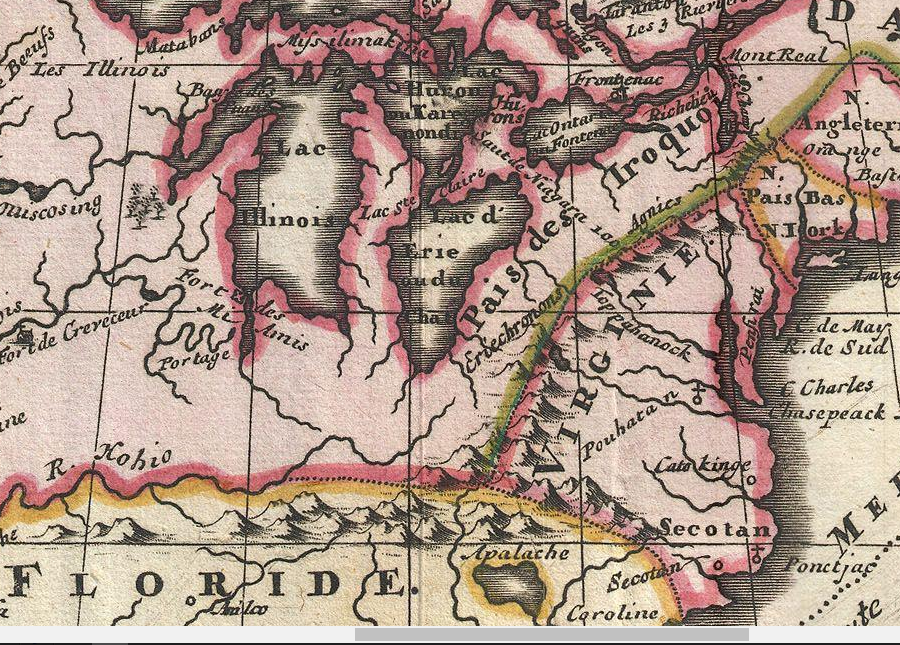
![the Erie - N[ation] du Chat - occupied the lands between Lake Erie and the English colony of Virginia](graphics/sanson.gif)
the Erie - N[ation] du Chat - occupied the lands between Lake Erie and the English colony of Virginia
Source: Library of Congress, Am rique septentrionale (by Nicolas Sanson, 1650)
There were still less than 100 French settlers at Quebec in 1627 when Cardinal Richelieu consolidated different entrepreneurial initiatives into the Compagnie de la Nouvelle France (Company of One Hundred Associates). That charter was revoked in 1663.
After 1663, Louis XIV retained ownership of land in New France (Canada) and simply licensed its use. There were only 3,500 French "habitants" in New France along the St. Lawrence River in 1663, in contrast to the 90,000 settlers in the English and Dutch colonies to the south.8
Louis Joliet's 1674 map of large New France dominating land south of Great Lakes, and tiny Virginia constrained to Atlantic coastline
Source: Library of Congress, Joliet's map, 1674
The English strategy for control of North America was to flood the colony with Protestant immigrants who would be loyal to England in any fight with Spain/France, even if those immigrants were not Anglicans. The British crown did not finance that immigration. Many of the colonists were transported across the Atlantic Ocean at their own expense, which was often paid through a commitment to provide labor as an indentured servant for up to seven years.
The other key group of immigrants were slaves. Investors, rather than the British Crown, funded their transport to the New World.
English immigration into North America was slow in the first 20 years after Jamestown was settled in 1607. Religious conflicts in England triggered a great migration between 1630-1660, in which the English colonial population far surpassed the number of colonists in New France:9
- During those three decades, about 220,000 persons left England, a full 4% of that country's 5,500,000 inhabitants: 47,500 to the Chesapeake, 28,900 to New England, 113,600 to the Caribbean or Bermuda, and 30,000 to Ireland or Holland...
- By raising the number of English on the North American mainland from 4,200 in 1630 to more than 70,000 by 1660, this sudden surge of humanity created a critical mass of Anglo-Saxons, far more numerous than could be expelled by their French and Spanish rivals for empire in North America and so ensured the ultimate success of British colonization.
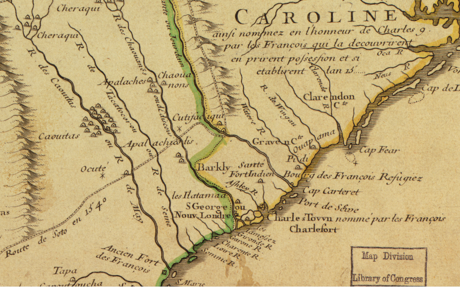
in 1718 French cartographer Guillaume De L'Isle highlighted the 1562 French settlement of Charlesfort on the Carolina coastline, though Charles Town was named in 1670 by the English settlers to honor King Charles II of England rather than King Charles IX of France
Source: Library of Congress, Carte de la Louisiane et du cours du Mississippi (1718)
Immigrants from France and England disrupted Native American societies from the beginning, but North America was a huge place. It absorbed colonists from rival European countries for many decades before those groups found themselves seeking to occupy the same territory. At one point Virginians even sought to recruit French Protestants, Huguenots fleeing after revocation of the toleration granted by the Edict of Nantes. French settlers planning to immigrate into North Carolina were diverted to an old Monacan town on the James River, which became known as Manakin.
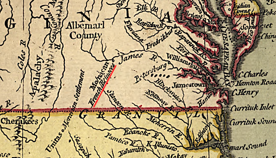
Huguenots were settled at Manakin, upstream of the Falls of the James
Source: A New and Accurate Map of North America (Carington Bowles, 1771)
It took about 250 years after Columbus discovered the New World for the international rivalry between France and England to affect Virginia. When the French finally threatened Virginia, the danger came from the Ohio River rather than from warships raiding the Atlantic Ocean coastline.
map of Native American villages along the Mississippi River/Gulf Coast, reflecting explorations of Rene-Robert Cavelier, Sieur de La Salle in the 1680's
Source: Library of Congress, Les costes aux environs de la riviere de Misisipi:
decouvertes par Mr. de la Salle en 1683 et reconnues par Mr. le Chevallier d'Iberville en 1698 et 1699
In the 1600's and 1700's, French officials had created numerous trading stations around the Great Lakes and in the Ohio River/Mississippi River watersheds. The "forts" enhanced the fur-trading business with different Native American groups, and gifts from French officials resulted in pledges of loyalty from different tribes.
French officials claimed the entire Mississippi River watershed as part of Louisiana, including the Ohio River and Tennessee River tributaries
Source: Library of Congress, A Map of Louisiana and of the River Mississippi (John Senex, 1721)
Resolution of French and English war in Europe with the 1713 Treaty of Utrecht ending the War of the Spanish Succession and the 1748 Treaty of Aix-le-Chappelle failed to reconcile which nation would control the lands west of the Allegheny Mountains in North America. In 1713 the English gained control of Nova Scotia/Acadia, Newfoundland, and Prince Rupert's Land around Hudson Bay (owned by the Hudson's Bay Company until 1870), but the French retained most of Canada. In addition to Quebec and Montreal, the French continued to control Cape Breton Island and were able to build the fortress of Louisbourg there.
The 1748 Treaty of Aix-le-Chappelle ended the War of the Austrian Succession in Europe. Fighting in North America had started in 1739 with the War of Jenkins's Ear, and between 1744-48 was known on the western side of the Atlantic Ocean as King George's War. The British, including American colonists, managed to capture Louisbourg. However, in the Treaty of Aix-la-Chapelle the fortress was returned to the French as part of a trade for French-captured territory in India.10
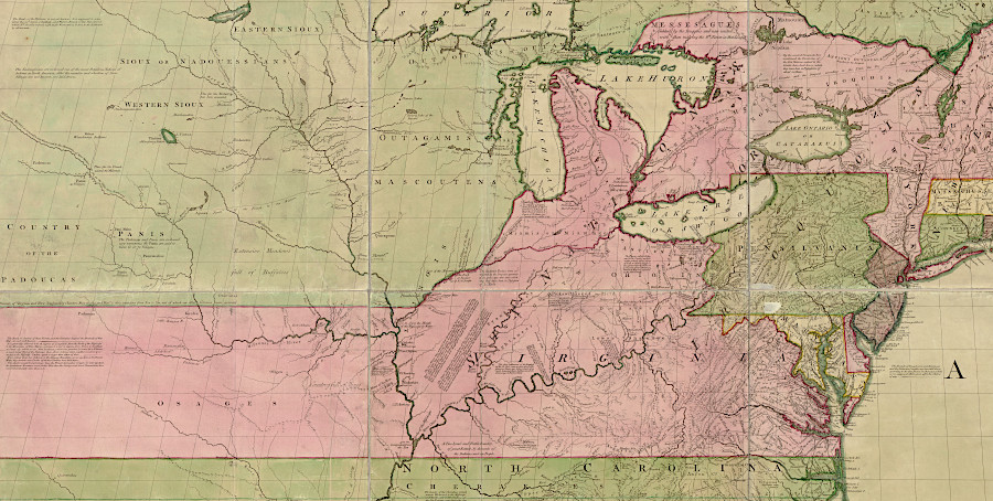
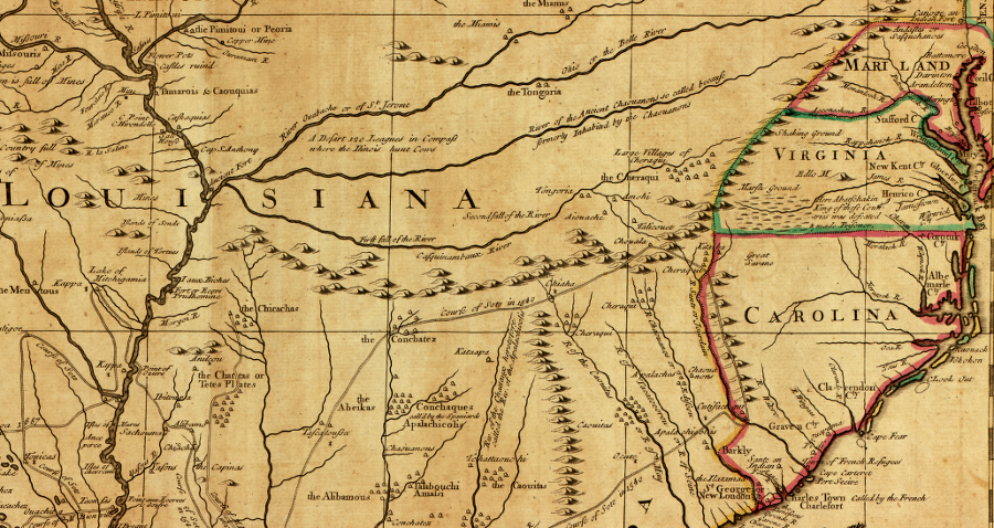
French cartographers emphasized French land claims to the Ohio River and Mississippi River valleys
Source: Library of Congress, Novissima tabula regionis Lvdovicianae gallice dictae La Lovgsiane iam olim quidem sub Canadae et Floridae nomine in America Septentrionali (Guillaume de L'Isle, 1716)
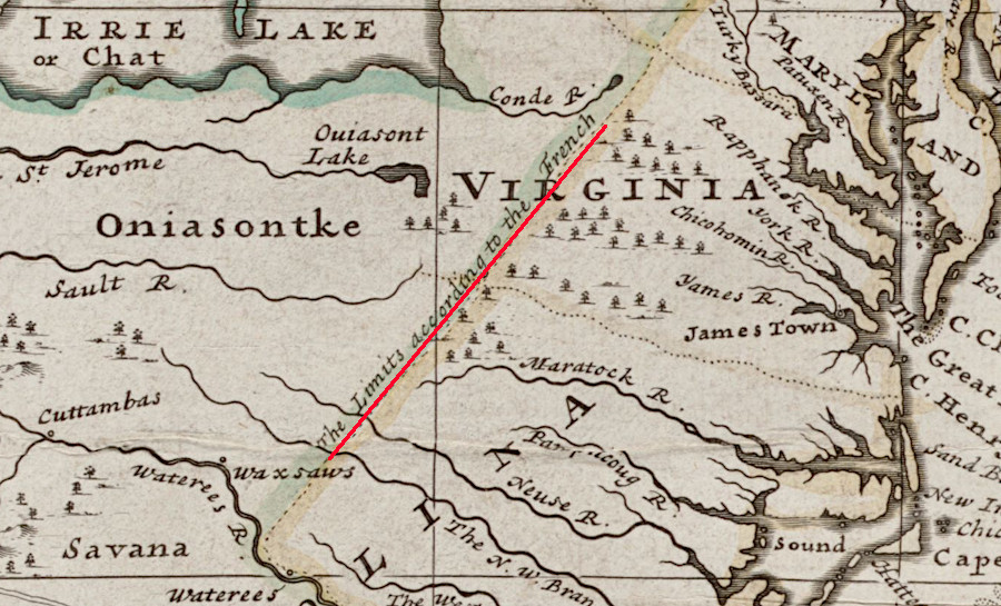
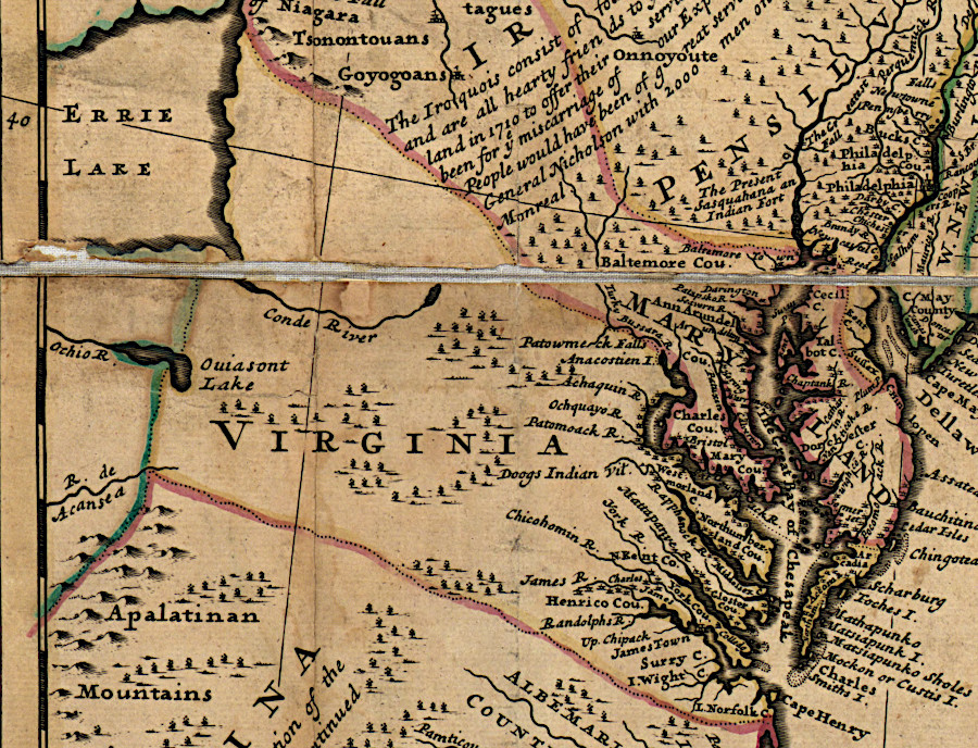
While in office in 1710-1722, Virginia's Governor Spotswood feared the French and/or their Native American allies would move south from Lake Erie into the Potomac River watershed. He and his replacement, Governor Gooch, encouraged immigration of Scotch-Irish and German settlers to the Shenandoah Valley and further south. The maps of the day suggested the French on Lake Erie could quickly march to the Blue Ridge.
Lake Erie was thought to be close to the Blue Ridge in the early 1700's
Source: Wikipedia, Antoine Hennepin's colorized map of North America (Friar Hennepin, 1698)
Those governors wanted to build a buffer of loyal-to-Virginia colonists on the western side of the Blue Ridge, following the example of Gov. Frances Nicholson in 1700. When King William III sent Huguenot refugees to Virginia, Gov. Nicholson ignored the king's direct instructions to settle them in the Norfolk area. He placed them instead on the James River above the Fall Line, at the site of a deserted Monacan village that became known as Manakin Town.
French and English disputed ownership of lands west of the Allegheny Front, and Virginia's governors feared the French might attack settlers in the valleys west of the Blue Ridge
Source: Wikipedia, French and Indian War
The settlers who crossed the Potomac River and walked up the Shenandoah Valley in the 1730's and 1740's were not Anglicans. Many did not even speak English; the immigrants were often German-speaking refugees fleeing the constant warfare in Europe.
The newcomers were different, but still welcome. The presumption in Williamsburg was that if land was provided by Virginia officials, then the new settlers would be dependent upon the colonial government and would serve as a barrier against expansion of French influence.
James Patton successfully used that argument to obtain his Woods River Grant. The Governor's Council rejected his initial request in 1743, saying it:11
- ...might occasion a Dispute betwixt them and the French, who claimed a Right to Land on those waters.
However, in 1744 France and England ended up on opposite sides in the War of the Austrian Succession. Concerns about irritating the French and triggering conflict were surpassed by an actual open war. In addition, the Haudenosaunee (Iroquois) signed the Treaty of Lancaster in 1744. They abandoned their claims to the lands along the New, Holston, and Clinch rivers where Patton sought a land grant.
Patton was granted 100,000 acres in 1745, with the possibility of receiving an additional 100,000 acres.12
The Virginians competed with more than the French and the Native Americans for control of western lands. Throughout the 1740's, Pennsylvania traders competed with Native Americans for the fur trade (particularly deerskins) with French traders based on the St. Lawrence River. The British offered higher-quality guns, clothing, and other goods. Factories in England were more efficient, and English ships could transport manufactured items at a lower cost across the Atlantic Ocean. During King George's War (1744-1748), the Royal Navy blocked French ships from supplying Canada.
Native Americans grew frustrated with France as British traders set up operations in towns within the Ohio River Valley. Different factions of the Shawnee, Delaware, and Mingo were recruited to attack rival traders, as Montreal-based and Philadelphia-based traders sought to block competition. Conrad Weiser and George Croghan were the primary representatives of the Pennsylvania traders in the 1740's.
In 1747, one group sent the scalp of a French trader to Governor Palmer of Pennsylvania as a sign it wanted to increase business with the British. Palmer recruited the governors of Maryland and Pennsylvania to arrange a meeting and provide gifts, which was a fundamental beginning when negotiating with the tribes. The assemblage gathered at Logstown, a trading post on the Ohio River downstream from the Forks of the Ohio. Discussions began on September 1, 1748.13
Control of western land was a key part of the Virginia gentry's strategy for getting and staying rich. The gentry created new syndicates to extend land speculation westward across the Allegheny mountains into the Ohio River watershed.
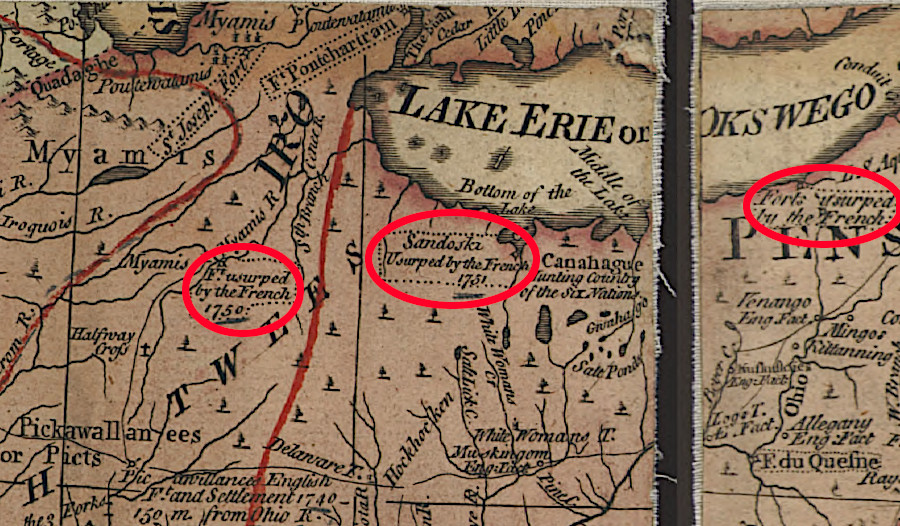
The French responded to the land claims of the Virginians. Officials in Quebec sent military expeditions down the Ohio River to assert control over that land and to maintain trade with the Mingo, Shawnee, Delaware, and other resident tribes.
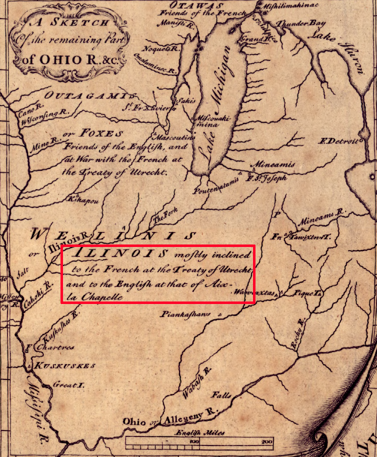
resolution of French and English wars in Europe with the 1713 Treaty of Utrecht and the 1748 Treaty of Aix-le-Chappelle failed to reconcile which nation would control the lands west of the Allegheny Mountains in North America, but the 1763 Treaty of Paris ending the Seven Years War (French and Indian War) ended French efforts to occupy the Ohio River valley and the Upper Mississippi
Source: Library of Congress, A general map of the middle British colonies, in America (Lewis Evans, 1755)
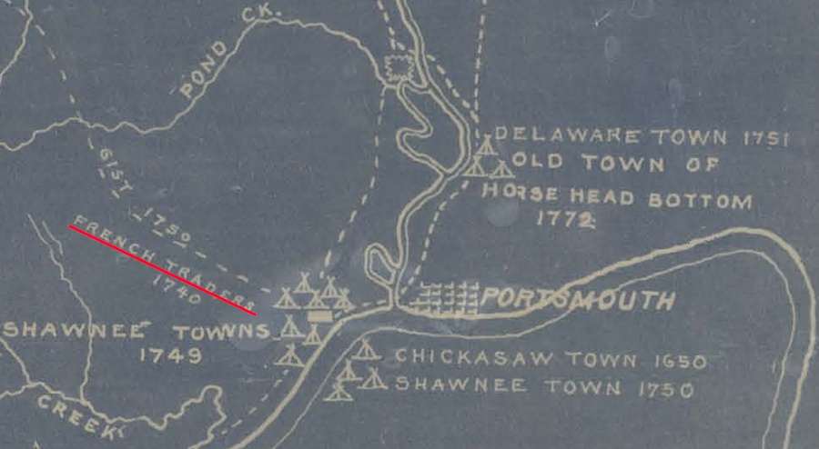
French traders were active on the Ohio River in 1740
Source: Cincinnati Public Library, A map of the Indian towns, villages, camps and trails in the Virginia Military District and south-western Ohio (Richard G. Lewis, 1902)
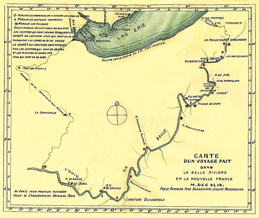
Pierre Joseph Celoron de Blainville led a French expedition down the Ohio River in 1749 to deter Native Americans from trading with the British
Source: Wikipedia, Logstown
When the French built forts at Presque Isle (now Erie), LeBeouff (now Waterford), and Venango (now Franklin) in 1752, Virginia's Governor Dinwiddie sent George Washington to direct them to leave. Washington's visit in the winter of 1753 failed to intimidate the French. In 1754 Governor Dinwiddie sent William Trent with an advance guard of colonial troops to build a Virginia fort at the Forks of the Ohio.
The French sent a military expedition downriver and seized Fort Prince George ("Trent's Fort"). At the time, Washington was leading a body of men to reinforce Trent at the fort. He arrived too late and his expedition ended in disaster. With his Native America allies he attacked a small number of French troops at Jumonville Glen, but quickly retreated and built a palisade for protection.
Washington was inexperienced and his quickly-built Fort Necessity was poorly located. It survived only one day under attack. In the surrender document, Washington admitted to "assassinating" the French ambassador at Jumonville Glen, perhaps due to a misunderstood translation from French into English.
The English responded by sending two regiments to North America under General Edward Braddock. In 1755, his expedition to recapture the fort also ended in disaster.
The conflict in the Ohio River territory claimed by Virginia sparked the Seven Years War in Europe. The Acadians living in Nova Scotia refused to fight for England and were considered to be a potential threat, so the English deported them. Ships with Acadians were sent to Virginia, but colonial officials there refused to accept the refugees and they were redirected to England. Some of the expelled Acadian colonists were sent to Louisiana, where the "Cajun" (Acadian) culture developed a distinct identity.14
The French were unable to send enough ships and troops to defend their claims in North America. In 1758 the Native Americans who provided the primary military capacity at Fort Duquesne abandoned the French. They burned the fort and fled in both directions along the Ohio River. The British then built Fort Pitt on the site.
15
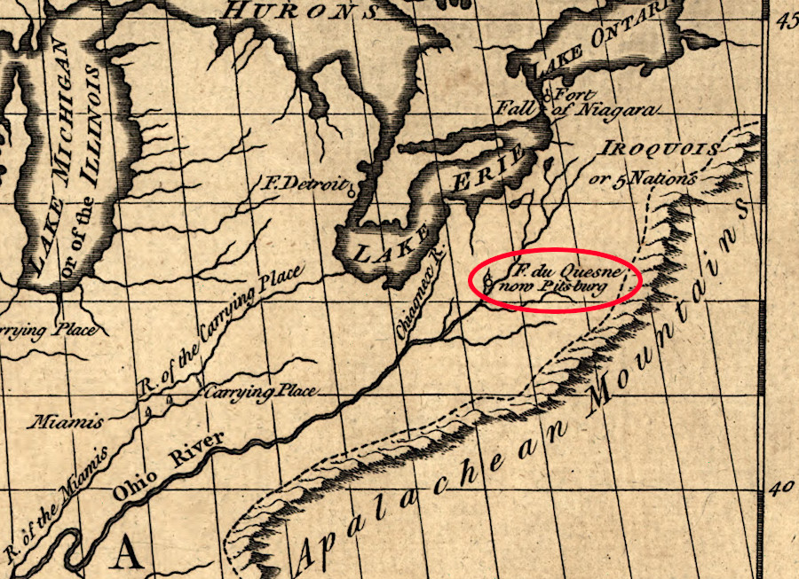
the French abandoned Fort Duquesne in 1758, and the British constructed Fort Pitt at the Forks of the Ohio
Source: Library of Congress, A map of Louisiana, with the course of the Missisipi, and the adjacent rivers, the nations of the natives, the French establishments and the mines (by Le Page du Pratz, 1775)
In 1759 the great fortress at Quebec was captured. Montreal surrendered in 1760. French efforts to occupy the Ohio River valley and the Upper Mississippi were blocked, and Great Britain achieved political/military authority over North America north of Florida and east of the Mississippi River.
The Treaty of Paris in 1763 formally ended what the Europeans called the "Seven Years War," and the English colonists in North America Virginians called the "French and Indian War." In Quebec, it became known as "The Conquest" because France surrendered its claims to almost all of Canada ("a few acres of snow"). Great Britain took control over Quebec and all lands claimed by France in Canada except for two small islands at the mouth of the St. Lawrence River, the islands of Saint Pierre and Miquelon.16
Actual control by the British after 1763 was effective only in areas where Native American tribes had been displaced. The legal claim according to European custom was constrained by the presence of powerful tribes between the Alleghenies and the Mississippi River, including the Creek, Choctaw, Chickasaw, Cherokee, Shawnee, Erie, Miami, Kickapoo, and Mingo.
The English successfully sought to placate the conquered French colonists by allowing them to retain French civil law in Quebec, ensuring land claims would not be challenged. The English also allowed the colonists to retain their Roman Catholic religion and institutions, and no longer required officeholders to affirm they were Protestants according to the Test Act.
The 1774 Quebec Act granted enough local control to the Quebecois that when the American colonies rebelled against Great Britain in 1775, the Canadians did not join the American Revolution and accept the invitation to become a 14th state.17
In 1762, France transferred its rights to the Louisiana Territory to Spain in order to keep the British from acquiring it. Spain gained control over a vast estate in North America, expanding upon its claims based on occupation of Mexico.
The Virginia government claimed the Northwest Territory until it relinquished control to the national government organized under the Articles of Confederation. Until the Northwest Territory was ceded, Virginia and Illinois County officials had to deal with French settlers in towns like Kaskaskia along the Mississippi River and Vincennes on the Wabash River. Those settlers feared their land would be seized by unscrupulous people using Virginia warrants to acquire property, or attempting to acquire parcels by preemption (simply occupying it, then later legalizing ownership).
The General Assembly passed a bill in October 1779 than banned new settlement north of the Ohio River, but specifically mentioned that the French and Canadians who had already occupied land near forts were considered to be legitimate. The 1784 Deed of Cession to the Confederation Congress included:18
- ...the French and Canadian inhabitants, and other settlers of the Kaskaskies, St. Vincents, and the neighboring villages who have professed themselves citizens of Virginia, shall have their possessions and titles confirmed to them, and be protected in the enjoyment of their rights and liberties.
The records of land grants inherited from French and British officials were incomplete and often fraudulent. Appointed officials representing Virginia and then the national government did not have the authority to confirm or revise land grants, leaving settlers in a state of unease. The US Congress finally passed legislation on December 6, 1790 to clarify the legitimacy of claims established by 1783. The Act for Granting Lands to the Inhabitants and Settlers at Vincennes and the Illinois County also authorized the territorial governor to issue 400-acre land grants to families who had resided in the territory by 1783.19
In the Third Treaty of San Ildefonso (1800), Spain transferred the Louisiana Territory back to France after Napoleon established French control over Spain in the First Empire. Following the successful revolt in Haiti, Napoleon decided to abandon France's imperial ambitions in North America. He arranged for the sale of the Louisiana Territory to the United States of America, ending French land claims to territory that is now part of the United States.20
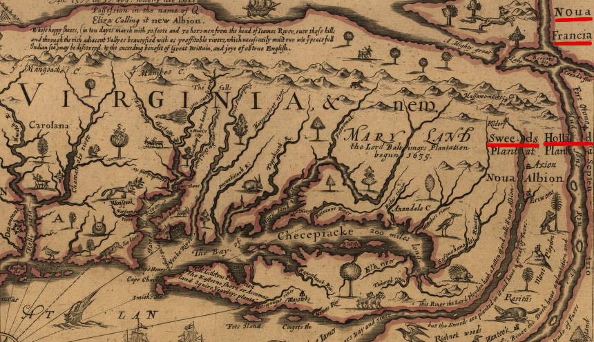
the French, Dutch, and Swedes were all competitors for colonizing lands between the Chesapeake Bay and Lake Ontario
Source: Library of Congress, A mapp of Virginia discovered to ye hills (by John Farrer, 1667)
Links
- American Archeology
- Archeology
- Canada's Historic Places
- Canadian Museum of History
- Creighton University
- Library of Congress
- National Park Service
- Newberry Library
- University of South Carolina
- University of South Florida
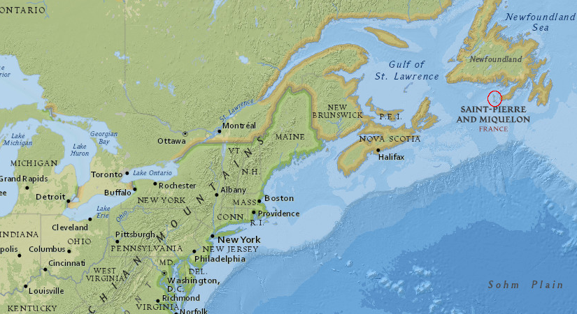
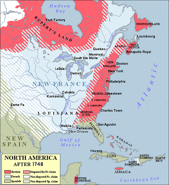
after the end of the French and Indian War, France retained control of only two islands (Saint Pierre and Miquelon) in North America
Source: ESRI, ArcGIS Online
References
1. "St. Saveur: A Meeting of Nations," Abbe Museum, https://www.abbemuseum.org/exhibits/2021/5/12/st-saveur-a-meeting-of-nations-2013-2016; "St. Sauveur mission, Mount Desert, ca. 1866," Maine Memory Network, https://www.mainememory.net/record/100356; Tim Garrity, "Real and Imagined France in Acadia National Park," National Park Service, https://npshistory.com/publications/acad/c-v18-2017.pdf; "History of Québec City," Quebec Citie, https://www.quebec-cite.com/en/quebec-city/history-quebec; "History: Port-Royal National Historic Site," Parks Canada, https://parks.canada.ca/lhn-nhs/ns/portroyal/culture/histoire-history (last checked October 14, 2025)
2. Reuben Gold Thwaites (editor), The Jesuit Relations: Volume 4 and Allied Documents, Travels and Explorations of the Jesuit Missionaries in New France 1610 1791, The Burrows Brothers, 1898, p.29, p.49. p.61, p.67, http://puffin.creighton.edu/jesuit/relations/relations_04.html; W. Austin Squires, "Argall (Argoll), Sir Samuel," in Dictionary of Canadian Biography, vol. 1, University of Toronto/Université Laval, 2003 , http://www.biographi.ca/en/bio/argall_samuel_1E.html (last checked July 2, 2014)
3. "Port Royal (Annapolis Royal) - Victim of intermittent wars between two empires," Acadie, https://acadie.cheminsdelafrancophonie.org/en/port-royal-annapolis-royal-victim-of-intermittent-wars-between-two-empires/ (last checked July 3, 2025)
4. Andro Linklater, Measuring America: How an Untamed Wilderness Shaped the United States and Fulfilled the Promise of Democracy, Walker and Company, NY, 2003, p.42, https://www.google.com/books/edition/Measuring_America/eqFPEAAAQBAJ; "Samuel de Champlain," EBSCO, https://www.ebsco.com/research-starters/biography/samuel-de-champlain; Robert V. Wells, "The Population of England's Colonies in America: Old English or New Americans?," Population Studies, Volume 46, Number 1 (March, 1992), p.90, https://www.jstor.org/stable/2174707; Gregory Evans Dowd, War Under Heaven: Pontiac, the Indian Nations & the British Empire, Johns Hopkins University Press, 2002, p.26, https://www.google.com/books/edition/War_under_Heaven/w8IKAAAACAAJ (last checked December 3, 2025)
5. "The Explorers: René-Robert Cavelier de La Salle 1670-1687," Virtual Museum of New France, Canadian Museum of History, https://www.historymuseum.ca/virtual-museum-of-new-france/the-explorers/rene-robert-cavelier-de-la-salle-1670-1687/ (last checked June 30, 2025)
6. "Fort Crèvecoeur, a 1680 French-Peoria Agreement," La Grande Louisiane Francais, a href"https://louisiane.cheminsdelafrancophonie.org/en/fort-crevecoeur-an-agreement-between-french-and-peorias-in-1680/">https://louisiane.cheminsdelafrancophonie.org/en/fort-crevecoeur-an-agreement-between-french-and-peorias-in-1680 (last checked January 24 2026)
7. "Radisson, Pierre Esprit (1636/1640–1710)," MNopedia, https://www.mnopedia.org/person/radisson-pierre-esprit-16361640-1710; Warren Hofstra, "Backcountry Frontier of Colonial Virginia," Encyclopedia Virginia, Virginia Humanities, December 7, 2020, https://encyclopediavirginia.org/entries/backcountry-frontier-of-colonial-virginia/; "Expedition of Marquette and Joliet, 1673," Wisconsin Historical Society, https://www.wisconsinhistory.org/Records/Article/CS520; "René Robert Cavelier, Sieur de La Salle: Life and Explorations," Texas Historical Society, August 3, 2020, https://www.tshaonline.org/handbook/entries/la-salle-rene-robert-cavelier-sieur-de; "The La Salle Expedition: A Journey into the Unknown," Texas State Historical Association, June 12, 2024, https://www.tshaonline.org/handbook/entries/la-salle-expedition; "The Founding of New Orleans," American Battlefield Trust, https://www.battlefields.org/learn/articles/founding-new-orleans;"The Explorers: René-Robert Cavelier de La Salle 1670-1687," Virtual Museum of New France, Canadian Museum of History, https://www.historymuseum.ca/virtual-museum-of-new-france/the-explorers/rene-robert-cavelier-de-la-salle-1670-1687/; "The History of Illinois' Fort St. Louis du Rocher (aka: Rock Fort) on Starved Rock," Digital Research Library of Illinois History, https://drloihjournal.blogspot.com/2018/07/history-of-illinois-fort-saint-louis-du-rocher.html; "Cavelier De La Salle, Rene-Robert," Dictionary of Canadian Biography, https://www.biographi.ca/en/bio/cavelier_de_la_salle_rene_robert_1E.html (last checked May 27, 2025)
8. "Champlain Anniversary Timeline," CBC News Online, March 5, 2004, http://www.cbc.ca/news2/background/champlainanniversary/timeline.html; Marcel Trudel, "Champlain, Samuel de," Dictionary of Canadian Biography, Volume 1, University of Toronto/Université Laval, 2003 , http://www.biographi.ca/en/bio/champlain_samuel_de_1E.html; Louis H. Roper, Bertrand Van Ruymbeke, Constructing Early Modern Empires: Proprietary Ventures in the Atlantic World, 1500-1750, Brill, 2007, pp.119-123, https://books.google.com/books?id=Yn7XCAVIqbMC (last checked August 2, 2015)
9. Thomas L. Purvis, Colonial America To 1763, Facts on File, 1999, p.163, https://books.google.com/books?id=BZRJS
10. "Treaty of Utrecht," The Canadian Encyclopedia, https://www.thecanadianencyclopedia.ca/en/article/treaty-of-utrecht; "War of the Austrian Succession," The Canadian Encyclopedia, https://www.thecanadianencyclopedia.ca/en/article/war-of-the-austrian-succession; "Rupert's Land," The Canadian Encyclopedia, https://www.thecanadianencyclopedia.ca/en/article/ruperts-land (last checked January 26, 2025)
11. Otis K. Rice, The Allegheny Frontier: West Virginia Beginnings, 1730–1830,, University Press of Kentucky, 1970, pp.16, pp.19-20, p.33, https://core.ac.uk/download/pdf/232566066.pdf; Ryan S. Mays, "The Draper's Meadows Settlement (1746-1756) Part II," The Smithfield Review, Volume 19 (2025), https://vtechworks.lib.vt.edu/server/api/core/bitstreams/c193fe2c-0ff2-4285-98be-7a25fd2a17b5/content (last checked October 15, 2025)
12. "James Patton (Virginia colonist)," Wikiwand, https://www.wikiwand.com/en/articles/James_Patton_(Virginia_colonist); Otis K. Rice, The Allegheny Frontier: West Virginia Beginnings, 1730–1830,, University Press of Kentucky, 1970, pp.16, pp.19-20, p.33, https://core.ac.uk/download/pdf/232566066.pdf (last checked October 15, 2025)
13. Gregory Evans Dowd, War Under Heaven: Pontiac, the Indian Nations & the British Empire, Johns Hopkins University Press, 2002, p.27, https://www.google.com/books/edition/War_under_Heaven/w8IKAAAACAAJ (last checked December 3, 2025)
14. Dr. Don Landry, "The Ships of the Acadian Expulsion," Acadian-Cajun Genealogy and History, http://www.acadian-cajun.com/landryships.htm; Charles I. Landis, "Captain William Trent, an Indian Trader," https://www.lancasterhistory.org/images/stories/JournalArticles/vol23no10pp173_183_524318.pdf (last checked July 12, 2025)
15. "Turning the Tide - the British Capture of Fort Duquesne," The Cultural Experience, https://www.theculturalexperience.com/news/turning-the-tide-the-british-capture-of-fort-duquesne/ (last checked July 10, 2025)
16. "The French and Indian War (1754-1763): Its Consequences," American Battlefield Trust, https://www.battlefields.org/learn/articles/french-and-indian-war-1754-1763-its-consequences, "Why Voltaire mocked Canada as ‘a few acres of snow’?," Books on Trial, https://www.booksontrial.com/voltaire-mocked-canada-acres-snow/ (last checked October 14, 2025)
17. "Canada and the American Revolution," Museum of the American Revolution, https://www.amrevmuseum.org/canada-and-the-american-revolution; "Quebec Act, 1774," The Canadian Encyclopedia, https://www.thecanadianencyclopedia.ca/en/article/quebec-act (last checked January 26, 2025)
18. "An Act for more Effectually Securing to the Officers and Soldiers of the Virginia line, the lands reserved to them, for discouraging present settlements on the north west side of the Ohio river, and for punishing persons attempting to prevent the execution of land office warrants," Military Bounty Warrants 1779, Kentucky Secretary of State, https://www.sos.ky.gov/land/resources/legislation/Documents/Military%20Bounty%20Warrants%201779.pdf; "Virginia Deed of Cession," March 1, 1784, Indiana Historical Bureau, https://www.in.gov/history/about-indiana-history-and-trivia/explore-indiana-history-by-topic/indiana-documents-leading-to-statehood/the-virginia-cession/ (last checked July 10, 2025)
19. "Act for Granting Lands to the Inhabitants and Settlers at Vincennes and the Illinois County," Duke University, https://exhibits.library.duke.edu/exhibits/show/lincoln/item/12175; "To George Washington from Winthrop Sargent, 31 July 1790," Founders Online, National Archives, https://founders.archives.gov/documents/Washington/05-06-02-0070 (last checked July 10, 2025)
20. "Spanish Colonial Louisiana," 64 Parishes, https://64parishes.org/entry/spanish-colonial-louisiana-adaptation; "Third Treaty of San Ildefonso," 64 Parishes, https://64parishes.org/entry/third-treaty-of-san-ildefonso (last checked January 26, 2025)
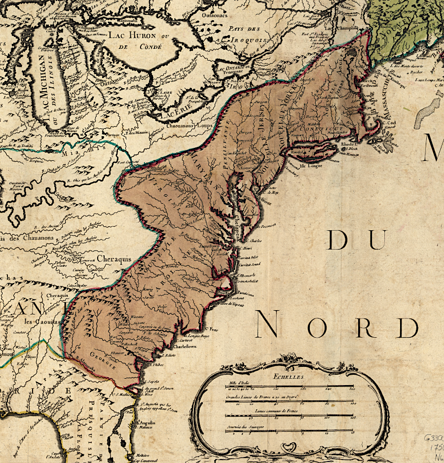
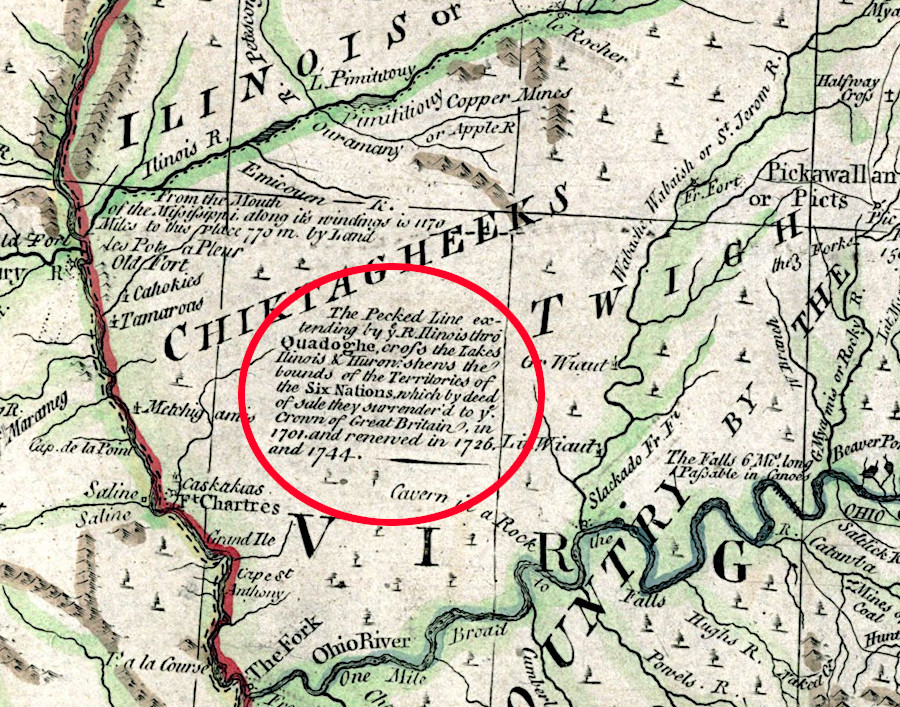
the French claim to the watersheds of the Ohio and Mississippi Rivers was abandoned in 1763
Source: Library of Congress, Carte du Canada et de la Louisiane qui forment la Nouvelle France et des colonies angloises ou sont representez les pays contestez (by Jean Baptiste Nolin, 1756)
Exploring Land, Settling Frontiers
Virginia Places