Woods River Grant
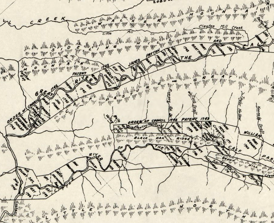
land patents acquired in the 1740's on the Little Calfpasture River and Calfpasture River, showing selection of flat bottomland good for farming rather than steep hillsides
Source: Library of Congress, Colonial land patents and grantees: Calfpasture Rivers, Augusta County, Virginia (by Meredith Leitch, 1947)
James Patton orchestrated a land grant to the Woods River Company as settlers occupied the grants further north already awarded to Benjamin Beverley and James Borden. Patton, along with John Lewis, had recruited immigrants from Ireland and Pennsylvania to settle on those grants in the 1730's. They recruited 32 families to settle there, meeting the requirement established by the Governor's Council in Williamsburg that each settler qualified for awarding 1,000 acres.
Lewis and Patton also partnered to get a 10,500 acre grant on the Calfpasture River in 1743 with an additional 16,500 acres added a year later.
Jame Patton requested a 200,000 acres grant in 1743, possibly as an individual rather than in the name of the Woods River Company. That company name was used only briefly by Patton in the mid-1740's. It is not clear if there were any other investors in the Woods River Company.
The 1743 grant application was the first commitment to attract settlers into the watershed of the New River, which had previously been called the Woods River. Patton sent John Buchanan to survey the area. The area became more attractive as the Haudenosaunee (Iroquois) relinquished their claim to lands betweeen the Blue Ridge and the Allegheny Front in the 1744 Treaty of Lancaster.
The treaty guaranteed the Iroquois could travel through the Valley and Ridge province, in order to exchange visits with the Tuscarora still in eastern Carolina and to raid the Catawba/Cherokee in western North Carolina. The designated pathway crossed the New River near modern-day Radford.
In 1745, as other land companies sought grants to lands west of the Blue Ridge, the Governor's Council in Williamsburg authorized a 100,000 acre grant to Patton. In 1748 the area in which Patton could claim land was expanded from the New River Valley to include the headwaters of the Tennessee River, the valleys of the Holston, Clinch, and Powell rivers south of the New River watershed divide. Patton was required in 1748 to survey the tracts which he planned to claim.1
The Woods River Grant was not intended to be one large, 100,000 acre tract. Instead, multiple large tracts were to be surveyed which, together, totaled 100,000 acres. Within the initial tracts that composed the 100,000 acre grant to Patton, later surveys would define the metes and bounds of smaller parcels which Patton would sell to settlers for their personal farms.
Requiring Patton to survey his tracts was intended to enable later claimants to know what lands were still available. They could mark off boundaries for their own tracts without creating a conflict. Otherwise, when surveys of tracts within a grant's area were filed in Williamsburg to qualify for a patent, a rival claimant could enter a "caveat." A dispute over the validity of a survey would delay issuance of patents by the governor, sometimes for decades.
In theory, Patton and others with land grants were required to define tracts with rectangular-like boundaries that were no more than three times longer than they were wide. That geographic requirement was intended to prevent early claimants from appropriating all the high-quality farmland soils on river floodplains and leaving just low-quality hillsides for later arrivals. In practice, surveys were shaped so they managed to lock up as much of the good farmland as possible.2
James Patton, born in Ireland, may have smuggled untaxed tobacco by ship from the Chesapeake Bay to England in the 1730's. He established a business relationship with William Beverley from Blandfield Plantation in Essex County. Beverley became a member of the House of Burgesses in 1736, and had obtained a 60,000 acre grant in the Shenandoah Valley surrounding modern-day Staunton.
Beverley needed settlers to purchase individual farms that would be surveyed out of his 30,000 acre grant. He sought John Lewis's assistance in recruiting Irish immigrants, and in 1737 offered Patton 25% of the grant in exchange for recruiting enough buyers:3
- I should be very glad if you could import families enough to take the whole off from our hands at a reasonable price and tho' the order mentions families from Pensilvania, yet families from Ireland will do as well.
While Beverley chose to partner with James Patton, his peers in the shipping business considered him to be untrustworthy. Patton and his major business partner in Scotland apparently smuggled tobacco without paying the required fees. Patton shortchanged his partner as he prepared to move permanently to Virginia. The partner, who evidently could not seek justice because of his own involvement in smuggling, wrote about Patton:4
- ...its not in the power of my pen to sett forth the wickedness & impudence of that man.
Patton made his last trip across the Atlantic Ocean in 1740. By 1741, he was living on the Beverly Manor grant south of Staunton. He became an investor in the James and Roanoke River Company and ended up controlling its 100,000 acre land grant. Patton also served as a justice of the peace for Augusta County when it was organized in 1745 and commander of the county militia, and was a leader in the new Tinkling Springs Presbyterian congregation - where he quarreled with John Lewis.
While his dealings with shipowners may have been shady, his actions on the borderlands fit the pattern of other land speculators seeking to acquire wealth through acquiring land. Colonial policy in Williamsburg matched personal agendas west of the Blue Ridge, because attracting new residents would increase the number of men who could secure the land for Virginia.
He did not shrink from interpersonal conflict:5
- He was litigious, dominated county politics, and gave no quarter to Indians, his pastor, or his former associates. Patton was instrumental in settling western Virginia, but he was not the stuff of which popular heroes are made.
In 1743, Patton requested a 200,000 acre land grant on the "Western Waters," within the Mississippi River watershed. The Governor's Council feared such a grant would initiate a response from the French who claimed ownership of the entire watershed through prior Right of Discovery.
The council replied to Patton that it had rejected the request:6
- ...as the distance was so great from any Part of the Alantick Ocean, They could not conceive that any Benifit could arise to his Majesties Revenues or to the strength of this Colony by a handfull of Poor People that might Venture to settle there.
In 1745, Governor's Council changed its mind. It granted 100,000 acres to Patton and indicated he might also receive another 100,000 acres. This was the first grant in the Mississippi River watershed, in conflict with French claims.
For his Woods River Company, later renamed the New River Company, Patton had to select lands that were not within the boundaries of the area claimed by Lord Fairfax, Benjamin Borden, or William Beverley. He located many of his 100,000 acres on the New River, but some surveys were completed on the Calfpasture River west of the Beverley Manor grant and the Borden Grant ("Irish Tract").
In 1744, Patton had signed the Treaty of Lancaster. He located the surveys for his grant on either side of the "Great Road" through the New River.
Patton's first surveyor was John Buchanan. He was replaced in 1751 by Patton's nephew William Preston, who surveyed the parcels sold at Draper's Meadows on the New River. Governor Dinwiddie issued a patent for 7,500 acres there on June 20, 1753, allowing Patton to sell the individual parcels surveyed by Preston to 18 different settlers in early 1754. Patton paid the colonial government 37 pounds 10 shillings for property that he sold for 701 pounds 7 shillings, a handsome profit.
The Draper's Meadow survey was incorrect; it actually included nearly 10,000 acres. Both the Ohio Company and the Loyal Land Company objected by entering "caveats" to some of the Woods River Company surveys, since those companies claimed the rights to the same area.
The Woods River Grant did not initiate the French and Indian War; George Washington triggered it with his attack at Jumonville Glen in 1754. At the time, Colonel James Patton was county lieutenant of Augusta County and in charge of the militia. Patton brought a supply of gunpowder from Williamsburg to the backcountry in July, 1755.
Most of the 100,000 acre Woods River Grant acres were surveyed and patented before the outbreak of the American Revolution.7
Starting in the 1730's, Patton had allied with William Beverley and John Lewis. Lewis and Patton recruited settlers from Ireland to Beverley Manor, enabling William Beverley to gain ownership of 118,118,491 acres in what became Augusta County. In 1737, he and John Lewis requested to purchase parcels west of the Blue Ridge on the Calfpasture River.
In 1743 he asked the Governor's Council for a 200,000 acres of land grant. He was awarded 100,000 acres, with the potential of receiving another 100,000 acres later, and organized the Woods River Company to survey and sell his land along the New, Holston, and Clinch rivers. The Woods River Company was later renamed the New River Company.
Patton was a key leader in the Tinkling Spring Presbyterian Church and Augusta County government, but he quarreled with other land speculators. The Loyal Land Company sued to restrict his ability to survey parcels on land that syndicate claimed. The Ohio Company helped to block his 1753 effort to obtain an additional 100,000 acres.
The potential to attract settlers south to the Woods River Grant was increased when some Iroquois chiefs signed the Treaty of Logstown in 1752. The treaty affirmed the cession of the Woods River Grant territory, but the full tribal leadership did not ratify the treaty before the outbreak of the French and Indian War.
Patton was killed at Draper's Meadows on the New River when the Shawnee attacked on July 30, 1755. The New River Company did not remain active after his death.8
Links
References
1. "James Patton (Virginia colonist)," Wikiwand, https://www.wikiwand.com/en/articles/James_Patton_(Virginia_colonist); Otis K. Rice, The Allegheny Frontier: West Virginia Beginnings, 1730–1830,, University Press of Kentucky, 1970, pp.16, pp.19-20, p.33, https://core.ac.uk/download/pdf/232566066.pdf; Ryan S. Mays, "The Draper's Meadows Settlement (1746-1756) Part II," The Smithfield Review, Volume 19 (2025), https://vtechworks.lib.vt.edu/server/api/core/bitstreams/c193fe2c-0ff2-4285-98be-7a25fd2a17b5/content (last checked January 17, 2026)
2. William D. Bennett, "Early Settlement Along the New River (NC and VA) Basin," in Proceedings, New River Gorge Symposium, 1984, https://npshistory.com/series/symposia/new_river/sec3.htm (last checked January 17, 2026)
3. Donald W. Gunter, "James Patton," Dictionary of Virginia Biography, https://old.lva.virginia.gov/public/dvb/bio.asp?b=Patton_James (last checked January 14, 2026)
4. Donald W. Gunter, "James Patton," Dictionary of Virginia Biography, https://old.lva.virginia.gov/public/dvb/bio.asp?b=Patton_James; Jim Glanville and Ryan Mays, "The Mysterious Origins of James Patton. Part 1," Smithfield Review, Volume 15 (2011), http://www.holstonia.net/files/PattonPart1.pdf (last checked January 14, 2026)
5. Donald W. Gunter, "James Patton," Dictionary of Virginia Biography, https://old.lva.virginia.gov/public/dvb/bio.asp?b=Patton_James; "Treaty of Lancaster," Envisaging the West: Thomas Jefferson and the Roots of Lewis and Clark, University of Virginia and the University of Nebraska, https://jeffersonswest.unl.edu/archive/view_doc_jef.00083.html; Jim Glanville and Ryan Mays, "The Mysterious Origins of James Patton. Part 1," Smithfield Review, Volume 15 (2011), http://www.holstonia.net/files/PattonPart1.pdf (last checked January 14, 2026)
6. Ryans S. Mays, "The Draper's Meadows Settlement, (1746-1756) Part II," Smithfield Review, Volume 19 (2015), p.18, https://vtechworks.lib.vt.edu/server/api/core/bitstreams/c193fe2c-0ff2-4285-98be-7a25fd2a17b5/content (last checked January 14, 2026)
7. Ryans S. Mays, "The Draper's Meadows Settlement, (1746-1756) Part II," Smithfield Review, Volume 19 (2015), pp.3-6, https://vtechworks.lib.vt.edu/server/api/core/bitstreams/c193fe2c-0ff2-4285-98be-7a25fd2a17b5/content; Donald W. Gunter, "James Patton," Dictionary of Virginia Biography, https://old.lva.virginia.gov/public/dvb/bio.asp?b=Patton_James; Ed March, post on Facebook group "Blacksburg, Memories of the Way We Were," April 4, 2026, https://www.facebook.com/share/p/1DMzfoR4MS/ (last checked April 5, 2026)
8. Ryans S. Mays, "The Draper's Meadows Settlement, (1746-1756) Part II," Smithfield Review, Volume 19 (2015), pp.3-6, https://vtechworks.lib.vt.edu/server/api/core/bitstreams/c193fe2c-0ff2-4285-98be-7a25fd2a17b5/content; Donald W. Gunter, "James Patton," Dictionary of Virginia Biography, https://old.lva.virginia.gov/public/dvb/bio.asp?b=Patton_James (last checked January 14, 2026)
Exploring Land, Settling Frontiers
Virginia Places