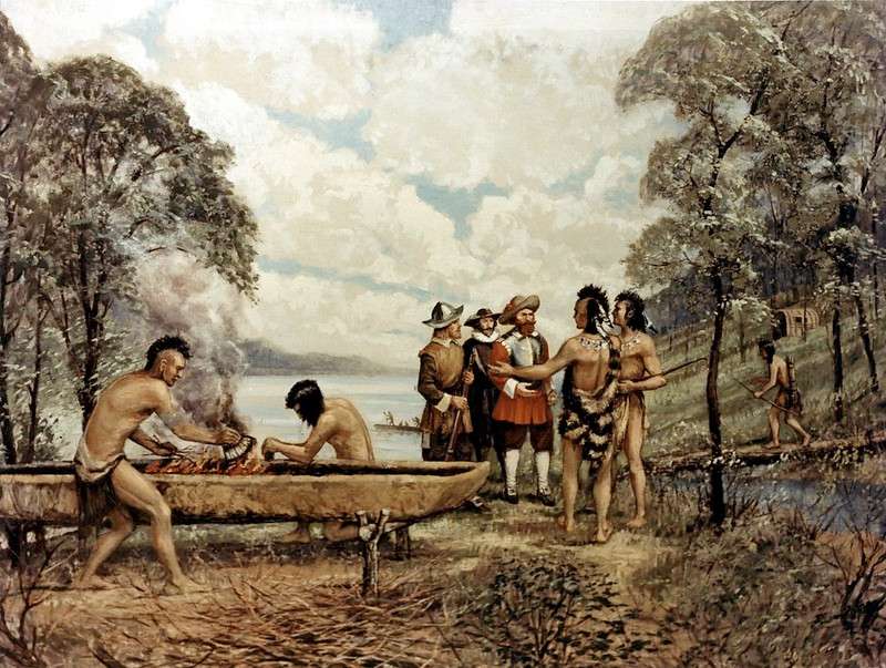
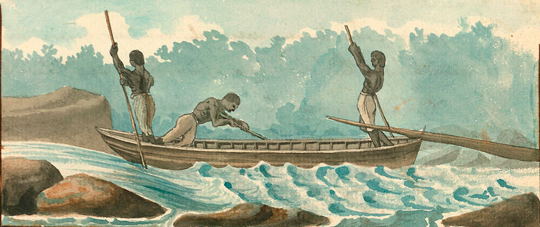
shipping by canoe was common long before European colonists arrived
Source: Federal Highway Administration, 1607 The Indian Canoe (painting by Carl Rakeman)
shipping by canoe was common long before European colonists arrived
Source: Federal Highway Administration, 1607 The Indian Canoe (painting by Carl Rakeman)
Based on the date of colonization of Australia, people have been using boats for transport for over 40,000 years. Paleo-Indians who moved south of the ice sheet near the end of the last Ice Age may have boated around the barrier. They would have followed the "kelp highway," feed on edible saltwater plants and marine mammals during the migration to ice-free land in modern Washington and Oregon.1
Native Americans in Virginia made canoes that were stable enough for crossing the Chesapeake Bay to the Eastern Shore. Human muscle propelled those canoes; Virginia's first inhabitants did not develop the technology of sailing ships powered by wind.
European explorations along the Atlantic Ocean coastline and into the interior of North America were incentivized by hopes of finding a "Northwest Passage" to China and the Spice Islands (now Indonesia). A direct route would eliminate the cost of dealing with Arab traders using the Silk Road, or with Portuguese/Spanish ships that controlled the trade by sailing around Africa.
King Henry VII authorized John Cabot, an Italian explorer, to seek a northern route to China. Cabot's ship Matthew reached what is now Canada on June 24, 1497. By landing at southern Labrador, the island of Newfoundland or Cape Breton Island, Cabot became the first European to visit North America since Leif Erikson and the Vikings. Cabot found no passage, but did discover the vast quantity of cod at the Grand Banks.
The Company of Merchant Adventurers to New Lands was founded in London in 1551, seeking to find a Northeast Passage. By selling shares to investors, the Company of Merchant Adventurers to New Lands became the first major chartered joint-stock company. Three ships sailed east from England, passing north of Scandinavia. They managed to reach the White Sea and opened up trade with Moscow, but could not sail further east through the ice.
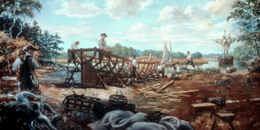
one of the first industries in the colony of Virginia was shipbuilding
Source: National Park Service, Boat Building at Jamestown (painting by Sidney E. King)
Richard Hakluyt published Voyages in Search of the North-West Passage in 1587. Searching continued for over 250 years, and in 1845 Sir John Franklin led an expedition into the Canadian Arctic in which everyone on the Erebus and the Terror died after the two ships were trapped by ice.
Not until the climate changed was it possible to sail through the Arctic Ocean. Canada claimed exclusive control of the waters off its northern coast in 2006, anticipating future use of that trade route. In 2018, a container ship sailed through Russian waters from Vladivostok to St. Petersburg, and by 2021 other ships were using the Northern Sea Route even in winter.2
Only in 1670 did a colonist, John Lederer, go far enough inland to see the western side of the Blue Ridge. In 1647, a visitor from England wrote about the colonists' dream of finding a route to the Pacific Ocean that was as short as the distance between the Atlantic Ocean and the Blue Ridge:3
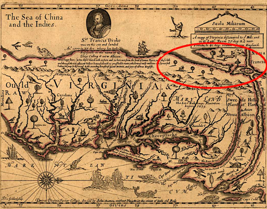
in the mid-1600's, the English still speculated that the Hudson River (far right of map) connected via a Northwest Passage to the Pacific Ocean
Source: Library of Congress, A mapp of Virginia discovered to ye hills, and in it's latt. from 35 deg. & 1/2 neer Florida to 41 deg. bounds of New England (by John Ferrar, published 1667)
In the very beginning of the settlement of Virginia by English colonists, ships sailing to Jamestown still followed the route via the Caribbean that had been pioneered by Christopher Columbus in 1492. The same traveler in 1647 reported the westbound trip from England required less than two months of sailing, and the eastbound trip required about three weeks:4
The trees in Virginia that were the raw material for canoes became the raw material in the 1600's for building sailing ships in Virginia. Shipyards were a common site along the coastline. Into the 1900's, there were still shipyards at Alexandria and Quantico on the Potomac River.
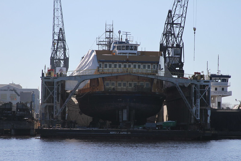
The shipbuilding industry continues today, most notably in the construction of aircraft carriers and submarines at Newport News. In addition, various shipyards on the Elizabeth River repair commercial as well as military ships, and the Norfolk Naval Shipyard (in Portsmouth) business from the US Navy is constant.
ship maintenance and repair is a major business along the Elizabeth River
Source: US Army Corps of Engineers, IMG_4644 and IMG_4624
After Jamestown was settled, ships from Europe sailed directly to the shoreline of Tidewater rivers. Ships sailed and rowed as far as possible upstream to access tobacco, lumber, and other cargo from farms. The ships docked at places known variously as wharves, piers, quays, and jetties. The names are not clearly distinct in what they describe, but normally a pier is built on piles driven into the riverbed and extends into the water while a wharf is built on piles and extends parallel to the shoreline. Jetties are built on fill and, like a pier, extend into the water. Quays are built on fill and, like wharves, run parallel to the shoreline.

shipping exhibit at the Morattico Waterfront Museum on the Rappahannock River (Lancaster County)
Littlepage's Wharf on the Pamunkey River was roughly 70 miles west of the Atlantic Ocean, but the river channel was deep. Ships from English ports could load and unload cargo there, and business was brisk enough for "Cumberland Town" to develop. After the Capitol in Williamsburg burned, Cumberland and Newcastle further upstream were considered as replacement sites. Unlike Williamsburg, ships could dock right at the edge of those towns.5

ships from English ports sailed directly to inland wharves such as Littlepage's Wharf in New Kent County
Source: ESRI, ArcGIS Online
As colonists moved westward beyond the Fall Line, they used wooden batteaux and gundalows to transport freight down Virginia's rivers to ports that were accessible to ships sailing across the Atlantic Ocean. Tobacco, corn and wheat could be packed into barrels and loaded on a batteau which could navigate shallow water and rapids in the Roanoke and James rivers. Lead "pigs" were transported down the Shenandoah River to the Chesapeake and Ohio Canal at Harpers Ferry and, later, to the Manassas Gap Railroad at Front Royal.
The lumber in boats could be sold at the end of a trip, and the boatmen returned upstream via the local road network. Many boatmen were enslaved or free people of color. Travel on the rivers may have been dangerous and exhausting, but the trips offered them a measure of personal control over their lives.6
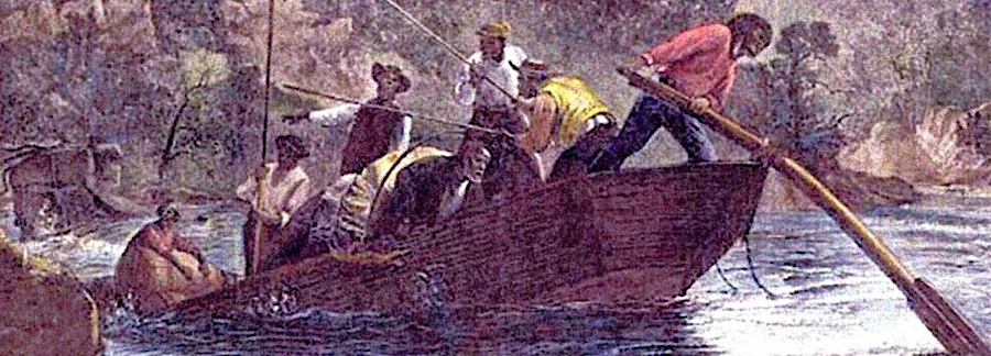
a batteau could navigate through shallow water and rapids
Source: Library of Virginia, Steering a Bateau, Watercolor (by Benjamin Henry Latrobe, 1798) and Harper's Weekly (February 21, 1874)
There was no Northwest Passage through Virginia, and the Fall Line blocked shipping from getting west of the Coastal Plain. The solution was to build canals, which made it easier to ship bulky and heavy freight upstream and downstream. Canals removed the risks of rapids, and could be used even during times of low water. Further north, canals eventially made it possible for oceangoing ships to use the St. Lawrence River and Great Lakes to reach the Port of Duluth-Superior in Minnesota, 2,342 miles inland from the Atlantic Ocean.7
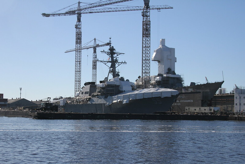
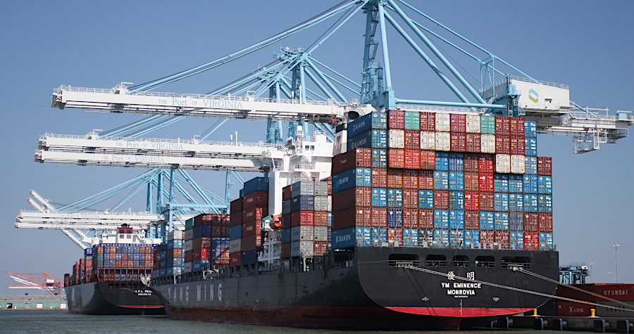
Since 1607, Virginia has always been engaged in international trade using ships constructed in other places. Modern tankers and container ships export products such as coal, soybeans, and tobacco. Imports of containerized cargo and bulk materials arrive at Hampton Roads ports, primarily.
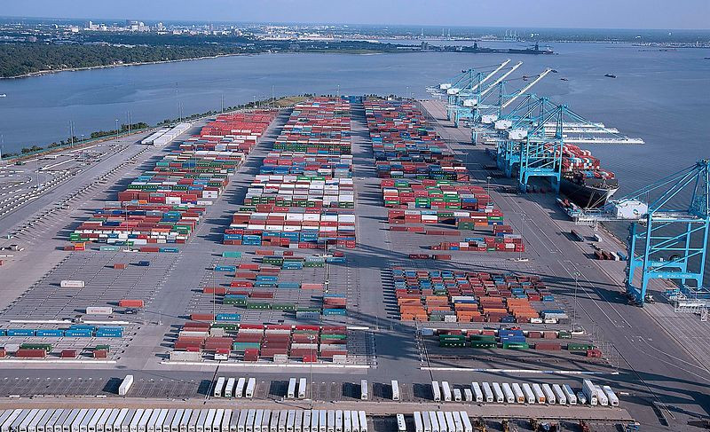
containerized shipping revolutionized Virginia's port operations starting in the 1960's
Source: City of Norfolk, Norfolk From the Air
The Commonwealth of Virginia has consolidated control of the terminals that handle containerized cargo. The Virginia Port Authority owns or leases all the facilities where consumer goods from China and Europe are unloaded, though private companies still control individual shipping terminals for coal, petroleum, and grain. Consolidation has increased efficiency, allowing the state to schedule loading/unloading where space will be available.
The COVID-19 pandemic triggered a surge in demand for goods manufactured in Asia. That led to a supply chain interruption, and in 2020-2021 ships had to wait long times at West Coast ports to unload. More ships began to sail from Asia to East Coast ports. Business expanded initially at Savannah and New York, the first East Coast ports where most ships stopped. Virginia ports in the middle of the Atlantic Coast also benefitted from increased traffic, and the pandemic triggered structural changes in shipping patterns.
By 2023, the market share of West Coast ports for processing imports had dropped from roughly 50% to 42%. Imports of manufactured goods shifted away from China to Southeast Asia and Latin America. Gulf Coast ports captured most of the shifting traffic, but East Coast ports grew by 3%.8
A key reason for the smooth operations in Virginia during the COVID-19 pandemic was that it was the only place in North America in 2021 where the port owned the chassis pool. The port, a state agency, owns the chassis used to move containers from ships to rail cars or trucks. Having the state allocate all the chassis helps minimize congestion. In the "bad old days" when shippers owned the chassis, it was common for one company to have a shortage while another company's surplus supply sat idle.
A National Public Radio story explored the history behind that unique situation:9
In 2020, the largest container ship ever to visit the East Coast up to that time stopped at the Virginia International Gateway (VIG) terminal. It could carry 15,072 TEUs (twenty-foot equivalent units at one time, but such vessels top at multiple ports to load/unload just a portion of their cargo. At the Portsmouth terminal, port workers moved 3,300 containers from the ship as imported goods, or onto it for export.10
massive container ships stop at the three terminals of the Port of Virginia in Hampton Roads
Source: I-564 Intermodal Connector Project, Project Fact Sheet
In 2022, the U.S. Customs and Border Protection agency in the Department of Homeland Security shifted oversight of Virginia ports and airports from its Atlanta office to Baltimore. That consolidated responsibility for customs and security for the Chesapeake Bay in one office. The Area Port of Norfolk-Newport News remained unchanged, except it reported to a different office after the shift.11
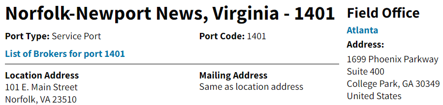
the U.S. Customs and Border Protection agency office overseeing Virginia ports was in Atlanta until a shift in 2022 to Baltimore
Source: U.S. Customs and Border Protection, Norfolk-Newport News, Virginia - 1401
colonial waterfronts were industrial areas of a town, with wharves and warehouses
Source: National Park Service, Colonial Yorktown Waterfront (painting by Sidney E. King)
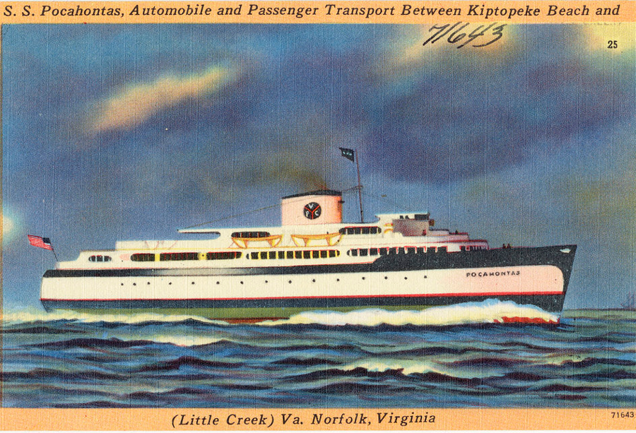
a pre-World War II postcard shows a ferry that ran between the Eastern Shore and Princess Anne County (now the City of Virginia Beach) until the Chesapeake Bay Bridge-Tunnel opened in 1964
Source: Boston Public Library, S. S. Pocahontas, automobile and passenger transport between Kiptopeke Beach and (Little Creek) Va., Norfolk, Virginia
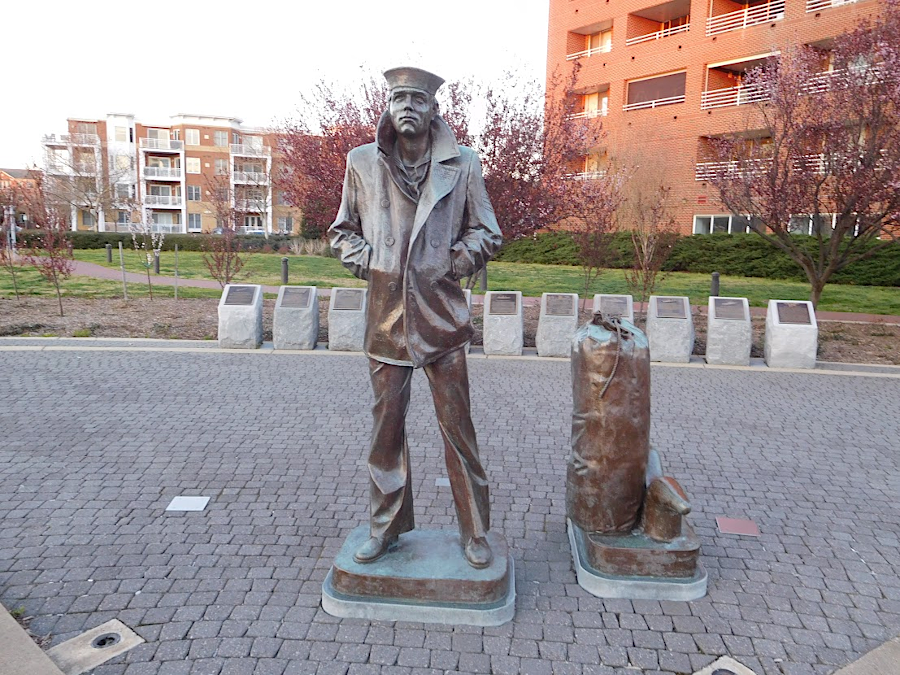
Norfolk honors its nautical history with a statue of a sailor at Freemason Harbor
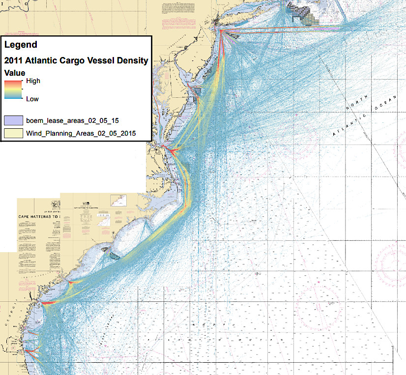
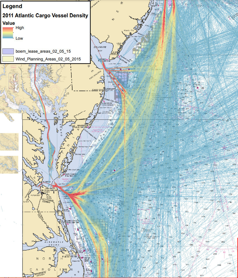
in 2016, the US Coast Guard assessed where potential offshore wind facilities would create the greatest risk to shipping
Source: US Coast Guard, Atlantic Coast Port Access Route Study (Appendix III, p.2, p.19)