Before we drink it or flush it... our water comes from somewhere. Those water molecules have already been to other places before. The water in wilderness creeks is not pristine or even safe to drink without treatment. Even if you catch a snowflake on your tongue, remember that "pure as driven snow" means "pure as recycled water."
We also recycling material in this class from previous weeks. Geography is a cumulative learning experience, where everything is connected to everything else. Feel free to review:
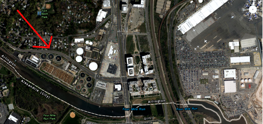
the Arlington wastewater treatment plant discharges into Four Mile Run - and no jurisdiction withdraws drinking water from the Potomac River downstream of that point
Source: ESRI, ArcGIS Online
The different campuses of George Mason University are supplied by a Community Water System (CWS). The major Community Water Systems in Northern Virginia add flouride to the drinking water, to adjust the fluoride concentration upward to the optimum level for the prevention of dental caries (cavities).
Some small systems in Loudoun County, such as the Town of Middleburg and the Raspberry Falls Subdivision, do not add flouride.
Those of us who live on individual well-and-septic systems in rural areas do not even get chlorine added to our drinking water.
Water without chlorine is better for the goldfish. In urban areas, owners of goldfish get water from the faucet and then leave it in a separate bowl overnight. That allows enough time for the added chlorine to evaporate away.
rural residents need to keep manure and other contaminants away from their drinking water well. Virginia Department of Health regulations require drinking water wells to be at least 50 feet away from known contaminant sources, such as septic tanks and their leach fields.
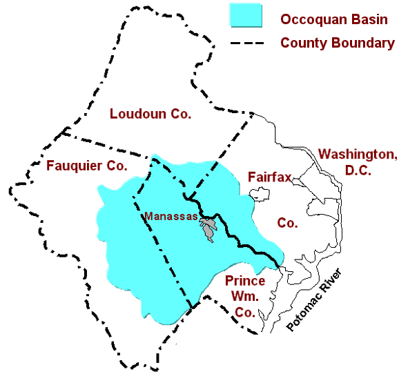
Occoquan Reservoir, the source of drinking water for about half of Fairfax County, receives treated sewage from Fauquier, Prince William, and Fairfax counties plus the cities of Manassas and Manassas Park
Source: Northern Virginia Regional Commission
The Occoquan Reservoir was built in 1950's by a private for-profit corporation to supply drinking water to Alexandria, replacing Lake Barcroft as the city's primary source.
The County of Fairfax acquired the private reservoir through condemnation. The private utility did not want to sell its profit-making operation, which had great potential for future growth. However, Fairfax County wanted to control its water rates in order to attract business and keep voters happy with low-cost, high-quality water. (The seizure of Alexandria's water supply may also have been a hardball negotiating tactic, used to block plans by the city to annex more land from Fairfax County.)
The Occoquan Reservoir is the primary source of drinking water for about half of Fairfax Water customers. The City of Alexandria and eastern Prince William County (Dale City) are still serviced by private, for-profit utility companies that buy water at wholesale rates from Fairfax Water, and resell to customers at retail cost.
As Fairfax County developed in 1960's, the Occoquan Reservoir was heavily polluted by human sewage. Small "package" sewage treatment plants built for new subdivisions killed bacteria in human waste from all the new houses, but those facilities did not remove nutrients (especially nitrogen and phosphorous) from wastewater. Fertilizers on suburban yards also washed downstream into the reservoir.
By the early 1970's, Occoquan Reservoir was organic soup. Blue-green algae (cyanobacteria) covered the surface, and the stench that made clear something had to be done.
Alternatives included 1) block construction of new housing units in the Occoquan watershed, 2) pipe all wastewater to sewage plants outside of the watershed, or 3) upgrade the sewage treatment processing plants in the watershed.
The ultimate solution was to replace the existing sewage treatment systems. The regional Upper Occoquan Sewage Authority (UOSA) built a state-of-the-art facilty to replace all of the old sewage plants (NOTE: the Occoquan Forest plant on Davis Ford Road in Prince William will be the last to close, soon...).
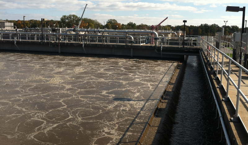
Since 1978, the UOSA plant on Bull Run near Centreville has processed sewage so completely, you could drink the effluent that emerges at the discharge site. Yes, the sewage plant prodict is drinking water quality.
Whatever is shoved down garbage disposals, discharged from showers, and flushed down toilets in Centreville and Manassas goes through UOSA in Centrevile, then 12 miles later becomes the drinking water for half of Fairfax Water customers (as well as City of Alexandria and eastern Prince William).
Many people do drink the UOSA sewage discharge - at times, including people using water fountains on the Fairfax campus of GMU.
No, the Farfax Campus does not have a direct toilet-to-tap connection. The UOSA effluent flows 12 miles down Bull Run to the Occoquan Reservoir first, before reaching the intake for Fairfax Water's Griffith Water Treatment Plant at Lorton.
Wastewater discharged from UOSA facility is cleaner than water in Bull Run itself. It would be cost-effective to pipe water directly from sewage plant to Fairfax Water drinking water treatment plant at Occoquan. However, customers might object to a direct toilet-to-tap system. That is why clean water is dumped into Bull Run, that clean water gets dirty as it moves downstream, then the water from the Occoquan Reservoir is cleaned again at the Griffith Water Treatement Plant in Lorton. (Hey, how does that sewage taste?)
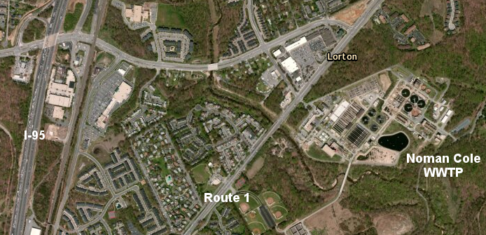
in contrast to the Upper Occoquan Sewage Authority facility, treated waste discharged from the Noman Cole Wastewater Treatment Plant (WWTP) in Lorton flows into Pohick Creek - and no drinking water facility pumps brackish water from the Potomac River downstream of Lorton
Source: ESRI, ArcGIS Online
In Hampton Roads, Portsmouth is mimicking the Falls Church approach.
Portsmouth makes a 20% profit from its city-owned water system. The city can not tax Federal and state land, such as the Norfolk Navy Yard - but the high cost to provide water to tax-free facilities enables the city to generate additional revenue, and keep property taxes substantially lower. Local voters pay higher-than-necessary water fees, but appreciate the lower property taxes. State and Federal agencies just get stuck with the higher utility fees, and get no benefit from lower property taxes.
There is an old ditty about how voters suggest who should pay higher taxes: "Don't tax him, don't tax me; tax that man behind the tree." Think state/Federal agencies are behind the tree, and Portsmouth is imposing a backdoor tax via high water fees?
In 1975, the Federal government sued Newport News, claiming it was charging excessive fees for water and transferring profits to the general fund so property taxes would be lower. A judge ruled that the city, like a private utility company, was entitled to make a profit.1
Think that Portsmouth may have to defend in court if its 20% profit is "reasonable"?
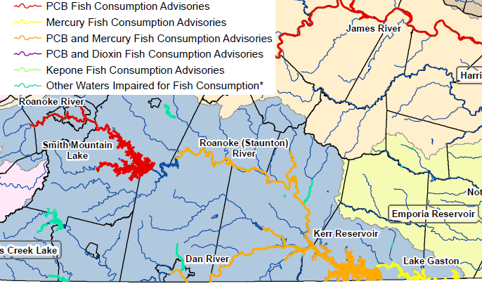
Virginia Department of Health (VDH) officials determine whether the water and fish are safe for drinking/eating. The Department of Environmental Quality (DEQ) is a a separate state agency that assesses water quality and prepares TMDL plans.
The water flowing off the eastern side of GMU's Fairfax Campus drains into Pohick Creek. If you were a good angler and caught a smallmouth bass at the mouth of Pohick Creek each week, would it be safe to consume that fish four times/month?
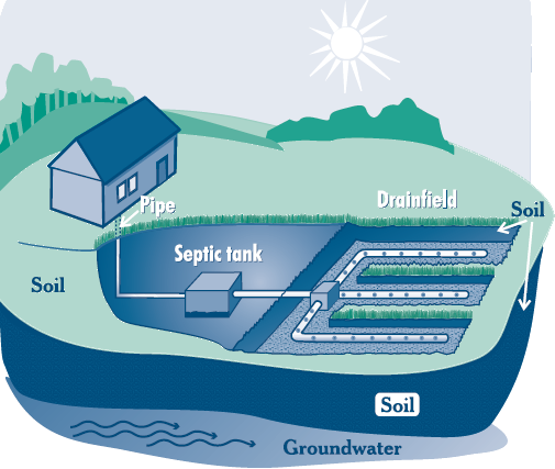
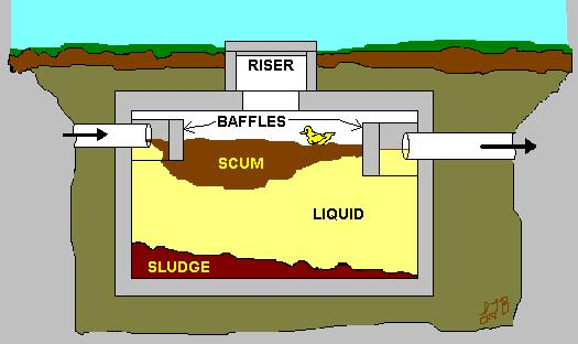
septic systems are underground wastewater treatment facilities that rely upon bacteria to purify wastewater
Sources: Environmental Protection Agency (EPA), A Homeowners Guide to Septic Systems and Carroll County (Maryland) Health Department, Septic System Manual
Drinking water was brought to houses first. Until pipes brought an excess of water into the house, there was not enough water inside to flush away any sewage. (Hauling water by hand is heavy - a pint weighs a pound.)
*After* urban areas developed drinking water systems, people installed indoor toilets, bathtubs, kitchen sink disposals. A second set of pipes was needed to carry wastewater away once there was plenty of water inside houses.
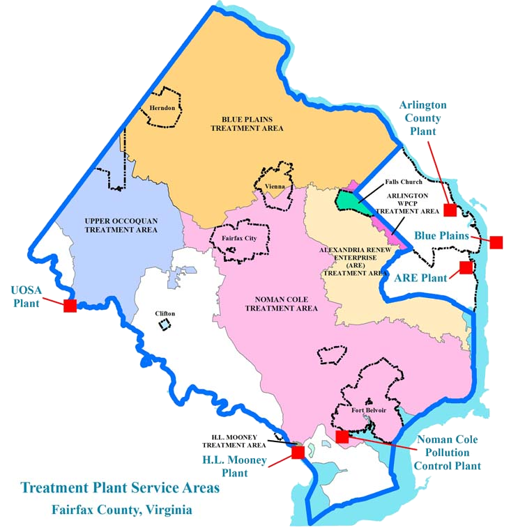
Every bathroom on a GMU campuses is linked by underground pipes to a wastewater treatment plant. Each campus is connected to a different wastewater treatment plant. If you flush at the campuses in Arlington or Prince William, the waste does not go to the Noman Cole Wastewater Treatment Plant in Lorton.
Noman Cole (there is no "r" in his first name) was an engineer, political activist, and head of the Virginia Water Control Board. His legacy to reduce water pollution is reflected in the name of Fairfax County's sewage treatment plant.
gravity moves sewage through most wastewater pipes (in contrast to the pressurized pipes used for distribution of drinking water), so topography is a key factor determining location of wastewater treatment plans and which areas send sewage to different facilities
Source: Fairfax County, Wastewater Treatment
Recycling is easy for water bottles and newspapers - but recycling organic waste is harder.
Some homeowner associations (HOA's) in Virginia ban birdfeeders and prohibit composting of kitchen waste outside, because the organic material attracts rats.
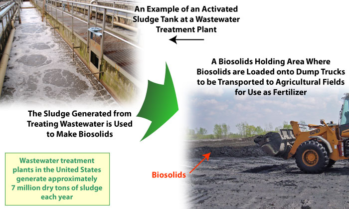
Arlington County used to incinerate the sludge remaining in the bottom of its wastewater treatment plant on Four Mile Run, next to National Airport.
The county now disposes its sludge as a "biosolid," after politically-influential neighbors complained that the perception of vapors coming frm the incineration process reduced land values of houses on Arlington Ridge and near the plant.
Biosolids can be shipped to landfills, but paying for space at a landfill is expensive.
If processed to Class A standards, biosolids can be sold at Home Depot and Lowes as a soil conditioner for landscaping suburban gardens, helping to reduce costs.
If processed just to minimum standards, biosolids can be trasported to farms and forests and used as fertilizer, just like livestock manure.
Farmers and forest managers appreciate the value of the fertilizer, but finding places to apply it is a challenge.
Neighbors of the land application sites rarely view spreading human biosolids on nearby fields as equivalent to spreading livestock manure, and create controversy for local governments that issue permits.
Recycling human waste on farms and forestland, even after the waste has been processed into a "biosolid," can affect land values of adjacent properties.
All waste ends up on land, in water, or in the atmosphere. Sludge extracted from human sewage can be incinerated, landfilled... or applied to pasture and forests as a fertilizer. After you flush... it's gotta go somewhere. Do you prefer the Fairfax County process at Lorton, where the biosolids remaining after wastewater treatment are incinerated by natural gas - or the recycling of "poo" on farm fields, in forests, and at mine reclamation sites?
Northern Virginia has few manufacturing facilities with industrial waste going into the sewer pipes, so biosolids should have relatively low levels of heavy metals and toxic chemicals - but may include organic chemicals from personal care products and drugs used by humans (including birth control pills)
Source: US Geological Survey (USGS), Household Chemicals and Drugs Found in Biosolids from Wastewater Treatment Plants
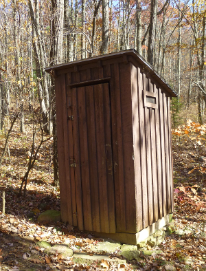
Today, pipes carry waste from the bathrooms in the visitor center at Mount Vernon to the Noman Cole Wastewater Treatment Plant at Lorton, on Pohick Creek. When George Washington lived there, there were no pipes and no sewage treatment process. Everyone used the "necessaries" outside, known today as outhouses. Slaves cleaned out the waste, so there would always be room for more deposits from Washingtn's family and his guests.
In urban areas, with relatively high density of houses, sewers carry waste away from the house to a centralized wastewater treatment plant. It is not cost-effective to extend sewer lines to every house in rural areas, so those houses still rely upon on-site wastewater disposal. At one time, "on-site wastewater disposal" consisted of an outhouse, with a half-moon carved in the door. Aerobic bacteria decomposed the waste deposited in the outhouse, creating a stink that anyone who has used an outhouse will remember.
Today, rural residents flush indoor toilets, and the waste goes to a septic tank. Cigarette butts and other items that do not biodegrade will accumulate in the bottom of the tank. In a worst-case scenario, solids in the tanks will rise so high that they flow into the pipes that carry the liquids to the leach field. Once the leach field pipes or the soil particles near the pipes get clogged, the liquid waste will rise to the surface and the yard will stink.
A failed leach field is a health hazard. Homeowners with a failed septic system must replace it. An Alternative On-site Septic System (AOSS) can cost over $30,000 to install, plus $500-$1,000 annually to maintain.
Some solids do not percolate ("perc") fast enough for a leach field to work. To get a building permit for a new house on a rural lot where a septic system will be used, county sanitarians must first certify that the soils perc. A perc test involves digging a hole, filling it with water, and seeing how fast the hole drains. In sandy soils on the Coastal Plain, water can drain away quickly - but in the Piedmont, clay particles in the soil can block the flow of fluids underground, and the water just sits in the perc test hole. Parcels without a suitable site for a septic system are rarely undeveloped, due to the cost of an Alternative On-site Septic System... but if developers can get a sewer extended to such an area, then low-value farmland can be converted into high-value homesites.
In theory, local officials can zone rural areas for low-density development. Concentrating public facilities (sewers, schools, roads...) in selected areas zoned for development can result in lower water/sewer rates and lower property taxes. In practice, maintaining an urban growth boundary is politically challenging. The political pressure to extend sewers can be intense in western Loudound and western Prince William counties, because the economic value of a non-perc site can be transformed by a sewer.
what three cities in Virginia have Combined Sewer Overflow (CSO) facilities? How are they preventing raw human waste from being washed into streams?
UOSA plant blows air into nutrient removal tanks to create aerobic and anaerobic conditions, so different bacteria convert nitrogen in wastewater into nitrogen molecules that are released into the atmosphere in a form that is harmless (N2)
The benefits of sealing a landfill inside a watertight cell are being re-examined. Landfills generate methane for only 20 years or so. Afterwards, they often become an inert, hunk of wasted land unless someone has a creative alternative (see next item...). One future option: crack open the clay cap, invide water to seep into the landfill and perpetuate decomposition, let the waste pile shrink over time - then mine the remaining metals from the residue and start re-filling the landfill again.
For-profit waste management companies refer to waste-to-energy facilities; it is rare now to hear even county officials call the Covanta facility an "incinerator."
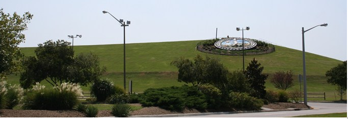
Mount Trashmore in Virginia Beach, a capped municipal landfill, provides valued parkland
Source: Google Maps
Mount Trashmore may be the highest elevation in Virginia Beach
Source: Virginia Tourism Corporation, Mount Trashmore Park
Bringing New York City municipal solid waste to Charles City County, Virginia
As Garbage Piles Up, So Do Worries (Washington Post article, November 12, 1998 - read the continuation for "Inside Loads, Illegal Waste" too)
In 1992, state regulations required municipal solid waste landfills to install clay/plastic lining to keep fluids out of the groundwater. Regulations also mandated clay caps to seal the surface from rainwater intrusion that would become contaminated leachate leaking out of the landfill, and methane capture systems to prevent gas from decomposing organics from cracking the clay caps.
Some larger jurisdictions, such as Alexandria, Arlington, and Fairfax County, built incinerators to reduce the volume of their municipal solid waste by 90% and dispose of inert ash. Others, such as Prince William County, developed new landfills that could comply with environmental standards. Still, almost 250 old landfills shut down because of the additional cost. According to the Virginia Waste Industries Association, "the number of landfills operating in Virginia has declined, from about 328 in 1987 to about 74 today."2
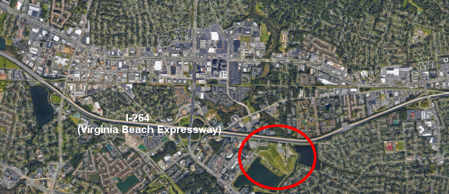
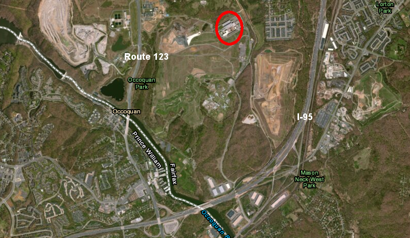
the waste-to-energy facility that incinerates Fairfax County waste is located between Route 123 and I-95,
east of the Griffith Water Treatment Plant, Vulcan Quarry, and the Occoquan Reservoir
Source: ESRI, ArcGIS Online
Private companies saw a business opportunity, and built large "mega-landfills." These were located in rural counties where land costs were low, and near urban centers to minimize the cost for hauling trash. To reduce construction costs, most mega-landfills were located in the soft sediments of the Coastal Plain. King George County has one just east of the Fall Line; others are in Sussex, Charles City, King and Queen, and Gloucester counties. Two mega-landfills were built in the Piedmont physiographic province: Brunswick and Amelia County.
As landfill capacity expanded, the growth of trash changed. New packaging, recycling, and composting affected how much municipal solid waste was being hauled to the mega-version of the "dump." Landfill operators responded like smart business owners: they went looking for new customers. Building a landfill near New York City is expensive, because land is so valuable. Even after accounting for the cost to ship trash via truck, train, or barge, Virginia landfill operators could charge a lower "tipping fee" and out-compete landfills in New Jersey, Pennsylvania, or New York.
Virginia ended up being the second-largest importer of out-of-state trash. The majority of waste in the mega-landfills is imported rather than generated in Virginia.3
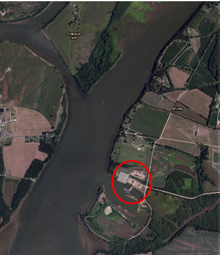
In 1998, after New York trash started to arrive on barges for disposal at the mega-landfill in historic-but-poor Charles City County, garbage juices leaked into the James River. (Why ship by barge? 6,000 tons of trash per barge is equivalent to about 300 tractor trailers. It is cheaper to move trash by water, but only ne Virginia landfill has a dock for unloading...)
In response to public uproar, Virginia tried to block import of municipal solid waste from other states. However, waste is interstate commerce, just like computer chips and Fritos. The US Constitution ensures an individual state can not block interstate commerce, so today Virginia is a trash can for New York.
Out-of-state municipal solid waste is barged to "Port Tobacco," a former sand and gravel operation just downstream from Shirley Plantation in Charles City County. The historic site on the James River claims "Shirley Plantation is the oldest family-owned business in North America, dating to Edward Hill I establishing a farm in 1638. Construction of the present mansion began about 1723..." and the business needed income, so it approved the garbage operation.4
Source: ESRI, ArcGIS Online
If wastewater flows out of a pipe into a perennial stream (i.e., a streams that has water flowing in a natural or man-made channel year-round, except during periods of drought), then the wastewater is regulated as a "point source" of pollution.
If water flows across a farm field or forest and drains into a stream without going into a channel, then the nutrients, chemicals, and other contamination in that water is considered to come from a "non-point" source.
The Clean Water Act focuses on managing pollution from point sources. The Virginia Department of Environmental Quality (DEQ) issuses Virginia Pollution Discharge Elimination System (VPDES) permits to regulate the quality of wastewater coming from point sources.
Urban stormwater is artificially channelled into ditches, so the water flows into nearby streams rather than into basements of houses. The local town/city/county governments must get Municipal Separate Storm Sewer System (MS4) permits from DEQ.
In 2014, new state stormwater regulations went into effect. New developments in Virginia must capture more stormwater and reduce the fast-flowing discharges into streams, which should reduce erosion in stream channels and help save the Chesapeake Bay.
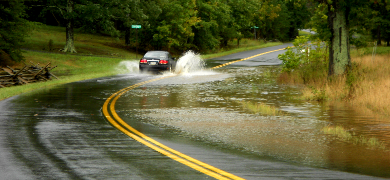
floodwaters on street, washing pollution (oil, worn tire particles, metal filings from brake pads) into local stream
How Much Stormwater Does One Inch of Rain Produce?
When it rains, about 5% of the rain water runs off wooded areas and about 95% of the rain water runs off a parking lot. During a one inch rainstorm...
1,360 gallons of water runs off a one-acre wooded area
25,800 gallons of water runs off a one-acre parking lot
Videos:
- I Can't Believe It's Not Poo on GMU-TV
- The Dump" on GMU-TV (municipal landfills no longer resemble the classic "dumps" with rats and smouldering debris...)
Map Exercise:
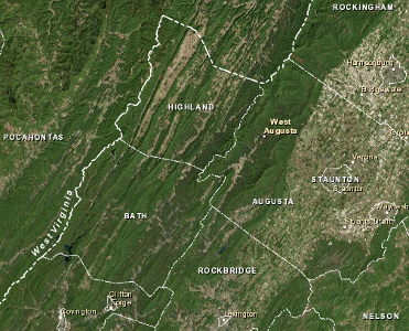
West Strait Creek in Highland County is on the list of "impaired" waterways in Virginia as defined in Section 303(d) of the Clean Water Act, so the Town of Monterey had to upgrade its wastewater treatment plant.
In the 1990's, the town used constructed wetlands for secondary treatment of its wastewater. After primary treatment (screening and settling of solids, followed by anaerobic bacteria digesting organic material), the effluent was directed into six artifical wetlands. In theory, bacteria on the roots of plants in the wetland cells were going to "eat" the remaining nutrients, and releases into West Strait Creek would meet water quality standards.
However, the partially-treated wastewater was not cleaned sufficiently by biological activity in the wetlands. West Strait Creek had excessive amounts of nitrogen (in the form of ammonia) and inadequate oxygen. Bacteria in the stream fed on the nutrient-rich wastewater and, in the process, reduced the oxygen levels in the water. On November 4, 2008, voters approved a bond issue to build an expensive new treatment plant.
If you go to the next Highland Maple Festival in March, 2017, whatever you flush will go through the wastewater treatment plant and end up in West Strait Creek. Where will it go from there? Get out the Delorme Atlas and Gazetteer, and follow the creek downstream. Who will end up drinking that water?
Monterey is the county seat of Highland County
Source: ESRI, ArcGIS Online
Site Visit:
What is the source of your water at your site? Where does it go, when you are done with it?
- what is your water source? You can search for it by county on EPA's site at Safe Drinking Water Search for the State of Virginia)
- what is your "source water area" for that water supply, the region around your water intake - and is the quality of your drinking water at risk from new industrial facilities or residential development over the next 20 years? (If you use a municipal or community water system, look at Local Drinking Water Information for a source water report.)
- if your water comes from a well at the site, how deep is the well? Think the heavy rains that fell in Superstorm Sandy have already seeped down to that aquifer and that rainwater is already being recycled through your well? Where is the "source water area" for your well, where the water seeps into the ground... or is everything nearby already paved over, and you may be mining water that's been deep underground for perhaps 1,000 years and will never be replenished?
- assuming you have a house somewhere on your site, calculate how often the different toilets are flushed. Multiply by the volume of water used by your toilet for each flush (old ones use up to five gallons/flush, new ones use around one gallon/flush).
- calculate the water leaving your shower every day. Assume you have a five gallon/minute showerhead, unless you know you have a low-flow showerhead installed. If the average shower in your house is 5 minutes, and there are 4 showers a day, you can calculate the volume of the wastewater going into the drain (5 gallons/minute x 15 minutes x 4 showers/day = 300 gallons/day).
- where does sewage from your site go? If you're in an urban area, what wastewater treatment plant is "downhill" from you? How many miles will your sewage flow before it gets treated?
- If you have a septic tank... what natural stream will ultimately receive the effluent that moves by gravity out of your leachfield?
- After your waste gets to the treatment plant or nearest stream, what waterways does it flow down on its path to the ocean? Looking at the DeLorme Atlas and Gazetteer, and Safe Drinking Water Search for the State of Virginia... how many other communities pump your treated sewage into their drinking water treatment plant?
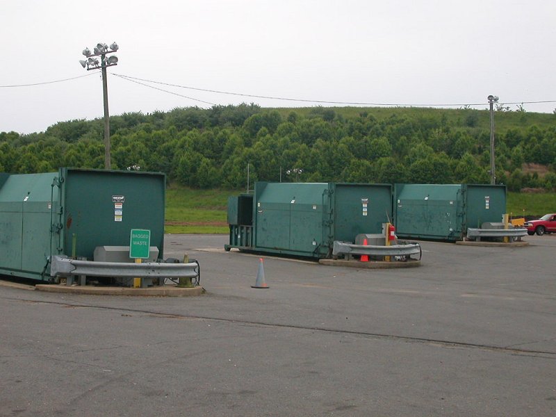
waste collection at I-66 transfer station in Fairfax County (with closed landfill in background)