Lots of facts and data here; this is, after all, a 300-level college class. Still, don't try to memorize dates. Quizzes are open book, and in real life you can always ask Siri or do a Google search for factoids. Instead, pay attention to the pattern - the Spanish, French, and English tried to settle at different places and at different times, but for some common reasons (think "private wealth" and "international power").
The Spanish lacked the resources to occupy the Caribbean, Mexico, and South America where there was god, silver, and slaves; resource-poor North America was thus a marginal objective. North America lacked gold and the Native Americans there made poor slaves, so the Spanish did not invest in planting colonies north along the Atlantic Ocean coastline.
The French and Spanish fought wars on the European continent and contested for control of North America, while the English sat on the sidelines for the first 80 years of the 16th Century.
The French initially followed an "in your face" approach that challenged the Spanish directly, planting settlements 350 miles closer to the Caribbean than the English did at Jamestown. The English would be more cautious when they tried to plant colonies in North America, to minimize the chance of Spanish retaliation.
Since Henry VIII married the Spanish princess Catherine of Aragon in 1509, the English had been allies with the Spanish and fighting the French together in Europe. That marriage did not turn out well - but at least he only divorced her in 1533. He had an executioner cut off the head of the next wife, Anne Boleyn, after just three years of marriage.
Henry and Catherine's daughter, Mary, renewed the political connections between England and Spain when she married Philip, a Spanish prince. After Henry VIII died she became England's first woman ruler.
After Queen Mary died in 1558, the next queen was her half-sister Elizabeth. She was was a Protestant, and not an ally of Spain. In the day when marriages between rulers created/broke alliances, she stayed unmarried and - in the culture of that day - was supposed to stay a virgin. England ended up fighting Spain, most notably defeating the Spanish Armada in 1588.
Bottom Line: The timing of English colonization in North America, starting in the 1580's, was based on international and religious rivalries in Europe. The first efforts to settle on the Atlantic Coast were delayed until Protestants took full control of England under Queen Elizabeth and the English/Spanish alliance fell apart. Sir Walter Ralegh sought to ingratiate himself with the queen by naming his colony "Virginia," honoring her unmarried status.
The Spanish had 5 reasons to occupy Virginia... but made only one feeble attempt.
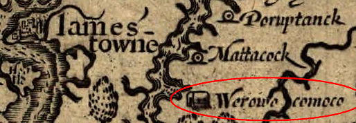
Understand why the Jesuits walked from the James River to the York River to create their new settlement, and why no one in 1570-71 would have called thouse rivers after King James or the Duke of York in England.
After the English settled Virginia in 1607, the Spanish chose diplomacy over war with England, in their efforts to control territory in the Western Hemisphere.
Note that the French tried to settle south of the Chesapeake Bay, before their focus on Canada starting in the early 1600's. (Gotta feel sorry for a colony in which everything but the wine froze solid...)
The French sought to settle Canada, the Gulf Coast, and the Mississippi River watershed - but did they plan to fill North America with immigrants sailing from France? Did they invest heavily in sending people to North America to build towns, or was there a different strategy?
How did French colonization affect Virginia's Governor Spotswood plans for settling lands west of the Blue Ridge?
Just what was the English legal doctrine for claiming the right to occupy Virginia, displacing the Native Americans while blocking the Spanish, French, and Dutch from occupying the territory?
"Why do you think the English built a fort? It was not to keep the Indians out, but to keep the Spaniards out." Keith Smith, Nansemond Tribal Member (March 4, 2004)1
Were the Jamestown colonists the first English to see Virginia?
Of course, be clear on why Walter Ralegh named his colony "Virginia."
The leader of the 1587 attempt returned to Virginia, leaving his new grand-daughter Virginia Dare behind. Why did John White leave the Roanoke settlement, and why didn't he return to Virginia in 1588 as planned?
The colonists on the Mayflower (those latecomers who arrived in 1620...) spent a month exploring Cape Cod before deciding to settle at Plymouth. That location was right on the shoreline, not hidden upstream. Plymouth was also significantly further north from the Spanish bases in the Caribbean and La Florida.
The first Jamestown buildings had wooden frames and walls of wattle-and-daub (sticks covered with mud). They are often called "mud-and-stud" by archeologists excavating Jamestown now. Roofs were thatch, made from cattails or reeds from the local swamp.
The Jamestown structures were not have bark-covered huts like the houses in nearby Algonquian villages, and there were no log cabins with cedar shake roofs. Log cabins were introduced later by Scandinavian settlers, coming to Delaware in the 1640's.
Fires burned all winter for warmth and cooking, so the walls and roofs stayed dry despite fog and rain. With fires burning constantly in nearly every structure, it is not surprising that the fort burned by accident in January, 1608.
Living at Jamestown was tough. Dying at Jamestown was easy. Half of the 104 colonists who arrived at Jamestown in May, 1607 were dead by the end of that year.
Bodies were buried within the walls of the fort, to disguise the weekness of the colony from the Native Americans.
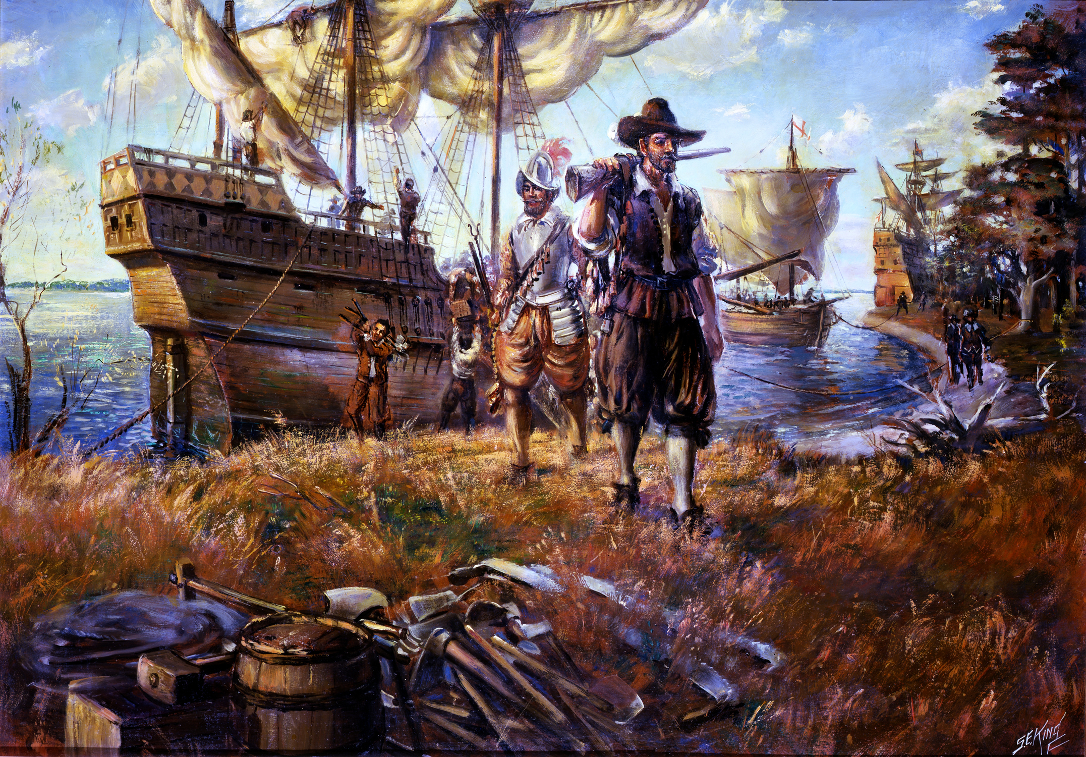
three English ships arrive at Jamestown Island
Source: National Park Service, Sidney King Paintings
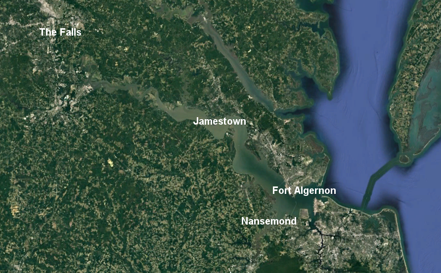
The Third Supply was supposed to bring new energy and new resources to the colony, but the key leaders were stranded for the winter of 1609-10 on an uninhabited island
Francis West would not acknowledge John Smith's leadership role as president of the colony, so he took a group upstream to the Fall Line.
George Percy and John Martin took a second group downstream to the Nansemond River.
Captain Davis commanded an outpost with some settlers at Fort Algernon (modern-day City of Hampton), to provide a warning if Spanish warships arrived in the Chesapeake Bay.
Dispersal of the colonists in three places other than Jamestown gave them a greater chance at accessing food supplies in different locations, but after Smith was wounded the groups at the Fall Line and Nansemond returned to the fort at Jamestown.
In the "what coulda been" speculations: if John Smith had stayed in Jamestown... perhaps he would have split up the settlements, and many of the colonists would have survived the Starving Time.
Jamestown was at the end of a supply pipeline, and the under-capitalized Virginia Company failed to send enough supplies.
In 1609, seven ships of the original Third Supply convoy arrived in late summer, with 300 hundred hungry colonists and few supplies for the winter
The Virginia Company planning was fatally incompetent. Existing colonists were not directed in the Spring to plant extra crops to feed the new colonists who would arrive in late Summer.
The seven ship captains who made it to Virginia in 1609 lingered so long in Virginia that many of the supplies which survived the hurricane were consumed by sailors, rather than stockpiled for the winter.
George Percy failed to disperse the colonists, and those who stayed in the fort at Jamestown starved while the group at Fort Algernon had plenty of food
the colonists at Jamestown failed to use common sense to survive starvation, suggesting they were mentally depressed and perhaps physically affected from drinking "brackish" water from the James River that had a higher-than-average level of salt during the drought
Locating Jamestown, so it was easily accessible by ship, did not guarantee enough ships would bring supplies to that North American port. In Virginia today, poverty and physical threats are not unknown, but actual starvation is very unusual. If you ever watched the television show Star Trek, notice how rarely the scriptwriters put the characters into a position of real scarcity. Oh, they need dilithium crystals at times, but do you think the modern TV audience could be retained if a science fiction show presented the intergalactic equivalent of the slow death faced by the Jamestown colonists in 1609-10?
many of the colonists in the seven Third Supply ships that managed to arrive in August, 1609
ended up at The Falls and Nansemond, in part because the newly-arrived leaders were unwilling to allow John Smith to command them
Source: Google Earth
The English were crowded inside the walls of the fort at Jamestown throughout the winter of 1607-1608.
To survive the winter of 1608-1609, they needed to obtain food from different hunting territory and different tribal units. John Smith divided the colony and sent some upstream to the Fall Line, and others downstream to the mouth of the James River.
For the winter of 1609-10, the new president of the council (George Percy) repeated Smith's strategy, but some colonists mutinied and others fled back to England. Sixty colonists at the town of the Kecoughtans (modern-day Hampton, Virginia) ate seafood and lived through the winter of 1609-10, while many of those who stayed at the fort itself died from starvation. There was even cannibalism at Jamestown, with one man using gunpowder to add a salty spice when he ate portions of the body of his dead wife...
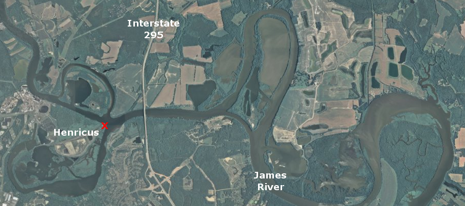
Henricus Historical Park: click on the link for 1611 Settlement
In 1611, the London Company planned to move the colonial settlement further upriver. Sir Thomas Dale selected a site that would be easy to defend near the mouth of the Appomattox River.
Why didn't Dale move all the way to the Fall Line, getting even further away from the Spanish? The area upstream was well known; in 1608, John Smith had send colonists to overwinter near Parahunt's town (now Richmond).
Further upstream from the site of Henricus, the James River narrows. Sailing ships would have spent much extra time tacking back and forth in the narrow channel, or rowing upstream.
Henricus was located in the territory of the Appamattucks, one of the tribes in Powhatan's paramount chiefdom. The Fall Line was a border zone between Siouan-speaking Monacans and other tribes under Powhatan's control. The English lacked established trading relationships with the Monacans, did not have a clear undertanding of the strength of the tribes west of the Fall Line, and could have been caught between warring groups.
Henricus was located on a bluff between Jamestown and the Fall Line, well-defended against attack by Spanish ships and protected from Native American attack by a palisade
Map Source: US Geological Survey, The National Map
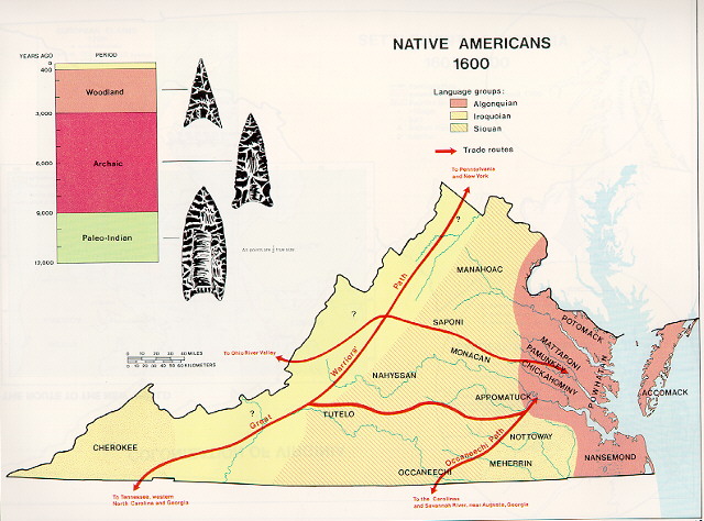
What happened to the Native Americans after the English arrived?
All tribal groups were disrupted as English colonists established new boundaries of control, and created a new legal system to define ownership through surveys and land grants. The Gingaskins on the Eastern Shore were granted a reservation - but then lost it.
The New World film was a commercial failure; the movie review site "Rotten Tomatoes" says Despite arresting visuals and strong lead performances, The New World suffers from an unfocused narrative that will challenge viewers' attention spans over its 2 1/2 hours.2
The film did stimulate interest in the Algonquian dialects, and raised questions rearding traditional interpretations of Native American words still used to identify places in Virginia.
Do you think the meanings claimed in standard textbooks for words such as Quantico, Potomac, and Chesapeake are valid? Few of the first European colonists were as careful as John Smith to study the culture of different tribes and discern the meaning of Native American words. The ability of colonists to record the correct pronunciation varied, and spelling in that time period was not as standardized as today, so we do not know the "correct" spelling or pronunciation of Potomac, Potowomek, or Potowomack. (Today, there's a standard pronuciation for local residents: Poh-toe-muck)
Tradition says "Shenandoah" means "daughter of the stars," but there is no solid basis for that interpretation. Initial conversations between English explorers and Siouan and Iroquoian tribes may have been translated through Algonquian-speaking Native Americans, muddling the meanings behind the place names west of the Fall Line or in Southeastern Virginia along the Meherrin and Nottoway rivers.
How should the heritage of Native Americans be recognized in Virginia today? The number of historic signs about Native American sites are rare compared to signs about Civil War events and characters. The debate over the name of the Washington DC professional football team is continuing, but one Virginia college resolved a similar conflict nearly a decade ago:
The poor and the ambitious in England migrated to Virginia during the 1600's, but by the end of the century the tobacco farmers needed to find a new source of labor. The dominant immigrants in the 1700's were slaves from Africa, brought unwillingly to the Western Hemisphere.
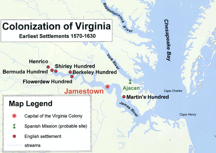
to recruit more private capital and immigrants, the London Company authorized new settlements called "hundreds"
Source: Virginia Geographic Alliance (Map 24)
Web Exercises:
Look again at John Smith's 1612 map, then compare it to modern maps at the Virtual Jamestown site. Think you could map the site you are examining for your Portfolio with equal accuracy?
- Smith stated that Virginia includes 10 degrees of latitude - and as for the west, "the limits are unknowne." He refers to what we now call the York River as the Pamaunke, and the next major stream to the north (today's Rappahannock River) as the Toppahanock. Within the boundaries of Virginia is the Pawtuxunt (today's Patuxent River). It was located in Virginia because, in Smith's time, there was no colony of Maryland.
- In his description of "5 faire and delightfull navigable rivers" on the west side of the bay, Smith failed to include the river inhabited by "a people called Sasquesahanock." He identified the Susquehanna River as a northern stream, but failed to note its large size compared to all the other streams.
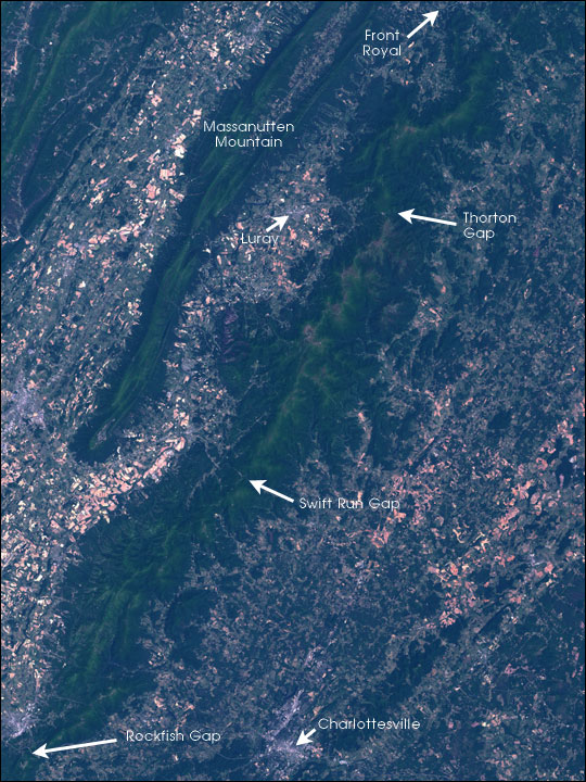
The Shenandoah Valley is divided by Massanutten Mountain (NOTE: most of Shenandoah National Park is located not in the valley itself, but in the Blue Ridge physiographic province)
Source: NASA Earth Observatory, Shenandoah National Park
Map Exercise:
Flip through the DeLorme Atlas and Gazetteer pages to sail up the James River. Start at its mouth near Hampton and go upstream to Richmond, following the path of Christopher Newport and the first English settlers in 1607.
Is Jamestown located closer to the Fall Line or to the Chesapeake Bay? Is the site of Henricus (Farrar Island in the Atlas, upstream of I-295) closer to the Fall Line or to the Chesapeake Bay? Would a move of the colonial capital to Henricus provide greater security against Spanish attack?
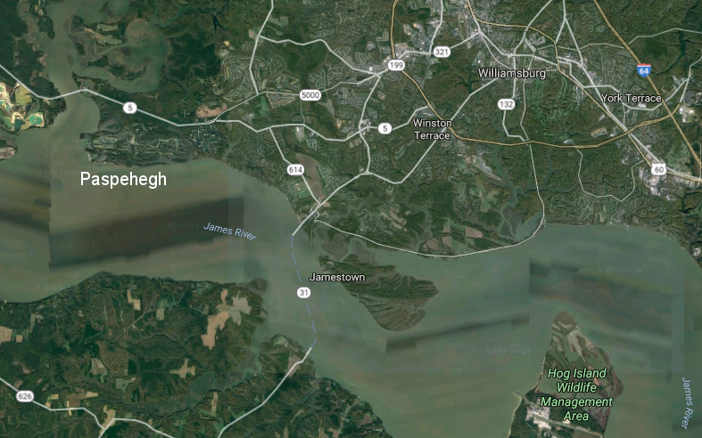
Jamestown was in territory controlled by the Paspahegh tribe. The site of their village (archeological site No. 44JC308) is now on the 18th hole of the gold course at The Governor's Land at Two Rivers retirement community at the mouth of the Chickahominy River.
Did the English at Jamestown have to row upstream or downstream to get to that Paspahegh village? Is Bermuda Hundred on the south or north side of the James River?
the Paspehegh village in 1607 is now the site of the 18th hole at The Governor's Land at Two Rivers retirement community
Source: Google Maps
Site Visit:
In previous site reports, you have identified the physical characteristics of your site. Using your understanding of how that site looked, imagine being the first colonial-era explorer to "discover" your site and plan to settle there. How would you have dealt with the Native Americans in the area?
How would you have converted the land to serve your purposes? To make a living from the land, would you have stripped the forest and planted tobacco, wheat, corn? Would you have looked at the slopes and decided to keep the forest as a source of wood, and planted crops elsewhere?
Think the first landowners to develop your site into a farm or tobacco plantation did the labor themselves - or were indentured servants and slaves from Africa/the Caribbean the first farmers and woodcutters there?
How far is your site from water deep enough to allow for transportation of your agricultural products? Would you settle for access to water just 1-2 feet deep, and carry a few items at a time to market via a canoe? Would you carve out a road from the forest to a deeper-water site (with water 4-10 feet deep), so you could load an ocean-going ship directly? If so, where would you have located a path/road to haul your crops to that waterfront site? If you built a wharf/pier from shoreline to deeper water, where would you locate that wharf? Look at the modern map, and also at historical maps of your site - was there a shipping point nearby on the water? Was there a road from your site to the river?
NOTE: Your local historical society (see list), county/city historical commission, and especially your local library will have information about early occupation and maps of your site. ask for assistance from the reference librarians. In Fairfax County, take advantage of the Virginia Room. In Arlington County, visit the Center for Local History. In Prince William, visit the RELIC center.
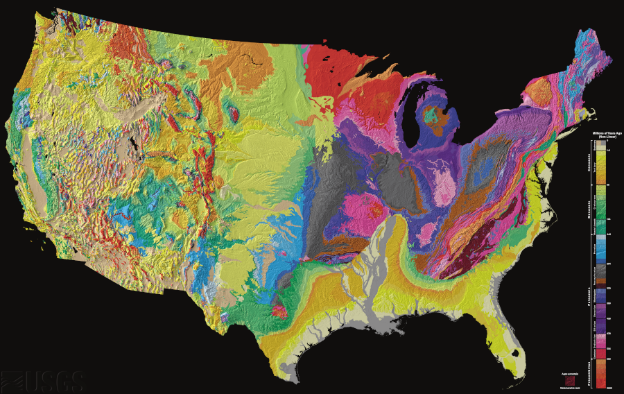
five of the physiographic regions of the United States are found in Virginia
Source: Library of Congress, "The national atlas of the United States of America," Physiographic Divisions