Assignments for Week 8: Why They Fought Where They Fought in Virginia
Control over territory ("turf") matters at times, and is often the justification for warfare. Some fighting in Virginia has been to establish exclusive control over land or water, or to eliminate the military capacity of an enemy group. At other times, conflicts have been avoided and differences resolved through negotiations.
- 10,000 years ago, how would you have communicated:
- "Ugh, hello... There's enough water and firewood for both of us to camp here tonight. We're both moving from here soon; we will hunt in different watersheds. Let's trade, let's party; let's not fight each other.
- If you want to fight, my side will win and some of you will die. I come in peace - and incidentally, do you have anyone in your group who wants to get married this weekend?"
The earliest people to occupy Virginia may have been skilled diplomats more than fighters. The Paleo-Indians were nomads, "small, mobile bands of ten to fifty people ranging across territories of up to several thousand square miles." Those traveling bands did not engage in constant warfare. Somehow, they interacted regularly enough to find mates from a different band and perpetuate the species.1
The Paleo-Indian hunting bands settled down in the Archaic and Woodland periods, establishing towns and relying upon agriculture for food supplies. The organization of Native American society changed; scattered bands of nomads evolved into stable settlements of farmers. Corn, beans, and squash provided only a portion (40-75%) of their annual food supplies. Hunting and gathering was still a necessity, especially between February-June. The stored supplies of last year's corn crop had been exhausted, but the new crops were not yet mature.
- The Iroquois tribes in New York and the Cherokee and Catawba tribes in North Carolina raided each other during the 1600's and 1700's. Their war path was along the Blue Ridge, and Route 15 today roughly follows the Shenandoah Hunting Path.
- After the 1722 Treaty of Albany, the Iroquois agreed to stay on the west side of the Blue Ridge. They used a route now followed by I-81.
- In 1744, the Iroquois relinquished their claims to the Shenandoah Valley in the Treaty of Lancaster. Thomas Jefferson's father recorded that the 1744 treaty authorized the Iroquois to keep using their path west of the Blue Ridge.
- The long-distance raids required a lot of walking, with an occasional stop for catching a meal. There were no interchanges with gas stations selling Made To Order meals.
- The raids did not occur in February-June, when food supplies were lowest. Most raids were in October-December, when the Iroquois had enough food to "pack a lunch for the trip" and hunting was best. The timing of warfare was tied to the availability of food.
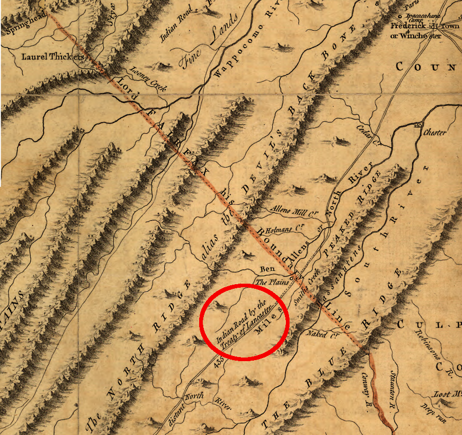
in 1744, the Treaty of Lancaster authorized the Iroquois to keep traveling through the Shenandoah Valley, west of the Blue Ridge
Source: Library of Congress, A map of the most inhabited part of Virginia containing the whole province of Maryland with part of Pensilvania, New Jersey and North Carolina (by Joshua Fry/Peter Jefferson, 1751)
- How the Native Americans Greeted the English in April-May, 1607
- Did those English arrive in territory under Powhatan's control?
- Cape Henry Memorial
- Was military defense the first priority of the English when they arrived? According to George Percy, what did the English do first?
- What did the Native Americans do when they first saw the tassantassas (strangers) - try to trade fresh food for iron/copper?
- Think fighting over territory has been a part of the Virginia story since Paleo-Indian hunting bands were roaming the countryside 15,000 or more years ago?
- After landing at Cape Henry on April 26, the colonists assembled a shallop (a barge or a small boat brought from England in pieces as cargo) and explored across the bay. When they found a place where the channel was deep, minimizing the risk that their ships would run around, they named it Point Comfort.
- contrast the development around Cape Henry over time
- Where is Cape Henry, in relation to Cape Charles?
- Where is Cape Henry, in relation to False Cape State Park?

"The first land they made they called Cape Henry; where thirtie of them recreating themselves on shore,
were assaulted by five Salvages, who hurt two of the English very dangerously..."
(first English landing in Virginia at Cape Henry, 1607)
Source: John Smith, The generall historie of Virginia, New England & the Summer Isles, together with
The true travels, adventures and observations, and A sea grammar - Volume 1 (see p. 87)
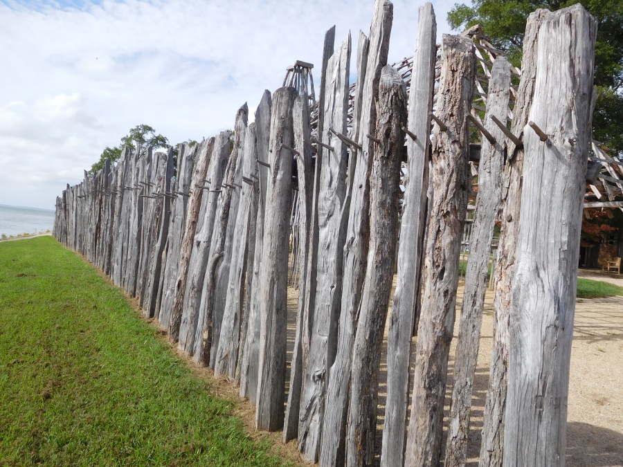
- At Jamestown, the English built a triangular fort for defense.
- A map showing the fort was produced by John Smith or his cartographer in England, based on his description. A Spanish spy obtained it, and it lay hidden for centuries in the Spanish archives.
- The main gate faced towards the James River, not towards the land. The English focused on access to their ships; rivers were highways rather than barriers in the colonial era - especially for the English. The walls of James Fort provided defense, without the weakness of a gate, on the two sides facing the land.
- The James River has eroded away 100 yards of the upstream edge of Jamestown Island, and for decades everyone assumed the site of the fort was lost - but in 1994 archeologist William Kelso found the site.
the English took only 19 days to build their triangual fort, with a wooden palisade 100 yards long on two sides and 140 yards long on the third
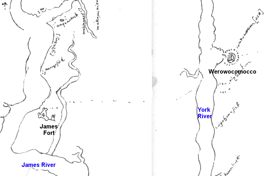
Ambassador Zuniga's spies copied what may be John Smith's 1608 map, showing the capitals of English colonists ad Powhatan's paramount chiefdom
Source: Encyclopedia Virginia, Zúñiga Chart
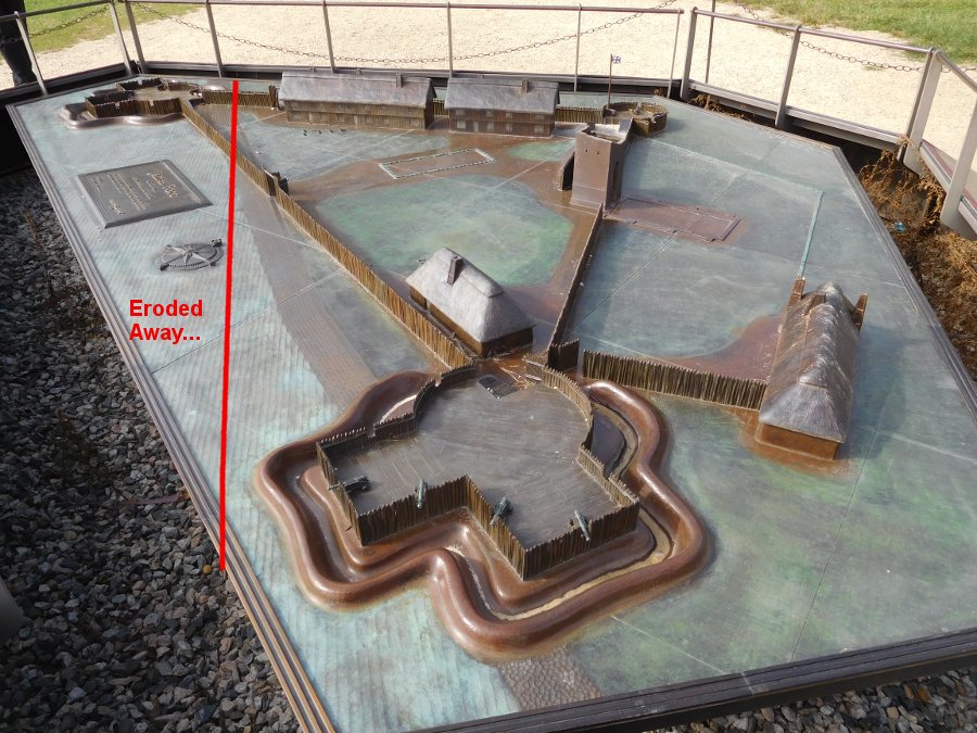
the James River eroded away one bulwark of the fort, where cannon were placed to defend against Spanish, Dutch, or French ships
- The First Anglo-Powhatan War (1609-13)
- The Second Anglo-Powhatan War (1622-32) and the Wooden Wall Across the Peninsula
- The Third Anglo-Powhatan War (1644-46)
- What were the boundaries of Tsenacommacah? Remember from previous classes how the Fall Line shaped Powhatan's area of control...
- When the English arrived at the eastern edge of Virginia, they encountered a society based on a paramount chiefdom, where Powhatan could command warriors and collect taxes in Tsenacommacah from over 30 tribes... and thought that he could outmaneuver the English until those tassantassas (strangers) abandoned their colony.
- Do you think "Chanco" was a patriot or a traitor?
- After the Second Anglo-Powhatan War, the English built a wooden palisade and expelled the Native Americans from the southern tip of the Peninsula, from Middle Plantation Williamsburg) to Hampton. You can identify the primary area of English settlement 15 years after Jamestown started, based on the location of that wall.
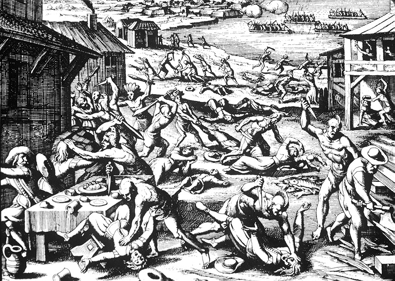
how the March 22, 1622 uprising led by Opechancanough was portrayed in Theodore DeBry's engraving
the artist created this woodcut based on reports from Virginia... but do you think he used his own imagination as well? For example, think he manufactured the idea that the Indians attacked fortifications in canoes, like the Spanish would have attacked in ships?
Source: Indians of North America - Theodore De Bry Woodcuts
- The "War Aims" of Powhatan and the English
- the marriage of John Rolfe and Pocahontas resulted in a brief end to Anglo-Powhatan warfare
- Pocahontas, with husband and child, was shipped to England in 1616 as an exhibit. Virginia Company investors needed to boost sales of stock, and "Pocahontas-turned-into-Rebecca" was expected to generate buzz - except she died on the trip home in 1617 and was buried at Gravesend in England.
- John Rolfe remarried after Pocahontas died, and he died in 1622 (we do not know how; he may have been killed in the uprising)
- Thomas Rolfe (son of Pocahontas, grandson of Powhatan) stayed behind in England after his mother died in 1617, but returned to Virginia as an adult
- many politically-powerful First Families of Virginia (FFV's) trace their lineage through Thomas Rolfe back to Pocahontas - affecting how Virginia implemented racial segregation in the 1900's
- look at the Patterns of Settlement Map, and compare the locations of Native American towns to the boundaries of the first counties created in 1634.
- did the General Assembly define county boundaries so they included any Native American towns located north of the Rappahannock River? York River?
- The Military in Colonial Virginia - an International Frontier
- First Forts At Point Comfort
- Fort Monroe
- Fort Wool
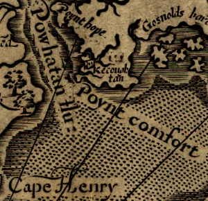
in the 1800's, Fort Monroe was built at the site John Smith mapped as "Point Comfort"
Source: Library of Congress, Virginia / discovered and discribed by Captayn John Smith, 1606
- Bacon's Rebellion
- Virginia had a civil war in 1676 known as Bacon's Rebellion. The relatively-poor farmers living on the northern and western edges of Virginia's settled areas thought the colonial elite in Jamestown were too concerned with maintaining their fur trading deals with the Native Americans, and not concerned with protecting the colonists living in the borderlands.
- Governor Berkeley and his allies in the General Assembly were imposing excessive taxes, but the members of his Council of State (the richest planters in the colony) were exempt and did not have to pay those higher taxes. Bacon also refused to call for new elections to the House of Burgesses, so the majority of colonists had no peaceful option for redirecting the colony's government.
- Bacon's Rebellion was a civil war triggered by income inequality and a growing sense of frustration that change was being blocked by the incumbent elite in government.
- Nathaniel Bacon demanded that the governor give him a military commission him to lead the militia against the Native Americans in Northern Virginia, who were accused of murder and theft in Stafford County. The governor refused and boldly challenged Bacon to shoot him dead on the steps of the Statehouse in Jamestown. Instead, Bacon told his rebels to aim at the members of the House of Burgesses - and he quickly got his commission.
- Bacon led his army against the peaceful Pamunkey and Occoneechee, which had a fur trading center at the site of modern Clarksville on the Roanoke River. After robbing and killing Native Americans who were not responsible for attacks in the backcountry, Bacon's rebels returned to Tidewater.
- They occupied the plantation homes of the wealthy and drank the wine stored in the cellars, then returned to Jamestown. Governor Berkeley abandoned the colonial capital, and Bacon's rebels burned it. The governor fled to the Eastern Shore. (Sound familiar? Governor Francis Wyatt had fled across the Chesapeake Bay for six weeks in 1622)
- The rebels who followed after him were defeated, and then Bacon died of the "bloody flux" (perhaps dysentery). With the help of the tobacco ship captains who had cannon on their ships and were loyal to the Tidewater gentry, Governor Berkeley recaptured the colony.
- He was harsh in victory, and seized all the property of many rebels. Among Bacon's rebellious allies was William Drummond, a member of the gentry and a personal enemy of Berkeley. Drummond had been governor of North Carolina (Lake Drummond is named for him). After Drummond was captured, Berkeley greeted him with a malicious "Mr. Drumond! you are very welcome, I am more Glad to See you, than any man in Virginia, Mr. Drumond you shall be hang'd in half an hour." In fact, Drummond's trial did not occur until six days later, but he was hung within several hours of his conviction.2
- King Charles II is reported to have been surprised at Berkeley's executions, saying "That old fool has hanged more men in that naked country than I have done here for the murder of my father." Charles recalled Berkeley to England, where the governor died.3
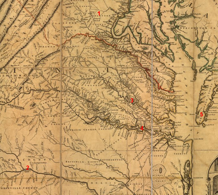
Bacon's Rebellion was sparked by an overseer's murder in Stafford County (1), but Bacon led his rebel army against peaceful Occoneechee at their fur trading post on the Roanoke River (2) and the peaceful Pamunkey (3), then burned Jamestown (4) while Governor Berkeley fled to the Eastern Shore (5)
Source: Library of Congress, A map of the most inhabited part of Virginia (Joshua Fry and Peter Jefferson, 1755)
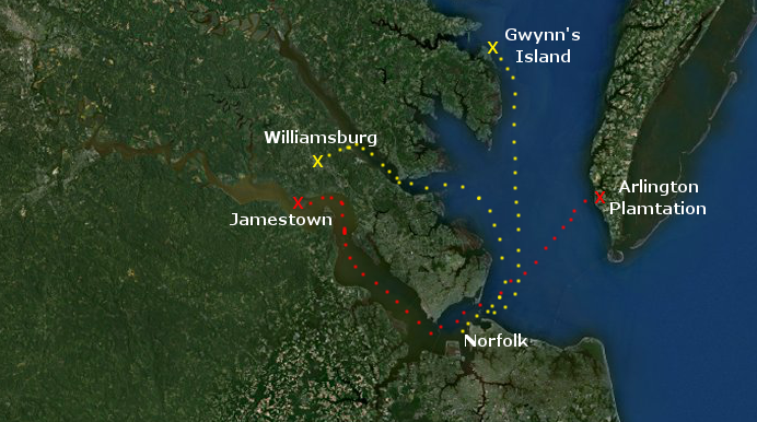
To avoid capture by Nathaniel Bacon's army, Governor Berkeley fled from Jamestown to the original Arlington Plantation, owned by John Custis in Northampton County (route in red). In 1676 the British officials appointed by King Charles II ended up defeating the rebellious colonists. A century later, Lord Dunmore fled Williamsburg at the start of the American Revolution, to attack Norfolk and then to his final base at Gwynn's Island (route in yellow).
Map Source: US Fish and Wildlife Service Wetlands Mapper
- The Chesapeake Bay: Avenue for Attack
- Pirates in Virginia
- Colonial Williamsburg interpreters tell the story of how Blackbeard's head was hung from a pole at Hampton, and ultimately his skull became a silver-plated drinking cup with "De[a]th to Spotswoode" engraved on it.4
- Governor Spottswood sent Virginia's military forces across the border into North Carolina, where the governor was thought to be conspiring with the pirates
- Virginia sent military forces outside the boundaries of the colony to kill Blackbeard, and also to:
- destroy the French settlement at Port Royal (in Acadia) in 1613
- defend Charleston, South Carolina in the Revolutionary War (the Virginia Line of the Continental Army was captured at Charleston in 1780)
- invade Maryland in 1862 and Pennsylvania in 1863
- ...but when General Braddock marched west to Fort Duquesne in 1755 during the French and Indian War, Virginia officials claimed that the future site of Pittsburgh was still within the boundaries of Virginia...
to stop Blackbeard's piracy, Governor Spotswood treated the North Carolina border as if it did not exist
Source: ESRI, ArcGIS Online
- prelude to the French and Indian War
- The Iroquois tribes managed to block the Huron, Shawnee and other northern/western tribes from trading directly with the Dutch at Fort Orange on the Hudson River, or with the French in Montreal on the St. Lawrence River. Being the essential middlemen in all trade ensured the Iroquois profited, as European colonization advanced from the Atlantic Ocean inland.
- When the English seized the Dutch colonies in North America, Fort Orange was renamed Albany - but the Iroquois continued to control the fur trade. The Susquehannocks in southeastern Pennsylvania were displaced by colonial settlement and then aborbed by the Iroquois, who became the dominant Native American group north of the Potomac River.
- The French claimed the Ohio River valley, and started to occupy it in the late 1740's. The land-hungry Virginia colonial leaders feared that an alliance between the French and various Native American tribes would block the English from establishing settlements west of the Allegheny Front.
- Tobacco exhausted the soil. Virginians assumed they needed to keep moving west, clearing the forest and creating new farms. If the French blocked that migration, then the French needed to be evicted from the Ohio River Valley.
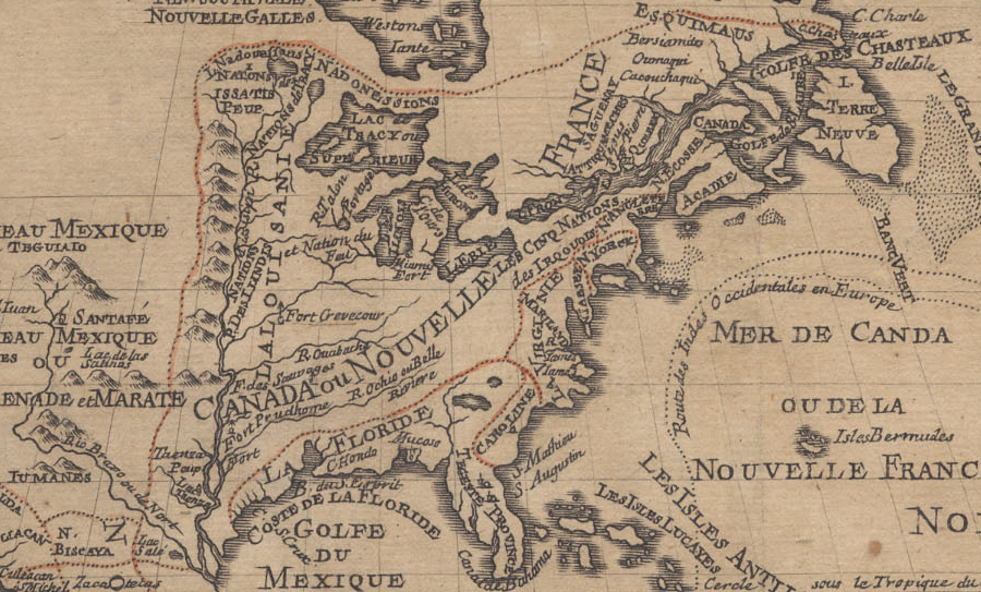
the French, English, Dutch, and even Swedes competed over the trade for furs between the Chesapeake Bay and St. Lawrence River, while the Five Nations of the Haudenosaunee ("Les Cinque Nations des Irquouis") ended up dominating their neighbors and gained control over the trade for weapons prior to the French and Indian War
Source: University of California - The Bancroft Library, L'Amerique septentrionale
- Allegheny Expedition (George Washington's Mission to the Ohio River in 1753)
- In 1753, George Washington was a 21-year old man struggling to define himself and his role in the world. George never attended a formal school for a single day, but he invested substantial time in learning to be a surveyor and to develop his social graces. (Yes, he was an excellent dancer...) His friend George William Fairfax and his wife Sally at the Belvoir plantation helped him, but George was seeking an opportunity to "make his mark" when the French began to occupy the Ohio River Valley.
- Washington volunteered to carry Governor Dinwiddie's "get out of my back yard" message to the French, who had set up their base near Lake Erie. It was a dangerous expedition in the middle of the winter, and when he returned Washington made sure everyone knew it. He wrote a report of the journey that went viral, and his military career was launched.
- In 1753, Virginia was willing to fight for its western land claims, which were based on the Second Charter issued in 1609. At the start of the French and Indian War, Pennsylvania was not; its legislature was controlled by pacifists, especially Quakers.
- In the Revolutionary War, the Virginia militia under George Rogers Clark - not the Continental Army - won key victories in the Illinois Country. The militia's success caused the British to agree in the 1783 peace treaty that the new United States of America would own the land westward to the Mississippi River, not just to the Ohio River/Allegheny Mountains.
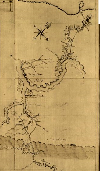
George Washington's hand-drawn map of his trip to Fort Le Boeuf in 1753, to warn the French to leave the Ohio River valley
Source: Library of Congress, George Washington's map, accompanying his "journal to the Ohio", 1754
- The French and Indian War
- Don't try to figure out all the zigging and zagging between the French, Dutch, and English in Canada and New York since 1540, but recognize that competition between different colonies and European nations had preceded the fight over the Ohio River Valley.
- Starting in the 1710's, Governor Spotswood and then Governor Gooch had encouraged immigrants from Europe to settle in the Shenandoah Valley. The Virginia officials welcomed French and German refugees who were Protestants but not Anglicans, figuring that diversity was better than delaying settlement until the English population in Tidewater/Piedmont grew enough to settle the lands across the Blue Ridge.
- Governor Spotswood and Governor Gooch were not political liberals encouraging religious diversity. The King of England was also the head of the Anglican Church, so inviting non-Anglicans into the colony created the risk that the new immigrants west of the Blue Ridge would not be 100% loyal to the colonial government. So, why do it?
- From Spotswood's and Gooch's point of view, it was better to fill the Shenandoah Valley with less-than-perfect Europeans who owned their land thanks to "patents" (land grants) issued from Williamsburg, than to let the valley fill up with people who might be friendly towards the French.
- By the 1750's, the French still sought profits in North America primarily through fur trading. The English expected to get rich from agriculture, tobacco agriculture exhausted soil fertility, so the Virginians were constantly speculating in western lands because existing tobacco plantations would have to be idled/abandoned.
- The Virginia gentry recognized that their land speculation ("land hunger") northwest of the Ohio River would be blocked, if the French built settlements along the Ohio River to link their Canadian settlements with their Louisiana settlements.
- Land claims by Virginia speculators to the Ohio country were based on deeds filed in the public records office in Williamsburg, grants issued by the governor, and acts passed by the General Assembly. If the French ended up controlling of the Ohio River watershed, those English documents would become irrelevant and the colonists' "land hunger" would go unsatisfied.
- The French and Indian War may have been caused fundamentally by land speculation, but the "assassination" of a French diplomat by George Washington's Native American allies at Jumonville Glen helped spur international rivalry into a shooting war
- Braddock Road in Northern Virginia was not built by the British to haul artillery to the Forks of the Ohio. That road may have gotten its name in the 1750's because it was used by Northern Virginia farmers bringing supplies to Alexandria, before General Braddock crossed the Potomac River and marched through Maryland into history.
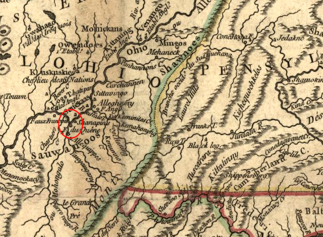
Forks of the Ohio, from the French perspective in 1755
Source: Library of Congress Partie de l'Amérique septentrionale, qui comprend le cours de l'Ohio, la Nlle. Angleterre,
la Nlle York, le New Jersey, la Pensylvanie, le Maryland, la Virginie, la Caroline
(note how Pennsylvania/Virginia border west of Maryland is undefined)
- The Proclamation Line of 1763
- King George III's officials back in England said "let's not stir up the Native Americans; keep away from their land, and we can avoid expensive military responses - so Virginians, KEEP OUT!"
- The Virginians were willing to use their militia on the frontier to maintain control over lands in the Ohio River watershed, especially if British troops might do some of the fighting and subsidize some of the costs.
- The royal officials in the colonies, including the governors of Virginia, supported settlement west of the Proclamation Line - once treaties were negotiated with theNative Americans. In theory, those negotiations would result in peaceful, inexpensive, no-troops-required settlement on western lands.
- The Revolutionary War in Virginia
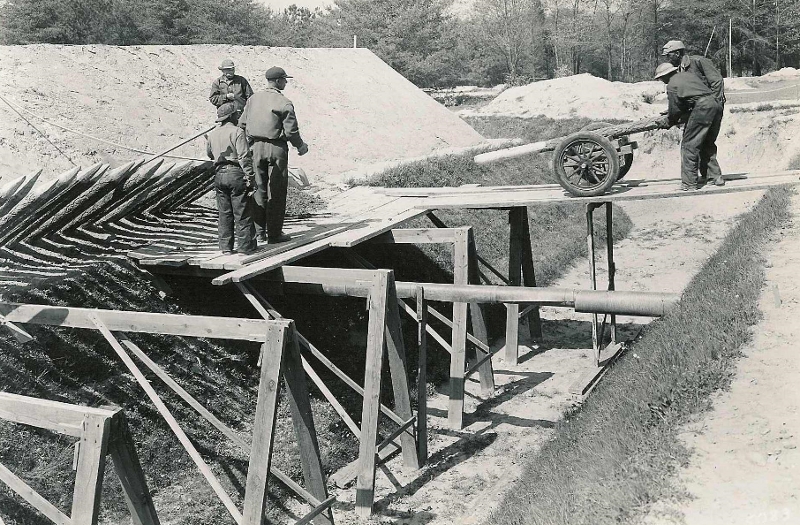
Civilian Conservation Corps reconstructing Revolutionary War earthworks at Yorktown, after 150 years of erosion
Source:
National Park Service
- Were the Virginia Slaves Loyalists or Revolutionaries in the Revolutionary War?
- Dunmore made a conscious choice to disrupt colonial society and transform the status of the slaves, in order to increase the potential of English control over the colony. Imagine how he would have dealt with those slaves if the English had succeeded in defeating the rebels. George Washington, Thomas Jefferson, and Patrick Henry may have been hanged as traitors - but do you think the slaves would have been granted any rights beyond freedom? Think the English would have accelerated the push for equal rights, or would Virginia have been a society segregated by color even if the English had won?
- George Washington was desparate for soldiers, and free blacks (as opposed to slaves) were welcomed into the ranks of the Continental Army. According to one French officer in 1781, when George Washington's army started its march from New York City to Yorktown, it was an integrated army and 25% (1,200-1,500 out of 6,000 men) were black.5
- Why Was Virginia a Military Target in 1781?
- The capital of Virginia was moved from Jamestown to Williamsburg in 1699, after the Statehouse in Jamestown burned. Virginia moved its capital again from Williamsburg to Richmond in 1780, during the American Revolution. Moving the capital in 1780 shifted it further away from the British - but the James River was an avenue of attack, and Richmond was still well within reach of the British warfleet in 1781.
- The General Assembly fled from Richmond to Charlottesville in 1781 to escape an invading British force. While at Cuckoo Tavern in Louisa County, Jack Jouett discovered that the British had not stopped in Richmond. Colonel Tarleton and his raiders were on their way to capture governor Thomas Jefferson and other rebels in Charlottesville. Jouett rode through the night, as the Virginia equivalent of Paul Revere. Jouett got permanent scars from branches that whipped across his face in the dark, but he provided warning in time. The General Assembly fled further west, across the Blue Ridge, and reassembled at Trinity Church in Staunton. There, Jefferson's term expired and a new governor was elected.
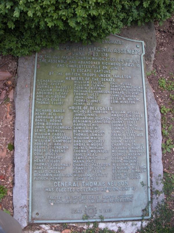
plaque at Trinity Church commemorating when General Assembly met in Staunton
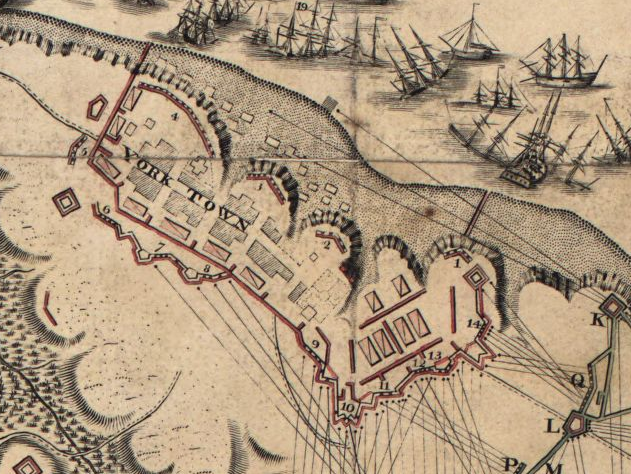
French brought cannons that destroyed Cornwallis's fortifications at Yorktown - and a storm blocked his attempt to escape across the York River
Source: Library of Congress, plan of the investment of York and Gloucester
- Norfolk Naval Shipyard
- Craney Island
- In the War of 1812, the navy yard at Portsmouth was a target of the British Navy. Americans quickly built a small fort at the mouth of the Elizabeth River on Craney sland - and successfully blocked a British assault in 1813.
- The Americans were less successful on the Potomac River. 200 years ago in 1814, British troops marched through Maryland, defeated a rag-tag American force at Bladensburg, and burned the public buildings in Washington DC. At the same time, British warships sailed up the Potomac River and captured Alexandria without a fight. The only defensive fort was on the Maryland shore, and the American commander abandoned it rather than fight.
- The most effective way to protect Washington, DC from attack turned out to be blocking any enemy forces from getting into the Chesapeake Bay.
- The 1861-65 Civil War was fought across Virginia.
- Wilmer McClean was upset that his Yorkshire plantation south of Centreville was the scene of skirmishes in July, 1861, two days before the first battle at Manassas. He moved as far away as he could from the theater of war around Washington DC, settled in Southside Virginia, built the biggest house in a small farming community, and tried to avoid the fighting. Ironically, four years later it was his big house in the isolated community of Appomattox Court House that was chosen for the formal surrender of the Confederate Army of Northern Virginia in April, 1865.
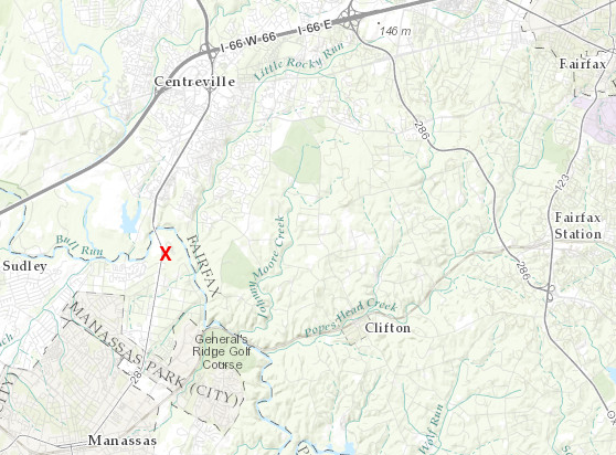
Wilmer McClean lived at Yorkshire (red X) in 1861
Source: ESRI, ArcGIS Online
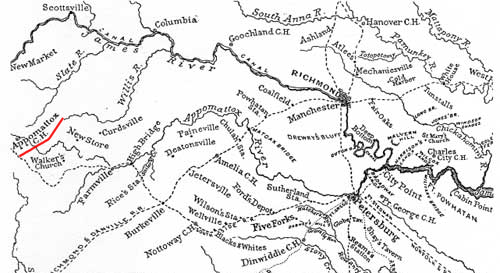
at the end of the Civil War, Confederate General Robert E. Lee attempted to move from Petersburg to North Carolina to continue fighting the war, but Union forces blocked his retreat and he surrendered the Army of Northern Virginia at Appomattox Court House - in Wilmer McClean's new house
Source: National Park Service, The Campaign to Appomattox
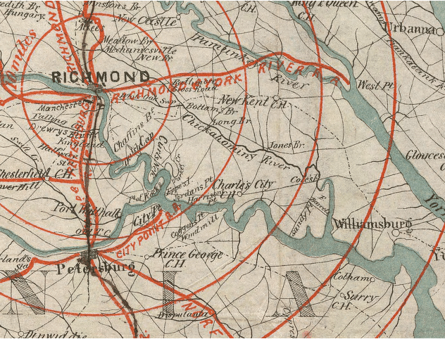
- Map of the Virginia Railroads at the Start of the Civil War
- map at start of First Bull Run Campaign
- note that no railroad goes directly south of Alexandria. A road connected Falmouth/Fredericksburg with Alexandria, but the Richmond, Fredericksburg and Potomac (RF&P) railroad dead-ended on Aquia Creek.
- The Orange and Alexandria (O&A) Railroad went south of Manassas to Gordonsville, where it connected with the Virginia Central - which did reach Richmond. A Union army marching to Richmond could use the O&A/Virginia Centrail railroads to carry supplies all the way from Alexandria to the capital of the Confederacy... assuming the Union army could defeat the Confederates and take control of the railroad.
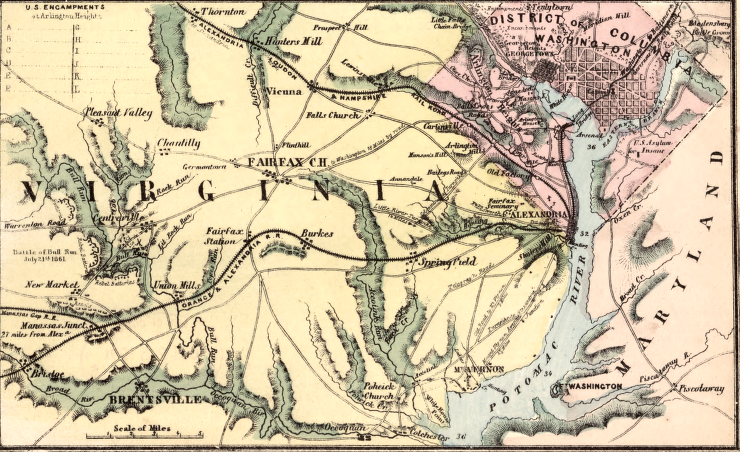
Orange and Alexandria (O&A) and Alexandria, Loudoun and Hampshire (A,L&H) railroads connected Alexandria to the Piedmont,
but no railroad ran south through the Coastal Plain to Fredericksburg and "on to Richmond" until after the Civil War
Source: Library of Congress,
Topographical map of Virginia between Washington and Manassas Junction (1861, probably)
- On to Richmond in 1862: The Peninsula Campaign
- Union General McClellan came within a few miles of Richmond, until Confederate victories in Seven Days battles triggered him to make a "change of base," retreating to Harrison's Landing on the James River. That retreat alerted General Lee on the Confederate side that the Union army under General McClellan would be defensive rather than agressive, so Lee marched north and invaded Maryland in September 1862.
- It is an old saying that "armies travel on their stomach." Soldiers win battles, but logistics win wars. The geography of military actions, and the answer to the "why did they fight there?" question, is often a reflection of transportation geography.
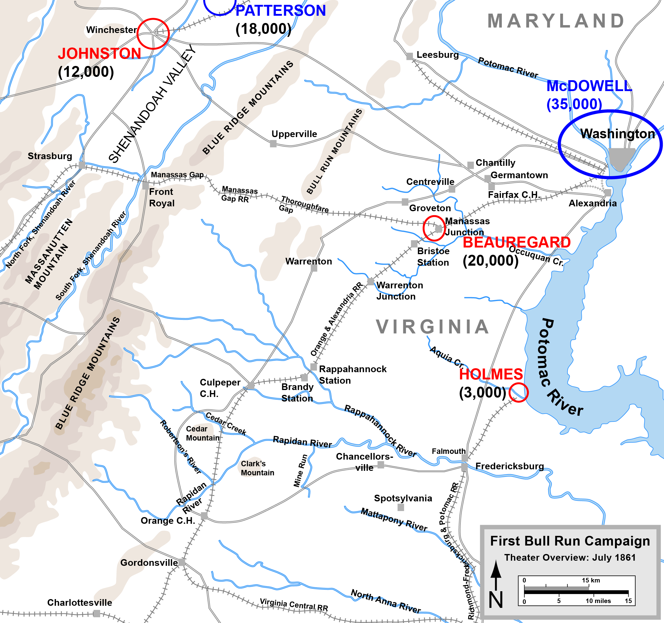
- In 1861 the Union Army was headed south 100 miles to Richmond - but at the start, it took a 30-mile detour to the west. The only railroad line that could carry supplies between the Potomac and James rivers went through Manassas Junction. The generals calculated that horses and wagons could not carry enough stuff. The Union Army was willing to go off the direct route to Richmond in 1861, and again in 1862, because access to food was essential.
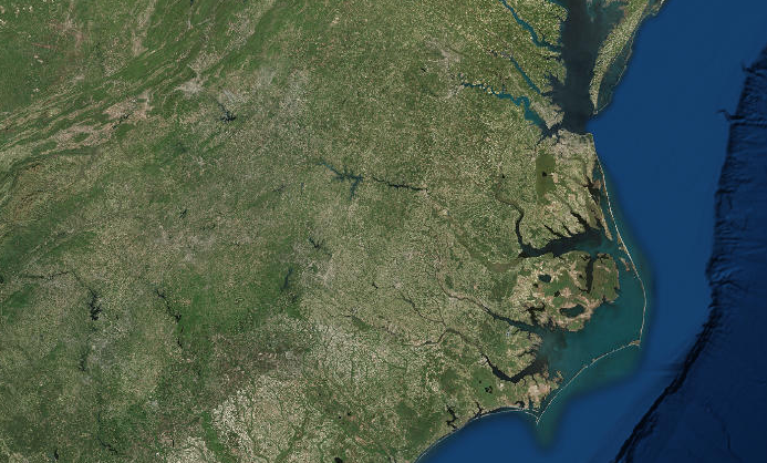
- Why didn't the Union Army march south down the Shenandoah Valley towards Richmond? After all, Confederate General Early attacked DC in 1864 after marching through the valley.
- The Blue Ridge is not a north-south mountain range. It runs northeast-southwest, and that made the difference:
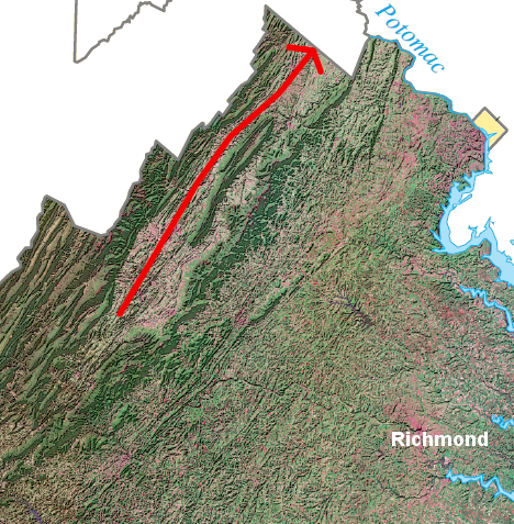
Confederates moving down the valley to the north (red line) came closer to the Union capital in Washington DC, but Union forces moving up the valley moved southwestward - away from the Confederate capital at Richmond
Source: US Geological Survey (USGS), Satellite View - Virginia
- Where armies fought in Virginia was determined by both territorial objectives (what were the armies trying to capture?) and the logistics of supplying those armies. The sites of many battles were determined by transportation corridors, explaining why empty farmland with no obvious value often became a bloody battleground.
- One patch of ground that became the site of an especially harsh battle was low-value woodland in Spotsylvania County. Trees had been harvested and converted to charcoal to smelt iron ore at Catharine Furnace. The land was abandoned afterwards.
- The woods were thick with young trees and brush, regrowing after the mature forest had been cut down for fueling the iron furnace.
- When the Union forces crossed the Rappahannock River and started marching "On to Richmond" in May, 1864, Robert E. Lee chose to fight in those woods because the value of the Union artillery was limited by the trees. The site of that battle is now known at the Wilderness Battlefield.
- The Union Army had tried three previous times, in 1861, 1862, and 1863, to capture the Confederate capital at Richmond. Each time, Confederate defenders had blocked Union advances. In 1864, the Union general (Ulysses S. Grant) was also blocked by the Confederate Army of Northern Virginia led by General Robert E. Lee - but unlike his predecessors, Grant chose to keep going rather than to retreat.
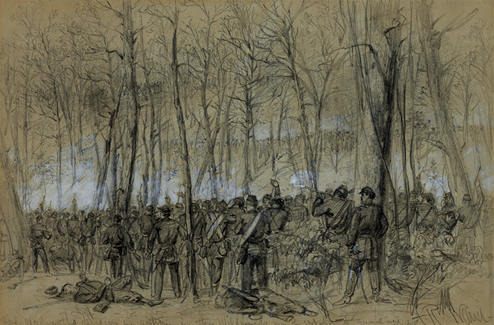
the woods caught fire at the Battle of the Wilderness, burning to death some of the wounded who could not flee
Source: Library of Congress, Genl. Wadsworths Division in Action in the Wilderness, near the Spot Where the General Was Killed
- How Virginia Split Into "East" and West Virginia (But With Only Three Shenandoah Valley Counties, and Without Southwest Virginia)
- Virginia-West Virginia Boundary
- Virginia was the only state to lose territory as a result of the Civil War. Did that occur as punishment during Reconstruction between 1865-70, imposed by the US Congress to weaken Virginia's capacity to rebel again in the future - or were there strong sectional rivalries in Virginia that preceded the war?
- Kentucky entered the Union in 1790. The US Constitution required approval from Virginia before the state could be divided, and the Virginia leaders in Richmond supported creation of Kentucky. Since the Virginia leaders in Richmond clearly did not support creation of West Virginia... how could the US Congress claim that the Commonwealth of Virginia had agreed officially to the creation of West Virginia?
- Most of the Virginia counties on the Appalachian Plateau chose to form a new state when the Civil War created the unexpected opportunity. Did those counties want to separate from Virginia in order to create a new state that would ban slavery? Why else would they want to be independent of the legislature and governor in Richmond?
- The Military in Virginia
- In the 1622 and 1644 uprisings, the Native Americans attacked lightly-defended houses rather than the fort at Jamestown.
- In the American Revolution, the British captured the capital at Richmond (finding almost no public buildings to burn...) and chased the General Assembly all the way to Staunton, but the key battle was offshore. The French fleet drove the British fleet away from the Chesapeake Bay, and Cornwallis was trapped without supplies or an escape route from Yorktown.
- In the Civil War, the primary Union objective was the Confederate capital at Richmond. While battles occured as far away as Cumberland Gap, Saltville, and Radford (called "Central Depot" in 1864), the Union campaigns in 1861-65 were designed to capture the capital on the Fall Line.
- So How Do We Describe Military Conflicts Without Igniting Passions Again
- After Robert E. Lee surrendered his Confederate army at Appomattox in 1865, a crowd gathered on the White House lawn. President Lincoln called for a band to play Dixie, saying "I have always thought 'Dixie' one of the best tunes I have ever heard. Our adversaries over the way attempted to appropriate it, but I insisted yesterday that we fairly captured it."6
- The "Confederate flag" became a symbol of resistance to civil rights in the 1950's and 1960's. If that flag was flying on the lightpoles of Lexington, think the total number of tourists visiting that town would increase or decrease?
- Camp Pendleton
- the Virginia militia has left a legacy...
City Point, supply base for the Union armies during siege of Petersburg in 1864-65, was once part of the Charles City County
Source: Library of Congress, Map of eastern Virginia and North Carolina : from the United States Coast Survey (1864)(April, 1865)
Web Exercise:
No Web Exercise this week; since so much other content already assigned.
Map Exercise:
Check out the Library of Congress's online version of a Map of eastern Virginia, showing railroads in Virginia during the Civil War.
You already know that the Union forces marched to Manassas first in 1861, rather than due south to Fredericksburg, so the army could use the rails to supply troops/horses marching to Richmond. Trace the route of the Orange and Alexandria Railroad southwest to Gordonsville, then follow the Virginia Central southest to Richmond. Then look at the Shenandoah Valley - did any railroad provide a potential supply line for invading Union forces going from the Potomac River south through Winchester, Harrisonburg, Staunton, all the way to Lexington?
Video:
No video this week
Site Visit:
What military activity has occurred at your site? How would you describe potential frontier encounters between bands of Paleo-Indians, or English colonists and Native Americans in the Contact Period? Think the French army marching to Yorktown - or back - would have foraged for fresh food at your site? Did soldiers in the Civil War march nearby, or camp nearby?
Now imagine you are in 1864, and Mosby's Rangers (a cavalry force of legitimate but "irregular" troops fighting for the Confederacy) are about to visit your site. Use your imagination, as well as any history you may have learned about your community, to describe:
- how your site would have looked in 1864 (was it an untamed wilderness? were there farm fields planted in corn, or hayfields with grass? any hills or ravines nearby that might have been hard to farm, so those places were managed as woodlots with trees generating firewood and fence posts? would you have seen some of the same roads that are used today? what sort of houses were there... and where were the stables? were there slave quarters nearby?)
- if a band of 20 mounted cavalry road into your neighborhood, looking to quickly attack a Yankee outpost or camp and then flee... from what direction would Mosby's Confederates have arrived? would they leave the same way, or escape in a different direction?
- if Yankee reinforcements were sent to the scene, can you describe how they might have arrived? use your imagination - think the reinforcements came fast and furious on horses, bracing for a fight with Mosby... or would they have marched slowly as dismounted infantry, with scouts in front carefully checking for any possible ambush but resulting in slower-than--normal-walking-pace progress?
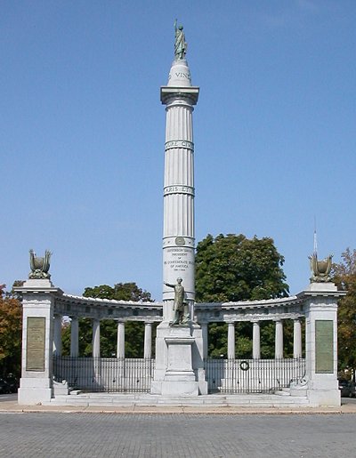
statue honoring Jefferson Davis (president of the Confederate States of America) on Monument Avenue in Richmond
References
1. "Bay and Piedmont: A Landscape History of the Chesapeake Heartland from 1.3 Billion Years Ago to 2000," Chesapeake Bay Program, September 2000, p.23, http://archive.chesapeakebay.net/pubs/gateways/plainandpiedmont/HF-CH2.pdf (last checked October 5, 2014_
2. "William Drummond," Encyclopedia Virginia, http://www.encyclopediavirginia.org/Drummond_William_d_1677 (last checked October 13, 2012)
3. Virginia: a guide to the Old Dominion, Virginia Writers' Project, 1950, p. 42, http://books.google.com/books?id=PBBAaN0aDicC (last checked October 13, 2012)
4. "When Blackbeard Scourged the Seas," Colonial Williamsburg Journal, Autumn 1992, http://www.history.org/foundation/journal/blackbea.cfm (last checked October 7, 2014)
5. Robert A. Selig, "The Revolution's Black Soldiers," http://www.americanrevolution.org/blk.html (last checked October 13, 2013)
6. Michael Burlingame, Abraham Lincoln: A Life, JHU Press, 2012, p.1038, http://books.google.com/books?id=UrCBLHGyM3sC (last checked October 5, 2014_
Syllabus and Class Schedule for Geography of Virginia (GGS 380)
Geography of Virginia (GGS380)
Virginia Places