George Washington and Jefferson National Forest Cultural History
where was the first American iron works erected ?
what are the essentials for the location of a furnace?
what was the collier's enemy?
what were the three main raw materials needed for the successful operation of charcoal ironworks?
Virginia's iron industry continued after the Civil War, but could not compete after discovery of the rich ore in northeast Minnesota (Mesabi Iron Range)
Search for Virginia places with "furnace" in the name at Geographic Names Information System - how many are there? If you check the Exclude Variants box, does the total change significantly?
was there iron ore in the bedrock east of the Blue Ridge, or was all the raw ore hauled across the mountains to the furnaces built on in Piedmont physiographic province?
The area near this particular Catharine Furnace was called the "Wilderness," because the woods presented such a tangle of low branches to anyone trying to travel through that area. Wounded soldiers burned to death, after the woods caught fire during a Civil War battle. For what reason were those woods in an early stage of regrowth in 1864?
the tangle of trees that replaced the original trees around the Catharine Furnace (which were converted into charcoal) gave the name to the May, 1864 Battle of the Wilderness
Source: Library of Congress, Wounded escaping from the burning woods of the Wilderness
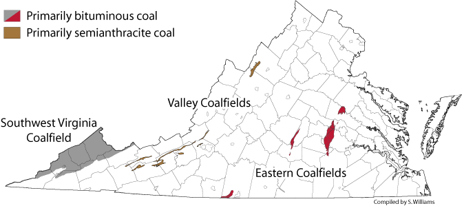
Coal is located on the Appalachian Plateau, but also in the Triassic Basin at Richmond and in the Valley and Ridge physiographic province.
Compare map 1 and map 2. Two counties in the Shenandoah Valley, Rockingham and Augusta, are omitted from map 1 - though coal may be present, it is not economical to mine the small quantities.
In the past, coal production has been significant for the local economy in all three physiographic provinces. Today, only the mines on the Appalachian Plateau mines are working.
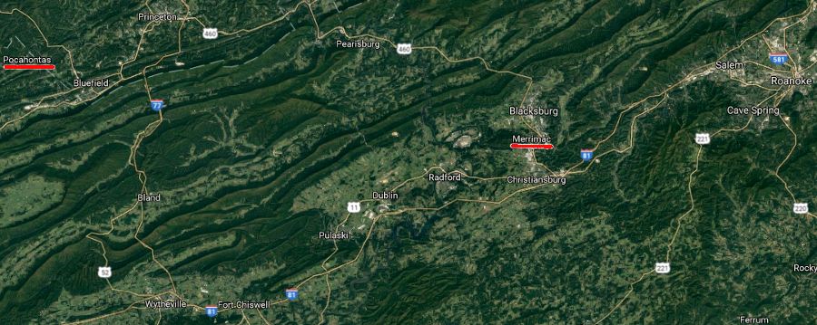
Merrimac Mine in Montgomery County, the supposed source of coal for the CSS Virginia ironclad (formerly a wooden ship known as the USS Merrimac), is just a historic site. It is a stop on the Huckleberry Trail, with old mine sites and buildings marked by interpretive signs.
The Midlothian mines in Chesterfield county are also a park, surrounded by a subdivision. Homeowners there trust that the underground tunnels have already collapsed, and there will be no additional land subsidence due to the old coal mine workings.
Merrimac Mine suuposedly supplied the CSS Virginia in 1862, but the major coal field developed later (in the 1880's) at Pocahontas
Source: Google Maps
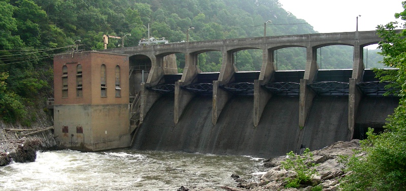
Embrey Dam (energy production does not always have a higher priority than fish...)
In the early 1800's, dams on the Fall Line were built to harness the waterpower for Virginia's mills and factories. Richmond became a major exporter of flour, after grinding the wheat with the energy of falling water. Complex systems of pulleys and cables stretched through multi-storied buildings to transfer the mechanical energy from the river to the millstones for grain, saws for lumber, and other equipment. Five different major dams were built on the James River in Richmond, as the water dropped 100 feet in its 7-mile journey through the Fall "Zone."
One price for economic progress in the 19th and 20th centuries was the sacrifice of fish habitat. To mitigate the impacts of development on the fish populations and the natural ecology of the Chesapeake tributaries in Virginia, fishways have been opened to allow fish to swim around the dams.
Sediments that had accumulated behind Embrey Dam were released when the dam was removed. Because there was little industry in the Rappahannock River watershed upstream of the dam, there were few chemical contaminants (such as PCB's) in those sediments. Biggest enironmental impact of mobilizing the trapped sediments: fish breeding habitat downstream was smothered in silt for several years.
City of Radford has a 1-megawatt hydropower plant on the Little River
Dams that generate renewable hydropower also create adverse environmental impacts. No form of electrical power generation is perfect.
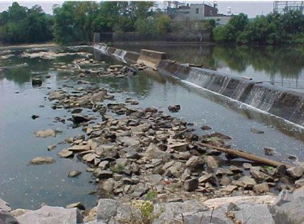
Sediment trapped behind old dams, such as the Power Dam on Pigg River, will be released whenever dams are removed. Sediments spread out on river bottoms, altering habitat and blocking reproduction of some species of fish.
Natural storms will carry sediments downstream, gradually spreading it out (the old saying that "dilution is the solution to pollution" applies to sediments as well as chemicals in water...) - but natural processes could take decades. It is easy (but not inexpensive) to dredge sediments trapped behind a dam, but far harder to dredge sediments once a dam is removed and everything spreads out downstream.
The City of Danville removed Brantley Dam from the Dan River in 2011
Brantley Dam was a "power dam" even though no hydropower was generated there. The dam created a reservoir that provided cooling water for a coal-fired power plant.
When the Brantley Steam Plant was closed, the dam was not recognized as a problem that had to be removed - until a child was trapped and drowned in 2010.
There were 5 low-head dams in Danville. Since 1965, every one of the four drownings at a dam had occurred at Brantley Dam.
hydropower dams (including Claytor, Phillpott, and Smith Mountain) require both topographic relief and adequate water supply
Source: ESRI, ArcGIS Online
Some of the water that flows through the generators at Smith Mountain dam is recycled. The water is pumped back upstream at night from Leesville Lake, and then put though the Smith Mountain dam generators during times of peak power demand (usually morning before work and dinnertime in the evening. Smith Mountain Lake is equivalent to a battery in a flashlight, storing power for use when it is needed.
Pumped storage projects consume more electricity when pumping water upstream than they generate with downstream flow, but the hydropower can be turned on/off on short notice. The utility that generates power at Smith Mountain Lake, American Electric Power (AEP), had an alternative to building Smith Mountain Lake in the 1960's. AEP could have built an additional coal-fired power plant to generate "peak power" - but then the coal-fired plant would sit idle for most of the day and all night, when there was less demand for electricity. It was cheaper to use AEP's other coal-fired plants working steadily through the night, transmitting the excess nightime power to Leesville Lake to pump the water back upstream into Smith Mountain Lake.
Did a government agency or a private company block the Roanoke River and create Smith Mountain Lake?
Should private companies be allowed to dam public rivers?
Should for-profit corporations pay a fee, perhaps a percentage of their profits, for the right to transform public rivers?
Megawatthours of electricity generated in Virginia by different sources in 2012
(Note that "pumped storage" was negative; that source consumed more electricity than it generated)
American Electric Power built a pumped storage project at Smith Mountain Lake, so the utility could generate "peak power." Dominon Power built its pumped storage project on Back Creek and Little Back Creek in Bath County, so it too could generate a surge of electricity for morning/evening peak demand periods.
Both pumped storage projects generate electricity, but require even more electricity to pump the water back uphill to generate power over and over whe needed. The utilities do not have the option of telling customers "Sorry, no power until 8:00pm..." The utilities could expand other power plants to supply electricity to meet peak demand - but running "baseload" plants at less-than-full-power for most of the day would be more expensive than building pumped storage plants that are needed for just brief periods, twice a day.
There is a state park on Smith Mountain Lake, but no park on the upper reservoir at Bath Mountain. Why not?
Remember the two-foot power pool at Smith Mountain Lake - when the power plant is operating, the level of Smith Mountain Lake drops just two feet as water drains through the dam into Leesville Lake.
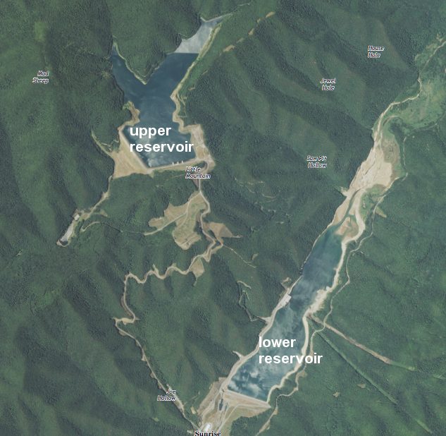
When the upper reservoir at the Bath County Pumped Storage Station is drained to generate power, water levels in that upper reservoir can drop 105 feet while water levels in the lower reservoir can rise 60 feet.
Hmmm... would you spend state money to locate a state park with a marina and swimming area at the Bath County Pumped Storage Station, just like at Smith Mountain Lake?
upper and lower reservoirs at Bath County Pumped Storage Station
Source: US Geological Survey (USGS), Sunrise 7.5x7.5 topographic quad (2013, Revision 1)
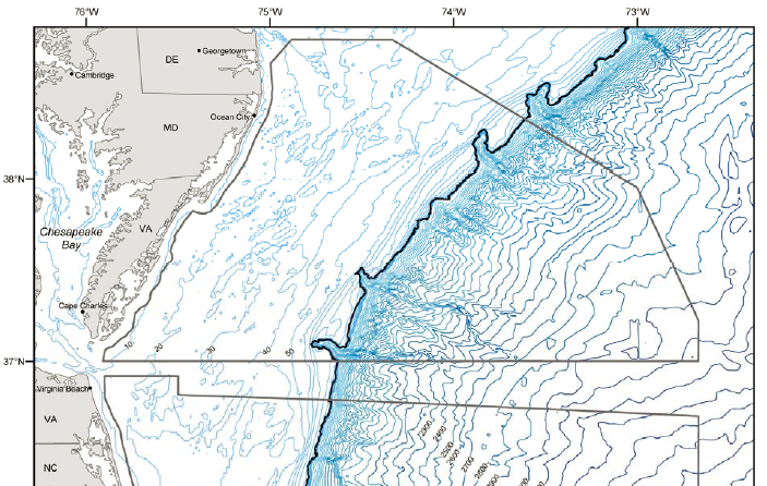
The state of Virginia could offer oil and gas leases within the Chesapeake Bay or within 3 miles of the shoreline, but the energy resources are currently thought to be further offshore in the area controlled exclusively by the Federal government.
Much of the offshore area is used by the military for training (Virginia Capes Operating Area). Some is included in the Wallops Island protection zone, in case there are problems with rocket launches. Some of the area is dedicated as a transportation lane for ships sailing to/from Hampton Roads... but there is still plenty of offshore acreage thought by both the state and Federal government to be suitable for leasing for oil and gas drilling.
Governor McDonnell was "thrilled" when the Obama Administration proposed Outer Continental Shelf (OCS) Lease Sale 220 off the coast of Virginia in March, 2010. The governor wanted to make Virginia the "energy capital of the East Coast."1
In April of 2010, the Deepwater Horizon well blew out and polluted the Gulf of Mexico. In April 2010, the Obama Administration cancelled Lease Sale 220.
Both President Obama and Governor McAuliffe advocated an "all of the above" strategy for energy. Odds are good that under President Trump or a later president, the OCS will be leased. There are hydrocarbons in the offshore sediments, but there is no guarantee that oil/gas will be discovered in quantities large enough to justify commercial development.
Before Africa and North America collided, erosion created sediment in the deep water of the Iapetus Ocean. Organic material in those sediments survived, in the absence of oxygen in the deep water. After the sediments were buried, heat and pressure converted the organic material into natural gas.
The natural gas is trapped in sedimentary layers. There is no natural gas to be extracted from igneous rocks in the Blue Ridge or metamorphic rocks in the Piedmont. The gas comes from decaying animal and plant parts. Even if there was some organic material where igneous and metamorphic rocks formed, it would have been incinerated by the heat and converted into carbon dioxide (CO2) rather than methane (CH4).
80% of Virginia's natural gas comes from coalbed methane wells.
Liquids that condense in natural gas wells are described as "oil," so a natural gas well can also produce oil that is kept in a tank at the site of the well and collected intermittently by tanker trucks
Today, natural gas is being extracted from the sedimentary layer known as the Marcellus Shale by horizontal drilling and fracking. Drillers can curve the path of their drill underground to place long stretches of pipe within horizontal sedimentary layers, then inject water deep underground to fracture ("frack") the rock.
In the old days, only a short piece of a vertical well intersected the payzone with gas. Now drillers can make extensive horizontal paths, with cracks throughout the bedrock. That allows large volumes of natural gas trapped in the 400-million year old sediments to flow to the well.
There's nothing new about the gas to justify the new boom in drilling. The gas is maybe 100 million years old. It's the new drilling and fracking technology that has made the difference, making it economical to develop natural gas fields in sedimentary rocks.
Injected water is extracted from underground after fracking the bedrock. The "produced waters" come back to the surface with dissolved salts, chemicals and gas, and must be treated before disposal. Inadequate treatment and inappropriate disposal has polluted surface waters, creating hostility to the fracking process even among environmentally-oriented groups that want more use of natural gas to replace "dirty coal." Produced waters can be injected deep underground, but those fluids are lubricating deep rock layers and triggering earthquakes in Oklahoma now.
The Board of County Supervisors that resisted approving a Special Use Permit (SUP) consisted of 4 Republicans and 1 Democrat. Local land use decisions are often decided on considerations other than partisan politics.
Note (on p.2) how much money Carrizo Oil and Gas had to set aside, just in case "chemicals used by Carrizo somehow contaminated the groundwater that area farmers rely on..."
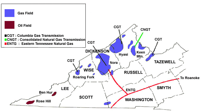
Most of the Marcellus Shale drilling is occurring in Pennsylvania, New York, and Ohio. Virginia has some areas with the gas-rich bedrock, but the percentage of gas in the rock is lower in Virginia - so the political debate over fracking is most intense now in Pennsylvania and New York.
The George Washington National Forest (located in Virginia) has completing a new management plan. An early draft proposed to allow vertical wells, but block horizontal drilling. The final version revised that approach and allowed horizntal drilling, but reduced amount of land available for leasing from 995,000 acres to 10,000 acres. In addition, limited access to water for fracking and local government zoning limits on drilling may block development of most of the Marcellus Shale resource in Virginia.
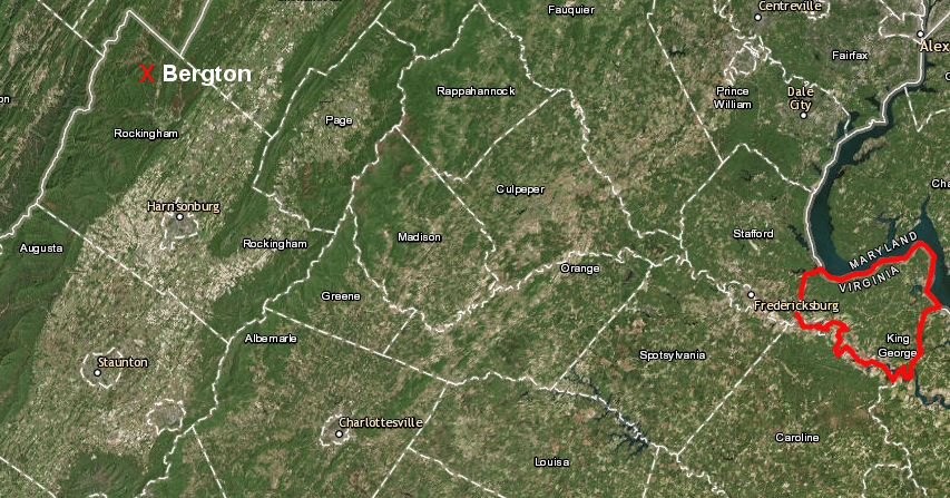
Rockingham County blocked fracking in the Marcellus Shale at Bergton, setting an example for King George County supervisors in the Triassic Basin
Source: ESRI, ArcGIS Online
When you crank up the barbecue and turn the valve on the propane tank, or light the burner on the stove - think that natural gas was produced in Virginia, imported from overseas, or piped in from Pennsylvania/Louisiana?
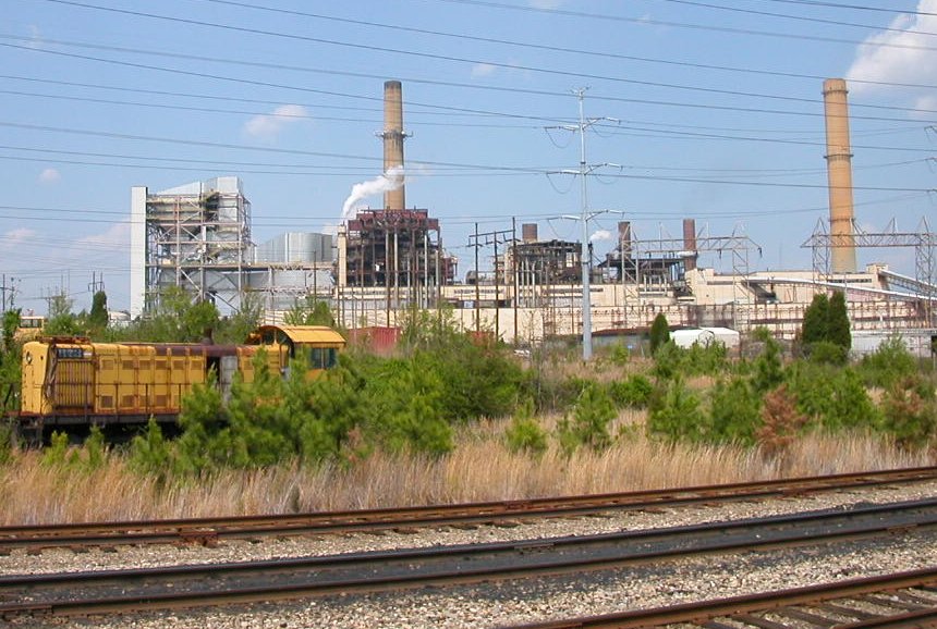
The new demand for natural gas is drived by the electric utilities. Dominion Virginia Power will build a new $1.3 billion natural gas-fired electrical generating station in Brunswick County. The new natural gas-fueled power plant will replace the Chesapeake Energy Center and Yorktown Power Station, both of which used coal to generate electricity.
Natural gas prices are predicted to decline as coal prices increase over the next two decades. "Fracking" will increase the supply of gas, lowering the cost. Extracting coal from deeper and deeper mines will not get cheaper.
President Trump and the new Congress elected in 2016 could provide an expensive government subsidy to make coal cheaper, but Federal officials who take office after a future election could change the rules again. Utilities know that officials elected in 2016 can change the Clean Power Plan and reduce environmental standards, but utilities are expected to choose the fuel whose costs are expected to be lowest over the 20-40 year lifespan of a new power plant that generates electricity.
geothermal energy potential in the United States
(In Virginia, individual houses can use geothermal systems to pump 56-degree groundwater to the surface, to heat/cool a house.
However, underground temperatures in Virginia are too cool near the surface for a utility company to generate electricity from geothermal energy.)
Source: US Energy Information Administration Geothermal Explained: Where Geothermal Energy Is Found
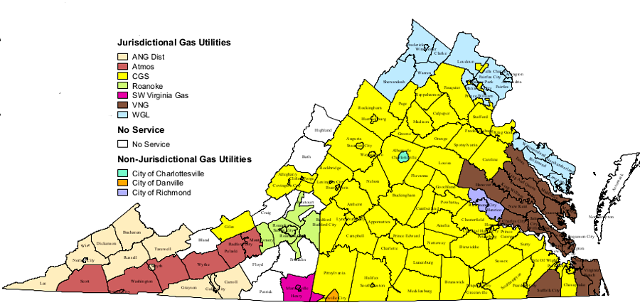
the State Corporation Commission gives natural gas suppliers in Virginia a monopoly to service specific areas, avoiding the cost to build duplicate pipelines to homes
Source: State Corporation Commission
Since the first Arab oil embargo in 1973 created an energy crisis, the US Congress and various presidents have agreed that the United States should be energy independent and not rely upon imports from other countries.
Virginia is not an energy-independent state today because it is less expensive to import refined petroleum products through the Colonial/Plantation pipelines, natural gas through the Transco/Spectra/Columbia/Dominion pipelines, and electricity through high-voltage powerlines. Most of those imports come from other states, though some refined petroleum products are brought by ship from refineries on Caribbean islands. New pipelines to bring more natural gas, such as the Atlantic Coast Pipeline, are in the planning stages now.
Should Virginia try to become energy-independent from the other states? Should Virginia reduce its need to import energy, and find a way to balance the demand for energy within the state with the supply of energy within the state? What is your #1 reason for saying yes or no?
If the General Assembly and governor decided that Virginia should reduce its energy imports, the existing "rules of the game" would have to change. Some state/Federal program(s) would be required to alter current economics. Would your top priority be some sort of program to:
reduce the total amount of energy required through conservation?
expand mining in the abundant coal fields on the Appalachian Plateau?
develop the speculative natural gas resources buried under the sediments in the Taylorsville Basin and on the Outer Continental Shelf?
incentivize new wind and solar farms?
For the last two governors, the answer has been "all of the above" - and they both governors ducked the question of whether the Coles Hill uranium deposit should be mined. The "all of the above" approach minimizes the potential of a political candidate losing some votes, but does not set any priorities.
You don't have to fake it to get votes - so which of those four choices above would be your highest priority?
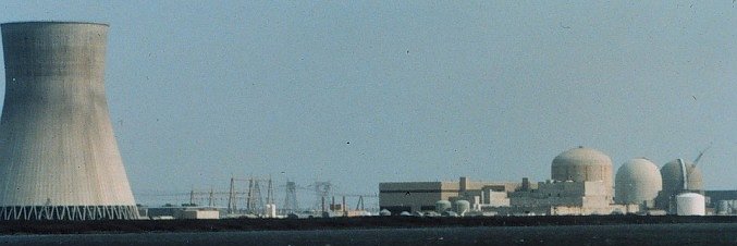
cooling tower at nuclear power plant (on left), containment buildings for reactors (on right)
Source: NOAA Photo Library
Web Exercise:
Visit the Dominion Resources (a.k.a Virginia Power, and formerly known as VEPCO) site for Nuclear Power Stations. Check out the online information about one of the two Virginia plants at North Anna. (There are two reactors at North Anna and two more at Surry, so there are four commercial nuclear reactors at two nnuclear plants in Virginia - not counting the Navy's nuclear-powered aircraft carriers and submarines in Hampton Roads).
Examine the Protective Action Zones and Evacuation Assembly Centers links for Surry to determine if there are plans to evacuate the tourists from Colonial Willamsburg in case of a nuclear accident at that plant. If you were a tourist in Zone 21 (City of Williamsburg), would you flee on Interstate 64 east to Hampton?
In Williamsburg, the wind direction is most often from west to east, blowing towards the Atlantic Ocean...
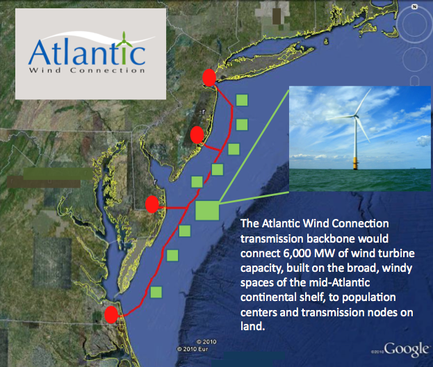
offshore wind is the most expensive option for renewable energy, but Google has proposed an underwater power transmission line
Source: Google, The wind cries transmission
Site Visit:
Follow a power line that comes to your site. If you have a house at your site, you own the wiring; it is your headache if there is an electrical problem associated with the inside wiring. Outside your house, the power company is responsible for the wires. The power company pays the crews to reconnect the power grid after a storm, to get electricity from the nearest pole to the meter at your house.
- is the power line to your house buried underground, between your house and the power line on the street?
- if so, can you trace the wire underground, so you will never dig into it if you plant a new tree?
- if not buried... then why not? How much do you think it would cost to get an overhead power line buried now, just like they are in the newest subdivisions?
- if the power company moves their power poles, do you think they need to get a new easement from you in order to authorize putting their wire over a different piece of your land? (Your home may be your castle, but is your yard exclusively your property?)
- find the nearest transformer on a pole. (It is more efficient to transmit electricity at high voltage, but houses operate on low-voltage 110-volt and 220-volt circuits. In most areas, power is distributed at 12,000 volts, and a transformer near your house converts the electricity to 120-volt circuits.) To get to your house, does the 120-volt power line stretch more than one city block?
- if you live in a rural area, is the transformer near your house... or does the low-power circuit stretch all the way from a transformer out on the public road to your house? (Think the utility company is willing to accept some inefficiency in transmission for "the last mile," in order to have easy public access to the transformer for maintenance and repair?)
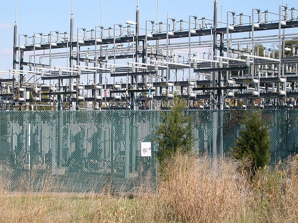
- trace the power line from the transformer to the nearest substation, where voltage is transformed even higher than 12,000 volts. How close is your electricity substation?
- find the nearest power generating station to your house? What fuels your nearest source of electricity? Is it a natural gas facility, operating only intermittently to provide "peak power"?
- if you have solar panels, what percentage of your energy comes from the centralized power grid vs. your own decentralized generation?
Northern Virginia Electrical Cooperative substation (Route 29 west of Centreville)


