Assignments for Week 5: The Initial Peopling of Virginia
Wherever you live in Virginia today, there is an excellent chance that Native Americans walked across your yard in the last 15,000 or so years. Bands of hunters and gatherers examined every hill and valley, seeking food. If there is a scenic overlook nearby, Native Americans probably stopped to enjoy the view. While "doing lunch," they may have reworked some stone points/knives and left flakes of stone on the ground as ancient litter.
The story of Native Americans in Virginia is the least-discussed, and most-misunderstood, aspect of population geography in Virginia. The fundamental misunderstanding is that there are no Virginia Indians left from the days of Pocahontas; somehow, they all just disappeared in a magical "poof." The backstory: to avoid social conflicts and cultural/economic discrimination, Virginia Indians often chose to "live off the grid" and minimize interaction with whites during the 1800's and much of the 1900's. They were always here, but not always visible.
Lots of links below, but relax: nearly all items are short.
When the Europeans arrived in Virginia in the 1500's, the first Virginians had no written language. The Europeans documented what they found, but those reports reflected the biased views of the explorers, traders, and colonists.
We also know about the first Virginians because they left material other than written documents. The changes in the styles of pottery and stone points used for spearpoints, knives, sewing needles, scrapers, and arrowheads tell us how societies changed over perhaps 15,000 years of human occupation of Virginia before the Spanish tried to create a colony at Ajacan (near modern-day Yorktown) in 1570, and the English finally succeeded at Jamestown in 1607.
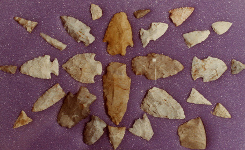
The larger points displayed in exhibit cases might fit on a spear, but next time you see "arrowheads" on display, imagine how far an arrow would fly with a heavy attachment at one end. Hunters were savvy and their families were hungry, so most points were crafted to be functional tools. Tiny stone flakes recovered by archeologists at campsites occupied for just one night perhaps 1,500 years ago show that points were constantly sharpened; stone tools grew dull very quickly.
Tiny "bird points," the size of your little fingernail and not showy enough to put in the exhibit case, were put on the killing end of most arrows.
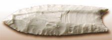
Cactus Hill is important because it indicates Virginia was settled by humans before the Clovis culture, which had a distinctively-shaped Clovis point. That culture developed 13,000 years ago, about the time the Bering Land Bridge was exposed.
How could anyone get to North America sooner, if ice blocked the Bering Land Bridge? The answer is still not clear, but Cactus Hill was key to showing that it happened. Someone was camping along the Nottoway River, sheltered by the sand dunes and feeding in the freshwater marsh, 5,000 or more years before the Clovis point became popular.
The Cactus Hill site is identified by the Virginia Department of Historic Resources and the Archeological Society of Virgnia as 44SX202. That is the code for the 202nd site recorded in Sussex County (SX), in Virginia (state number 44 in the numbering scheme of archeologists).
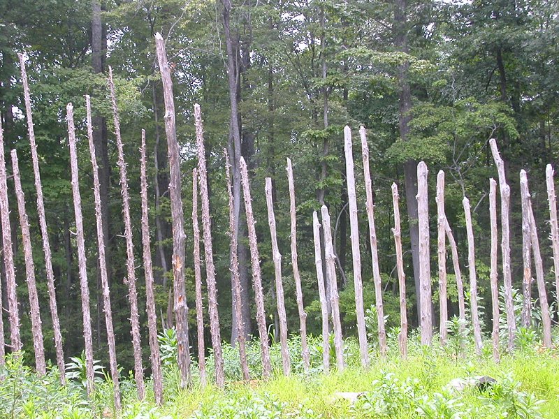
Think the First Virginians lived in peace and harmony with nature and each other? If so, how would you explain the effort invested in constructing palisade walls around Native American towns, when the primitive tools to cut trees were bone, stone, and fire and there were no wheeled vehicles to haul the logs to the town?
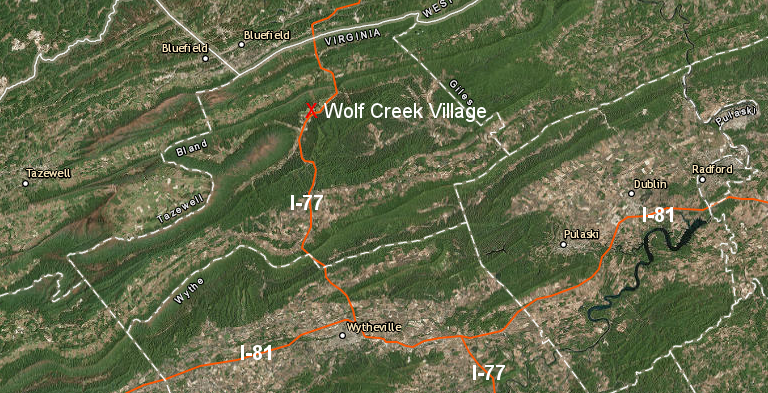
At the Wolf Creek site occupied between 1490-1530AD, the 100 or so residents built a wooden wall for protection.
Read the very short history and this excerpt from the Brown Johnston Archeology Report:
PALISADE (Feature 31) This was a irregular circle 130' by 140' across, composed or 229 postmolds, enclosing all of the houses and most of the pit features. The individual posts were spaced about one foot apart and were mostly small saplings, usually three or four inches thick. These were set vertically in holes which usually did not exceed a total depth of fifteen inches - twelve inches of topsoil, plus the top three inches of the subsoil. Such positioning and depths indicate that the posts extended out of the ground for about eight to ten feet.
Since the gaps between posts would have permitted a slender person to slip through, it is likely that the spaces were filled with brush, branches, vines, and so on, woven parallel to the ground up to the height desired. This would have made the palisade look like a wicker basket, but it would have stopped an arrow.
It would also have prevented the undetected entry of an enemy seeking to penetrate the town to attack sleeping occupants. The noise made by anyone trying to climb over or through the palisade would have awakened dogs, at least. One weakness of the palisade, though, would have been its flammability. (Any enemy attacking the town would have almost certainly have set fire to the flimsy, dry and combustible palisade as an essential part of his attack. This would have alarmed the occupants, however, and the advantage of surprise would have been lost.
Wolf Creek Village was discovered when I-77 was built
Source: ESRI, ArcGIS Online
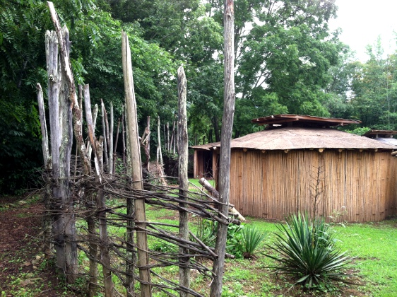
What did the palisades around Virginia's first towns look like? We do not know. Archeologists can map the location of posthole molds of dark soil spots, and that tell us where the posts were located - but not if the posts were wrapped together tighly with vines. Maybe some tribes wove sticks between the posts to create a stronger barrier, while other tribes left the posts unconnected so the occupants could see through the palisade and even escape through it, if needed.
widely-separated poles in the palisade around the reconstructed Totero site at Explore Park near Roanoke show it was designed to slow an attack, not to block all arrows
most of the living history exhibit at Explore Park on the Blue Ridge Parkway near Roanoke is now closed, but at one time interpreters constructed a Native American village based on an understanding of the Totero tribe's lifestyle over 400 years ago.
The modern-day reality of building a house from bark, vines, and saplings, with stone and bone tools, required a great deal of muscle power. Building a palisade in the 1600's would have been exhausting labor. Maybe the town "walls" were composed of a circle of close-but-not-squeezed-tight-together poles. Those would require less work than building wood-intensive barriers equivalent to modern-day back yard fences.
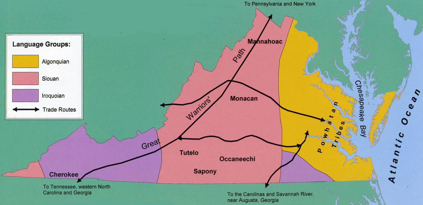
the European colonists who explored Virginia in the 1600's found different territories controlled by different tribes using three major language groups
Source: Virginia Geographic Alliance, "An Atlas of Virginia," American Indians (First Americans) circa 1600
The National Park Service has an "Overview of the Powhatan Chiefdom" that notes:1
In the northern Virginia Coastal Plain, Indians speaking Algonquian dialects related to the Powhatans' engaged in a shifting set of relations with the Powhatans and their paramount chief...
The Monacans and Mannahoacs, probable Siouan speakers referred to collectively as the Monacans in some contexts, resided in the Virginia interior, west of the fall line... Fleeting contacts with English colonists and the brief textual references to these encounters confirm that the early seventeenth-century Monacans lived in settlements lining the Piedmont portion of the James and Rappahannock rivers.
To the south of the Powhatans, Iroquoian-speaking Nottoway and Meherrin Indians' settlements lined the rivers still named for these groups
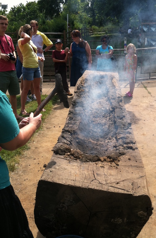
building a canoe with fire, stone scrapers, and mud to protect edges
(2012 Virginia Indian Festival at Riverbend Park, Fairfax County)
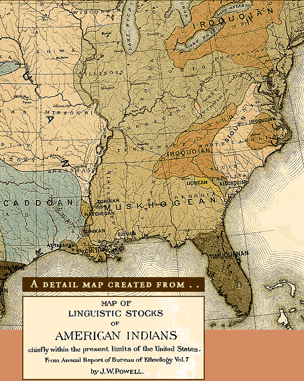
presumed range of linguistic groups at time of European contact
In the Treaty Between Virginia And The Indians, 1677, read Section II (That the said kings and queens and their subjects...) and Section III (That all in agreement with us...). Those short statements were supposed to define property rights between settlers and Native Americans, but clearly were not implemented.
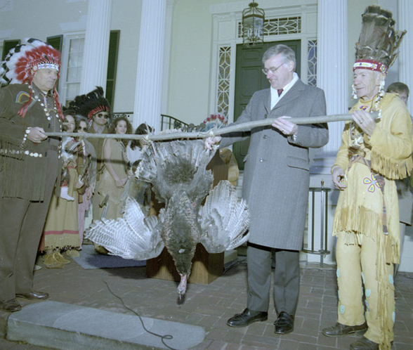
The annual reservation taxes are defined as "three Indian Arrowes" in Section II. Each year near Thanksgiving, watch for the chiefs to give the Governor of Virginia deer and turkeys. The ceremony is designed for media coverage, but the basis for the gift goes back to treaties signed a cebtury before the Federal government was created. That's part of the problem for Virginia tribes - the United States of America was created after the treaties were signed by the colonial government in Virginia, so the Federal government has no history of direct negotiations with established tribes in the state.
Governor Baliles receives payment at Governor's Mansion in Richmond, 1989
Source: Prints & Photographs, Special Collections, Library of Virginia - published online by National Relief Charities blog
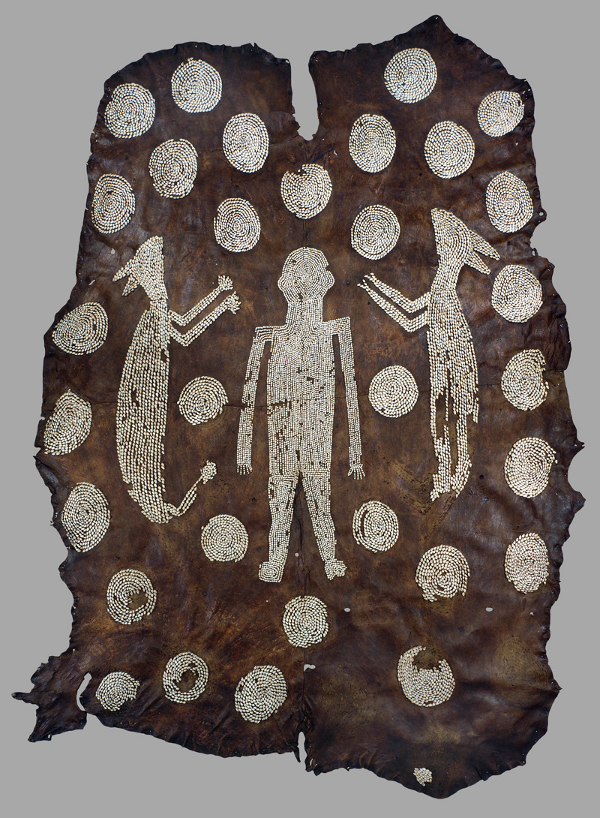
four decorated deerskins may have been a ceremonial cloak for Powhatan
Source: Ashmolean Museum, Powhatan's Mantle
This was a deerskin cloak brought back to England around 1635. Most organic material used by Native Americans in the pre-Contact period, prior to the 16th Century, has decayed to dust. It is rare to have authentic Native American clothing from Virginia, even from the period after the English arrived permanently in 1607.
Think those 4 deerskins were used as clothing to wear, or for a different purpose? The Native Americans in Virginia did not have a system of writing, but could have recorded historic events by other means - such as using deerskin as "parchment."
The Ashmolean Museum reports that Randolph Turner, a well-respected Virginia archeologist and historian of the Contact Period:
...has suggested that the thirty-four roundlets perhaps represented the districts under Powhatans control.
The use of circles to represent human social groups, from the level of villages to entire tribes, is the single most widely shared symbolic feature of southeastern Indian maps... The distribution of roundlets is essentially symmetrical, suggesting that there was no attempt to show the actual geographical distribution of the tributary chiefdoms.
The Virginia Historical Society's exhibit on Invented Scenes for Narratives discusses the Abduction of Pocahontas scene. Do you think the European engraver portrayed the king of the Patawomecks as - well, think he's presented as a devil? What does that tell you about the expectations of the colonists? "Primary sources" include documents written by John Smith and others in the early days of contact between the cultures, but consider the source: we read primary sources from only one side.
For the English, capturing a Native American was no big deal in the 1600's. However, capturing a daughter of a king triggered all the concerns of European royalty for self-preservation. When the English chose to ignore the complexity of Powhatan's paramount chiefdom and just call him a king, Pocahontas became a princess. Captain Samuel Argall's seizure of a princess needed to be justified; otherwise, the safety royal families in Europe could be threatened.
The solution was to convert Pocahontas to Christianity and incorporate her into English culture. Perhaps she was manipulated into abandoning her Algonquian heritage, but it is also possible that she saw the advantages of becoming a person of high status in English culture. In Tsenacomoco, she was just one of many chidren who shared Powhatan as a father - but in Jamestown, she was special...
NOTE: the USGS Geographic Names Information System does not refer to Marlborough as a "point" - according to USGS, it is a "cape" and a "populated place."
watch this Abduction of Pocahontas video from the Virginia Historical Society
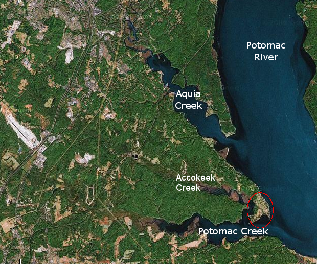
Marlborough Point, where Pocahontas was captured
Source: Google Earth
(This Virginian-Pilot article explains why 6 Virginia tribes requested special legislation, rather than followed the normal administrative process established for requesting Federal recognition)
Since Europeans arrived and brought slaves from Africa, the population of Virginia has included many blended families with genes from multiple sources. Pocahontas married an English colonist (no, not John Smith...), and her mixed-race descendants are still present in Virginia. Escaped slaves had children with Virginia Indians; whites and blacks had offspring - but under a 1924 law, it was official state policy to obscure the continued existence of Virginia Indians.
The conscious, racist, eradicate-Indian campaign was led by Walter Plecker, who denied any distinction between Virginia Indian and "colored" people. In addition to the desire to retain awareness of their familiy heritage, Virginia Indians recognized that in the days of legal segregation based on race, the impact of being classified as "colored" vs. "white" were significant.
Federal recognition of Virginia tribes, allowing access to federal grants and support services, has still not passed through the Executive Branch (Bureau of Indian Affairs) administrative process or through special Congressional legislation. The Federal process requires documentation of a tribe's continued existence, and in Virginia much of that documentation was destroyed in the 1800's and 1900's.
Today, the Pamunkey tribe is the only one that has achieved Federal recognition through the administrative process. In July 2015, the Bureau of Indian Affairs in the US Department of the Interior (the agency responsible for Federal recognition) announced that the Pamunkey's petition had met all the criteria for approval.
The Commonwealth of Virginia has recognized 11 tribes. The last three tribes in Virginia to receive state recognition obtained that status through a law passed by the General Assembly in 2010. The Virginia Council on Indians, which managed the state administrative process, had not endorsed state recognition. The legislative act ignored the negative recommendation, and in response the other eight tribes stopped participating in the Virginia Council on Indians. In 2012, the General Assembly abolished the Virginia Council on Indians.
Federal recognition for Virginia tribes could come through legislation passed by Congress, rather than through the administrative provess managed by the Bureau of Indian Affairs in the Department of the Interior. Such legislation could block any opportunity for Virginia tribes to open gambling casinos, which have become profitable businesses on reservations in other states.
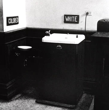
separate-but-equal facilities were clearly not equal, and Virginia Indians resisted efforts to classify them as "colored"
Source: Library of Congress, Civil Rights
Map Exercise:
Using the Library of Congress versions, explore John Smith's original map of Virginia to find modern-day Marlborough Point, where Pocahontas was seized in 1613. The Cheroenhaka/Nottoway tribe, located south of the James River, says John Smith noted their presence. You know where the Nottaway River is located - so use that as a clue to identify what name John Smith first assigned to that tribe.
Site report:
How would you tell the Native American story associated with your site?
As part of that process, consider how do people lived on your site during Paleo-Indian, Archaic, and Woodland periods. How would you have found shelter when it rained or snowed - is there some obvious advantage/disadvantage to your site, compared to places within a few miles?
If you were living there 10,000 years ago, 5,000 years ago, and 500 years ago, how would you have dressed, obtained food, and socialized with others? If you had seen another band of people on a nearby ridge, how would you have indicated you were peaceful and wanted to visit together, rather than interested in fighting? Without TV or Facebook, how would you have entertained yourself - and your family, especially the children? Think there were sports contests of some sort, conducted right at your site?
Also, identify the location nearest to your site that is associated with Native Americans. (One way to check: use the Virginia Tourism Corporation Virginia Is For Lovers website. How is that Native American site highlighted in some way for the public to recognize its historical value, or is it not advertised (providing some "security through obscurity" protection from looters/vandals)?
Now identify the location of the oldest building or archeologic site closest to your home, job site, or area of special interest that is associated with European settlers in the colonial era. Compare the attention dedicated to the two sites:
- how close is a Native American you can identify vs. the colonial site?
- how well advertised is the Native American vs. the colonial site (including highway signs and on the internet)?
- how detailed is the information on each site about the Native American history vs. the colonial history?
- what additional advertising/information would you create for the Native American site nearest you, in order to generate more tourist visits? Be creative; propose an advertising campaign with slogans, how you would "market" the site to specific visitors (local residents? other people living in Virginia? residents of nearby states? international tourists?) and determine the budget you would require to implement the campaign.
Remember looking at a stream in Week 3? Reconsider that site.
Wherever there was water and a marsh nearby, plus some flat alluvial bottomland with relatively rich soil, then Native Americans could have built a town and grown crops. Are there any flat places near your site, where Native Americans might have planted crops? If not, is there any reason for Native Americans to have been at your site, other than "passing though" while hunting or gathering food? What trees or other plants are offering natural foods today at your site?
Native Americans lived near streams and carried all the water they used water by hand; there was no Fairfax Water, Loudoun Water, Virginia-American Water, or other utility company that piped water to the inside their houses. For Native Anericans in a hunting party or village, what vessels do you think they used to carry their drinking and cooking water? (There's a reason they grew squash; it was not always for food.)
The Fairfax County Park Authority uses Geographic Information System (GIS) technology to predict where archeological sites might be located, and focuses field investigations accordingly when examining sites before construction of new bridges, trails, or structures disturbs the soil. The site planned for one abutment of the Clarks Branch bridge at Riverbend Park, upstream from Great Falls National Park, turned out to be an archeological treasure trove.
"[T]he area that is now Riverbend Park was inhabitated continuously from 12,500 years ago all the way until the contact period with the European settlers. American Indian sites have been discovered at Riverbend throughout the floodplain, and on the top of the hills just above the floodplain. The county archeologist Mike Johnson said that Riverbend Park has the richest American Indian history of any site in Fairfax County."2
Archeological sites include places associated with time periods after initial European contact with Native Americans, including colonial homesites and Civil War battlefields - and Native American sites occupied long after initial contact with Europeans. When the English arrived, the Native Americans did not just disappear in a flash to make way for civilization. In fact, the first Virginians are still here, though their story is rarely told except at Thanksgiving.
"More than 3,000 Fairfax County archaeological sites have been registered with the Virginia Department of Historic Resources that serves as the State Historic Preservation Office for the Commonwealth of Virginia. In addition, 1,000 more sites have been recorded, including archaeological sites, cemeteries and architectural resources that need additional survey. More than 870 sites have been identified on Fairfax County parkland; however, only a small percentage of archaeological sites have been subject to a comprehensive survey."3
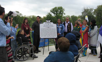
dedication of highway marker for The Great Indian (Wagon) Road
Source: Virginia Department of Historic Resources, Virginia Historical Highway Markers