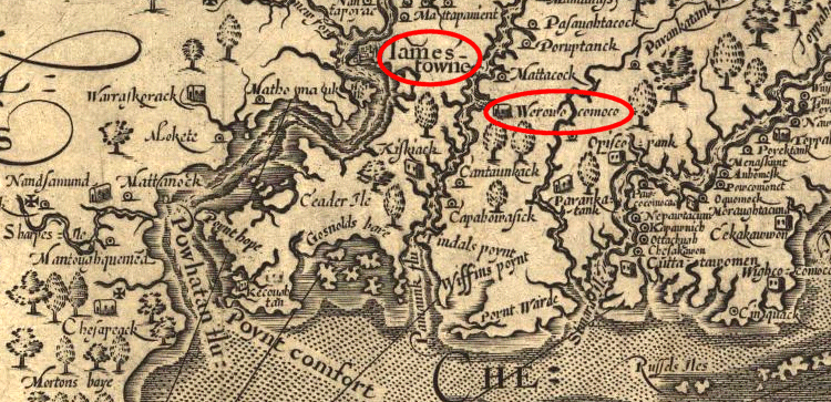
The National Park Service now owns Werowocomoco, which was an Algonquian spiritual center and the site of Powhatan's capital. The 260 acres will probably be open to the public in sometime in late 2018 or, more likely in 2019.
Until now, the Captain John Smith Chesapeake National Historic Trail has been a line on a map, plus brochures and existing historic sites managed by partners. Now the National Park Service has a chunk of land, and it's quite appropriate for this particular unit of the park system. John Smith was seized while exploring in January 1608, paraded to various sites (including the town of the Rappahannocks, who declared Smith was too short to be the English ship captain who killed their chief in 1603) and brought to meet Powhatan at Werowocomoco.
Smith later claimed that Pocahontas saved him from having his head bashed in, at Werowocomoco. That story may be associated with a ritual in which Smith was "adopted" by Powhatan - or it could be pure fiction, invented by Smith and he needed some buzz to sell books. He did not tell the tale until after Pocahontas and Powhatan had both died, and no one could contradict him.
Werowocomoco was the capital of Tsenacommacah in 1607
Source: Library of Congress, Virginia (John Smith, 1624)
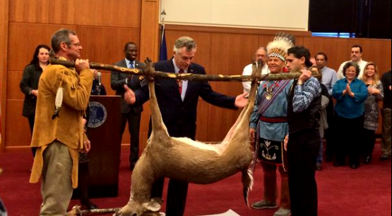
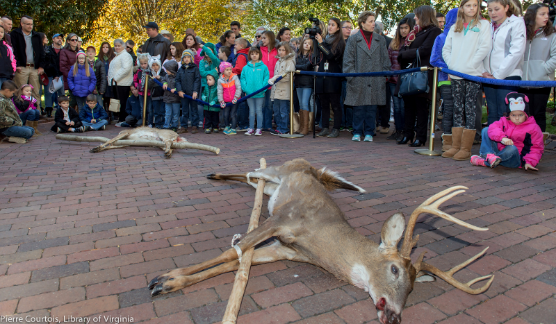
Native American tribes presented Governor McAuliffe with the annual tribute. The traditional tax tribute ceremony was the 339th time the tribes had complied with the Treaty of Middle Plantation, signed in 1677.
Technically, the treaty requires a different tax:1
That thereupon the said Indian Kings and Queens and their Subjects, shall hold their Lands, and have the same Confirmed to them and their Posterity, by Patent under the Seal of this His Majesties Colony, without any Fee, Gratuity or Reward for the same, in such sort, and in as free and firm manner as others His Majesties Subjects have and enjoy their Lands and Possessions, paying yearly for and in lieu of a Quit Rent, or Acknowledgment for the same, onely Three Indian Arrows.
The sovereign status of the tribes within the state of Virginia creates a confusing mix of government authorities, and the state's compliance with the treaty has varied at times, but the Governor's news release typically claims the ceremony is the oldest continuing nation-to-nation ceremony in the United States.2
Pamunkey and Mattaponi leaders provided two deer to the governor in 2016 - and he joked with the chiefs about which deer was larger
Source: Governor of Virginia, Flickr pool
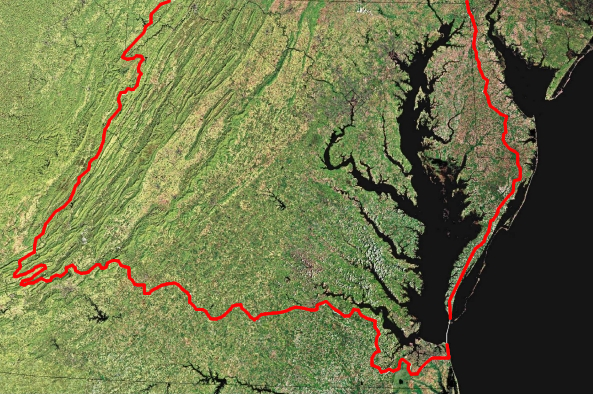
This is a "capstone" week, incorporating material from previous classes to understand one region of Virginia, the Chesapeake Bay. Terms and topics related to the Chesapeake Bay from previous classes include:
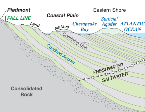
Bedrock dips underneath the Coastal Plain, between Fall Line and Atlantic Ocean. Are the sediments above the "basement rock" in Virginia Beach thicker than the layers of sediments at Williamsburg?
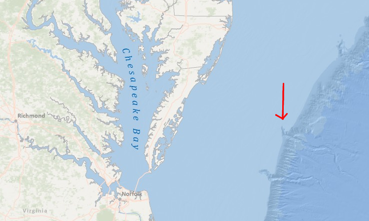
Washington Canyon (red arrow) is one clue that the mouth of the Susquehanna River was located north of its current exit at the southern edge of the Chesapeake Bay
Source: NOAA National Geophysical Data Center, Multibeam Bathymetric Center
"Fresh water" has less than 0.5 parts per thousand (ppt) of salt. "Brackish water" varies in salinity, between 0.5-25 parts per thousand. "Salt water" in the ocean water today has 35 parts per thousand salt.
There is hypersaline water (<35ppt salt) trapped in the bolide's crater. It may have been generated by flash evaporation immediately after the bolide's impact, but it may be even older, trapped in the sediments that formed during the Early Cretaceous geologic period 145-100 million years ago (when dinosaurs were leaving their tracks across Virginia).
Average ocean salinity in the Early Cretaceous was 70 parts per thousand. Modern sea water is 35 parts per thousand. Virginia's climate has changed, ocean salinity has changed, and the species growing/wandering around the state have changed over geologic time.3
The ecological challenges created by the ongoing sea level rise in the Chesapeake Bay is not the fact that things are changing; that's old news. The problem is that the changes are predicted to occur so fast. Existing wetlands, oyster bars, and barrier islands may be drowned faster than they are created by natural processes, eliminating some features rather than simply pushing everything "up" as the water rises.
The Chesapeake Bay is geologically a very young feature on the landscape. If you could hop in a time machine and go back to the time when the first humans arrived in Virginia... there was no Chesapeake Bay.
A bolide (comet/asteroid) struck offshore of the North American coastline, 35 million years ago during the Eocene epoch. The site of the bolide impact was covered with water at the time of impact; sea level was higher and the shoreline was near modern I-95. To the west of the impact crater, as well as to the east, there was just ocean. There was no Eastern Shore, and there was no Chesapeake Bay when the bolide arrived.
About 10,000 years ago, rising sea levels flooded the Outer Continental Shelf and the edge of the Atlantic Ocean moved east, reaching the current location of the Chesapeake Bay Bridge-Tunnel. As the ice continued to melt, the height of "sea level" rose. The channels of the James, Susquehanna, and other rivers were drowned. The Chesapeake Bay as we know it is about 3,000 years old; it is not 35 million years old.
The bolide blasted through the salt water, and drilled down far enough for its energy to crack the earth 7 miles underground.
Since the impact, the local topography has changed substantially. The Eastern Shore has grown. Sediments washed down the Hudson/Susquehanna rivers, and during times of low sea level ocean currents piled the sediments in front of the Susquehanna River. When climate changed and sea levels rose, the mouth of the Susquehanna River migrated south and the Eastern Shore got longer.
Today, the site of the bolide impact is buried under an additional 1,500 feet of sediments brought south by river/ocean currents. The top layers of the current Coastal Plain of Virginia, east of I-95, was deposited in the last 35 million years when sea levels were higher and the Atlantic Ocean shoreline paralleled I-95.
The bolide created a massive, one-time wave of water that swept across the eastern edge of the continent and may have reached the Blue Ridge - but you can't walk on the surface that was swept by that wave. Over the last 35 million years, the surface of the Piedmont has eroded thousands of feet lower, while the surface of the Coastal Plain has been elevated and extended eastwards by deposition. When you walk around at Williamsburg, you are walking mostly on sediments deposited in the last 35 million years.
Just 18,000 years ago, the Wisconsin stage of the last ice age was ending. Sea levels were roughly 300 feet lower, and the Atlantic Ocean coastline was 30-40 miles to the east. That means the Coastal Plain of Virginia was 30-40 miles wider, extending to the edge of today's Continental Shelf, 18,000 years ago. The Susquehanna River flowed through a standard river channel with dry land on either side, and flowed as a freshwater stream for an additional 30-40 miles before reaching the ocean.
long after the bolide arrived, the Susquehanna River brought sediments downstream, and when sea levels rose again the river carved new channels further south (in black); the James and York river channels may have intersected the subsiding crater before the Susquehanna River arrived that far south
Source: US Geological Survey (USGS), The Chesapeake Bay Bolide: Modern Consequences of an Ancient Cataclysm
After the bolide excavated a deep crater and cracked the bedrock, material blasted out of the ground quickly re-filled the crater, creating a jumbled mass of broken rock called the Exmore breccia. Those sediments in the "bowl" of the crater have kept compacting slowly for the last 35 million years. Even today, the a geologic formation called the Exmore breccia has been subsiding slightly faster than surrounding sediments outside the crater, creating a long-lasting topographic depression. Nearby river channels have been affected by the depression:4
Probably because of its rapid deposition, the Exmore breccia compacted more rapidly than the surrounding, older, strata with the result that its upper surface has dropped or sagged through time.
As you know, water flows downhill. 35 million years later, when the Susquehanna River finally reached the crater loooooooooong after the bolide had impacted, the river cut its channel through the topographic depression. The time when the James River and York River channels intercepted the crater's depression is less clear; the obvious bend of those two rivers where they cross the crater boundary suggest their channels may have been shaped by the crater before the Susquehanna River arrived.
Note that the James, York, and Susquehanna rivers did not flow in their current channels for the last 35 million years. Other rivers brought down the 1,500 feet of sediments that have buried the bolide crater. The rivers we see on the landscape today may be much, much younger than the rivers that created the current Coastal Plain.
In particular, the mouth of the Susquehanna River used to be far north of its current location. The river mouth was pushed south by sediments deposited along the Atlantic Ocean shoreline. That river mouth was filled in with sediments that accumulated when sea levels were high. When sea level dropped, the Susquehanna River carved a new channel further south, bypassing the barrier - and thus extending the peninsula of the Eastern Shore. The location of the Susquehanna River's latest drowned mouth (at the tip of the Eastern Shore today) has been shaped by the bolide's effect on local topography, but only when the Susquehanna River was pushed far south of its old mouth did it encounter the crater.
The Chesapeake Bay itself is not a bowl excavated in one dramatic event by a meteor/comet strike. Shifting sediments and a migrating mouth of the Susquehanna River, followed by sea level rise over the last 18,000 years since the end of the last cold period, should get credit for the creation of the bay - not the bolide.
the channels of the York and James rivers bend when they intersect the crater
Source: ESRI, ArcGIS Online
Maryland allows casino gambling, while Virginia does not - not even on the Pamunkey Reservation.
Where would you dock a boat on the shoreline of the Potomac River to atract business from Virginia customers, without making them drive across the Woodrow Wilson Bridge?
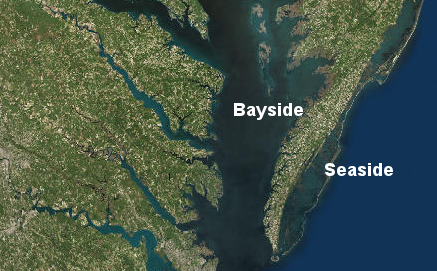
on the Eastern Shore, directions may be given in terms of seaside vs. bayside rather than east vs. west
Source: ESRI, ArcGIS Online
Aquaculture entrepreneurs who start an oyster-growing project need to control access to the oysters that will be planted on the bottom or raised in cages. Who issues the lease for submerged lands in the Chesapeake Bay?
"Bayside" on the Eastern Shore is the western edge of the peninsula, which is the eastern side of the bay. On the Eastern Shore, "Seaside" beds will be on the Atlantic Ocean side, where salt concentrations are higher. The change in merroir means the oysters from Seaside taste differently from oysters raise on Bayside - but does a Federal rather than a state agency issue permits on Seaside?
the Federal government controls leasing for wind turbines and oil/gas on the OCS
Virginia and Maryland own the bottom of the Chesapeake Bay, Those two states would issue leases for use of submerged lands in the Chesapeake Bay for wind turbines and drilling for oil/gas wells.
President Trump might revise the plans for leasing the Outer Continental Shelf that is more than three miles offshore, but the Federal government can't open the Chesapeake Bay to leasing.
In 1781, the French fleet sailed into the Chesapeake Bay and blocked reinforcements from New York from reaching Lord Cornwallis's army under siege at Yorktown. The French fleet controlled the entrance into the bay and acted as a stopper, blocking the "neck" of the bottle between Cape Charles/Cape Henry.
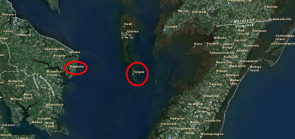
In 1813-15, the British seized Tangier Isand and used it as their base for the Chesapeake Campaign. On the island, escaped American slaves were trained as British soldiers. The British created a regiment of Colonial Marines, like Lord Dunmore's Ethiopian Regiment created from escaped/captured slaves during the Revlutionary War.
After burning Washington and looting Alexandria, the British returned to Tangier Island before sailing off to attack Baltimore. Before leaving the island to attack Fort McHenry, the troops listened to Joshua Thomas, the Methodist "Parson of the Islands," preach a service predicting the British attack on Baltimore would fail. Francis Scott Key saw the Americans hold out despite "the rockets red glare, the bombs bursting in air," as predicted by the Tangier Islander, and wrote what is now the National Anthem several days later.
Fort Albion, the British base on Tangier Island in 1814, is now 10' underwater due to sea level rise.5
why does the Chesapeake Bay Bridge-Tunnel have two tunnels?
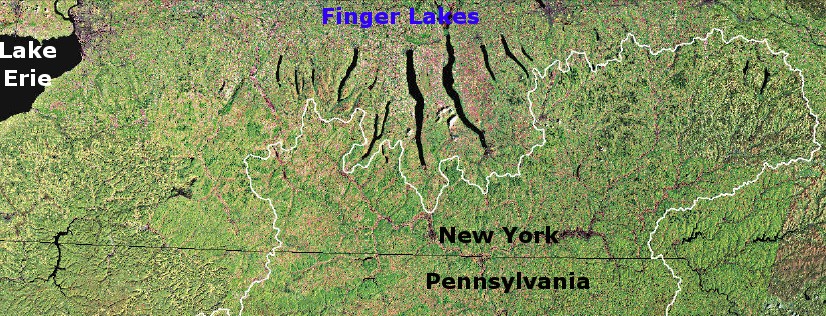
Chesapeake Bay watershed extends north of the Pennsylvania-New York border, up to the edge of the Finger Lakes region
Source: US Geological Survey, Poster Map of the Chesapeake Bay Watershed
Settlement stayed primarily east of the Fall Line for many decades after Jamestown. Richmond was not chartered until the 1730's, and Alexandria was not chartered for almost 20 more years.
Sailing out of Baltimore requires extra time to go down the bay to the ocean, but customers from Pennsylvania and Ohio can save several hours of driving compared to a cruise from Norfolk.
Maryland, Virginia, and EPA completed a Use Attainability Analysis and redefined the designated uses for the Chesapeake Bay and its tidal tributaries in 2003.
the impact of pollution reaching the Chesapeake Bay from wastewater and agricultural runoff is declining, but stormwater impacts are still increasing as population grows and more land in the watershed is converted from forests/fields to roads/subdivisions
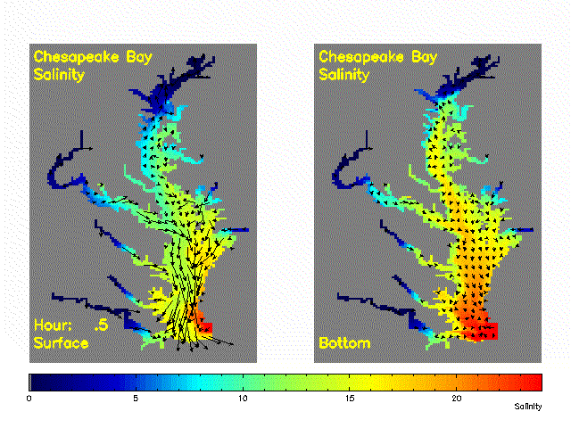
On the surface within the bay, wind and currents can easily transport slugs of salt and fresh water, but frsh water typically floats on the surface while the water on the bottom will be saltier. Daily tides move wedges of fresh/salt water up and down the rivers. Fish can swim around to find their preferred conditions, but after hurricanes the massive slugs of freshwater runoff can reduce salinity far downstream and kill oysters trapped in one spot.
The water in the bay changes seasonally. It can cool to 34 degrees in winter, and heat to 84 degrees in summer. Dissolved oxygen changes as well; "dead zones" form in the summer when algae decays and consumes the oxygen in the deep channels of the bay.6
There is no free lunch, and there is no cost-free way to save the bay. Upgrading wastewater treatment plants to strip out nitrogen/phosphorous, and altering farm and construction practices to reduce runoff loaded with nitrogen, phosporous, and sediment will generate some expenses.
Building a series of treatment plants to "clean" stormwater might be the most expensive solution for saving the bay. Protecting buffer strips of natural vegetation along the edges of streams in both agricultural and suburbanizing areas might be the most cost-effective technique.
If Virginia wants to avoid spending $1-2 billion to reduce Cholophyll A in the James River, the state has the option to change the designated use of the river - even eliminating the objective of making the river swimmable/fishable. Change the designated uses of the bay (also known as "moving the goal posts") and simply declaring a heavily-damaged bay as saved would be the cheapest, least-expensive solution.
What should we call the Chesapeake Bay, if we do not "save" it? One answer is in this Tom Toles Cartoon (November 23, 2012)
The TMDL defines the "diet" for the Chesapeake Bay, limiting its intake of nitrogen, phosphorous, and sediments.
Plants require nitrogen for growing cell walls. Humans have different biology, and we need less nitrogen. Most of the nitrogen we consume in plants... we excrete in human waste and flush it downstream to sewage treatment facilities.
Wastewater treatment plants strip nitrogen from sewage, using biological nutrient reduction tanks. Rather than send nitrogen to the bay in a form usable by plants, the sewage facilities convert ammonia (NH3) in human waste into stable N2 gas, which is 78% of the atmosphere.
The treatment plants are "point sources," monitored closely through Virginia Pollution Discharge Elimination System (VPDES) permits. Runoff from agricultural operations, are non-point sources. So is urban stormwater, with excessive residues of nutrients/sediments from suburban lawns and parking lots/roads. Non-point sources are much harder to measure or control, so guess which sort of pollution is being reduced first?
In August, 2012, EPA punished Virginia for failure to make adequate progress on reducing pollution from urban stormwater runoff. The Federal agency delayed award of $1.2 million in federal grant funds, a tiny punishment but a clear signal that EPA will be enforcing the TMDL requirements. Voluntary action is no longer the only mechanism for controlling pollution flowing to the bay, reflecting Federal acceptance of a point made by Tom Horton in Lessons on saving the Bay...
The Farm Bureau and the National Association of Home Builders sued EPA to block implementation of the mandatory pollution controls in the Chesapeake Bay TMDL. Their fear: if the Federal government can force cleanup of the Chesapeake Bay, then another TMDL will be prepared to eliminate the Gulf of Mexico "dead zones," affecting farming and development in the Mississippi River watershed. As described in an October 4, 2012 article in the Baltimore Sun7
"If they can do it here, they can do it anywhere, on any scale," said Don Parrish, a spokesman for the American Farm Bureau Federation, which filed suit to block the bay diet in January 2011, soon after the EPA finalized it. "We're not saying we don't want to clean up the water, or that states can't do it," he added. "We're saying that EPA can't do it and can't force states to do it."
In early 2016, the US Supreme Court rejected the claims of the Farm Bureau and the National Association of Home Builders - but at the end of the year, the election of Donald Trump could lead to a shift in the Federal government's commitment to "Save the Bay."
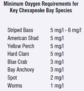
"Hypoxia" (lack of oxygen) in the bay is caused by activities on the land. The murder weapons are located some distance away from the victims.
In Northern Virginia, suburban homeowners who over-fertilize lawns (as well as developers who strip off vegetation without erecting effective silt fences to capture sediment after rainstorms, farmers who allow cows to poop directly in creeks, etc.) are killing the critters in the bay.
Major storms in the summer wash nutrients into the Chesapeake Bay, fueling a spike in algae which then die and create a dead zone. Wintertime storms, such as Superstorm Sandy in October 2012, cause less damage because the algae growth is limited during cold weather.
The Atlantic Ocean averages 35 parts per thousand (35 parts per milliliter), or 3.5% salt. What is the salinity in the Potomac River near Mason Neck?
If a major hurricane drops 10 inches of rain in the Shenandoah Valley, rivers will flood but salinity in the Shenandoah will not change significantly - because Virginia rivers are "freshwater" above the Fall Line.
Downstream of the Fall Line, rivers usually have a lens of fresh water floating on the surface for miles - but close to the Fall Line, there may be heavier saltwater underneath that lens, down at the river's bottom. The salinity in the bay itself will change if a major hurricane or snowmelt like "Snowpocalypse" blizzard (February, 2010) sends enough freshwater downstream.
Why are there oyster aquaculture projects along the Potomac River in Northumberland County, but not in Fairfax County?
Female blue crabs spend the winter near the mouth of the Chesapeake Bay. They are loaded with fertilized orange eggs on their shell, so the females are called sponge crabs.
Do the sponge crabs move closer to the mouth of the Chesapeake Bay in the Fall to overwinter in saltier waters (with 20-30 parts per thousand salt) or fresher waters (with 0-10 parts per thousand salt)?
Maryland biologists seek to limit the winter harvest of "pregnant" crabs. Who benefits from protecting the crabs? (Answer: everyone throughout the Bay, when there is a population boom the following spring.) Who loses the chance to make some money crabbing, if the traditional winter season is closed? (Answer: crabbers who live near the mouth of the bay... which means crabbers who live in Virginia.)
Crab biology is not based on political boundaries, but are you surprised that the Virginia Marine Resources Commission was more reluctant than regulators in Maryland to limit the harvest of sponge crabs in the winter?
the Chesapeake Bay salinity varies throughout the tidal cycle, as salty seawater interacts with freshwater from rivers (and freshwater floats on the top, so the water at the bottom of the bay is saltier)
Source: Virginia Institute of Marine Science (VIMS), Chesapeake Bay Salinity Distribution and Current
On which side of the Eastern Shore are Chincoteague Salts grown?
The Chesapeake Bay salinity averages 13-17 parts per thousand (ppt), while Chincoteague Bay is nearly as salty as the Atlantic Ocean (35 ppt). The taste of oysters is affected by the water in which they are grown, especially the salinity. Aquaculturalists are creating brand names, such as Olde Salts and Chincoteague Salts, to identify oysters from the Chincoteague Bay.
Wine enthusiasts discuss how the terroir of a vineyard (its soil, climate, and other local geographic characteristics) affect the taste of the wine. Oyster enthusiasts are beginning to discuss merroir, the marine equivalent of terroir.
Be the first on your block to become a connoisseur, or even an oyster snob. Oysters grown in water with high salinity are reputed to have a crisper finish than the buttery oysters from the Rappahannock River. (Hmmm, can you taste the seagrass overtones, with a slight hint of pepper...)
Until recently, restoration of the oyster beds in the Chesapeake Bay watershed was tied to the restoration of commercial oyster harvesting at the same time.
Maryland/Virginia would finance the planting of oysters on "public rocks," and watermen would harvest the oysters. It was a put-and-take fishery, comparable to dumping many bass into a commercial pond and having anglers pay for an almost-guaranteed catch.
Result of planting oysters on "public rocks" and allowing commercial harvest that same year: minimal or no increase in total oyster population.
New approach:
Abandon the effort to restore the lifestyle of the watermen.
Create no-harvest sanctuaries wherever oysters are planted at public expense, so natural oyster reproduction from adults in sanctuaries will increase the number of oysters throughout the entire bay.
Encourage private aquaculture. Lease publicly-owned submerged land to private oyster farmers (aquaculturalists), who will grow oysters in cages.
Social impact: most oysters will be harvested from cages on private aquaculture farms, not by traditional watermen working on "public rocks."
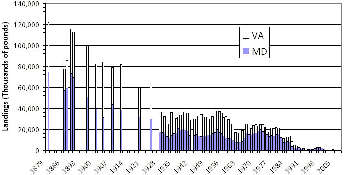
Chesapeake Bay oyster harvest has dropped dramatically in the last century
Source: National Oceanic and Atmospheric Administration (NOAA), Oysters
Oysters and menhaden eat the phytoplankton (algae) and zooplankton in the water of the Chesapeake Bay. They filter the water, straining out the excessively-high quantities of algae and converting it into protein that humans can use.
Humans do not eat menhaden directly. Instead, we squeeze and cook ("reduce") the oil rich in Omega-3 fatty acids from the fish, and use that oil for cooking or as a nutritional supplement.
Reedville is the site of the last menhaden processing plant on the East Coast. The town used to stink - literally - of oily fish being heated and squished, but new drying techniques have eliminated the odor. In fact, the old Omega Protein smokestack has been torn down.
Regulations that limit the harvest of menhaden are controversial. Recreational anglers want to limit commercial harvest of menhaden by Omega Protein so striped bass (and other species preferred by anglers) will have plenty of food swimming in the bay. While biologists debated the level of harvest that affects the ecology of the bay, Omega Protein officials have made clear that reduced harvest levels translates into reduced hiring and increased unemployment at Reedville.
In winter, female blue crabs migrate south towards the mouth of the Chesapeake Bay. The females are covered with orange eggs during the winter, resembling a sponge.
Blue crab eggs require the more-saline water near the mouth of the bay. After hatching, the first larval stage washes out into the Atlantic Ocean, then later stages ride currents back into the brackish bay, where Submerged Aquatic Vegetation offers habitat for growing into a mature crab.
Virginia used to allow watermen to dredge up the "pregnant" sponge crabs, during the winter season when other species were not suitable for fishing. Maryland objected strenouously, since the blue crab population was far too low - but the crabs wintered in Virginia, and Virginia watermen made a profit from the harvest, so the Virginia Marine Resources Commission (VMRC) permitted the winter dredging.
Several years ago, the blue crab population crash made clear that additional protection was no longer an option, whatever the socio-economic impacts on Virgnia-based watermen. VMRC banned the winter dredge fishery, and crab populations have rapidly recovered.
Pollution has been killing the Chesapeake Bay for decades, even centuries. Today, the pollution reaching the bay that needs to be controlled through a "Total Maximum Daily Load" (TMDL) cap is not bacteria from sewage, or industrial wastes.
The TMDL caps are designed to limit the amount of nitrogen, phosphorous, and sediments that reach the bay.
Nitrogen and phosphorous are nutrients, common in fertilizer applied to suburban lawns and farm fields. Nitrogen and phosphorous help plants grow in the water of the Chesapeake Bay - too much algae then die and drift to the bottom. As the plant material decomposes on the bottom, it sucks so much oxygen out of the water that fish, crabs, and oysters can't survive.
Sediment coats shellfish, physically blocking their ability to take in water and extract food. Sediment also coats Submerged Aquatic Vegetation (SAV), blocking sunlight and limiting the growth of the "grassy pastures" that provide essential habitat for fish and crabs on the bottom of the bay.
Portfolio Preparation:
For submission on December 8, convert your various site reports into your Neighborhood Portfolio, incorporating feedback and adding graphics.
If a young child or potential new homebuyer asked you "why is this place different," what would you say? What makes your site special, in some way?
From a historical perspective, you can use the Virginia Landmarks Register to help, or check the website of your county historic society. What happened at your site that is interesting to at least some audience? How is your site connected to other events/people that have achieved some measure of fame? How did history touch your site, and how can visitors/residents connect to that history? Is there some object still remaining (perhaps a house), or a streetcorner/field still remaining that can be associated with events/people of significance?
If just "ordinary" people occupied your site, how could you bring their story to life? What graphics - pictures, maps, diagrams - illustrate how your site has a heritage?
What natural characteristics make your site special? If your site is already a recreation/tourist attraction, what specific aspect of its geology/vegetation/water/etc. has the most interesting story? Identify a specific location where it is most appropriate to tell that story, and then tell it with words and pictures.
Does your site have local, state, or national significance? If you think the site is not historic or appropriate to label as "special" in some way (in your opinion), why not?
Its relatively easy to look back 20-50 years and envision the appearance of your site when Ronald Reagan and John F. Kennedy were president. Now look forward 20-50 years. What is likely to occur at your site? How will it change over time?
Even if your site is a protected park, the current cultural heritage and natural features may be transformed in some way by new settlement patterns, revisions in the current transportation network, even climate change. Will the people who live at/visit your site in 20-50 years look just like the people who live at/visit the site today? Will the roads/trails connecting your site to other areas be changed as vehicles take advantage of new technology and energy sources? How might the areas now dedicated to parking cars be used for different purposes in 20-50 years?
Now one more mental stretch. You have looked back at your site when Native Americans hunted and perhaps lived there, 400 years ago. You have considered how colonial settlement affected your site soon afterwards. Now look forward 400 years. When Jamestown "commemorates" the 800th anniversary of the arrival of English colonists, what will your site look like?
Exam Preparation:
Start reviewing previous quizzes, see where you missed questions, and clarify with me via e-mail if you do not understand the correct answers. You may see similar questions again on the Final Exam.

