Week 9: "We the People" - Politics and Government of Virginia
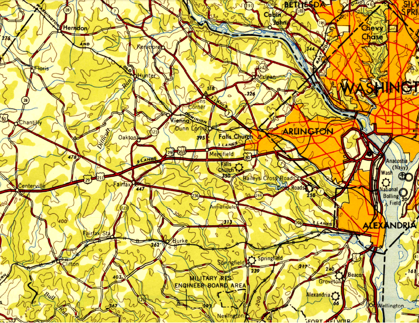
Northern Virginia in 1948 - before population growth led to the Beltway and before Tysons developed as an Edge City
Source: US Geological Survey, 1948 1X2 quadrangle topo map
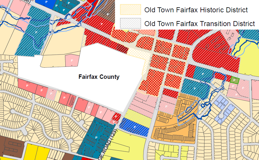
Zoning Map for Old Town Fairfax
(Fairfax County courthouse, in white area, is not in the city. Fairfax City handles planning/zoning for areas within boundaries of city, but can't control development of county property - so there is no city zoning for county courthouse.)
Source: City of Fairfax
Within Virginia, there are regions with enough common characteristics to be distinct from each other... but consensus on regional boundaries is rare. Each person, and each marketing agent for tourism and economic development, makes their own determination.
The NOVA (Northern Virginia) vs. ROVA (Rest of Virginia) divide is clear if you look at growth rate, natural population increase/decrease, educational attainment, and income.
If you were a high-tech firm, why would you expand operations in Northern Virginia, with its high wage costs and terrible traffic congestion? Why not put your business in Danville, where unemployment is high and people will work for far less?
You have already examined the Physiographic Regions of Virginia (Week 2), plus Virginia and the Outer Continental Shelf (Week 1), Where Are the Appalachians? (Week 2), "The Northern Neck" Is Not "The Peninsula" (Week 3), and Why Virginia's Cities and Towns Are Located Where They Are (Week 6).
Check out some sections of Virginia that are different from the traffic and culture so familiar to those of us who live in Northern Virginia:
Jamestown about 1614 - the first English town in Virginia expanded outside the triangular fort
Source: National Park Service - Sidney King collection of paintings created for the 350th Anniversary of Jamestown
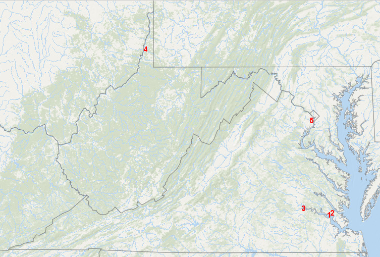
after colonization started in 1607, Virginia has had five capitals at Jamestown (1), Williamsburg (2), Richmond (3), plus Wheeling (4) and Alexandria (5) during the Civil War according to Union officials
Source: ESRI, ArcGIS Online
In 1967, the US Supreme Court ruled that state bans blocking interracial marriages (anti-miscegenation statutes) were inconsistent with the US Constitution. The plaintiffs were Richard and Mildred Loving, who lived in Caroline County near the location where the State Fair is now held each Fall.
The landmark Supreme Court decision in that case, ironically named Loving v. Virginia, was cited by the Virginia judge who ruled in 2014 that the ban on same-sex marriages was also not legal.
The Virginia judge who in 1965 had originally found the Lovings guilty of violating state law expressed an understanding of geography that became famous/infamous:1
Almighty God created the races white, black, yellow, malay and red, and he placed them on separate continents. And, but for the interference with his arrangement, there would be no cause for such marriage. The fact that he separated the races shows that he did not intend for the races to mix.
the only Catholic elected to the General Assembly in colonial Virginia was George Brent, from Stafford County
If Potomac Creek had been defined as the border between Maryland and Virginia as Lord Baltimore once claimed, then the Brents would have been political leaders in Maryland - a different colony, and one that was more welcoming to Catholics.
Catholics have been in Virginia since the Spanish missionaries in 1570. Catholics have not always been welcomed, however. George Kendall was executed in 1607 as a Spanish spy and Catholic sympathizer.
Catholics were not officially granted the right to worship as they pleased in Virginia until after the General Assembly passed the "Act for Establishing Religious Freedom" in 1785. Individual Catholic families were vulnerable to fines or censure until James Madison maneuvered the approval of the legislation that Thomas Jefferson had first introduced in 1779.
The Act for Establishing Religious Freedom was proposed when it appeared the American Revolution might fail, and public support needed to be rallied from all sources. The act was adopted just three years before the Constitution was ratified, and six years before the First Amendment ("Congress shall make no law respecting an establishment of religion, or prohibiting the free exercise thereof; or abridging the freedom of speech...") made the protection of religious freedom an explicit constraint on the Federal government.
The Bill of Rights limited the powers of only the Federal government. State governments could continue to discriminate based on religion until passage of the 14th Amendment after the Civil War, and Supreme Court rulings that determined the limits in the Bill of Rights on the Federal government also applied to the states.
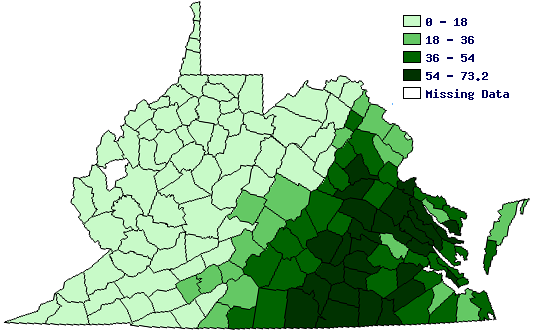
in 1860's, the percentage of the population held in slavery varied dramatically across Virginia - think that affected how people in the western counties viewed secession?
Source: Historical Census Browser - 1860
Over the last 50 years in Northern Virginia/Richmond/Hampton Roads, we have expanded roads/created passenger rail systems/synchronized traffic lights/built interchanges, and implemented other techniques that address the supply side of traffic congestion. Have we solved the traffic congestion problem?
Do we just need to double down and just build even more capacity to move cars/people from home to work (adding ferries, for example)?
Do you think more-of-the-same, for another 50 years, would solve the problem... or does a long-term solution to traffic congestion require something more than just expanding transportation infrastructure? If so, what is that "something more"?
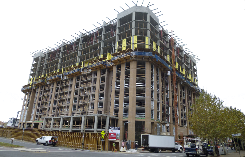
Tysons is the most obvious example today of official efforts to increase population density and provide transit service.
Instead of having 50-80,000 people commute from houses elsewhere to jobs in Tysons, creating horrible congestion - get some of those commuters to live in Tysons.
Few existing residents now commuting to Tysons will move, no matter how many condos are built at Tysons. Kids are already accustomed to their schools, spouses have jobs in the area, friends have been made in the neighborhood - and in today's economy, a business merger could make a job at Tysons into a job at Reston, Bethesda, or no job at all.
New residents who move to the DC area might choose to live in Tysons rather than in western Loudoun County or in Stafford County subdivisions. If new workers lived in Tysons, then those workers would not create new traffic congestion on I-66 or I-95.
Reducing transportation demand through land use decisions can be effective, but only if measured over 10-30 years. Building a new highway or starting a new bus route will always provide a quicker short-term fix for congestion.
should local political leaders create zoning that encourages denser population density,
or is greater density - at least near where you live - the wrong solution to traffic congestion?
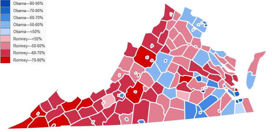
the urban areas and the rural areas vote differently...
in the 2012 election for president, only a handfull of counties west of the Fall Line voted for the Democratic candidate - but look who won many of the urbanized cities, even west of the Blue Ridge
Source: Wikipedia, United States presidential election in Virginia, 2012
In what political jurisdiction is your site located? How many members are on its elected Board of County Supervisors/City Council/Town Council? If you live in a jurisdiction with districts for elected officials (unlike Arlington County, where everyone on the Arlington Board is elected county-wide), who is elected locally to the Board of County Supervisors/City Council/Town Council to represent your site?
Local elected officials determine local property tax rates. What is your jurisdiction's Real Estate rate per $100 of assessed valuation? (Look at the Virginia Department of Taxation site for Local Tax Rates Tax Year 2014).
property taxes might deter people from living at your site, or opening/growing a business? Are other economic factors more significant, and political candidate's claims that taxes are pushing business to other jurisdictions are overblown?
Are most residents in your area owners or renters - and on what basis do you make that judgment? You can look at the Bureau of Census Quickfacts data for the entire jurisdiction, but why is your local site different from "average"?
How congested is traffic? Is there a rush hour when local residents drive to jobs that are located elsewhere, or is there congestion because people who live elsewhere are driving to jobs at your site?
How did your jurisdiction vote for president in 2012? Can you tell whether your site is tilted towards one political party or the other, judging from signs in the yards or stickers on car bumpers? Did the election results in previous years shape how your site evolves? Will the election in 2017 for new members of the General Assembly have a greater impact than this year's presidential election?
Which one official at the local, state, or national level, has the greatest opportunity to make your place "better" in some way. Based on your personal opinion of "better," if you had a chance to spend 5 minutes with that official... what would you ask that person to do for your site?
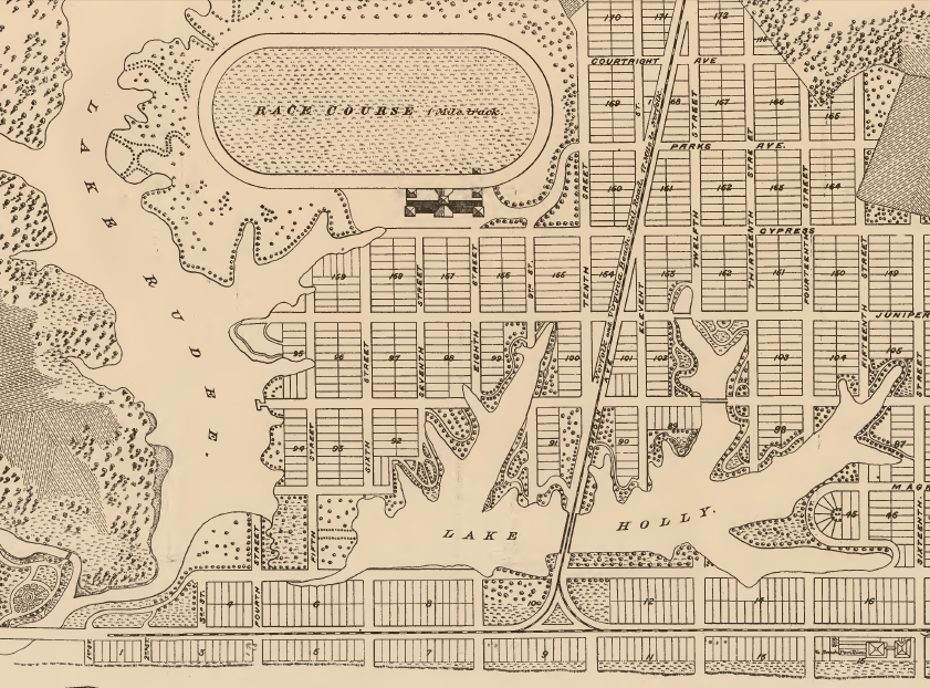
in 1883, the Norfolk and Virginia Beach Railroad and Improvement Company created the resort community of Virginia Beach in Princess Anne County - before that investment, the Atlantic Ocean shoreline was a place for commercial fishermen and the United States Life-Saving and Coast Guard Service
Source: Library of Virginia, Kicking up a Stink in Virginia Beach